August 24th, 2016 Tornado Outbreak
 |
 |
 |
 |
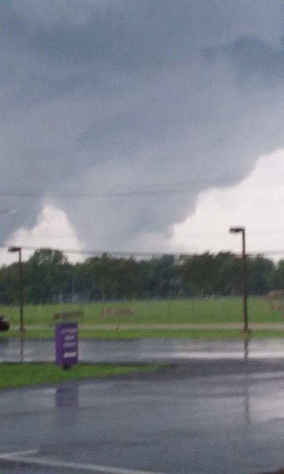
| Image 1. Receipt traveled 30 miles into Marion, IN-from the Kokomo, IN EF-3 (Trained Spotter Lisa Rhoton) |
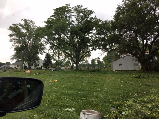
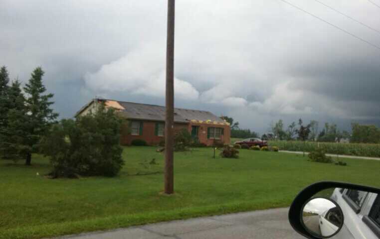
Image 2. EF 3 near Woodburn, IN (NWS Storm Survey) |
Image 3. Tornado damage near Roberts/Doty Roads-Woodburn, IN (Scott Jordan Drone Footage/NWS Storm Survey) |
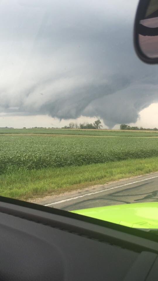
Image 4. Tornado SE Van Wert, OH (R. Contreras) |
Working Together to Save Lives
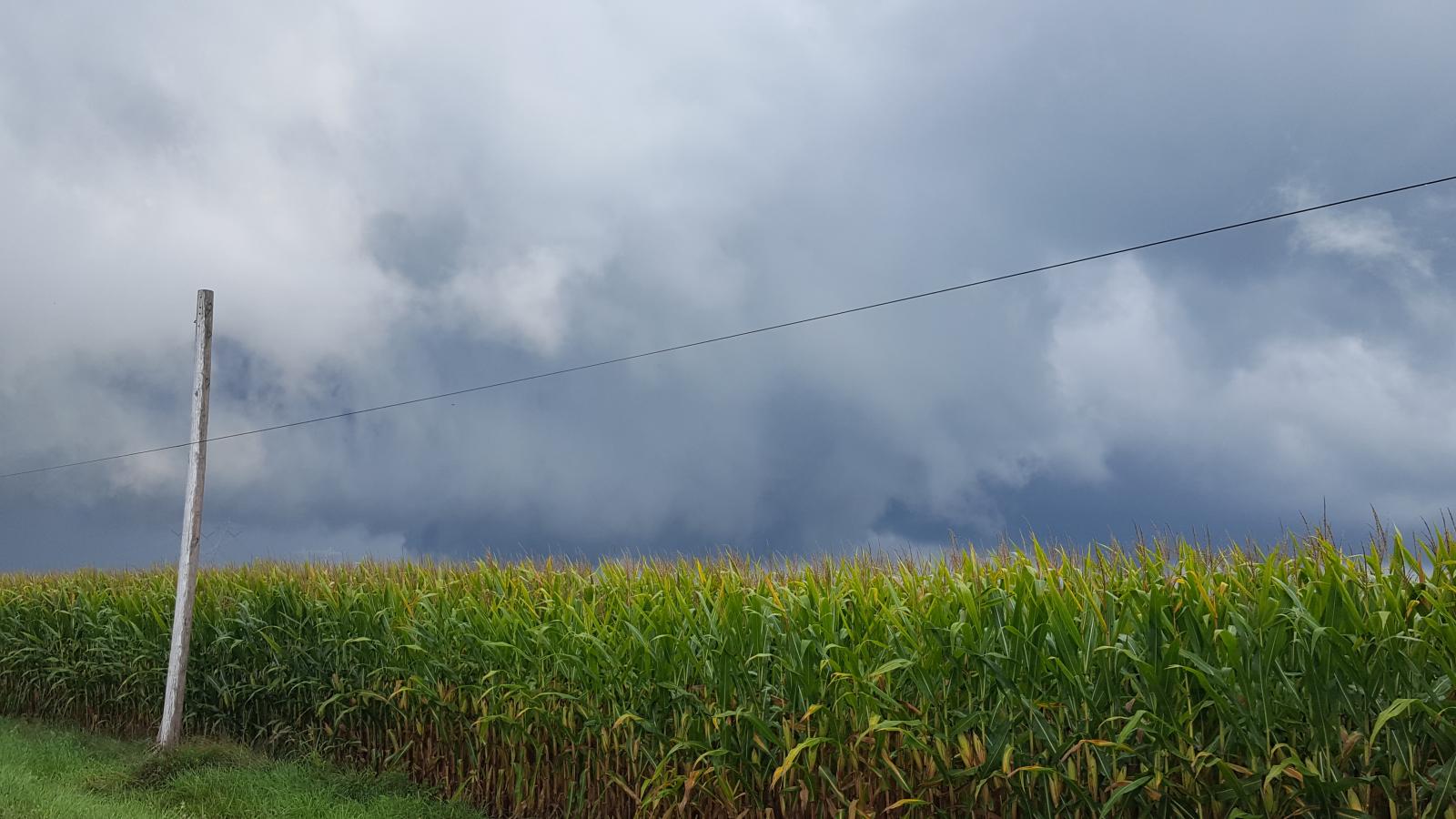
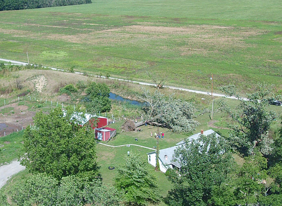
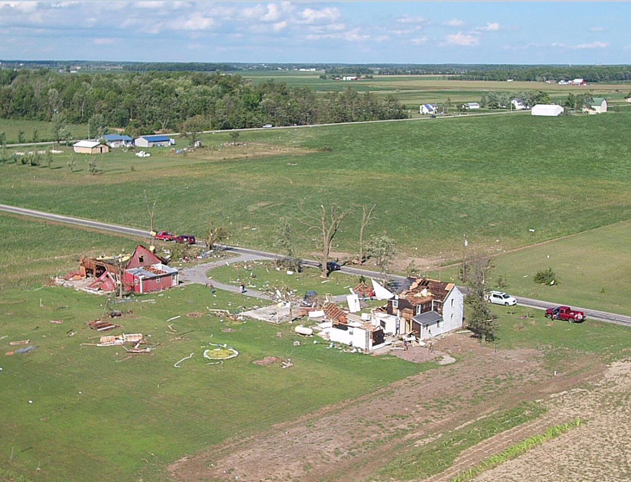
The tornado outbreak on August 24th, 2016 was a great testimony to how strong partner and public relationships save lives during active weather. There were 14 tornadoes in the IWX Forecast Area on August 24th. Amazingly, there were NO fatalities and only one reported minor injury. Communication between emergency managers, trained spotters, media personnel, the public, and the National Weather Service was crucial to preventing the loss of life. Timely and accurate reports sent in to IWX during the event helped us to make more effective warning decisions. Reports, videos, and pictures quickly sent to us after the event helped us to identify where to start surveying the damage. Thanks to those who provided drone footage/support and fly overs for quick and thorough tornado track and damage assessment (Scott Jordan for assistance with the Woodburn and Cecil tornado surveys, storm spotters,eyewitnesses,law enforcement, Emergency Management, and the Civil Air Patrol).
Thank you to our surrounding offices for supporting operations while we completed damage surveys. NWS Grand Rapids, MI provided service back up on August 25th so that we could send more survey teams and start work on this webpage. Thank you to NWS Indianapolis and Detroit for conducting/assisting with damage surveys. Thanks to NWS Central Region Headquarters and the Quick Response Team for their assistance with the Woodburn, IN EF-3 Tornado rating.
Quick Summary: August 24, 2016 Tornado Outbreak
Help the National Weather Service Build a Weather Ready Nation
NWS Northern Indiana Storm Spotter Training & Online Training
Weather Ready Nation Ambassador
Thunderstorm and Tornado Safety
Page last updated at 1 PM EDT August 28th, 2016
Detailed Summary
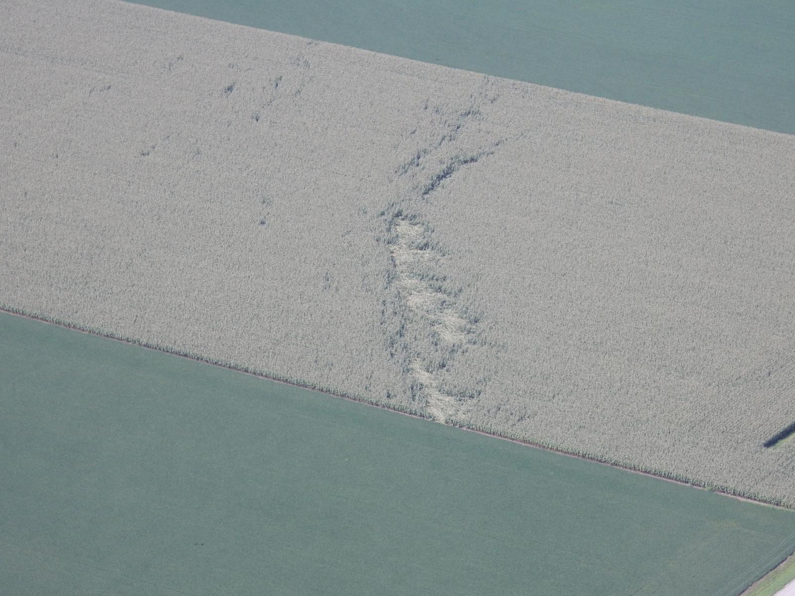
Tornadoes
Rotational Tracks
This is an image from our radar showing the rotational tracks of the storms, and where possible tornadoes may have occurred.

Image 1. Rotational Tracks August 24, 2016 from radar. Courtesy of NSSL
Specific Tornado Details
Damage surveys from Thursday and Friday have resulted in 14 confirmed tornadoes across northern Indiana and northwest Ohio. All data presented is considered preliminary and subject to change. See the most recent public information statement for the latest update.
|
Tornado 1 - 4 miles east Van Buren
|
||||||||||||||||
|
Tornado 2 - 3.7 miles NW of Woodburn
|
||||||||||||||||
|
Tornado 3 - 3.5 miles NW Berne
|
||||||||||||||||
|
Tornado 4 - 4.2 miles NE of Antwerp
|
||||||||||||||||
|
Tornado 5 - 2 miles NE of Peru
|
||||||||||||||||
|
Tornado 6 - 2.8 miles N-NW of Defiance
|
||||||||||||||||
|
Tornado 7 - 8 miles SW of Van Wert
|
||||||||||||||||
|
Tornado 8 - 4.8 miles NW of Van Wert
|
||||||||||||||||
|
Tornado 9 - 4.8 miles SW of Napoleon
|
||||||||||||||||
|
Tornado 10 - 3.9 miles NE of Van Wert
|
||||||||||||||||
|
Tornado 11 - 10.1 miles NE of Van Wert
|
||||||||||||||||
|
Tornado 12 - 3 miles SE Liberty Center
|
||||||||||||||||
|
Tornado 13 - Dupont
|
||||||||||||||||
|
Tornado 14 -3 miles SSW New Bavaria
|
||||||||||||||||
The Enhanced Fujita (EF) Scale classifies tornadoes into the following categories:
| EF0 Weak 65-85 mph |
EF1 Moderate 86-110 mph |
EF2 Significant 111-135 mph |
EF3 Severe 136-165 mph |
EF4 Extreme 166-200 mph |
EF5 Catastrophic 200+ mph |
 |
|||||
Photos/Videos
Photos are sorted by tornado number. Have a cool photo/video to share with us? If so, send us an email at w-iwx.webmaster@noaa.gov with the photo and a LINK to the video. We will of course give submissions appropriate credit where it's used-in your email make sure to give us permission to use it on the webpage and in weather education/training content. If for some reason your photo/video is not credited or labeled properly, please send us an email with the image number and correction. Thank you to trained spotters, emergency management, and all others who sent us these great materials. We appreciate you helping us to piece together and archive what happened during this unusual event. It is truly a team effort!
Tornado 1: EF-0 Located 4 E Van Buren, IN
Wells County
 |
 |
 |
 |
| Image 1. Two miles West of I 69 near Van Buren, IN (Trained Spotter, David Buell) |
Image 2. Near Dillman, IN (Trained Spotter, David Buell) |
Image 3. Tree Damage on W CR 900S Dillman, IN (NWS Storm Survey) |
Image 4. Minor Structural Damage on W CR 900S Dillman, IN (NWS Storm Survey) |
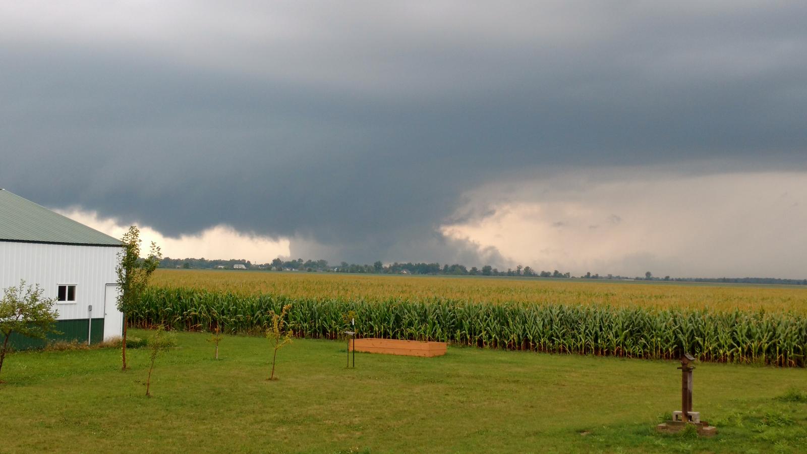
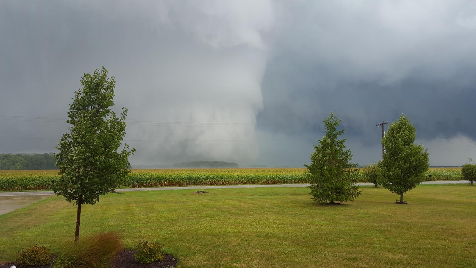
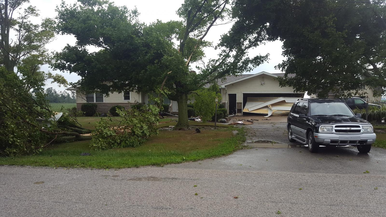
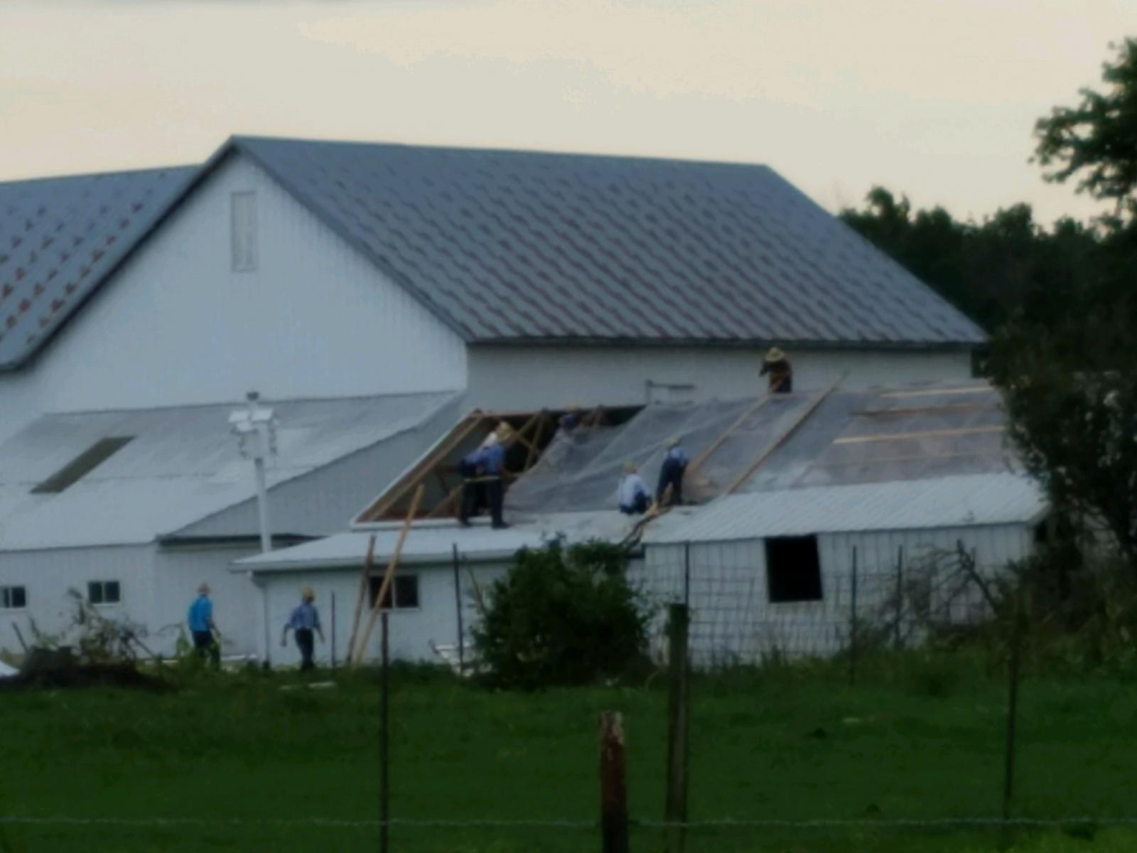
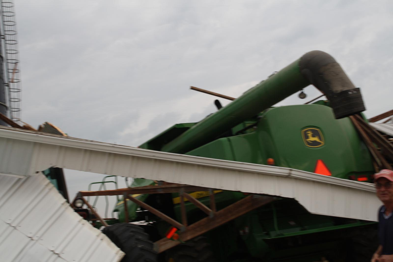
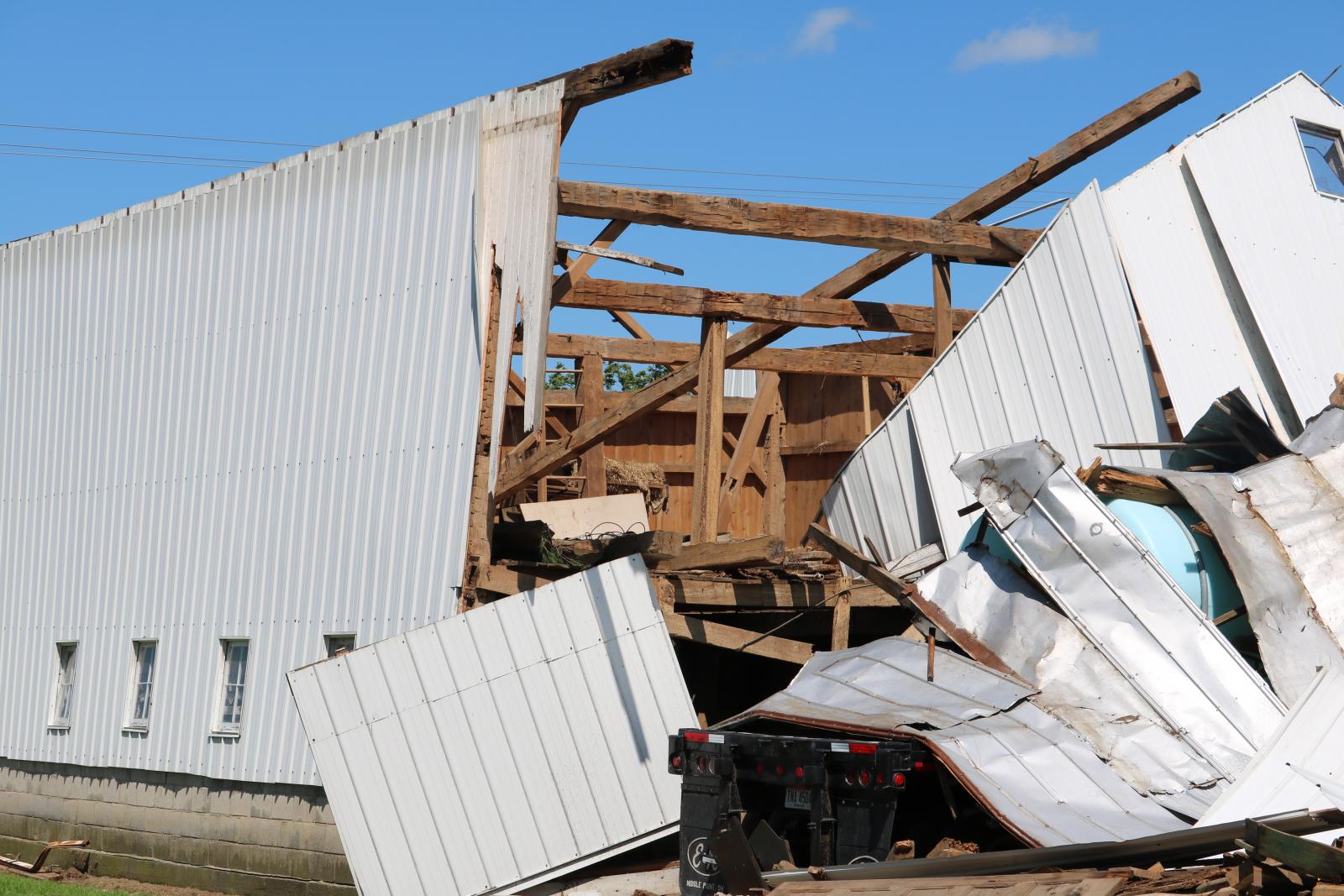
Tornado 2: EF-3 Located 3.7 NW Woodburn, IN
Allen County
 |
 |
 |
|
| Image 1. SR 101/Notestine Rd NW Allen County, IN (Steve and Linda Nardin, Trained Spotters/Amateur Radio Operators) |
Image 2. SR 101/Notestine Rd NW Allen County, IN (Steve and Linda Nardin, Trained Spotters/Amateur Radio Operators) |
Image 3. Roberts and Doty Rd Area near Woodburn, IN (Scott Jordan Drone footage) |
Image 4. Roberts and Doty Rd Area near Woodburn, IN (Scott Jordan Drone footage) |
 |
 |
 |
 |
| Image 5. Flutter Rd/Legends Parkway, NE of Fort Wayne, IN (Ethan Cameron, Trained Spotter) |
Image 6. Flutter Rd/Legends Parkway, NE of Fort Wayne, IN (WANE-15 Hannah Strong) |
Image 7. Slusher Rd/Gustin Rd in Woodburn, IN (Chad Kipfer) |
Image 8. 8600 Block Bull Rapids Rd Woodburn, IN (Ryan Chandler) |
 |
 |
 |
 |
| Image 9. 8600 Block Bull Rapids Rd Woodburn, IN (Ryan Chandler) |
Image 10. 8600 Block Bull Rapids Rd Woodburn, IN (Ryan Chandler) |
Image 11. 8600 Block Bull Rapids Rd Woodburn, IN (Ryan Chandler) |
Image 12. Near Doehrman/Ehle roads near Woodburn, IN (NWS Storm Survey) |
 |
|
 |
 |
| Image 13. Near Doehrman/Ehle roads near Woodburn, IN (NWS Storm Survey) |
Image 14. Near Doehrman/Ehle roads near Woodburn, IN (NWS Storm Survey) |
Image 15. Near Doehrman/Ehle roads near Woodburn, IN (NWS Storm Survey) |
Image 16. Near Doehrman/Ehle roads near Woodburn, IN (NWS Storm Survey) |
 |
 |
 |
 |
| Image 17. Crop Damage Near Woodburn, IN (NWS Storm Survey) |
Image 18. Roberts Rd to Bull Rapids Rd near Woodburn, IN (Trained Spotter Curt Graber) |
Image 19. Tornado damage near Woodburn, IN (NWS Storm Survey) |
Image 20. Taken from just south of US 24, Woodburn Tornado (Jennifer Ortiz Coonrod) |
Videos: Courtesy Curt Graber
EF-3 near Woodburn, IN: Ryan Chandler
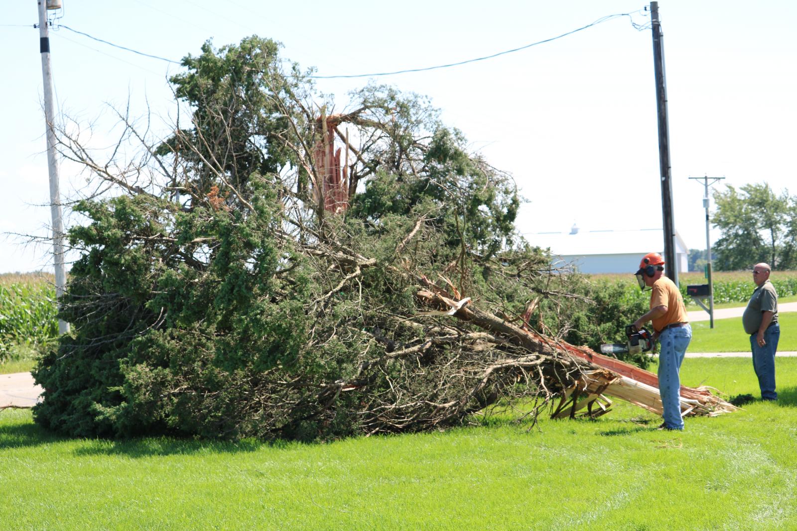
Tornado 3: EF-1 Located 3 NW of Berne, IN
Adams County
 |
 |
 |
 |
| Image 1. (Janelle Coates, near Monroe IN) |
Image 2. (Janelle Coates, near Monroe IN) |
Image 3. (Janelle Coates, near Monroe IN) |
Image 4. (Janelle Coates, near Monroe IN) |
 |
 |
 |
 |
| Image 5. (Janelle Coates, near Monroe IN) |
Image 6. (Janelle Coates, near Monroe IN) |
Image 7. (Janelle Coates, near Monroe IN) |
Image 8. (Janelle Coates, near Monroe IN) |
 |
 |
 |
 |
| Image 9. 1 SE Monroe, IN (Adams Co. EMA/Kyle Kauffman) |
Image 10. 1 SE Monroe, IN (Adams Co. EMA/Kyle Kauffman) |
Image 11. 1 SE Monroe, IN (Adams Co. EMA/Kyle Kauffman) |
Image 12. 2 NW Berne, IN (Adams Co. EMA/Paul D. Eicher) |
 |
 |
 |
 |
| Image 13. 2 NW Berne, IN (Adams Co. EMA/Paul D. Eicher) |
Image 14. 2 NW Berne, IN (Adams Co. EMA/Paul D. Eicher) |
Image 15. 2 NW Berne, IN (Adams Co. EMA/Paul D. Eicher) |
Image 16. 2 NW Berne, IN (Adams Co. EMA/Paul D. Eicher) |
 |
 |
 |
 |
| Image 17. Storm near 2 NW Berne IN (Adams Co. EMA/Steve Christner) |
Image 18. Storm near 2 NW Berne IN (Adams Co. EMA/Steve Christner) |
Image19. Storm near 2 NW Berne IN (Adams Co. EMA/Steve Christner) |
Image 20. Funnel Cloud 2 NW Berne IN (Adams Co. EMA/Steve Christner) |
Videos:
2 NW Berne, IN: Andrew Pursifull
Tornado 4: EF-2 Located 4.2 miles NE of Antwerp, OH
Paulding and Defiance Counties
 |
 |
 |
 |
| Image 1. Damage near Antwerp, OH (NWS Survey) |
Image 2. Tree/Roof Damage (NWS Survey) |
Image 3. Damage near Antwerp, OH (NWS Survey/Scott Jordan) |
Image 4. Damage near Antwerp, OH (NWS Survey/Scott Jordan) |
 |
 |
 |
 |
| Image 5. Damage near Antwerp, OH (NWS Survey/Scott Jordan) |
Image 6. Damage near Antwerp, OH (NWS Survey/Scott Jordan) |
Image 7. Damage near Antwerp, OH (NWS Survey/Scott Jordan) |
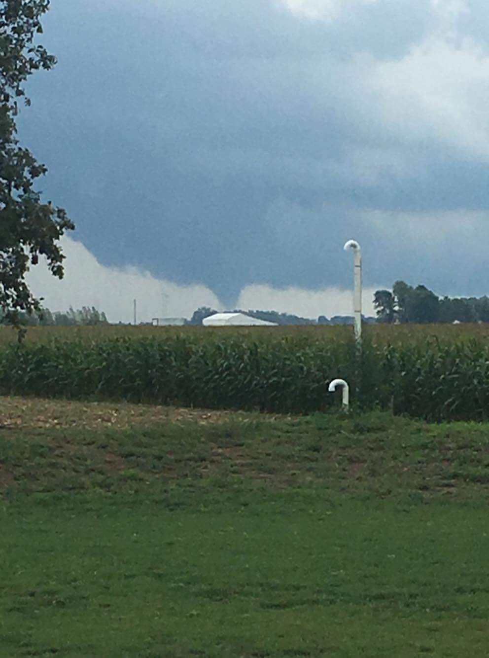
Image 8. Tornado near Antwerp, OH (Trained Spotter) |
 |
 |
 |
 |
| Image 9. Paulding/Defiance Co. Dmg (NWS Survey) |
Image 10. Paulding/Defiance Co. Dmg (NWS Survey) |
Image 11. Paulding/Defiance Co. Dmg (NWS Survey) |
Image 12. Paulding/Defiance Co. Dmg (NWS Survey) |
Videos: Brando Copic / Live Storms Media
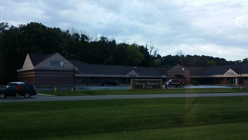
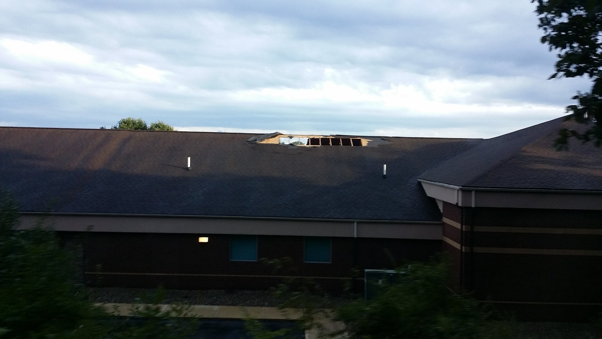
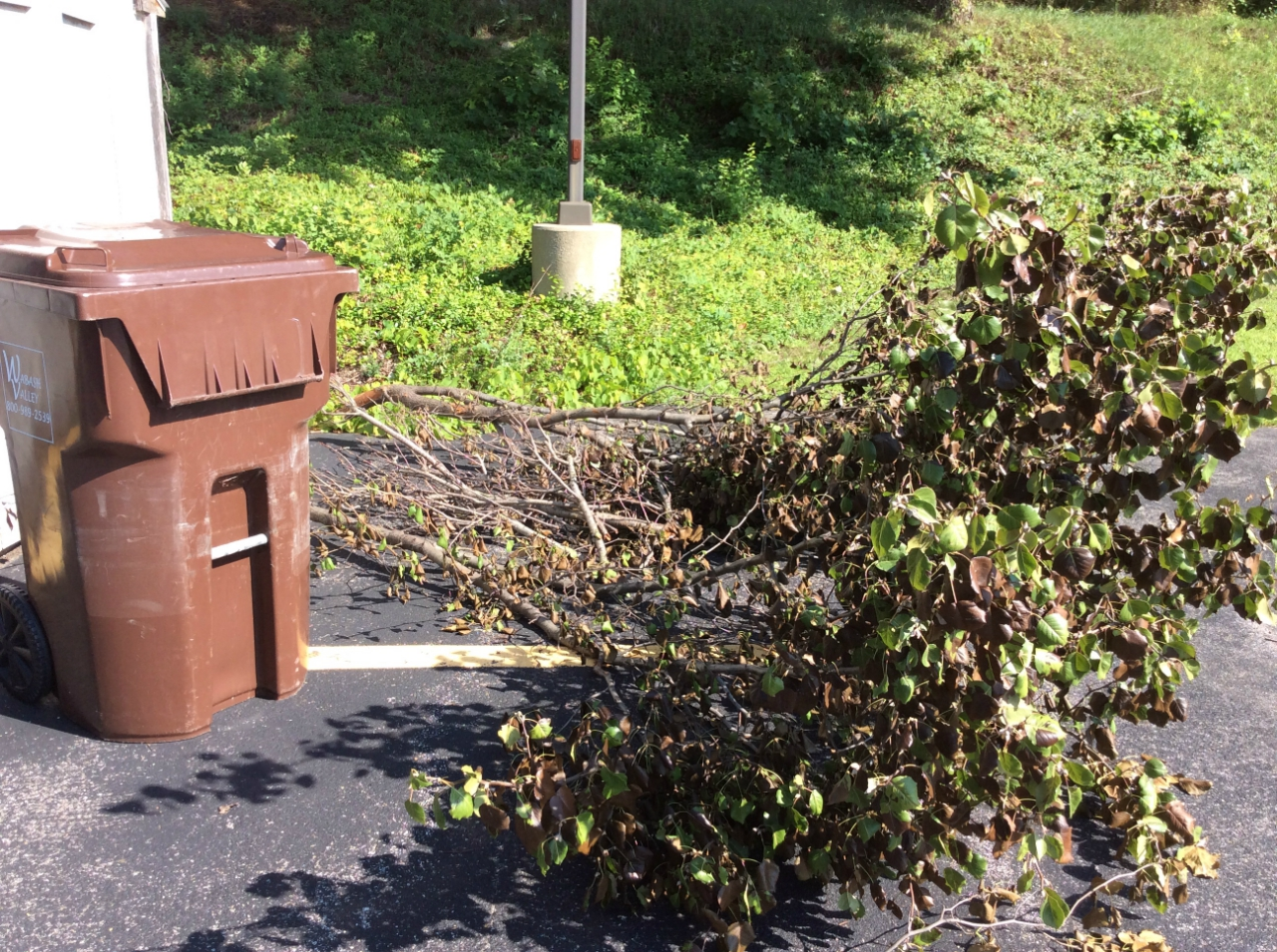
Tornado 5: EF-0 Located 2 NE of Peru, IN
Miami County
 |
 |
 |
 |
| Image 1. Damage to the Health Building (Greyson Wright) |
Image 2. Damage to the American Health Building (Greyson Wright) |
Image 3. Hardwood branches downed near Peru (NWS Survey) |
Image 4. Damage to the American Health Building (Miami County EMA) |
Tornado 6: EF-2 Located 2.8 NNW of Defiance, OH
Defiance County
 |
 |
 |
 |
| Image 1. EF-2 Tornado-NW of Defiance, OH (Jaycee Riley/ZR Photo) |
Image 2. EF-2 Tornado- NW of Defiance, OH (Jaycee Riley/ZR Photo) |
Image 3. EF-2 Tornado-NW of Defiance, OH (Jaycee Riley/ZR Photo) |
Image 4. Tornado NW of Defiance, OH (Trained Spotter Ben Kessler) |
 |
 |
 |
 |
| Image 5. Looking North from Defiance, OH towards SR 66 (Chris Mansfield) |
Image 6. Jerico Rd Damage near Defiance (NWS Survey) |
Image 7 Jerico Rd Damage near Defiance (NWS Survey/Scott Jordan) |
Image 8. Flory Rd Barn Damage (NWS Survey/Scott Jordan) |
 |
 |
 |
 |
| Image 9. SR 66 near Defiance (NWS Survey/Scott Jones) |
Image 10. Crop Damage south of Flory Rd on SR 66 (Defiance Co. EMA) |
Image 11. Roof damage Lot 117 (Defiance Co. EMA) | Image 12. Rath Builders Damage (Defiance Co. EMA) |
 |
| Image 13. Tornado-Defiance, OH (Trained Spotter Benjamin Kessler) |
Tornado 7: EF-1 Located 8 SW of Van Wert, OH
Tornado 8: EF-0 Located 4.8 NW of Van Wert, OH
Tornado 10: EF-0 Located 3.9 NE of Van Wert, OH
Tornado 11: EF-0 Located 10.1 NE of Van Wert, OH
Van Wert County
 |
 |
 |
 |
| Image 1. EF-1 8 SW Van Wert OH (Rick McCoy/Van Wert EMA) |
Image 2. EF-1 8 SW Van Wert OH (Rick McCoy/Van Wert EMA) |
Image 3. EF-1 8 SW Van Wert OH (Rick McCoy/Van Wert EMA) |
Image 4. EF-1 8 SW Van Wert OH (Rick McCoy/Van Wert EMA) |
 |
 |
 |
 |
| Image 5. Van Wert, OH Damage (NWS Survey) |
Image 6. Van Wert, OH Damage (NWS Survey) |
Image 7. Van Wert, OH Damage (NWS Survey) |
Image 8. Van Wert, OH Damage (NWS Survey) |
 |
 |
 |
 |
| Image 9. EF-0: 4 NE of Van Wert, OH (Rick McCoy/Van Wert EMA) |
Image 10. EF-0:10 NE of Van Wert, OH (Rick McCoy/Van Wert EMA) |
Image 11. EF-0:10 NE of Van Wert, OH (Rick McCoy/Van Wert EMA) |
Image 12. EF-0:10 NE of Van Wert, OH (Rick McCoy/Van Wert EMA) |
 |
 |
 |
| Image 13. EF-0 Tornado from SR 49, 5 NW Van Wert, OH (Trained Spotter) |
Image 14. Rotation NE Van Wert, OH (Bradley SwannTrained Spotter) |
Image 15. Near Van Wert, OH (Ian Bailey) |
Tornado 9: EF-1 Located 4.8 SW of Napoleon, OH
Henry County
 |
 |
 |
 |
| Image 1. Barn Destruction CR Q1 and CR 17: NW of Napoleon, OH (NWS Survey) |
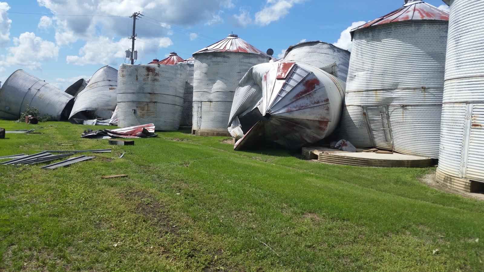
Image 2. Grain Bins Blown Down about 3 NW Napoleon (Michael Vorwerk) |
Image 3. Grain Bins Blown Down about 3 NW Napoleon (Michael Vorwerk) |
Image 4. Roof Damage about 3 NW Napoleon (Michael Vorwerk) |
 |
 |
 |
| Image 5. Near Napoleon, OH (Tony Mansfield) |
Image 6. Near Napoleon, OH (Tony Mansfield) |
Image 7. County Rd P, SW of Napoleon, OH (Benjamin Kessler) |
Videos: Courtesy Rich Miller/Tony Everhardt
Near Napoleon: Matthew Coressel
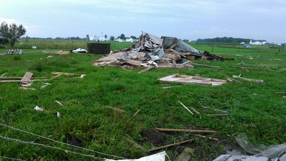
Tornado 12: EF-0 Located 3 E Liberty Center, OH
Tornado 13: EF-0 Located in Dupont, OH
Tornado 14: EF-0 Located 3 SSW New Bavaria, OH
Putnam/Henry Counties
 |
 |
 |
 |
| Image 1. EF-0 Tornado moving into Dupont, Ohio. Photo taken on Road 22K, about 5 miles south of Dupont. (Trained Spotter Geddy Davis) |
Image 2. Damage to siding of house on S. River street caused when the tornado touched down in field (Dustin Ladd, Dupont OH) |
Image 3. Damage to siding of another house from Tornado-located at intersection of S. River St/Maple St (Dustin Ladd, Dupont OH) |
Image 4. Drone flyover of the tornado path as it crossed into a bean field before entering Dupont, OH (Putnam Sheriff/EMA) |
 |
 |
 |
 |
| Image 5. Oak Tree snapped off on top on the NE side of Dupont, OH (NWS Storm Survey) |
Image 6. Tornado path through bean field (left of shed), minor damage to shed and a downed tree limb. From NE Dupont, OH (NWS Storm Survey) |
Image 7. Tornado snapped off tree limbs, tree branch can be seen hanging from power lines. Maple St/River St, Dupont, OH (NWS Storm Survey) |
Image 8. Tree limbs downed on Liberty Street in Dupont, OH (NWS Storm Survey) |
Videos:
Robin Worline's Community Gallery: Dupont Tornado
Ashley Lyn Gerken: North Liberty, OH Tornado
Dupont, OH Tornado Survey: Putnam Co Sherriff/EMA Drone Video
Radar
Below are select radar images from the event. Figure 1. is a loop of the event from 10 AM EDT-11 PM EDT August 24th, while figures 2-5 are screen shots of impressive radar data at certain times during the event.
 |
| Figure 1. Radar loop of storms moving across Indiana, Ohio, and southern lower Michigan. Loop is from 10 AM EDT-11 PM EDT August 24th, 2016. Images from the storm prediction center. |
Select Radar Images
 |
 |
 |
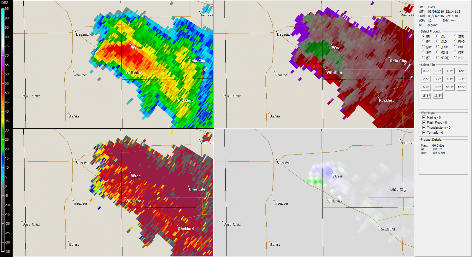 |
| Figure 1. Four panel radar data for the Woodburn, IN Storm at 5:25 PM EDT August 24th. Reflectivity shows a doughnut hole-signifying a bounded weak echo region. This is typical of strong rotation about a vertical axis, Velocity/NROT confirms the strong rotation. | Figure 2. Four panel radar data for the Woodburn, IN Storm at 5:31 PM EDT August 24th. Velocity shows stronger rotation, and it is now tighter. CC now clearly shows a debris ball from the tornado (blues/grays). NROT is showing stronger rotation. | Figure 3. Four panel radar data for the storm in Sherwood/Defiance, Ohio at 6:14 PM EDT August 24th. Notice the prominent hook shape in the reflectivity, typical of supercells. Also note rotation via the velocity couplet and the NROT. | Figure 4. Four panel radar data for the storm near Wren/Willshire, IN at 6:14 PM EDT August 24th. Broader rotation is present as seen in the Velocity/NROT images. Notice the hook shape in the Reflectivity, typical of supercells. |
For four panel images above: Left is reflectivity (Z), top right is Base Velocity (V), bottom left is Correlation Coefficient (CC), and bottom right is Normalized Rotation (NROT). To read more about radar signatures, click here. Dual pol information can be found here. Images were created using GR2Analyst.
Final Reports
000
NOUS43 KIWX 270018 AAA
PNSIWX

Public Information Statement
National Weather Service Northern Indiana
820 PM EDT FRI AUG 26 2016 /720 PM CDT FRI AUG 26 2016/

...NWS DAMAGE SURVEY FOR 08/24/2016 TORNADO EVENT Update #4...

.UPDATE...
Details include and update on two additional tornadoes identified in
Putnam County Ohio, with the second tornado briefly passing into
Henry County Ohio.

A continued thanks to our spotters, the public, emergency managers,
media partners and neighboring NWS offices for all of the information
and help in completing these surveys.

A special thank you to the residents and Mayor of Dupont for your
assistance with the damage assessment in Putnam County today.

Note: tornadoes below are listed in chronological order.

.Tornado 1 / Wells County...

Rating:                 EF-0
Estimated peak wind:    65 mph
Path length /Statute/:  0.04 miles
Path width /Maximum/:   20 yards
Fatalities:             0
Injuries:               0

Start date:             08/24/2016
Start time:             4:59 pm EDT
Start location:         4 miles east of Van Buren / Wells / IN
Start Lat/Lon:          40.6103 N / -85.4249 W

End date:               08/24/2016
End time:               5:00 pm EDT
End location:           4 miles east of Van Buren / Wells / IN
End_lat/lon:            40.6107 N  / -85.4244 W

A survey conducted along with eyewitness reports indicate that a funnel
cloud briefly made contact with the ground on county road west 900 south,
one half mile east of south 1100 west. A few tree branches were snapped,
the metal siding of a pole barn was partially sucked outward and an
unanchored wooden well house was drug into a nearby pond. This tornado
was in contact with the ground for about one minute.

.Tornado 2/ Allen County Indiana...

Rating:                 EF-3
Estimated peak wind:    160 mph
Path length /Statute/:  5.26 miles
Path width /Maximum/:   500 yards
Fatalities:             0
Injuries:               0

Start date:             08/24/2016
Start time:             5:27 pm EDT
Start location:         3.7 miles northwest of Woodburn / Allen / IN
Start Lat/Lon:          41.1475 N / -84.9187 W


End date:               08/24/2016
End time:               5:39 pm EDT
End location:           4.1 miles east of Harlan / Allen / IN
End_lat/lon:            41.1953 N / -84.8425 W

The tornado touched down roughly 1/4 mile northeast of the intersection
of Doty Road and Roberts Road in a crop field. The tornado tracked
generally in a northeasterly direction causing extensive structural
damage to homes, barns, trees and crops throughout the entirety of the
path. Additional details will be posted in our web story at
https://www.weather.gov/iwx/20160824_TornadoOutbreak.

.Tornado 3 / Adams County...

Rating:                 EF-1
Estimated peak wind:    100 mph
Path length /Statute/:  7.62 miles
Path width /Maximum/:   50 yards
Fatalities:             0
Injuries:               0

Start date:             08/24/2016
Start time:             5:49 pm EDT
Start location:         3.5 miles northwest of Berne / Adams / IN
Start Lat/Lon:          40.6832 N / -85.0247 W


End date:               08/24/2016
End time:               6:03 pm EDT
End location:           5.9 miles north northeast of Berne / Adams / IN
End_lat/lon:            40.7337 N / -84.8967 W

A survey and eyewitness reports along with an aerial survey by Emergency
Management indicated a funnel cloud was skipping along this path and
occasionally touching down. The aerial survey indicated several touch
downs within the middle of bean and corn fields. Ground survey found
several taller barn structures with partial roofs torn off and lofted
several hundred yards in pieces. Larger trees had large limbs broken
off while smaller trees were knocked down or uprooted.

.Tornado 4 / Paulding/Defiance Counties...

Rating:                 EF-2
Estimated peak wind:    130 mph
Path length /Statute/:  4.47 miles
Path width /Maximum/:   250 yards
Fatalities:             0
Injuries:               0

Start date:             08/24/2016
Start time:             5:53 pm EDT
Start location:         4.2 miles northeast of Antwerp / Paulding / OH
Start Lat/Lon:          41.2220 N / -84.6813 W


End date:               08/24/2016
End time:               6:04 pm EDT
End location:           1.5 miles south southeast of Mark Center / Defiance / OH
End_lat/lon:            41.2686 N / -84.6232 W

The tornado touched down roughly 1/5 mile west of the intersection of
Road 192 and Road 220 in a wooded area next to a residence. The tornado
tracked generally in a northeasterly direction causing extensive
structural damage to homes, barns, trees and crops throughout the
entirety of the path. Additional details will be posted in our web
story at https://www.weather.gov/iwx/20160824_TornadoOutbreak.

.Tornado 5 / Miami County...

Rating:                 EF-0
Estimated peak wind:    70 mph
Path length /Statute/:  0.06 miles
Path width /Maximum/:   20 yards
Fatalities:             0
Injuries:               0

Start date:             08/24/2016
Start time:             6:13 pm EDT
Start location:         2.0 miles north northwest of Peru / Miami / IN
Start Lat/Lon:          40.7740 N / -86.0796 W


End date:               08/24/2016
End time:               6:14 pm EDT
End location:           2.0 miles north northwest of Peru / Miami / IN
End_lat/lon:            40.7742 N / -86.0785 W

A storm survey and eyewitness reports indicated a brief touchdown on
the north side of Peru. Damage to shingles and sheeting of a roof was
noted at a medical center along with downed large tree limbs.

.Tornado 6 / Defiance County...

Rating:                 EF-2
Estimated peak wind:    120-125 mph
Path length /Statute/:  2.69 miles
Path width /Maximum/:   400 yards
Fatalities:             0
Injuries:               1

Start date:             08/24/2016
Start time:             6:28 pm EDT
Start location:         2.8 miles north northwest of Defiance / Defiance / OH
Start Lat/Lon:          41.3231 N / -84.3803 W


End date:               08/24/2016
End time:               6:34 pm EDT
End location:           4.2 miles north northeast of Defiance / Defiance / OH
End_lat/lon:            41.3461 N / -84.3397 W

A survey conducted along with eyewitness reports indicate a funnel
cloud made multiple touchdowns along this path. The initial touchdown
was northwest of Defiance along Christy road. Damage in this area
was tree branches up to 3 inch diameter broken off. The tornado
increased in intensity to EF2 north of Defiance along route 66.
Damage in this area consisted of structural with a roof blown off
of a business and transmission lines blown down. The tornado tracked
further northeast where damage was noted along Flory road, east of
route 66. Damage here consisted of roof damage to a residence and
collapse of a storage building to the east of the home. The end of
the damage path was located north of the intersection of Carpenter
road and Flory road where tree branches were broken off.


.Tornado 7 / Van Wert County...

Rating:                 EF-1
Estimated peak wind:    100 mph
Path length /Statute/:  5.5 miles
Path width /Maximum/:   75 yards
Fatalities:             0
Injuries:               0

Start date:             08/24/2016
Start time:             6:30 pm EDT
Start location:         8 miles southwest of Van Wert / Van Wert / OH
Start Lat/Lon:          40.8241 N / -84.7257 W


End date:               08/24/2016
End time:               6:41 pm EDT
End location:           4.4 miles west northwest of Van Wert / Van Wert / OH
End_lat/lon:            40.8881 N / -84.6646 W

A survey and eyewitness reports along with an aerial survey by Emergency
Management indicated a funnel cloud was skipping along this path and
occasionally touching down. First touch down was in a corn field just west
of a residence on Convoy Heller Road. Several trees were uprooted and
snapped off while some roof and siding damage occurred to the home. A large
two story garage/barn had mud thrown onto the eastern side of the building.
A window was broken inward while a vent on the building was blown outward.
The tornado continued skipping northeast hitting a large barn on US
highway 224. The roof of this building was blown off to the north and witnessed
by homeowner. The tornado continued skipping northeast, knocking down trees including
a large pine tree in a cemetery. Several small grave stones were also moved.


.Tornado 8 / Van Wert County...

Rating:                 EF-0
Estimated peak wind:    75 mph
Path length /Statute/:  1.5 miles
Path width /Maximum/:   25 yards
Fatalities:             0
Injuries:               0

Start date:             08/24/2016
Start time:             6:41 pm EDT
Start location:         4.8 miles west northwest of Van Wert / Van Wert / OH
Start Lat/Lon:          40.8878 N / -84.6698 W


End date:               08/24/2016
End time:               6:45 pm EDT
End location:           5.1 miles northwest of Van Wert / Van Wert / OH
End_lat/lon:            40.9071 N / -84.6579 W

Secondary spin up tornado from same mesocyclone as tornado 3. Damage found
from aerial survey by Emergency Manager of mainly crop damage to corn and
beans.

.Tornado 9 / Henry County...

Rating:                 EF-1
Estimated peak wind:    100 mph
Path length /Statute/:  2.69 miles
Path width /Maximum/:   150 yards
Fatalities:             0
Injuries:               0

Start date:             08/24/2016
Start time:             6:48 pm EDT
Start location:         4.8 miles west southwest of Napoleon / Henry / OH
Start Lat/Lon:          41.3823 N / -84.2161 W


End date:               08/24/2016
End time:               6:54 pm EDT
End location:           3.3 miles northwest of Napoleon / Henry / OH
End_lat/lon:            41.4115 N / -84.1786 W

A survey conducted indicates a funnel cloud made multiple touchdowns
along this path. The initial touchdown was in western
Henry county, along County road P and north of U.S. 24. Damage in
this area consisted of tree branches broken off. Further northeast
the tornado intensified to an EF1 north of County road P where roof
damage occurred to a residence. A storage building also sustained
significant damage. The tornado tracked northeast where damage was
noted at the intersection of County road 17 and County road Q1.
Damage in this area consisted of a demolished storage barn and roof
damage to a residence. Further northeast along highway 6 between
County road R and County road Q1, roof damage occurred to a
residence. Metal storage silos were also blown off of their
foundation. To the north of highway 6, tree branches were torn off
where the damage path ended.


.Tornado 10 / Van Wert County Ohio...

Rating:                 EF-0
Estimated peak wind:    65 mph
Path length /Statute/:  4.67 miles
Path width /Maximum/:   40 yards
Fatalities:             0
Injuries:               0

Start date:             08/24/2016
Start time:             6:51 pm EDT
Start location:         3.9 miles north northeast of Van Wert / Van Wert / OH
Start Lat/Lon:          40.9108 N / -84.5538 W


End date:               08/24/2016
End time:               7:04 pm EDT
End location:           8.6 miles northeast of Van Wert / Van Wert / OH
End_lat/lon:            40.9601 N / -84.4932 W

Damage found from aerial survey by Emergency Manager of mainly crop damage
to corn and beans. Tornado skipped once in middle of this path.

.Tornado 11 / Van Wert County Ohio...

Rating:                 EF-0
Estimated peak wind:    65 mph
Path length /Statute/:  2.46 miles
Path width /Maximum/:   20 yards
Fatalities:             0
Injuries:               0

Start date:             08/24/2016
Start time:             7:04 pm EDT
Start location:         10.1 miles northeast of Van Wert / Van Wert / OH
Start Lat/Lon:          40.9602 N / -84.4437 W


End date:               08/24/2016
End time:               7:10 pm EDT
End location:           12.6 miles northeast of Van Wert / Van Wert / OH
End_lat/lon:            40.9874 N / -84.4134 W

Damage found from aerial survey by Emergency Manager of mainly crop damage
to corn and beans.

.Tornado 12 / Henry County Ohio...

Rating:                 EF-0
Estimated peak wind:    65 mph
Path length /Statute/:  0.01 miles
Path width /Maximum/:   20 yards
Fatalities:             0
Injuries:               0

Start date:             08/24/2016
Start time:             7:19 pm EDT
Start location:         3.0 miles east southeast of Liberty Center / Henry / OH
Start Lat/Lon:          41.4342 N / -83.9518 W


End date:               08/24/2016
End time:               7:20 pm EDT
End location:           3.0 miles east southeast of Liberty Center / Henry / OH
End_lat/lon:            41.4342 N / -83.9518 W

A law enforcement officer saw a brief touchdown in a field. Only crop damage occurred.

.Tornado 13 / Putnam County Ohio...

Rating:                 EF-0
Estimated peak wind:    65 mph
Path length /Statute/:  1.26 miles
Path width /Maximum/:   25 yards
Fatalities:             0
Injuries:               0

Start date:             08/24/2016
Start time:             7:26 pm EDT
Start location:         0.5 miles south-southeast of Dupont / Putnam / OH
Start Lat/Lon:          41.0479 N / -84.3071 W

End date:               08/24/2016
End time:               7:29 pm EDT
End location:           0.75 mile north-northeast of Dupont / Putnam / OH
End_lat/lon:            41.0636 N / -84.2958 W
Rating:                 EF-0
Estimated peak wind:    65 mph
Path length /Statute/:  0.01 miles
Path width /Maximum/:   20 yards
Fatalities:             0
Injuries:               0

Numerous interviews with residents southeast of Dupont, Ohio described the rotating wall
cloud with funnel clouds lowering as the storm passed over. This tornado formed just south
of the Auglaize river in the middle of a corn field. Tree damage was noted in the tree
line on the south side of the river. Residents in Dupont reported the tornado lifted water
from the river before intensifying and accelerating to the north. The tornado continued
through the middle of Dupont and exited the north side of the town moving north-northeast
into a field of beans before dissipating north of town. Damage to siding, roofs, trees
and crops.  Damage was consistent with maximum winds of 65 MPH.

.Tornado 14 / Putnam/Henry County Ohio...

Rating:                 EF-0
Estimated peak wind:    65 mph
Path length /Statute/:  0.64 miles
Path width /Maximum/:   15 yards
Fatalities:             0
Injuries:               0

Start date:             08/24/2016
Start time:             7:48 pm EDT
Start location:         3.2 miles south-southeast of New Bavaria / Henry / OH
Start Lat/Lon:          41.1600  / -84.1879

End date:               08/24/2016
End time:               7:50 pm EDT
End location:           2.7 miles south-southeast of New Bavaria / Henry / OH
End_lat/lon:            41.1678  / -84.1814

This tornado was observed by local fire officials and reported to last very briefly before
dissipating as it crossed into Henry County. Very little damage reported or observed.


EF Scale: The Enhanced Fujita Scale Classifies Tornadoes into the
following categories.

EF0...Weak......65 to 85 mph
EF1...Weak......86 to 110 mph
EF2...Strong....111 to 135 mph
EF3...Strong....136 to 165 mph
EF4...Violent...166 To 200 mph
EF5...Violent...>200 mph

$$
Environment
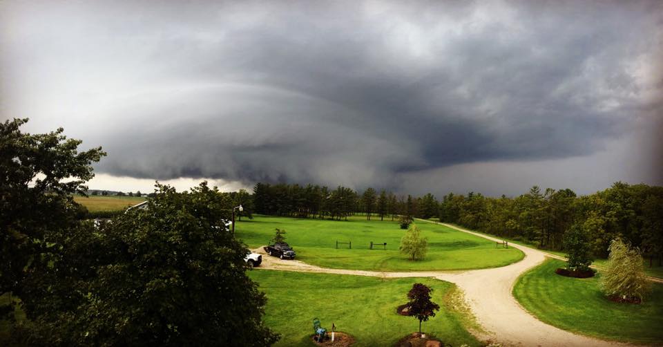
A unique combination of extreme low level moisture and a passing upper level disturbance provided the trigger for severe storms. Even though the clouds remained in place for most of the day and it did not get very warm, there was just enough instability to allow storms to develop. There was also a high degree of shear in the lowest levels of the atmosphere, which allowed multiple tornadoes to form.
Ingredients for Storms
Storms need moisture, instability, and lift (a trigger) to develop. Rotating storms that often produce tornadoes also need stronger wind shear-especially in the lower levels of the atmosphere. Wind shear is the change in wind direction and speed with height. Higher values will help storms to rotate. Below is a breakdown of each of the ingredients present during the tornado outbreak on August 24th, 2016. You can check out more maps like these on the Storm Prediction Center's website.
Moisture
Our forecast area was under a broad area of moisture transport (Fig. 1) out ahead of a cold front in the warm sector of a low pressure system at the time of the event. By 4:00 PM EDT, precipitable water values over our area were nearly 200% of normal for this time of year (Fig. 3). Precipitable water is a measure of how much moisture is in the atmosphere. As a result, lifted condensation levels (or LCL's) were low at the time storms were present (Fig. 2). The LCL's approximate the height of the cloud base when air is forced to rise. Lower LCL's are more conducive to tornado development.
 |
 |
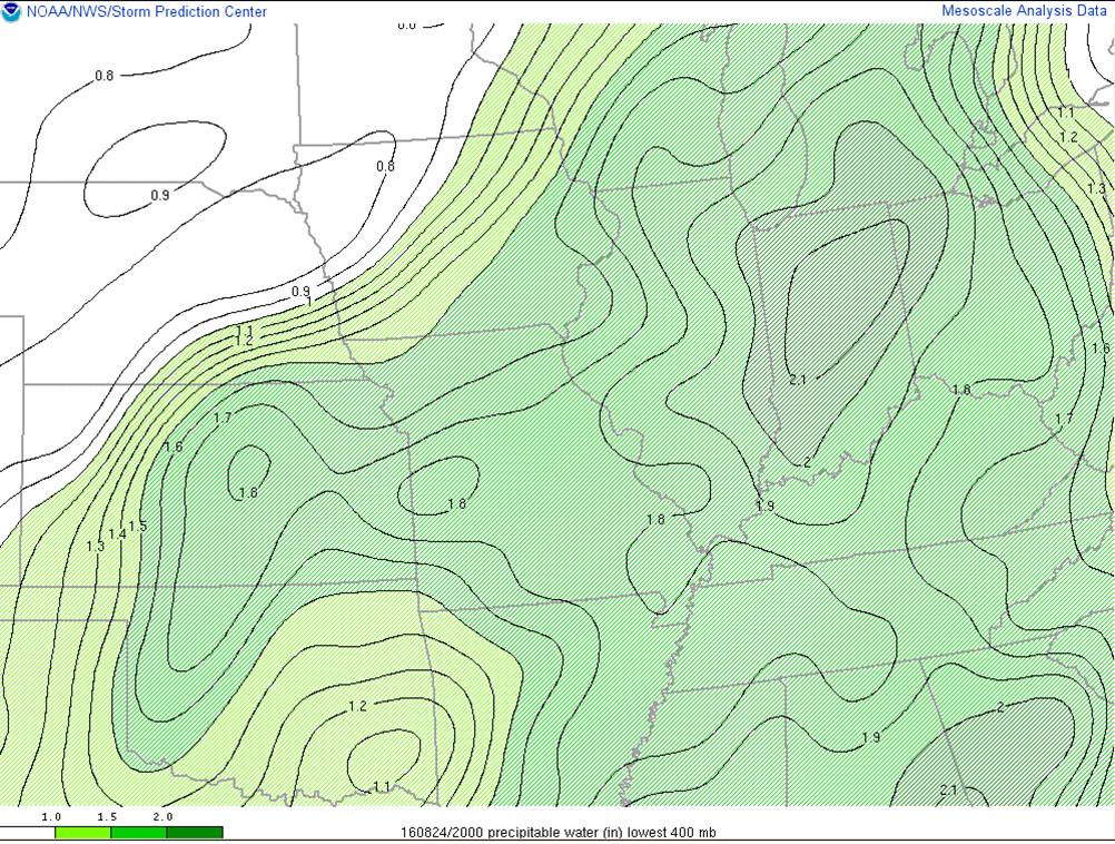 |
| Figure 1: 850 hPa: Moisture Transport: Vectors, heights, and theta-e at 5:00 PM EDT August 24th (Storm Prediction Center) | Figure 2: Lifted Condensation Level -Lower is generally more conducive to tornado development -at 4:00 PM EDT August 24th (Storm Prediction Center) | Figure 3: Precipitable Water (in)-4:00 PM EDT August 24th (Storm Prediction Center) |
Instability
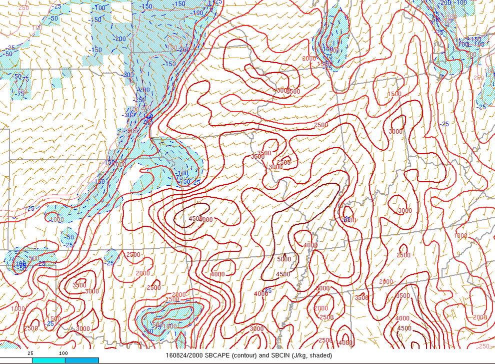
The more unstable an atmosphere is, the easier it is for air to rise. An unstable air mass is characterized by warm moist air near the surface and cold dry air aloft. When the sun heats the ground, there is warmer air at the surface than aloft. This creates instability. Below are some images of CAPE and Mid Level Lapse Rates-parameters we use to assess the instability during a given event. While there was a lot of cloud cover present on August 24th, the effects of the limited daytime heating combined with the abundant moisture lead to enough instability for severe storms to develop.
 |
 |
 |
| Figure 4: Surface Based CAPE (J/Kg)-A measure of Instability- 4:00 PM EDT August 24th (Storm Prediction Center) | Figure 5: Mixed Layer CAPE (J/kg)-A measure of instability in the mixed layer at 4:00 PM EDT August 24th (Storm Prediction Center) | Figure 6: Mid-Level Lapse Rates (C/Km) at 3:00 PM EDT August 24th (Storm Prediction Center) |
Lift/Triggers
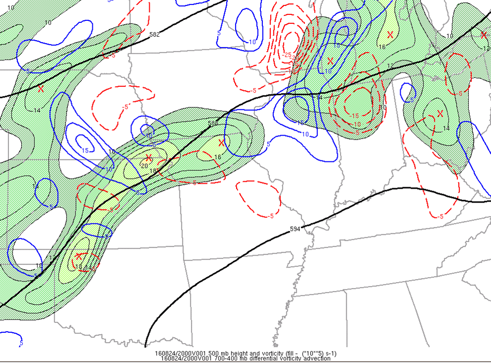
Storms also need some sort of trigger-or lift-to develop. This is something that would initiate upward movement of air. This occurs as a direct result of air density. Warm/moist air is less dense, so it rises over colder, drier air. Examples of lift would be frontal boundaries, lake breezes, outflow boundaries, and drylines. Our forecast area was east of an approaching cold front and an upper level disturbance. This helped to create enough upward motion to support stronger storms. Below are several parameters or fields that we analyze when assessing lift/triggers for storms.
 |
 |
 |
| Figure 7: 700-400mb Differential Vorticity Advection--Mid Level Lift at 4:00 PM EDT August 24th (Storm Prediction Center) | Figure 8: 300mb Jet Circulation, 700-500mb Omega, ageostrophic winds at 5:00 PM EDT August 24th (Storm Prediction Center) | Figure 9: Moisture Convergence and mixing ratio at 4:00 PM EDT August 24th (Storm Prediction Center) |
 |
 |
 |
| Figure 10: Surface Map-10:00 AM EDT August 24th (Weather Prediction Center Surface Map Archive) | Figure 11: Surface Map-5:00 PM EDT August 24th (Weather Prediction Center Surface Map Archive) | Figure 12: Surface Map-8:00 PM EDT August 24th (Weather Prediction Center Surface Map Archive) |
Wind Shear/Storm Relative Helicity
The most severe storms-supercells-need wind shear to rotate/spin. Wind shear is the change in wind direction and speed with height. For tornado development, stronger shear is better, especially if there is a lot of directional shear in the low levels. Below are some of the parameters or fields we look at to assess wind shear. During the event, the effective bulk shear peaked at about 40 knots (Fig. 13), which is strong enough for severe storms. Furthermore, 0-1 km shear was strong enough for tornado development. Storm Relative Helicity is another parameter that includes wind shear and instability in it's calculation. Values of 200-300 m2/s2 are sufficient for more significant tornadoes. At 4:00 PM EDT, the SRH where we had most of our tornadoes was 200-300 m2/s2.
 |
 |
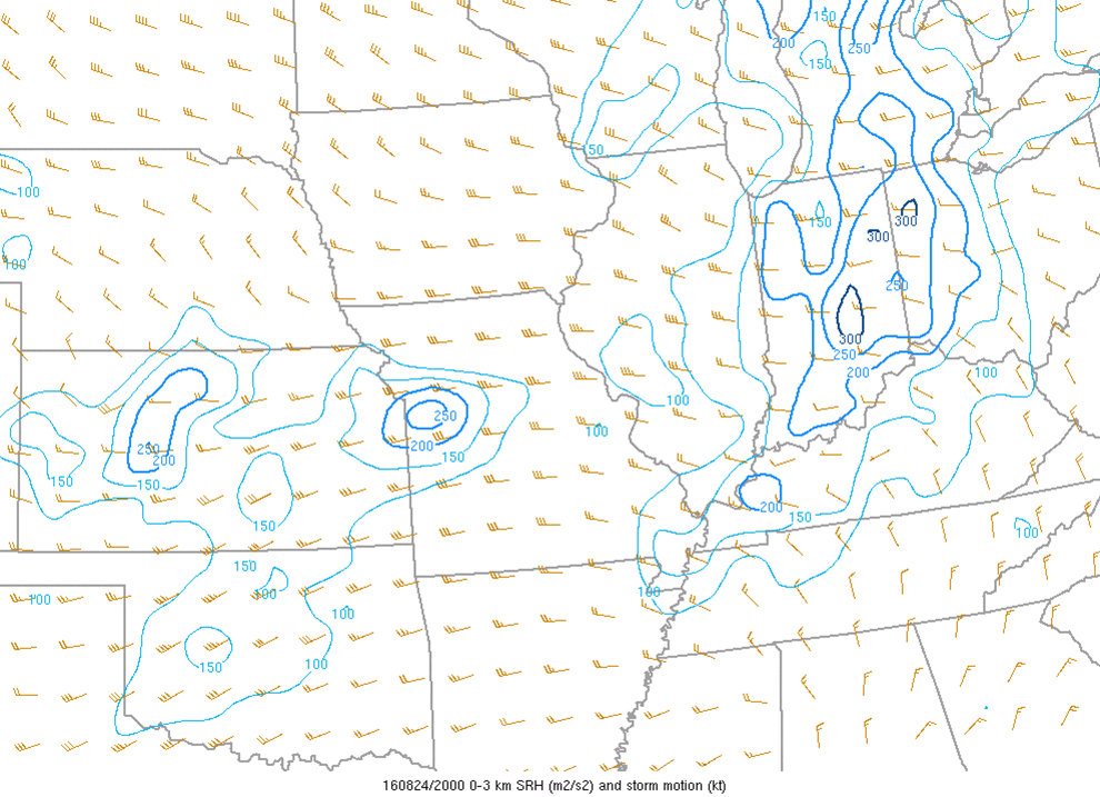 |
| Figure 13: Effective Bulk Shear (kt) at 4:00 PM EDT August 24th (Storm Prediction Center) | Figure 14: 0-1 km Shear Vector (kt) at 5:00 PM EDT August 24th (Storm Prediction Center) | Figure 15: Storm Relative Helicity(m2/s2) and Storm Motion(kt). Measure of the potential for cyclonic updraft motion in right-moving supercells at 4:00 PM EDT August 24th (Storm Prediction Center) |
Upper Air Maps: 300 hPa-700 hPa: 8:00 AM/PM EDT August 24, 2016
Below are the traditional upper air maps meteorologists analyze during events. In the maps below, you can see the upper level disturbance that provided a trigger for the storms, and the higher moisture levels that provided enough juice/instability for the storms.
 |
 |
 |
| Figure 16: 250 hPa Map -8:00 AM EDT Aug 24th (Storm Prediction Center) | Figure 17: 500 hPa Map -8:00 AM EDT Aug 24th (Storm Prediction Center) | Figure 18: 700 hPa Map -8:00 AM EDT Aug 24th (Storm Prediction Center) |
 |
 |
 |
| Figure 19: 250 hPa Map -8:00 PM EDT Aug 24th (Storm Prediction Center) | Figure 20: 500 hPa Map -8:00 PM EDT Aug 24th (Storm Prediction Center) | Figure 21: 700 hPa Map -8:00 PM EDT Aug 24th (Storm Prediction Center) |
Upper Air Maps: 850 hPa: 8:00 AM/PM, 925 hPa: 8 PM EDT: August 24th, 2016
 |
 |
 |
| Figure 22: 850 hPa Map -8:00 AM EDT Aug 24th (Storm Prediction Center) | Figure 23: 850 hPa Map -8:00 PM EDT Aug 24th (Storm Prediction Center) | Figure 24: 925 hPa Map -8:00 PM EDT Aug 24th (Storm Prediction Center) |
Additional Information
Storm Prediction Center Outlooks
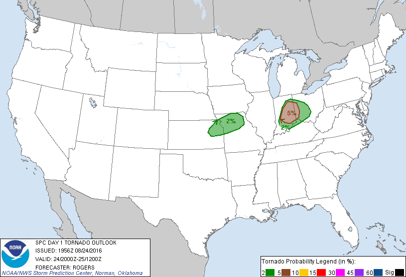
The Storm Prediction Center (SPC) had the IWX forecast area in a marginal risk for severe weather in their day 1 outlook initially (Figure 1), then upgraded to slight risk as environmental conditions became more favorable for severe weather (Figures 2 and 3). Damaging wind gusts were originally thought to be the primary threat, but as the environment became more favorable for tornadic supercells they issued an update to their tornado outlook at 4 pm EDT (Figures 5 and 6).
 |
 |
 |
| Figure 1. SPC Day 1 Outlook: Issued at 8:00 AM EDT 8/24/16, Valid 8:00 AM 8/24-8:00 AM 8/25 | Figure 2. SPC Day 1 Outlook: Issued at 12:30 PM EDT 8/24/16, Valid 12:30 PM 8/24-8:00 AM 8/25 | Figure 3. SPC Day 1 Outlook: Issued at 3:56 PM EDT 8/24/16, Valid 4:00 PM 8/24-8:00 AM 8/25 |
Figure 4. SPC Severe Weather Outlook Legend for reference
 |
 |
 |
| Figure 5. SPC Day 1 Tornado Outlook: Issued at 12:19 PM EDT 8/24/16, Valid 12:30 PM 8/24 -8 AM 8/25 | Figure 6. SPC Day 1 Tornado Outlook: Issued at 3:56 PM EDT 8/24/16, Valid 4:00 PM 8/24 -8 AM 8/25 | Figure 7. SPC Day 1 WIND Outlook: Issued at 3:56 PM EDT 8/24/16, Valid 4:00 PM 8/24 -8 AM 8/25 |
NWS IWX PRELIMINARY Warning Statistics
Statistics and Tornado Climatology Fun
During the August 24th, 2016 event we issued 26 tornado warnings and 2 severe thunderstorm warnings! Think that's a lot? See how that compares to the previous events in Table 1:
| No. of Tornado Warnings Issued During Event |
Event Date |
| 26 |
8/24/16 |
| 16 | 6/5/10 |
| 13 | 10/26/10 |
| 11 | 11/17/13 |
| 11 |
10/18/07 |
| 10 | 6/23/07 |
| 10 | 8/16/07 |
Table 1. Number of Tornado Warnings per Recent Events in the IWX CWA
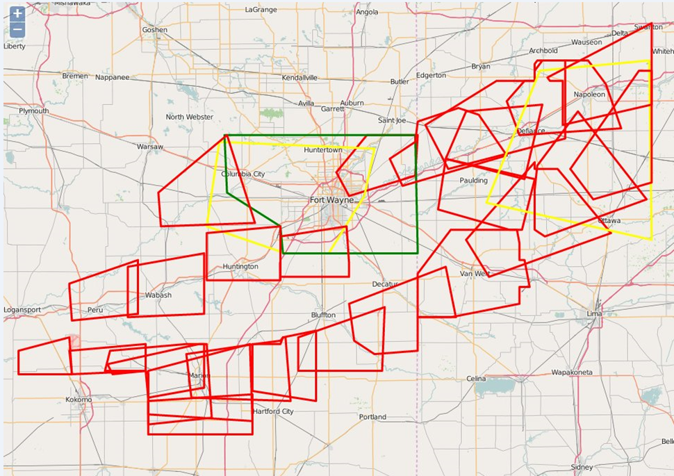
Figure 1. Severe Thunderstorm/Tornado Warnings and Areal Flood Advisory issued by IWX/IND August 24th, 2016
Previous Significant Tornadoes (IWX Forecast Area)
For more tornado and severe weather climatology, visit the Storm Prediction Center's Webpage
Event Summaries from other NWS Offices
 |
Media use of NWS Web News Stories is encouraged! Please acknowledge the NWS as the source of any news information accessed from this site. |
|


