Flooding in central and southern Indiana reached the highest 40, 50, or 90 years, depending on location. Following historic snowfall of up to 30 inches or more in southern Indiana during late December 2004, and a great ice storm in north central Indiana during early January 2005, upwards of nine inches or
more of rain fell in much of central Indiana. Total water amounts since December approached 12 inches for the four week period.
Columbus was almost completely cutoff from the rest of the state by flooded roadways by January 8. Meanwhile, later in the month, Western Vigo and Sullivan counties saw levees give way causing the flooding to spread several miles inland across rural farmland. 1,000 people were chased from their homes by the flooding. Other hard hit areas were Noblesville, Nora, Ravenswood, Spencer, Bedford, Petersburg, Clinton Shoals and Hazleton. The flooding also affected virtually all small streams across Central Indiana. The following photos are of the flooding along the Wabash River from West Terre Haute south to Merom Station. Click on a thumbnail to view a larger photo.
 |
 |
 |
 |
 |
 |
 |
 |
 |
 |
 |
 |
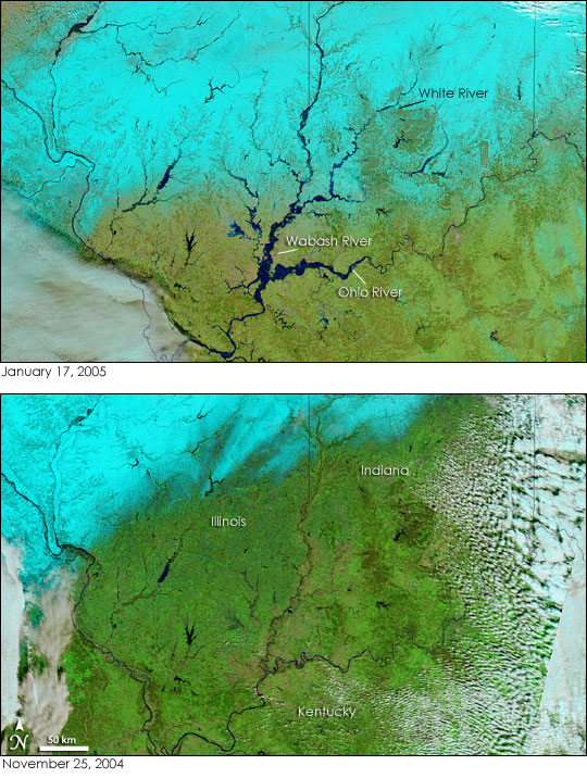
Below are NASA Satellite Images taken across Central and Southern Indiana on November 25, 2004 (prior to the flooding) and January 17, 2005. NASA images courtesy the MODIS Rapid Response Team at NASA GSFC.
 |
Please Take me back to the NWS Indy Home Page


 Follow us on YouTube