| Remembering the Snow Bowl - Ohio State vs. Michigan |
|
On November 25th, 1950, the Ohio State Buckeyes and Michigan Wolverines played in (arguably) the most legendary game of their storied rivalry. Called by some the "Snow Bowl", and by others the "Blizzard Bowl", it has a special place in the annals of football history not for the quality of the football being played, nor for the big names on the field, but for the weather, as the game was played in a significant blizzard unlike any that either school had played in before, or since. In fact, the severity of the weather led to football futility, as the combination of snow, wind, and cold minimized any threat for meaningful offense.
|
|
Both schools found it very difficult to move the ball, and a punt-fest ensued, with Michigan winning the game 9-3 without ever earning a first down. Michigan never completed a pass. They punted 24 times, almost more than their total offensive ouput for the game...27 yards. Ohio State punted 21 times, getting four of them blocked by the Wolverines. All of the scoring came as a result of those blocked kicks, with Ohio State blocking a punt that led to a field goal, and two of Michigan's blocked kicks leading to a safety and a touchdown.
|
|
It's hard to imagine in today's game of football, offensive ineptness to that degree. It speaks to the severity of the storm, the remarkable conditions, and just how debilitating extreme weather can be.
|
|
There are remarkable stories surrounding this game (detailed via the links and references below), but the meteorology is equally as remarkable given the weather football is typically played in.
|
|
An analysis of hourly observations from KCMH (Port Columbus Airport, a few miles east of Ohio Stadium on The Ohio State University campus), during the afternoon hours is below. It is important to remember that the wind speeds listed below are only sustained wind speeds, gusts were reported to be in excess of 35 mph during the game and most of the storm, which led to considerable blowing and drifting of the snow.
|
| Time (EST) |
Air Temperature (F) |
Sustained Wind (mph) |
Wind Chill** (F) |
Visibility (mi) |
Weather |
| Noon |
10 |
18 |
-8 |
1/2 |
Snow & Blowing Snow |
| 1 PM |
12 |
17 |
-5 |
1/4 |
Snow & Blowing Snow |
| 2 PM |
13 |
17 |
-4 |
1/3 |
Snow & Blowing Snow |
| 3 PM |
14 |
22 |
-4 |
1/2 |
Snow & Blowing Snow |
| 4 PM |
16 |
20 |
-1 |
1/4 |
Snow & Blowing Snow |
|
But it wasn't the game conditions themseleves as how much the conditions changed leading up to the game from Friday into Saturday.
|
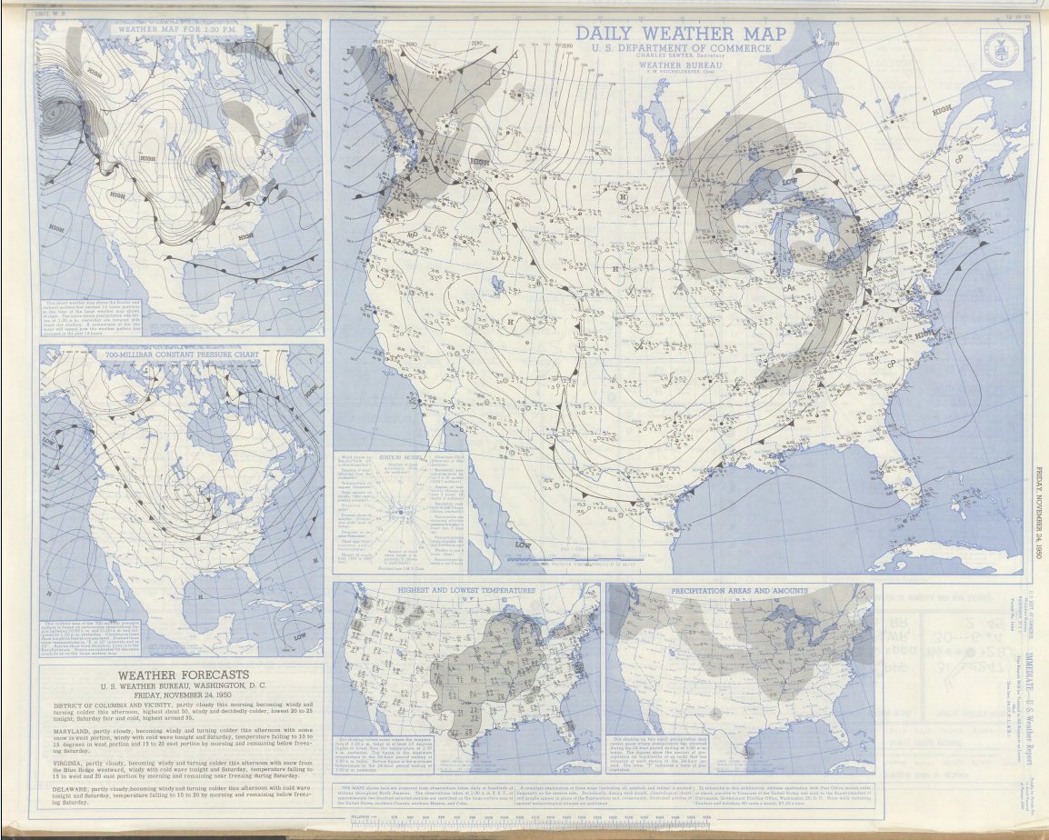
Friday November 24th 1950 Weather Map
|
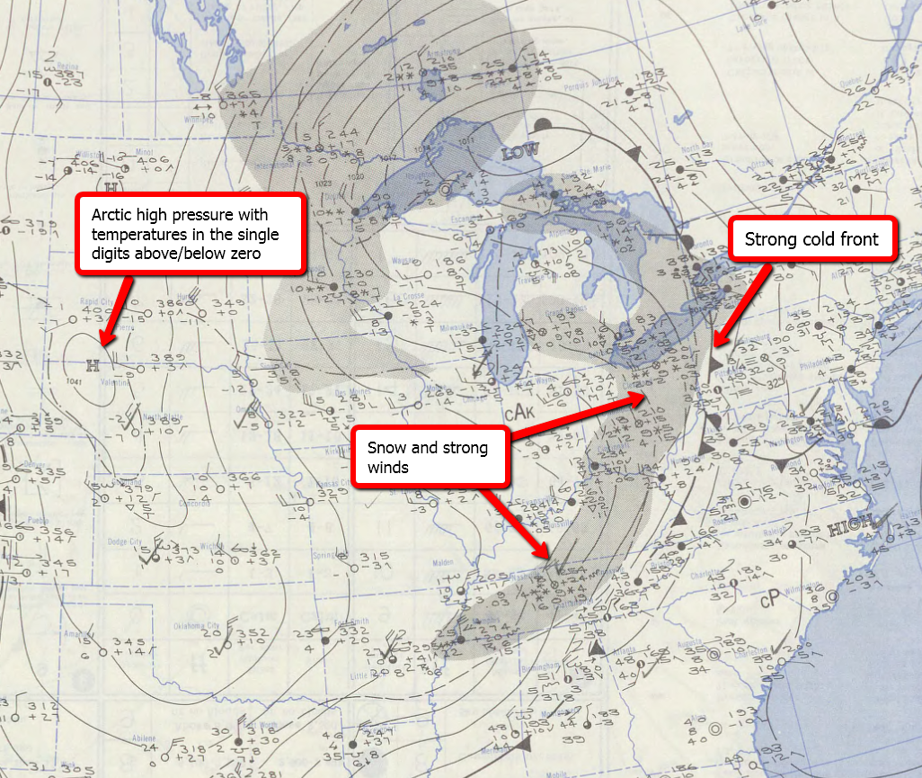
On Thursday night, cold air poured into the Great Lakes as a cold front moved through with snow, gusty winds, and falling temperatures. In fact, temperatures fell from 39 degrees in Columbus at 8 PM EST on Thursday evening, to 20 (F) by midnight. By 7 AM EST Friday morning, temperatures in Columbus were 8 (F) above zero with snow whipping across the Buckeye State. Between Thursday night and Friday, 2.3 inches of snow fell on the city of Columbus. Temperatures on Friday only rebounded to 11 (F) during the afternoon. The weather pattern is detailed in the Daily Weather Map (below) from Friday afternoon, November 24th. You may click on the map for a larger, high resolution view. In addition, an annotated zoom of the map is provided below:
|
|
|
|
|
Saturday November 25th 1950 Weather Map
|
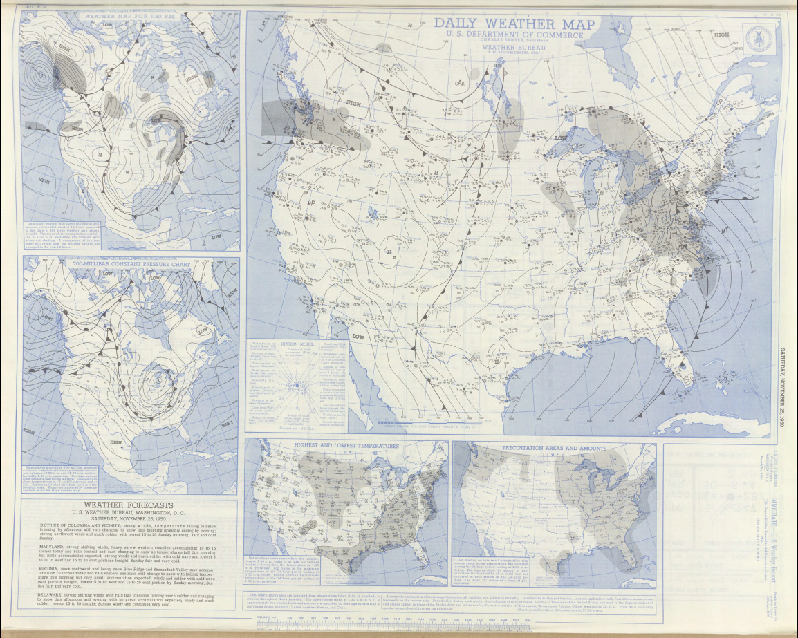
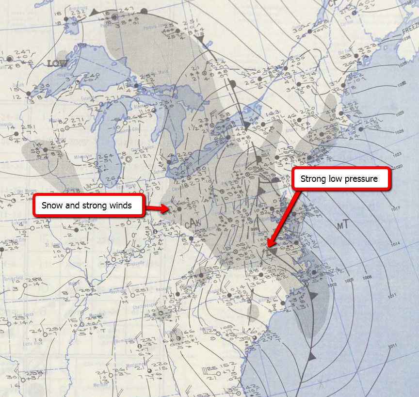
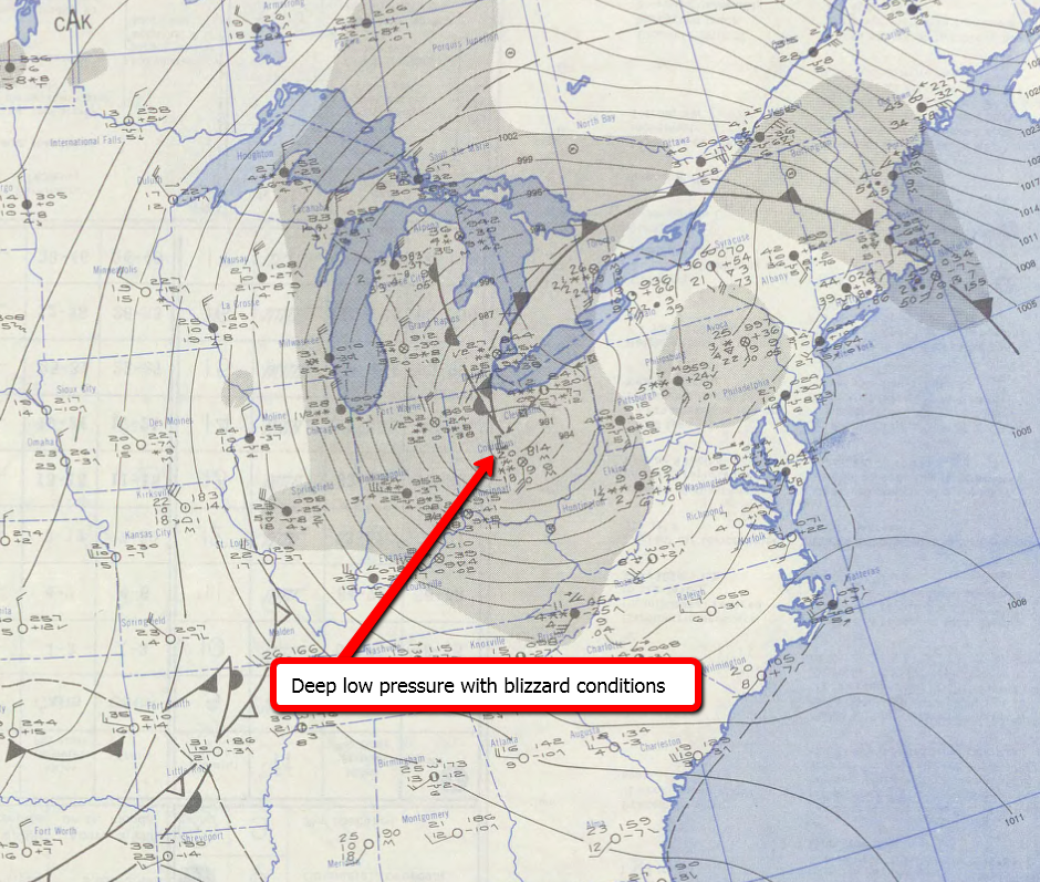
On Saturday, low pressure developed along the trailing frontal boundary in the southeast and rode northeast into the Mid-Atlantic and deepened considerably. The storm combined with the frigid arctic air moving across the Great Lakes to produce widespread heavy snow, strong winds, low wind chills, and near-whiteout conditions during the day. Another 7.5 inches of snow fell on Columbus on the 25th, creating virtually impossible travel conditions given the strong winds and blowing snow. The 7.5 inches of snow still stands as the greatest calendar day snowfall record for the month of November in Columbus, Ohio. The low pressure is seen in the detailed weather maps below. You may click on the map for a larger, high resolution view. In addition, an annotated zoom of the map is provided below:
|
|
|
|
|
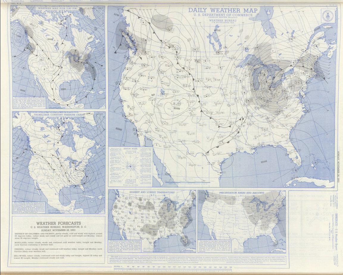
Sunday November 26th 1950 Weather Map
|
On Sunday, the storm reached maturity as it wrapped back westward into Ohio. Snow continued in an on and off fashion into Tuesday of the next week. All tolled, from Thursday night through Tuesday, 14.9 inches of snow fell on the city of Columbus. Portions of eastern Ohio received in excess of 20 inches of snow with much deeper drifts. It was one of the great November snowstorms in the history of Ohio. The 15.2 inches of snow that fell in Columbus in November of 1950 still stands as the greatest November total on record, and is the You may click on the map for a larger, high resolution view. In addition, an annotated zoom of the map is provided below:
|
|
|
|
|
References and Further Information
More information on the game and weather can be found here:
- Seth Binau, Science and Operations Officer (seth.binau@noaa.gov) |

