A very powerful low pressure system tracked out into the plains on Wednesday February 28th. Ahead of this system south winds transported an unusually moist airmass into Southeast Oklahoma, Eastern Kansas and Missouri.
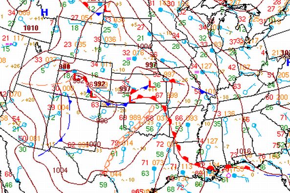 Surface chart from noon on February 28th. |
Storms erupted around 5 pm across Southeast Kansas. Ample low level moisture and strong upper level winds allowed the storms that developed to quickly become severe. Around 630pm one of the storms intensified into a supercell thunderstorm and shortly after started producing tornadoes. This is around the time the first tornado was reported with this storm in Woodson County. Shortly after this radar image, a spotter reported 3 tornadoes combining into one large wedge tornado.
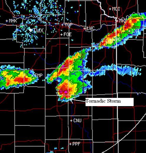 Radar image of the tornado producing supercell at 635 pm. |
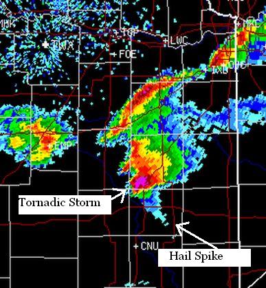 Radar image of this intense supercell as it moved out of Allen County and into Southern Anderson County. This image is from 652pm. |
Below are all of the severe weather reports from this early season severe weather outbreak:
PRELIMINARY LOCAL STORM REPORT...SUMMARY
NATIONAL WEATHER SERVICE WICHITA KS
137 AM CST THU MAR 01 2007

..TIME...   ...EVENT...      ...CITY LOCATION...     ...LAT.LON...
..DATE...   ....MAG....      ..COUNTY LOCATION..ST.. ...SOURCE....
            ..REMARKS..

0542 PM     HAIL             1 S EUREKA              37.81N 96.29W
02/28/2007  E1.00 INCH       GREENWOOD          KS   LAW ENFORCEMENT

0557 PM     HAIL             7 WNW YATES CENTER      37.91N 95.86W
02/28/2007  E1.00 INCH       WOODSON            KS   LAW ENFORCEMENT

0624 PM     TSTM WND GST     5 N YATES CENTER        37.94N 95.74W
02/28/2007  E70.00 MPH       WOODSON            KS   LAW ENFORCEMENT

0633 PM     TORNADO          12 NE YATES CENTER      38.00N 95.59W
02/28/2007                   WOODSON            KS   LAW ENFORCEMENT

            TWO SMALL ROPES REPORTED ON THE GROUND

0701 PM     TORNADO          6 N IOLA                38.01N 95.40W
02/28/2007                   ALLEN              KS   PUBLIC

0707 PM     TORNADO          7 N IOLA                38.03N 95.40W
02/28/2007                   ALLEN              KS   TRAINED SPOTTER

            3 TORNADOES COMBINED INTO 1 WEDGE

0915 PM     HAIL             8 E STRONG CITY         38.40N 96.39W
02/28/2007  E0.75 INCH       CHASE              KS   TRAINED SPOTTER

            HAIL COVERED THE GROUND.

0931 PM     HAIL             COTTONWOOD FALLS        38.37N 96.54W
02/28/2007  E0.75 INCH       CHASE              KS   TRAINED SPOTTER

            PENNY SIZE HAIL COVERED THE GROUND.
------------------------------------------------------------------------

