Wichita, Kansas
Weather Forecast Office
June 5th 2014 Overnight & Early Morning Severe Weather Outbreak
| A slow moving cold front moved south across south central and southeast Kansas on June 4, 2014 becoming stationary across Southern Kansas late in the day. A moist and unstable airmass north of the front extended west across the High Plains of western Kansas and eastern Colorado. Thunderstorms developed over northeast Colorado during the evening hours and raced southeast across Kansas during the overnight and early morning hours. Very large hail up to 3 inches in diameter, damaging winds in excess of 70 mph and locally heavy rain were reported across much of central, south central and southeast Kansas during the morning hours on 5 June 2014. |
|
Reports of Severe Hail and Wind on June 5th, 2014 Click for more information |
Radar animation showing the storms tracking across central and southeast Kansas early Thursday morning |
|
|
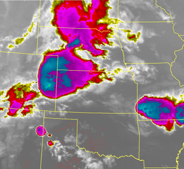
Satellite animation showing a mesoscale convective system moving eastward across the Central Plains. |
||
Hazards
Briefing pages
Local weather story
Submit a storm report
Storm Prediction Center
Enhanced Hazardous Weather Outlook
Current Conditions
Local Radar
National Radar
Satellite
Hourly weather(text)
Precip Analysis
Snowfall analysis
This day in weather history
Forecasts
Forecast Discussion
Weather Story
Fire Weather
Activity Planner
Aviation Weather
Soaring Forecast
Hurricane Center
Graphical Forecasts
Regional Weather Summary
Probabilistic Snow
Probabilistic QPF
Wet Bulb Globe temp
Climate
Local Climate Page
Daily/Monthly data(F6)
Daily Records
Climate Normals
Local drought page
Latest Climate Report(ICT)
Latest Climate Report(SLN)
Latest Climate Report(CNU)
CoCoRaHS
US Dept of Commerce
National Oceanic and Atmospheric Administration
National Weather Service
Wichita, Kansas
2142 S. Tyler Road
Wichita, KS 67209-3016
316-942-3102
Comments? Questions? Please Contact Us.


.png)