|
|
|

ESRI Shapefiles: 
All Survey Shapefiles - Zipped folder contains line, path, survey point, and select estimated damage swath shapefiles of all tornado tracks that occurred in the Huntsville County Warning Area. Attribute information includes: Tornado Name, EF-Scale, Peak Wind, Start Time, Beginning and Ending Latitudes and Longitudes, End Time, and maximum width in yards.
Jump to:
- Franklin/Colbert County (Crooked Oak), AL
- Morgan County (Neel), AL
- Cullman County (Helican to Nesmith), AL
- Madison/Jackson County (Monte Sano to Princeton), AL
- Jackson County (Estillfork), AL
- Cullman County (near Nesmith, AL
- Jackson County (Bryant), AL
- Marshall County (Union Grove), AL
- Jackson to DeKalb County (Rosalie to Ider), AL
- Jackson County (Allison), AL
|
|
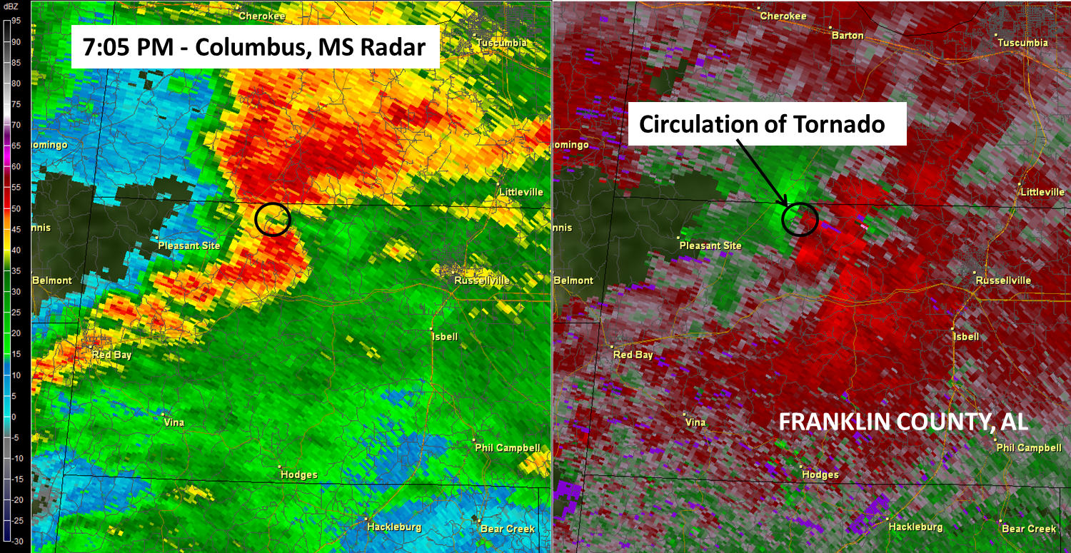
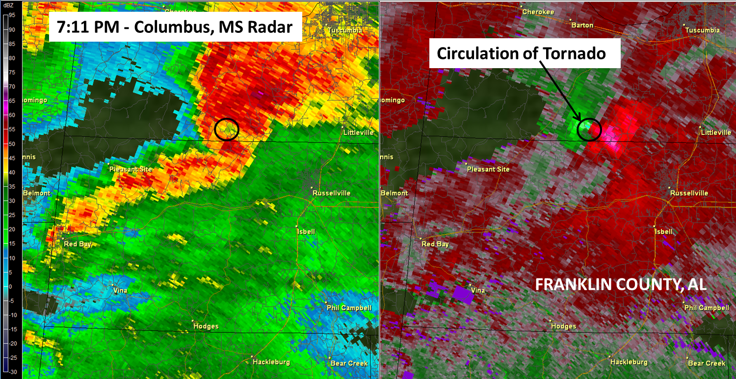
.Franklin-Colbert County Tornado...
|
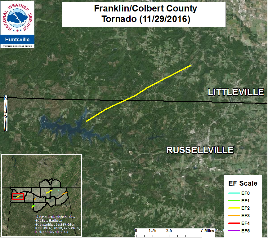 |
.Crooked Oak/Underwood/Frankfort (Franklin/Colbert County) Tornado...

Rating:                             EF-2
Estimated Peak Wind:      115 MPH
Path length /Statute/:        11 Miles
Path width /Maximum/:     100 Yards
Fatalities:                         0
Injuries:                            3

Start date:                        Nov 29 2016
Start time:                        705 PM CST
Start location:                   9 NNW Russellville
Start Lat/Lon:                   34.5415/-87.9038

End date:                        Nov 29 2016
End time:                        723 PM CST
End location:                   7 SSW Tuscumbia
End lat/lon:                     34.6272/-87.7439

Survey Summary:

A supercell crossed over northern Franklin County Alabama and a
tornado developed and touched down near Lost Creek Road on the
northeast side of the Cedar Creek Reservoir. When it touched down, a
number of hardwood trees, softwood trees, and power poles were
snapped and a well built single family home lost a significant amount
of the roofing material and the one occupant of the home was injured
when the tornado occurred. The home also shifted with cracks noted on
the concrete undergirding of the home. This is where the tornado was
at its strongest (EF-2). The tornado quickly moved northeast snapping
10-20 trees and power poles as it moved towards the Frankfort
Community along County Road 88.

After crossing into Colbert County, more softwood and hardwood trees
were snapped causing damage to a single wide manufactured home and
car shed on Jones Road. More softwood and hardwood trees were snapped
as the tornado continued northeast across County Road 49. Then,
as the tornado continued to move northeast multiple softwood and
hardwood trees were snapped close to Underwood Mountain Road before
striking a single wide manufactured home. The single wide
manufactured home sustained damage consistent with EF-1 rating with
destruction of roof and walls leaving floor and undercarriage in
place. Two people within this home sustained injuries. Another single
family dwelling next to this manufactured home sustained damage
uplift of the roof damage while more snapped hardwood trees were
noted just to the northeast of these houses. This is also where the
tornado had the largest width of 100 yards. The tornado then lifted
shortly after this damage occurred.
|
| Radar |
 |
 |
| |
|
|
Return to Top of Page
|
|
|
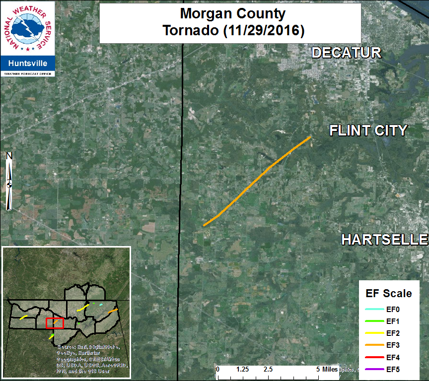
.Morgan County Tornado...
|
.Morgan County/Neel Tornado...

Rating:                            EF-3
Estimated Peak Wind:     140 MPH
Path length /Statute/:       6.2 Miles
Path width /Maximum/:    175 Yards
Fatalities:                        0
Injuries:                           0

Start date:                       Nov 29 2016
Start time:                       840 PM CST
Start location:                  Danville Road east of Isabel Mountain
Start Lat/Lon:                  34.44058/-87.09132

End date:                        Nov 29 2016
End time:                        848 PM CST
End location:                   Herring Road south of Sunset Drive
End Lat/Lon:                   34.50427/-87.01466

Survey Summary: The tornado first touched down along Danville
Road just east of the Lawrence County line. In this area, trees
were snapped and uprooted. Minor damage was noted to a shed here.
The tornado then moved northeast and strengthened as it crossed
the intersection of Maddox Road and Johnson Chapel Road. Here
hardwood trees were snapped near the base and a home suffered
significant roof and structural damage.

Along northwest Maddox Road several homes sustained significant
structural damage. One home had the roof and a large section
of the wall blown out. The residents of the home rode the storm
out safely in the interior most hallway. Several power poles were
snapped at the base. Damage here was consistent with very high
end EF-2 damage.

The tornado once again crossed Danville Road causing structural
damage to several buildings including a multi-story home. Significant
roof uplift was noted in this location. A large industrial garage
in this area was also destroyed. A convenience store nearby suffered
damage, and the owner`s family received warning alerts and took
shelter in an interior hallway to ride out the storm.

The tornado then approached Neel School Road causing significant
damage in and around the Neel Volunteer Fire Department. The roof
was nearly completely taken off the fire department and large metal
trusses were bent at this facility. A nearby large building was
obliterated and other well built structure had its roof and supports
taken off.

As the tornado moved northeast, it cross Singleton Road impacting more
structures. Several homes sustained structural damage, mainly roof
damage. One very large building was completely destroyed with another
sustaining near collapse. The tornado then reached its maximum intensity
as it crossed Boys Ranch Road on the eastern edge of Bogar Loop.

Here a home suffered complete roof loss and partial wall collapse. An
anchored mobile home was obliterated with the contents thrown over 100
yards. A motor cycle repair shop that included an anchor bolted large
shop building was nearly wiped clean with motorcycles thrown or rolled
large distances. An SUV parked here was thrown and then rolled about
75 yards. Damage here was consistent with lower end EF-3 damage at
140 mph.

The tornado then crossed mostly rugged, hilly and rural terrain downing
trees as it began to slowly wind down in intensity. The tornado then
once again crossed Danville Road north of McCleskey producing widespread
tree damage. Here very large hardwood trees were snapped near the based
and uprooted. A home here sustained damage to the roof and also damage
due to falling trees. A large shed/outbuilding here was destroyed.

As the tornado crossed Herring Road it produced damage to a roof on a
conventional home and also significant roof and strucutural damage to
a mobile home. On the northeast side of Herring Road minor tree damage
was noted as the tornado finally lifted.
Return to Top of Page
|
|
|
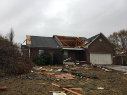
.Cullman County (Helicon to Nesmith, AL)...
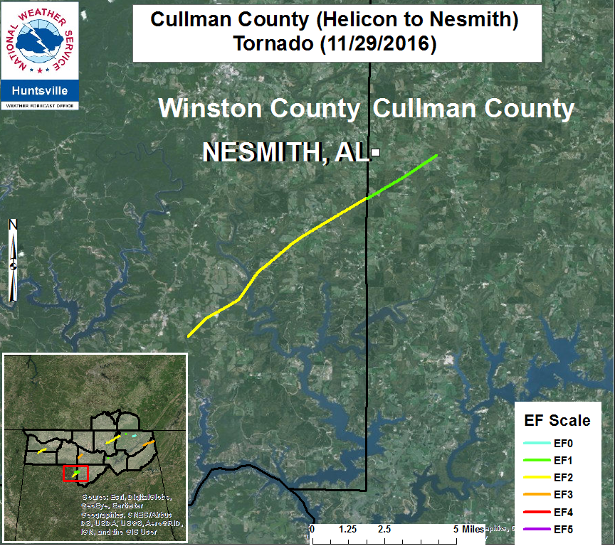
.Cullman County (Helican/Ne Smith) Tornado...
Rating:                          EF-1
Estimated Peak Wind:    95 MPH
Path length /Statute/:      2.4 Miles
Path width /Maximum/:   TBD
Fatalities:                       0
Injuries:                          0

Start date:                     Nov 29 2016
Start time:                     905 PM CST
Start location:                2 ENE Helicon
Start Lat/Lon:                34.1394 / -87.1117

End date:                      Nov 29 2016
End time:                      907 PM CST
End location:                 2 ESE Nesmith
End_lat/lon:                  34.1604 / -87.0781

Survey Summary:
This tornado was originally the Arley/Helicon EF-2
tornado that originated in Winston County (WFO Birmingham). It
continued across County Road 986, causing significant damage to a
barn and snapping several hardwood and softwood trees. The tornado
continued northeast, continued to snap trees and destroyed another
shed as it crossed CR 946 and 939. It appeared to lift northeast of
CR 939.

Thanks to WFO Birmingham for their assistance with this survey.
Return to Top of Page
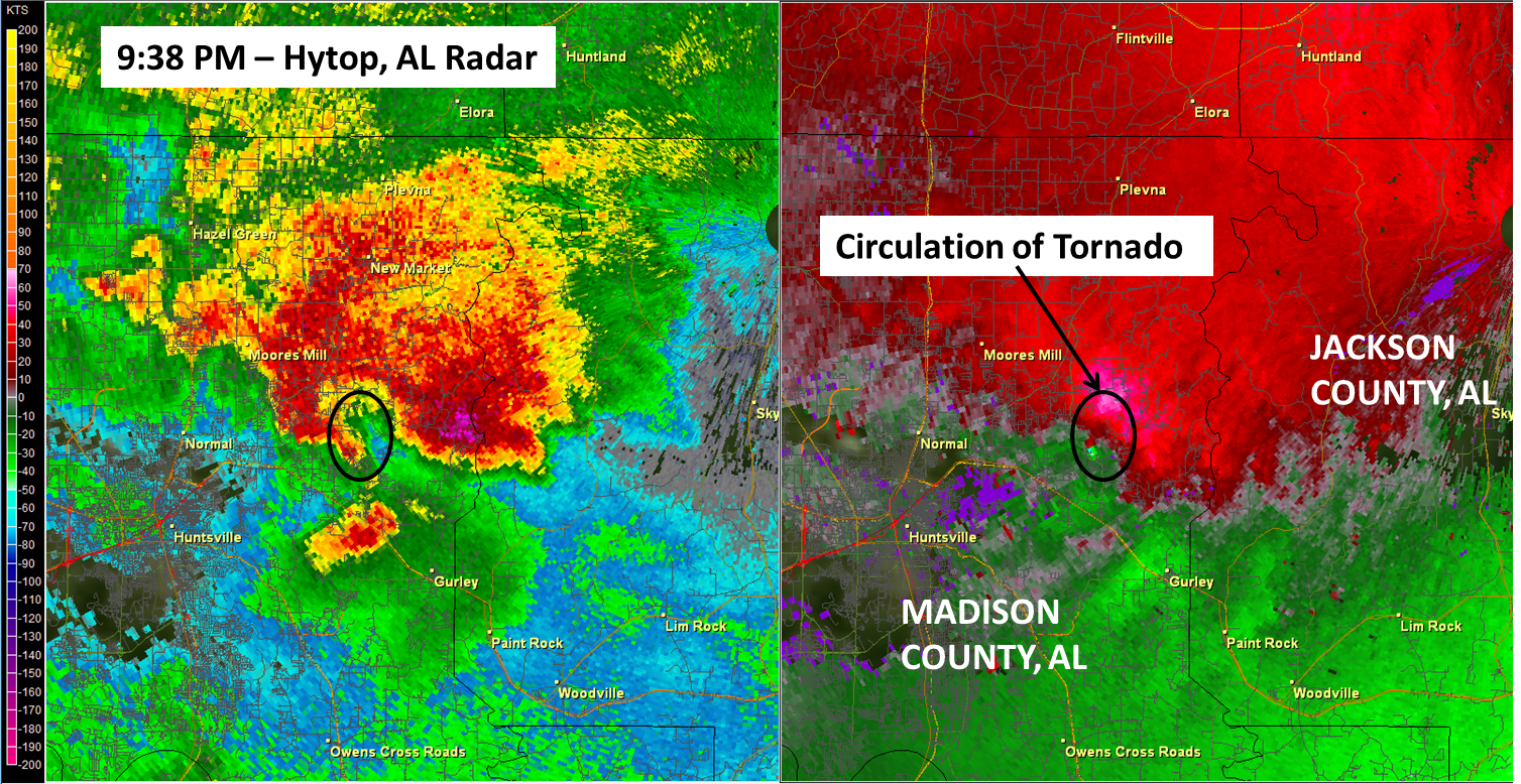
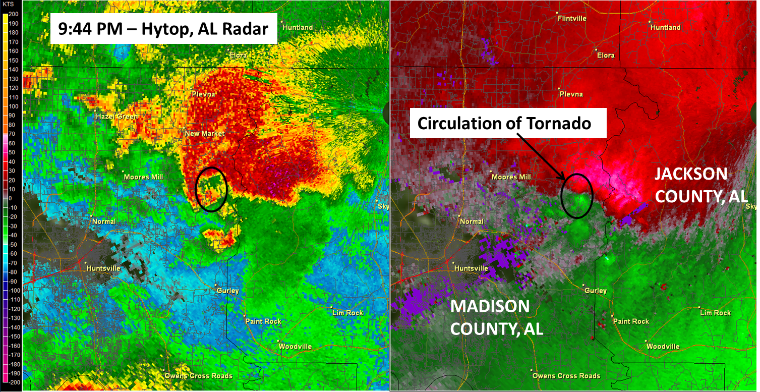
.Madison-Jackson County Tornado...
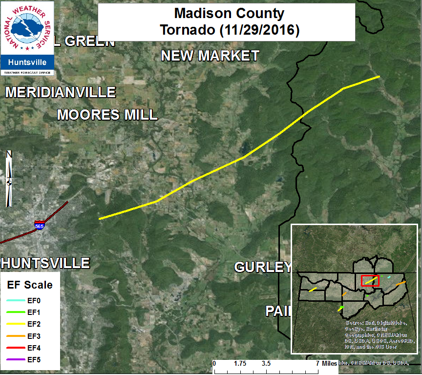
|
|
.Monte Sano/Ryland/Maysville/Princeton Tornado...

Rating:                             EF-2
Estimated Peak Wind:      125 MPH
Path length /Statute/:        19.9 Miles
Path width /Maximum/:     150 Yards
Fatalities:                         0
Injuries:                            0

Start date:                       Nov 29 2016
Start time:                       929 PM CST
Start location:                  3 ENE Huntsville (Monte Sano)
Start Lat/Lon:                  34.74 / -86.53

End date:                        Nov 29 2016
End time:                        1000 PM CST
End location:                   3 N Princeton
End lat/lon:                     34.89 / -86.24

Survey Summary:
Initial continuous damage was found along the leading edge of Monte
Sano Mountain close to the intersection of Monte Sano Blvd. and Nolan
Avenue. Several trees were snapped and uprooted as it moved along the
northern brow of the mountain. A clear, continuous path of snapped
trees was observed just north of the RV campground area of Monte
Sano State Park. From here, the tornado skipped down the northeast face
of the mountain, caused minor tree damage near Wall Road, US Highway
72, and Morring Road.

More significant damage resumed near Ryland Pike near its intersection
with Delta Pine Dr. Trees were snapped on Ryland Pike, then the
tornado entered the Central Estates neighborhood. At least 15 houses
had at least some roof decking removed in the neighborhood. A few
houses had large sections of the roof structure removed, including
one house on Moontown Road which had its entire roof and roof
structure removed. Elsewhere around the neighborhood, many more
houses had at least superficial damage to fascias and gutters, or had
privacy fencing blown away.

The Flint Ridge horse farm suffered significant damage. Nearly all
of the tin roofing was removed from one large and one small horse
barn, and a riding arena was completely destroyed. Nearly all of the
trees within 50-75 yards of the farm buildings were snapped. The
tornado was clearly at its strongest between the house that lost all
roofing, and the horse farm damage. At this location, the peak
intensity is set at 125 MPH, an EF-2 on the Enhanced Fujita scale.

The tornado continued over a nearby ridge and weakened slightly,
snapping and uprooting more trees along Hurricane Creek Road, Sharps
Cove Road, and Neal Drive. Additional damage to houses was noted
along Sharps Cove and Neal Drive, where roofing was peeled off a
manufactured home and nearby single family home.

Little additional damage was noted later along Sharps Cove Road near
the Madison-Jackson County line, or in the surrounding hillsides.
The end point is set on the ridge line west of Sharps Cove Road.
Damage Photos
Return to Top of Page
|
|
|
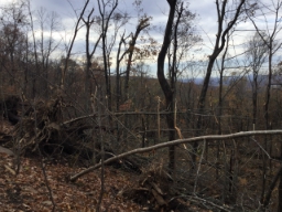
.Jackson County (Estillfork)...
.png)
.Jackson County (Estillfork) Tornado...
Rating:                          EF-1
Estimated Peak Wind:    95 MPH
Path length /Statute/:      0.9 Miles
Path width /Maximum/:   40 Yards
Fatalities:                       0
Injuries:                          0

Start date:                     Nov 29 2016
Start time:                     1002 PM CST
Start location:                4 W Hytop
Start Lat/Lon:                34.92 / -86.14

End date:                      Nov 29 2016
End time:                     1007 PM CST
End location:                3 W Hytop
End_lat/lon:                  34.92 / -86.13

Survey Summary:
The parent supercell thunderstorm that produced the Monte Sano EF-2
tornado also produced a separate area of rotation that caused
the EF-1 Estillfork tornado. The NWS and UAH survey found significant
softwood tree damage in the form of healthy and snapped pine trees
along CR-9, east of the CR-9 and CR-141 intersection. The convergence
of the down trees was evident at several locations along CR-9
and in the Estillfork area. Peak winds were determined to be 95 MPH.
Return to Top of Page
|
|
|
.Cullman County (near Nesmith, AL)...
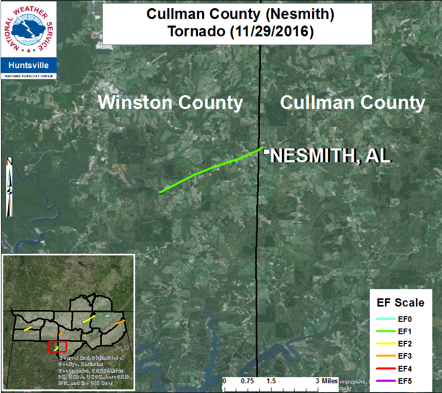
.Cullman County (Nesmith) Tornado...


Rating:                             EF-1
Estimated Peak Wind:      100 MPH
Path length /Statute/:        350 Yards
Path width /Maximum/:      50 Yards
Fatalities:                          0
Injuries:                             0

Start date:                         Nov 29 2016
Start time:                         1025 PM CST
Start location:                    near Nesmith AL
Start Lat/Lon:                    34.1745/-87.1109

End date:                          Nov 29 2016
End time:                          1026 PM CST
End location:                     near Nesmith AL
End lat/lon:                       34.1760/-87.1089

Survey Summary:

Note: This is the continuation of a tornado that started in Winston
County, Alabama

The tornado that began in Winston County producing EF-1 damage
continued into NW Cullman County near Ne Smith, AL where multiple
hardwood and softwood trees were snapped as it moved towards a
storage shed building on County Road 1024.

As it moved towards the small building the tornado uplifted the roof
of the building causing the walls collapse and sending debris across a
field. Then, as the tornado proceeded northeast it uplifted the metal
roof on another single family building. This damage was consistent
with EF-1 intensity and was the strongest damage with this portion
of the tornado track. More trees were snapped just to the northeast
of this position on County Road 1024 near another single family home
before it lifted.
Return to Top of Page
|
|
|
.Jackson County (Bryant)...
|
|
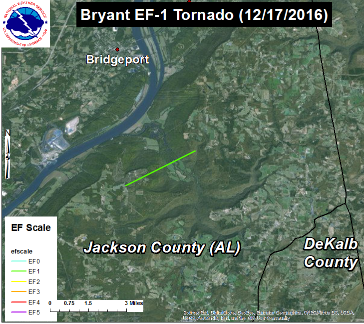
.Bryant (Jackson County) Tornado...
.Bryant Tornado...

Rating:                   EF-1
Estimated Peak Wind:      88 MPH
Path length /Statute/:    2.31 Miles
Path width /Maximum/:     150 Yards
Fatalities:               0
Injuries:                 0

Start date:               Nov. 29 2016
Start time:               1100 PM CST
Start location:           7SW Bryant
Start Lat/Lon:            34.87 / -85.71

End date:                 Nov. 29 2016
End time:                 1103 PM CST
End location:             6S Bryant
End_lat/lon:              34.89 / -85.67

Survey Summary:
Update to the Nov. 29/30 outbreak:
A survey team from the University of Alabama-Huntsville
(UAH) relayed reports of damage and geocoded photographs along
CR-690, south of Bryant, AL (Jackson County). NWS Huntsville,
after coordination with UAH and investigation of the photos and
radar data, determined the damage was associated with a weak
EF-1 tornado.

The bulk of the damage was generally observed along CR-690, between
CR-691 and CR-676. Damage indicators were limited to snapped soft
wood trees and/or snapped large branches. While the majority of the
damage was indicative of an EF-0 tornado, there was a small path
of EF-1 damage just to the west of CR-676. In this area, several
healthy softwood trees were snapped before the tornado weakened as it
approached a ridge on the east side of CR-676.
Return to Top of Page
|
|
|
.Marshall County (Union Grove)...
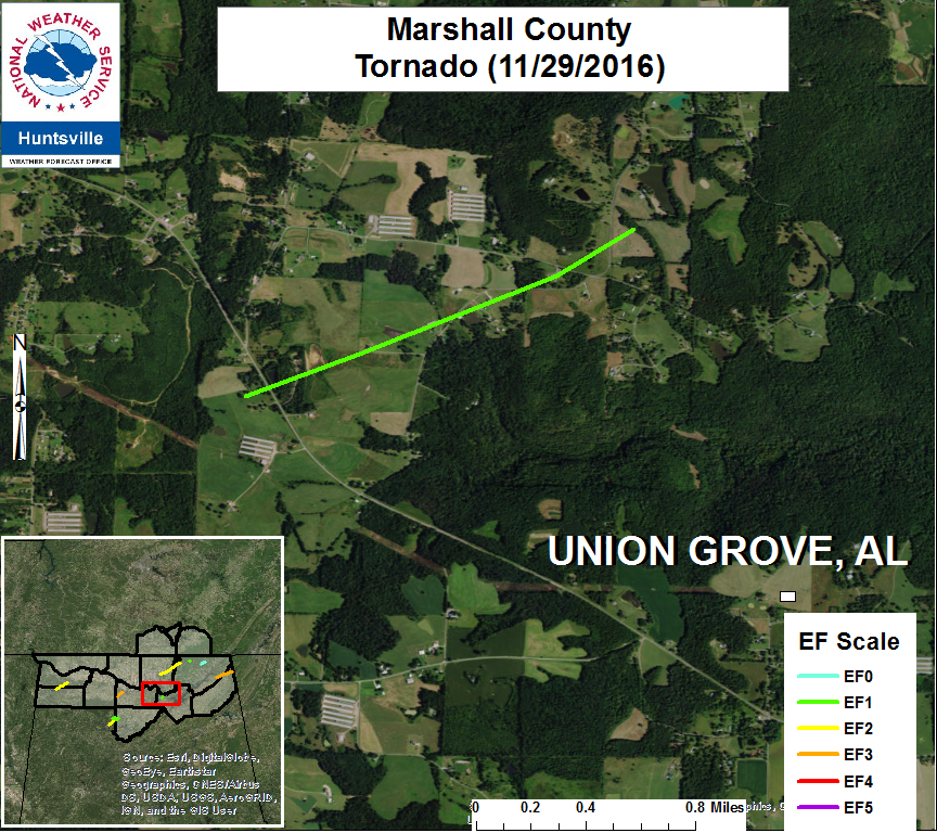
.Union Grove (Marshall County) Tornado...
Rating:                            EF-1
Estimated Peak Wind:     100 MPH
Path length /Statute/:       1.2 Miles
Path width /Maximum/:     50 Yards
Fatalities:                         0
Injuries:                            0

Start date:                       Nov 29 2016
Start time:                       1105 PM CST
Start location:                  3 NW Union Grove
Start Lat/Lon:                  34.4315/-86.5032

End date:                        Nov 29 2016
End time:                        1111 PM CST
End location:                   3 NW Union Grove
End lat/lon:                     34.4403/-86.4828

Survey Summary:

A tornado developed near Union Grove Road and Tinner Mayo road
intersection in the Union Grove Community. As it developed multiple
trees were snapped and uprooted causing minor roof damage to one
single family home. More significant home damage was sustained to
another nearby single family house due to trees snapping and falling
on the roof.

As the tornado proceeded northeast to Tinner Mayo Road, it flipped a
recreational vehicle and moved it into a single family home causing
damage to the home and destroying the recreational vehicle.
Meanwhile, the tornado caused shingles to come off the roof of this
single family house. Further to the northeast, the tornado uplifted
the roof of a storage shed for hay and caused minor roof damage to a
double wide manufactured home.

More damage was sustained to a single family dwelling near Tinner-
Mayo and Brock Chapel road as the tornado continued northeast where
the roof was completely uplifted and blown into the field. The
tornado then snapped a few more hardwood trees before lifting just
northeast of Bean Rock Road.
Return to Top of Page
|
|
|
.Jackson to DeKalb County (Rosalie to Ider)...
|
.Rosalie/Ider (Jackson/Dekalb County) Tornado...
Rating: EF-3
Estimated Peak Wind: 145 MPH
Path length /Statute/: 13.7 Miles
Path width /Maximum/: 206 Yards
Fatalities: 3
Injuries: 10
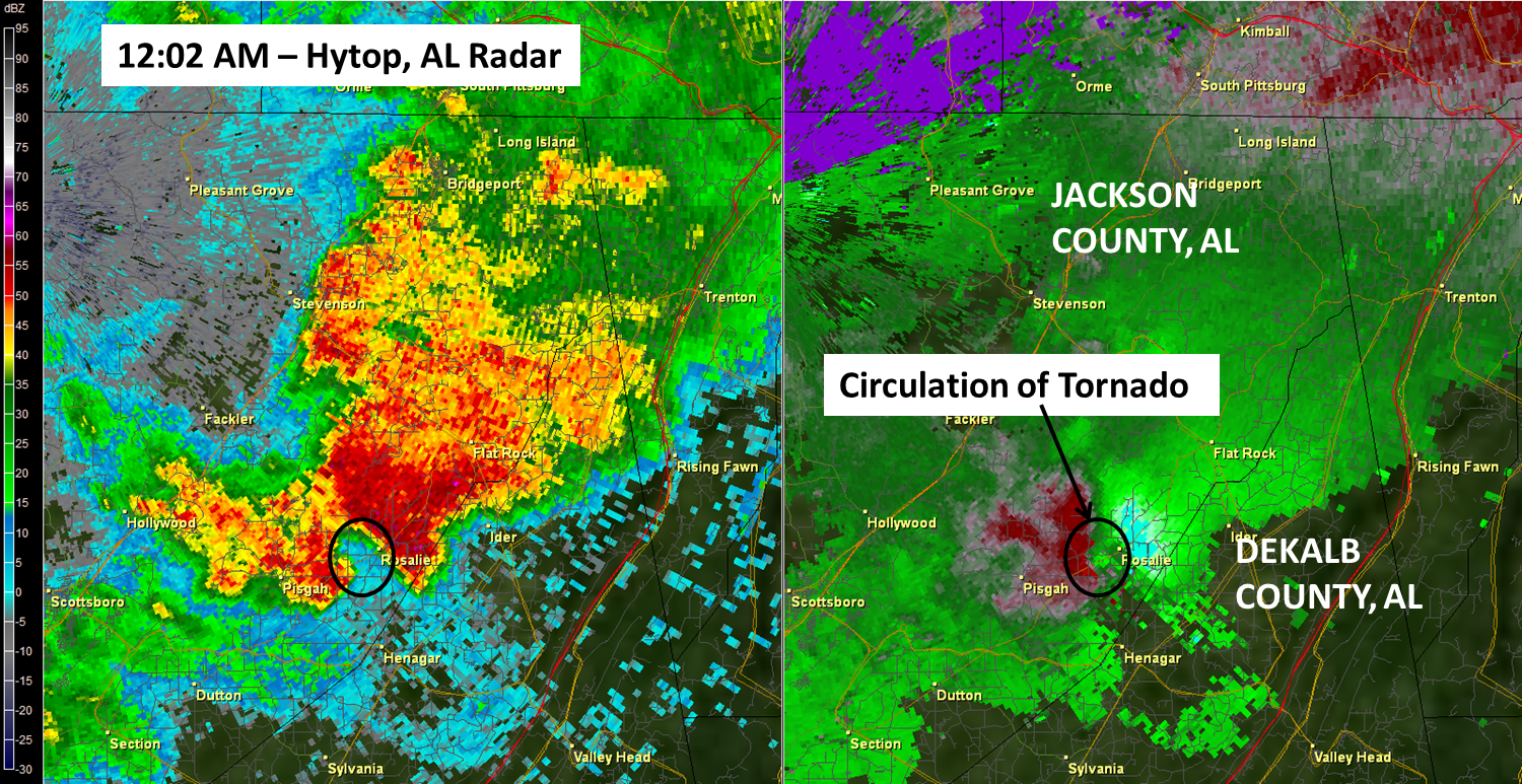
Start date: Nov 30 2016
Start time: 1202 AM CST
Start location: 4 ENE Pisgah
Start Lat/Lon: 35.69 / -85.78
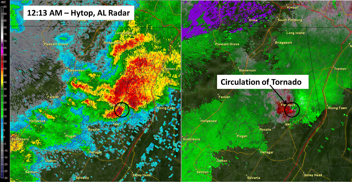
End date: Nov 30 2016
End time: 1220 AM CST
End location: 10 NNW Ider
End_lat/lon: 34.78 / -85.57
Survey Summary:
12/1/2016 Update:
The supplemental survey of the Rosalie/Ider Tornado determined that the tornado
was one continuous track from the southern Rosalie area to the AL/GA state line.
The 13.7 mile long track observed peak winds of 145 mph (EF-3) near Ider with
generally EF-2 and EF-1 damage observed elsewhere on the track.
A new start point was observed approx. one half mile to the SSW of the previous point.
Minor roof damage to a structure and a snapped power line indicated that the
tornado was about 100 MPH (EF-1) at the touch down.
The assessment team was able to connect the previous Rosalie track to the Ider
track after observing significant roof damage to single family home with complete
destruction to a barn on the property near the intersection of CR-345 and CR-78.
Additional points were added along CR-330 to CR-117 (DeKalb Co.) after the team recorded
snapped softwood and hardwood trees and damage to a large anchored shed.
Between CR-117 and AL-75 in DeKalb County, numerous chicken farms were completely
destroyed along. Several homes in the area sustained significant roof damage and two
anchored mobiles homes were observed to have rolled. One unanchored mobile home was
completely destroyed with scattered debris.
Finally, the team traveled along CR-792 in the Deer Head Cove area (near the AL/GA
state line) and observed complete destruction to a well anchored and large metal
shed. Winds were estimated to be 111 MPH at this location. Numerous soft wood pine trees
were snapped or uprooted up to the AL/GA state line. The team traveled into
nearby Dade County, observed minor debris, but no damage.
Previous Summary from 11/30/2016:
A potent and very fast moving super cell impacted Eastern Jackson County
and Northern DeKalb County shortly after midnight on Nov. 30, 2016.
Rosalie, AL and Ider, AL were the most impacted areas with several houses
and small buildings destroyed.
Rosalie: Sporatic damage was first observed along CR-71, north of Pisgah with
much more widespread tree and structure damage observed CR-71 and CR-60,
entering into Rosalie, where the tornado was suspected to touch down. Numerous
hardwood and pine softwood trees were observed to be uprooted or snapped along
with several wooden power line poles snapped. As the tornado moved ENE, nearly
on top of CR-71, roof damage was reported to a brick church. Additionally, a
large two story wooden structure (used for church related receptions) was
heavily damaged. Damage indicators for that structure were related to a small
barn. EF-1 damage was recorded for the area around the church with winds approx.
100 mph.
EF-2 damage was observed nearly one quarter mile further ENE along CR-71.
A long, one story strip mall was destroyed (Rosalie Plaza Grocery). The assessment
team noted that the roof was not strapped down and that cinder blocks were only
held together by mortar. It was determined that the tornado likely blew the roof
off the structure which quickly led to the block walls to collapse. Winds of
125 mph were estimated.
Additional EF-2 damage was reported one quarter to one third mile further ENE along
CR-71. Several mobile homes, with at least one mobile home noted to have been tied down,
were completely destroyed. Three fatalities were reported from this section of damage.
Additionally, numerous softwood trees were either uprooted or snapped along with several
wooden power poles snapped.
Ider: Significant damage was observed from the tornado along CR-117 and CR-159.
Numerous hardwood and softwood trees were either uprooted or snapped at the
trunk along CR-117 leading up to CR-159. The strongest winds of this tornado
were recorded near this location. A one story day care center was completely
destroyed and blown off its foundation. Preliminary info recorded 7 injuries
at this location. The damage assessment team noted the structure was bolted
the foundation, however the floor plates connecting to the foundation were
observed to have some degree of degradation. This led to a preliminary assessment
of a tornado of EF-3 strength with winds approx. 145 mph.
DeKalb EMA reported that the tornado caused some minor damage to a barn near the Deer
Head Cove near the AL/GA border and possible continued across the GA state line.
|
| Radar |
 |
|
 |
| |
|
|
Return to Top of Page
|
|
|
.Jackson County (Allison)...
|
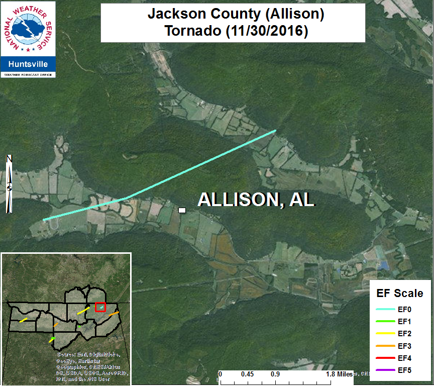
.Allison (Jackson County) Tornado...
Rating:                               EF-0
Estimated Peak Wind:       62 MPH
Path length /Statute/:         3.4 Miles
Path width /Maximum/:      30 Yards
Fatalities:                           0
Injuries:                              0

Start date:                         11/30/2016
Start time:                         211 AM CST
Start location:                    8 W Stevenson
Start Lat/Lon:                    34.87 / -85.99

End date:                          11/30/2016
End time:                           217 AM CST
End location:                     5 WNW Stevenson
End_lat/lon:                       34.89 / -85.94

Survey Summary:
A small area of tight rotation was observed within a line of strong
thunderstorms west of the Stevenson area. A NWS and UAH survey team
found EF-0 damage near the Allison area associated with this area of
rotation. Numerous large tree branches and roof damage to a large farm
shed was noted near CR-564. Additional tree damage converged near CR-53
and CR-54. Peak winds were 62 MPH.
Return to Top of Page
|
|


 Local Radar
 Weather Map