
Highlights of the 2024 Total Solar Eclipse as it crossed North and Central Texas on Monday April 8th. Read More >
Ike affects North Texas
September 2008
Ike originated as a cluster of thunderstorms off the African coast near the Cape Verde Islands on August 28th, 2008. The thunderstorms soon organized into a tropical depression 775 miles west of Cape Verde on September 1st. Six hours later, the depression reached tropical storm status. On September 3rd, tropical storm Ike became hurricane Ike, 690 miles east of the Leeward Islands. Hurricane Ike hit peak intensity as a Category 4 hurricane with estimated 145 mph winds on September 4th. Ike's rapid strengthening tied it for fifth in fastest intensification rate for Atlantic tropical cyclones, with winds increasing from 85 mph to 120 mph in 6 hours.
On September 5th, Ike took a turn to the west and southwest steering it into the Gulf of Mexico instead of north along the Eastern U.S. coast. The night of September 7th, Ike hit Cuba as a Category 4 hurricane with 130 mph winds. After passing over Cuba, Ike entered the Gulf as a Category 1 hurricane on September 9th. The warm waters of the Gulf allowed Ike to regain Category 2 hurricane status on September 10th.
Ike made landfall on the Texas coast near Galveston on September 13th at 2:00 A.M. as a Category 2 hurricane. Galveston was slammed with a 10.8 foot storm surge and 109 mph winds. Bolivar Peninsula experienced the highest storm surge, with estimates over 17 feet! Areas like Sabine Pass North and Eagle Point had storm surges around 12 feet. From there, Ike trekked north into East Texas. Winds were sustained at hurricane force until it reached southeast Anderson County, TX, where it weakened to a tropical storm. Ike continued to weaken, but remained a tropical storm for the rest of its track through Texas.

Above: Best track positions for Ike, September 1 - 14, 2008. Box in upper left shows the intensity scale for the tropical cyclone track. Click on image for full size version. (From National Hurricane Center)
Take a look at how Ike impacted North Texas by scrolling over the pictures...

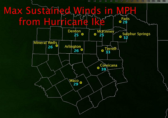
Some counties in North Texas experienced significant effects from Ike
Anderson County had estimated wind gusts over 70 mph bringing down power lines and numerous trees. These falling trees significantly damaged a few houses. In Freestone County, peak wind gusts were near 70 mph. Like in Anderson County, numerous trees and power lines were down and approximately 40 percent of Freestone County was affected by power outages. Leon County experienced 60 to 70 mph wind gusts and approximately 75 percent of the county was without power late in the day on September 13.
~*~*~*~*~*~*~*~*~*~*~*~*~*~*~*~*~*~*~*~*~*~*~*~*~*~*~*~*~*~*~*~*~*~*~*~*~*~
Quick Recap
September 1, 2008
o 0600 UTC (1:00 am) – Tropical Depression Nine develops
o 1200 UTC (7:00 am) – Ike born as a Tropical Storm
September 3rd
o 1800 UTC (1:00 pm) – Ike becomes a Hurricane
September 4th
o 0600 UTC (1:00 am) – Ike reaches peak intensity
September 9th
o 2030 UTC (3:30 pm) – Ike enters Gulf of Mexico
September 13th
o 0700 UTC (2:00 am) – Ike makes landfall at north end of Galveston Island, TX
o 1800 UTC (1:00 pm) – Ike weakens to tropical storm southeast of Palestine, TX
(all times in parentheses are in Central Daylight Time)
Tropical Weather Definitions
~*~*~*~*~*~*~*~*~*~*~*~*~*~*~*~*~*~*~*~*~*~*~*~*~*~*~*~*~*~*~*~*~*~*~*~*~*~
References: National Hurricane Center - http://www.nhc.noaa.gov/pdf/TCR-AL092008_Ike_3May10.pdf
Created August 26, 2009


 Follow us on YouTube