National Weather Service United States Department of Commerce

Areas of Excessive Rainfall and Severe Thunderstorms on Wednesday

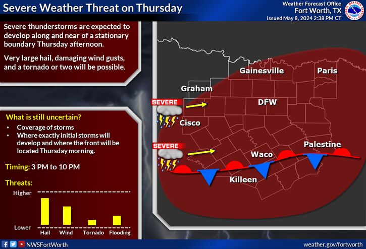
Heavy to excessive rainfall may produce additional flash flooding Wednesday across parts of the southern Plains where the greatest risk is along the Red River Valley into western Arkansas. Scattered severe thunderstorms are also possible centered on central Texas to eastern Oklahoma and western Arkansas. Large hail, damaging wind, and a few tornadoes will be possible. Read More >

A Flood Watch is in effect through 7 AM Thursday for areas north of DFW to the Red River. Most likely rain amounts between 1.5-3 inches with isolated higher amounts to 5 to 6 inches are most likely within the Watch area. Make sure to never drive through flooded roads!
Scattered severe storms are expected for develop along a dryline/front and move across North Texas tonight and again Wednesday morning. More widespread strong to severe storms will be possible during Wednesday afternoon. Large hail, damaging winds, and localized flooding will be the primary threats, thought a tornado or two will also be possible. Make sure to have multiple ways to receive warnings tonight and tomorrow!
A weak stationary front will sag south across the region from Thursday into Friday, bringing more scattered showers and storms especially to Central Texas. Some storms could be severe both days with large hail and damaging winds, and localized flooding.
Our potential for flooding will be increasing starting late tonight through Wednesday, with the highest potential for flooding across the Red River Valley and parts of the western North Texas on Wednesday. These areas have already received ample rainfall so it will not take much extra rain to cause issues. Rainfall totals in the north will generally be between 1.5-3 inches, though isolated higher amounts up to 5-6 inches will be possible within the yellow dashed shape.
Lower rain chances are expected through this weekend. Expect a slightly cooler weekend with highs in the 70s and 80s.

Text Product Selector (Selected product opens in current window)
Latest Text Products Issued (Experimental)
Safe Rooms Icon Cooperatirve Rainfall (CoCoRaHs) icon Storm Ready Icon AirNow Icon