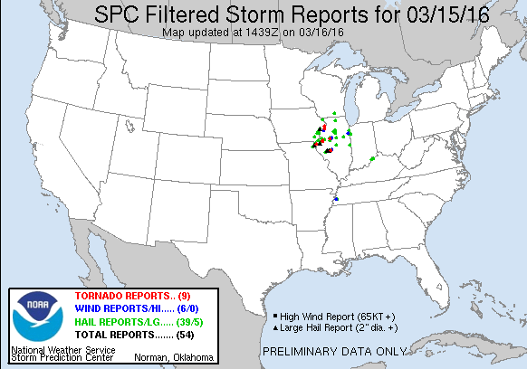
National Weather Service United States Department of Commerce

Overview


A strong area of low pressure and associated warm front tracked northeast from Missouri into northern Illinois during the evening hours of Tuesday, March 15, 2016.  Numerous severe thunderstorms developed over the region, bringing large hail and several tornadoes to the area.  The warm front lifting north was a focus area for tornadic supercells.

Additional Information:

Tornado Track Areas
NA
 

Tornadoes:

+Switch Basemap
0
Click to toggle damage path/points  
Path:    Points:
Select from the drop down list below to zoom to individual survey results

Click the icons on the map to view damage photos/info
Download KML
(Disable Pop-up Blocker)


Tornado #1 - Hampton/Rapids City, IL
Rock Island County

Date 3/15/2016
Time (Local) 725 - 735 PM CDT
EF Rating EF-2
Est. Peak Winds 130 mph
Path Length 4.8 miles
Max Width 200 yards
Injuries/Deaths 10 injuries

Summary:

An EF-2 tornado tracked north then curved to the east through upper Rock Island county.  An estimated 40 homes damaged with the most severe damage to a neighborhood in rural East Moline where 4 homes were completely destroyed.  Ten people reported minor injuries.

Track Map

Track Map EF-Scale
 

Tornado #2 - McCausland, IA
Northern Scott - Clinton County

Date 3/15/2016
Time (Local) 733 - 735 PM CDT
EF Rating EF-0
Est. Peak Winds 85 mph
Path Length 1.2 miles
Max Width 50 yards
Injuries/Deaths 0

Summary:

Damage mainly to trees.

Track Map

Track Map EF-Scale


Tornado #3 - Low Moor, IA
Clinton County

Date 3/15/2016
Time (Local) 749 - 751 PM CDT
EF Rating EF-1
Est. Peak Winds 90 mph
Path Length 1.4 miles
Max Width 75 yards
Injuries/Deaths at least 3 injuries

Summary:

An EF-1 tornado hit a mobile home park, destroying at least 5 mobile homes and damaging numerous others. At least 3 people were injuried.

Track Map

Track Map EF-Scale


Tornado #4  - Andover, IA
Clinton County

Date 3/15/2016
Time (Local) 757 - 801 PM CDT
EF Rating EF-1
Est. Peak Winds 95 mph
Path Length 3.4 miles
Max Width 300 yards
Injuries/Deaths 0

Summary:

An EF-1 tornado tracked northeast across Clinton County, damaging mainly farm outbuildings and trees.

Track Map

Track Map EF-Scale


Tornado - #5 Good Hope/StAugustine, IL
McDonough, Warren, Fulton IL

Date 3/15/2016
Time (Local) 626 - 700 PM CDT
EF Rating EF-2
Est. Peak Winds 115 mph
Path Length 16.0 miles
Max Width 900 yards
Injuries/Deaths 0

Summary:

An EF-2 tornado touched down in Good Hope Illinois and traveled for 16 miles to 2.5 miles south of St. Augustine in Fulton County. Several homes were severely damaged with most of the damage occurring to farm outbuildings and trees.

Track Map

Track Map EF-Scale
 

Tornado - #6 Deer Grove,  IL
Whiteside county

Date 3/15/2016
Time (Local) 833 - 838 pm CDT
EF Rating EF-0
Est. Peak Winds 80 mph
Path Length 1.8 miles
Max Width 50 yards
Injuries/Deaths 0

Summary:

An EF-0 tornado caused damage to shingles and siding on two homes, a tree was uprooted, and part of an irrigation rig was overturned.

Track Map

Track Map EF-Scale


The Enhanced Fujita (EF) Scale classifies tornadoes into the following categories:

EF0
Weak

65-85 mph
EF1
Moderate
86-110 mph
EF2
Significant
111-135 mph
EF3
Severe
136-165 mph
EF4
Extreme
166-200 mph
EF5
Catastrophic
200+ mph
ef-scale


nws logo Media use of NWS Web News Stories is encouraged!
Please acknowledge the NWS as the source of any news information accessed from this site.
nws logo