
A Pacific storm will move across the Northwest U.S. through Thursday with low elevation rainfall, gusty winds, and mountain snows. A storm crossing the Northeast U.S. will continue gusty to high winds, scattered rain showers and limited snow showers into Thursday. Read More >
Flooding

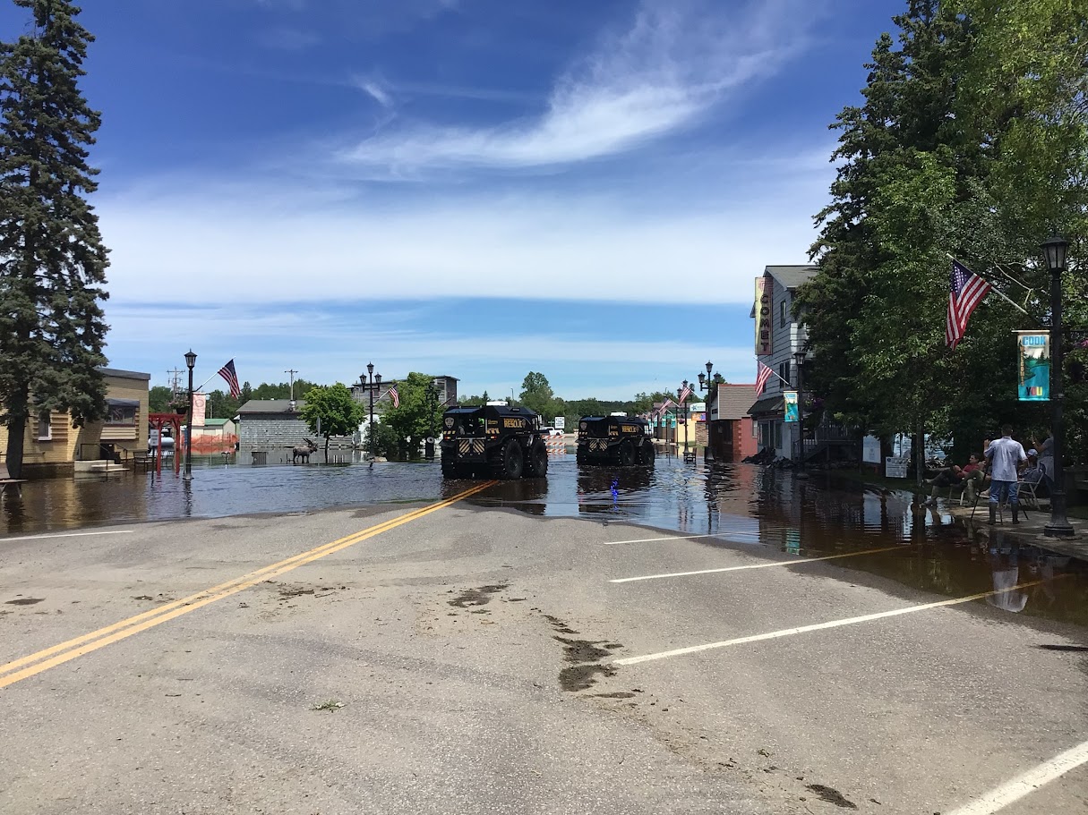
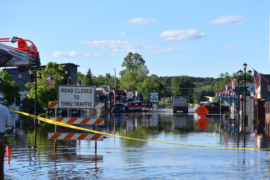
Major flooding in downtown Cook, MN from the Littlefork River, the day after flash flooding occurred across the region. Photo courtesty of St. Louis County Emergency Mgmt.
Hydrographs
 |
 |
 |
 |
 |
 |
 |
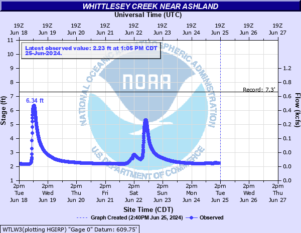 |
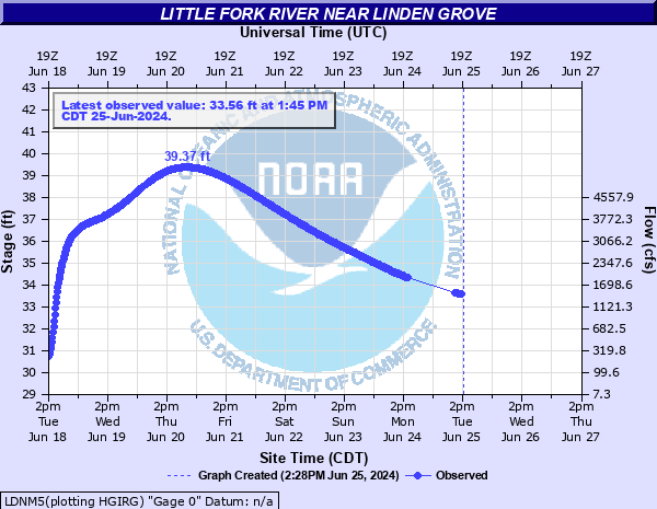
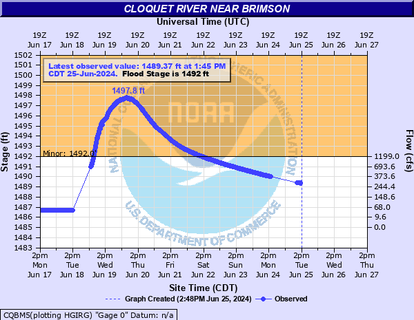
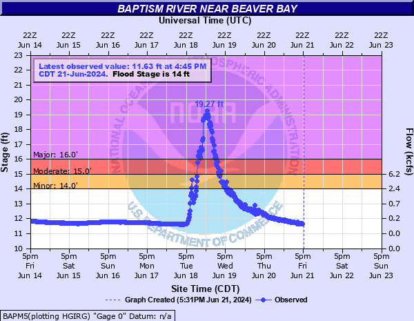
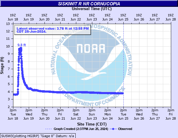
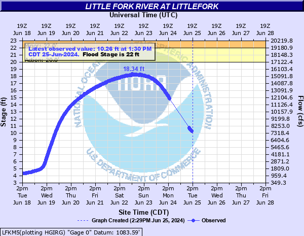
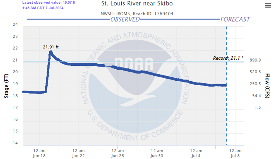
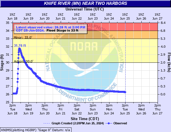
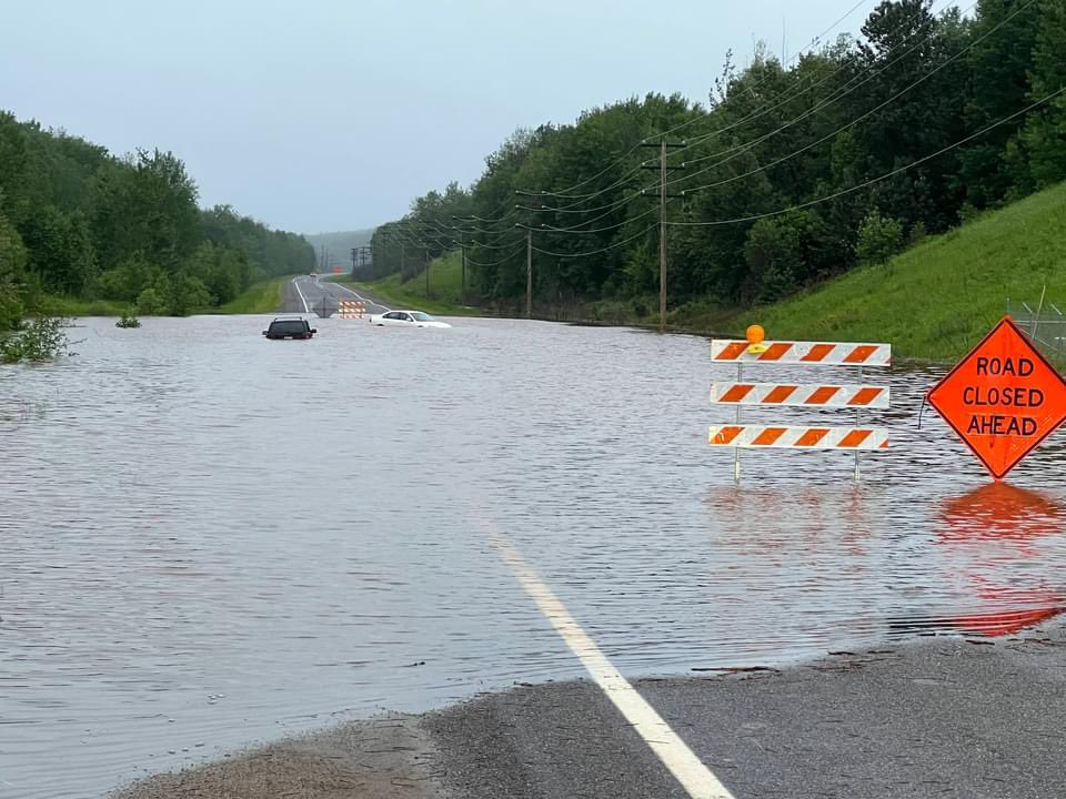
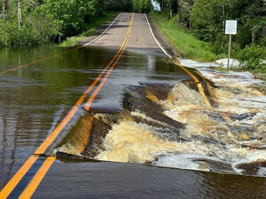
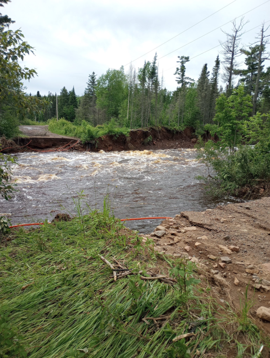
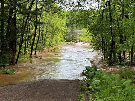
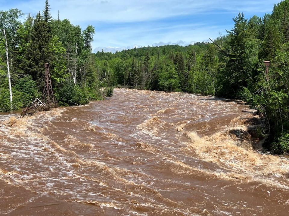
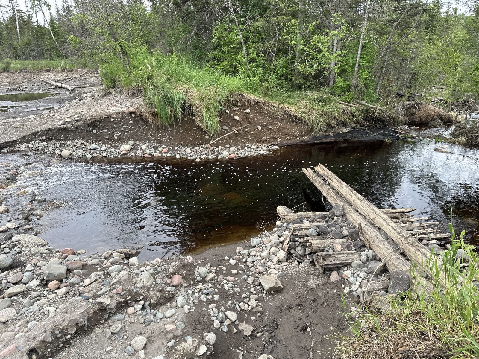
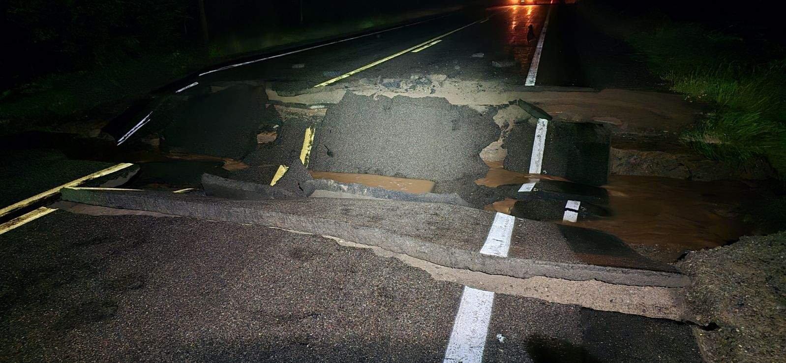
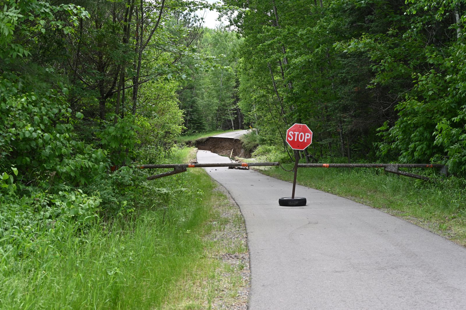
| The Littlefork River experienced historic flooding, including inundating the city of Cook with feet of water surrounding numerous buildings and structures in downtown Cook, closing dozens of roads, prompting sandbagging efforts and evacuation of parts of the city. | Up to 7.5 inches of rainfall occurred at the headwaters of the St. Louis and Cloquet Rivers in the evening of Tuesday, June 18, leading the river to rise above levels seen during the June 2012 floods. This led to major flooding of residences and road closures. | Fast reacting rivers along the North Shore responded with rapid river rises of 10 to 15 feet as 3 to 6 inches of rain fell along the MN North Shore late Tuesday evening on June 18. This would lead to bridge washouts, extensive road damage, and trail damage. | Rivers along the South Shore on the Bayfield Peninsula responded with rapid river rises as 3 to 5 inches of rainfall drained from the higher terrain of northern Bayfield County into these channeled basins. Several area waterways would briefly cover WI State Highway 13. |
Impacts (not considered to be a comprehensive list)
Photos & Video
Flooding
 |
 |
 |
 |
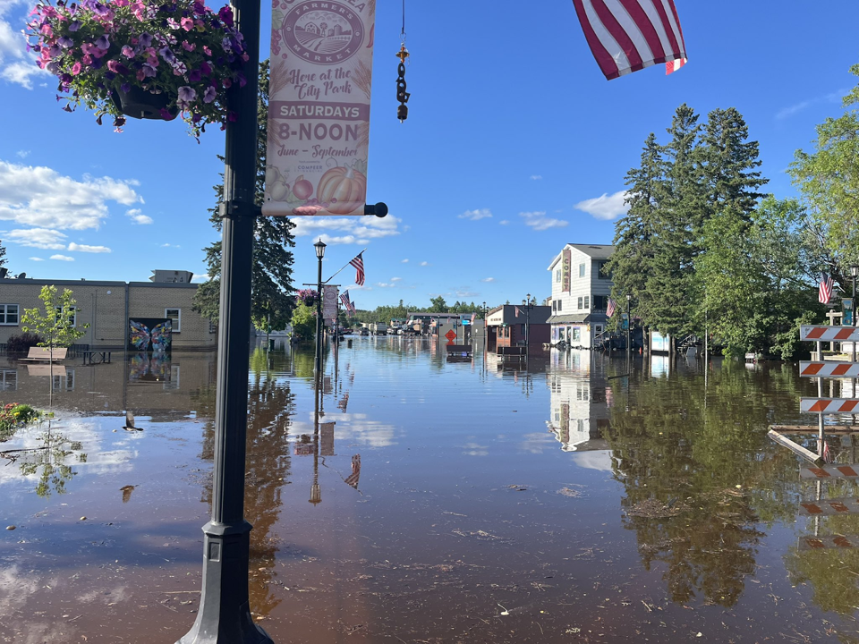
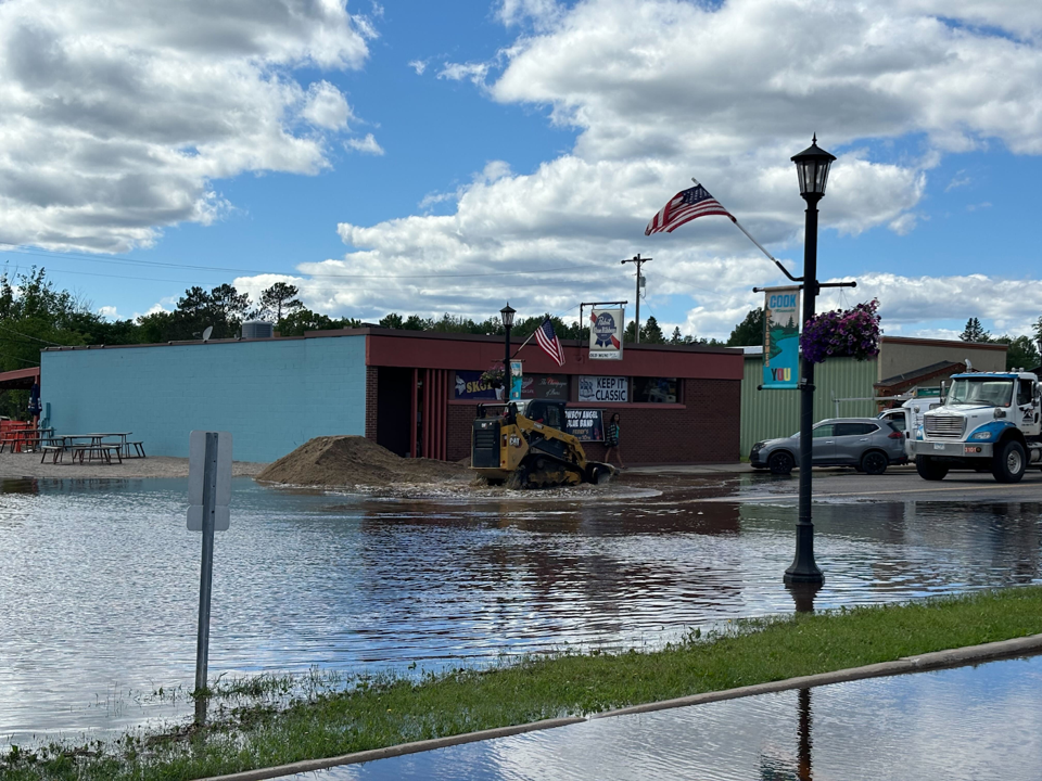
| St Louis Rescue Squad volunteers navigating the flooded town of Cook, MN on Friday, June 21, 2024 post-heavy rainfall with flooding inundating much of the town structures and roadways. (National Weather Service) |
City of Cook with flood waters on Wednesday, June 19 in the city limits resulting in closed roads and inundated structures. (National Weather Service) |
City of Cook with flood waters on Wednesday, June 19 in the city limits resulting in closed roads and inundated structures. (National Weather Service) |
City of Cook with flood waters on Wednesday, June 19 in the city limits resulting in closed roads and inundated structures. (National Weather Service) |
 |
 |
 |
 |
| City of Cook with flood waters on Wednesday, June 19 in the city limits resulting in closed roads and inundated structures. (National Weather Service) |
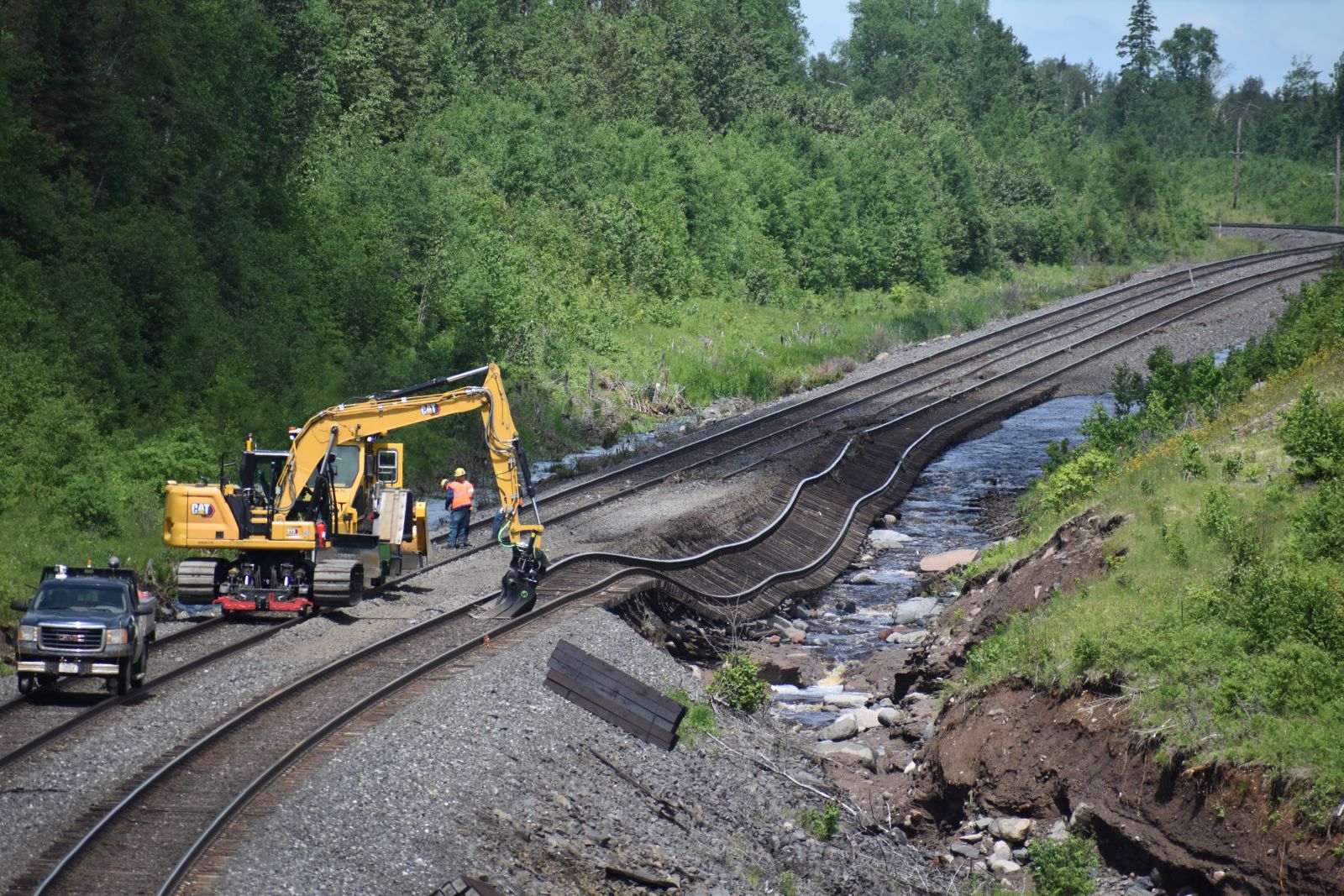
Railroad tracks washed out, shown on Wednesday June 19, after heavy rainfall the previous day resulted in flash flooding. (NWS Duluth) |
Two vehicles were trapped in the flood waters on Highway 169 near Hibbing, MN during the mid-morning hours of Wednesday, June 19. (Courtesy of St. Louis County via Twitter) |
Flooding in the city of Hibbing, MN (Courtesy of Joe Ellen) |
 |
 |
 |
 |
| Weiss Creek flooded over and washed out parts of MN State Highway 1 near Isabella as of Wednesday, June 19. (National Weather Service) |
A forest road bridge was washed out on the Baptism River near Finland from the flash flooding. (Courtesy of Dan Wolfe, KBJR via Twitter) |
A bridge along the Superior Hiking Trail covered in flood waters from the Beaver River on the morning of Wednesday June 19. (National Weather Service) |
The Swinging Bridge above High Falls in Tettegouche State Park was inundated with flood waters from the Baptism River on Wednesday, June 19. (Courtesy of @akpix via Twitter) |
 |
 |
 |
 |
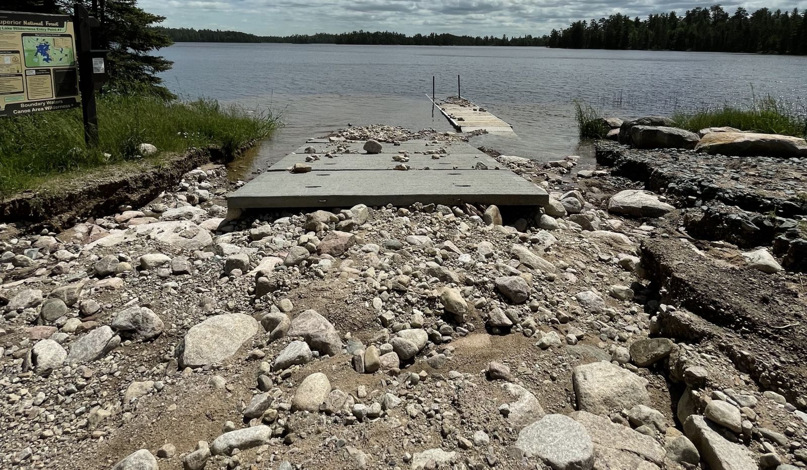
| Washed out boat ramp on Big Lake after flash flooding occurred in the Superior National Forest in the evening and overnight of Tuesday, June 18, 2024. (Courtesy of Superior National Forest, via Flickr) |
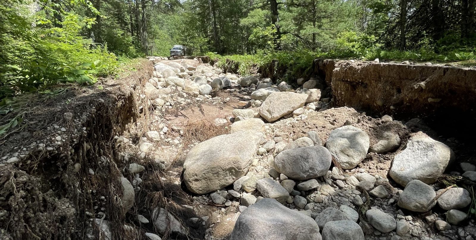
A washed out Forest Service road leading to Big Lake after flash flooding occurred in the Superior National Forest in the evening and overnight of Tuesday, June 18, 2024. (Courtesy of Superior National Forest, via Flickr) |
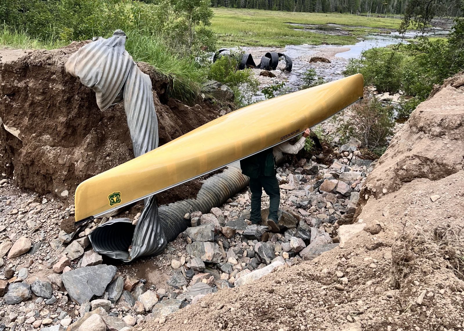
A person portaging around damage left after flash flooding occurred in the Superior National Forest in the evening and overnight of Tuesday, June 18, 2024. (Courtesy of Superior National Forest, via Flickr) |
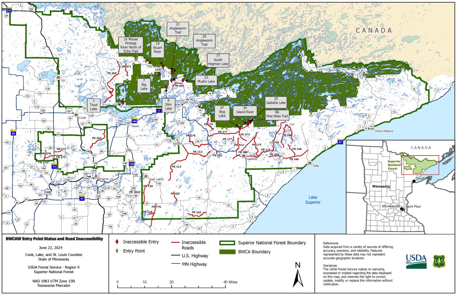
Map of BWCA entry points that were inaccessible and closed roads in the Superior National Forest after flash flooding occurred in the evening and overnight of Tuesday, June 18, 2024. (Courtesy of Superior National Forest, via Flickr) |
 |
 |
 |
 |
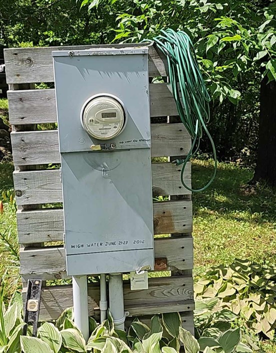
| Two lines on a breaker box show water levels from June 2024 as compared to June 2012 on Alden Lake along the Cloquet River. June 2024 levels ended up around 17" higher than 2012. (Courtesy of Marvin Forbragd) | A small earthen dam on Sullivan Lake in Lake County failed, draining the small lake. This was analyzed to have not been a significant contribution to the overall flood levels on the Cloquet River. (Courtesy of St. Louis County Emergency Mgmt) | Washout on State Highway 13 in northern Bayfield County. (Courtesy of Bayfield County Highway Department) | Washout along the Mesabi Trail near Biwabik, MN. (Courtesy of St. Louis County Emergency Management) |
 |
 |
 |
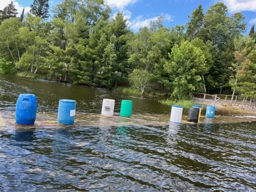 |
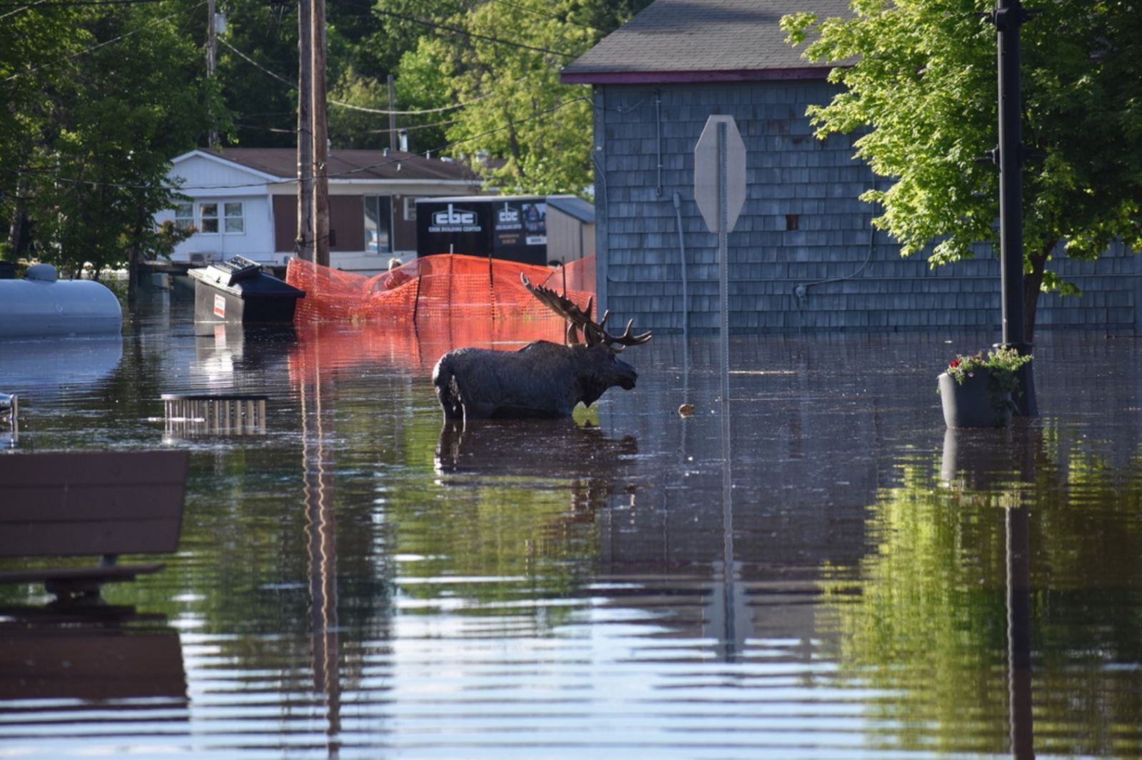
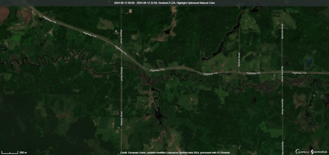
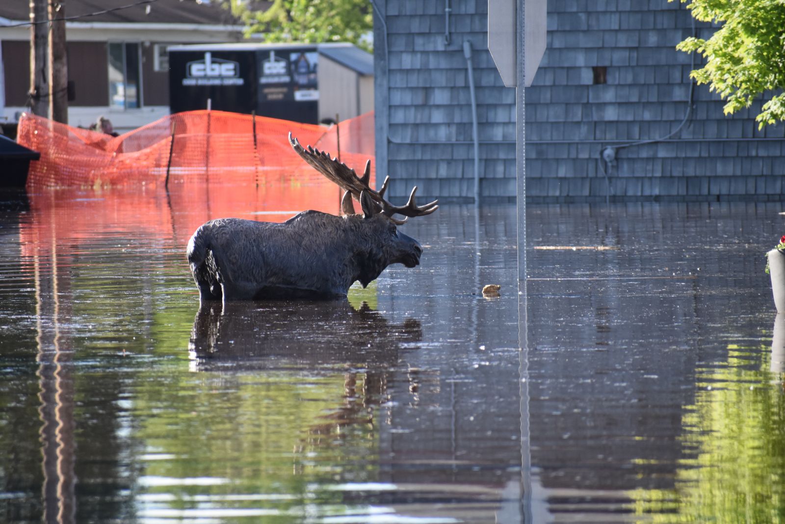
| Loop showing difference in Littlefork River inundation between June 12 and June 19 in an area upstream of Cook, MN. (Courtesy of EO Browser) | Floodwaters around a moose statue outside of the Cook Public Library in Cook, MN. (NWS Duluth) | Heavy rains over the Apostle Islands led a creek on Stockton Island to washout a trail into Quarry Bay. (Courtesy Apostle Islands National Lakeshore Park Service) | High water on Namakan/Kabetogama Lakes led to submerged docks in July, after floodwaters made it through the Rainy River Basin. (Courtesy of Voyageurs National Park) |
Severe Weather
 |
 |
.jpg) .jpg) |
 |
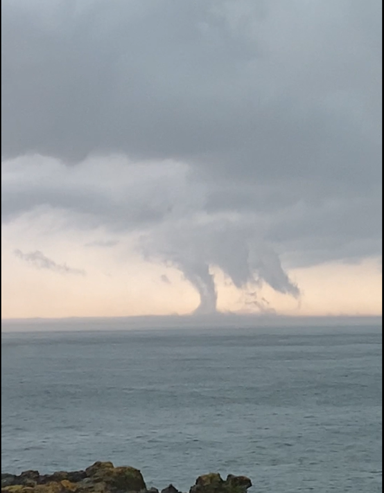
| Funnel Cloud over Moose Lake in the BWCA. (Courtesy of Tim Cigar) | A brief waterspout over Lake Superior was observed just off shore from Tofte, MN. (Courtesy of Connie Kirvida) |
Wind damaged trees near Boy River, MN. (Courtesy of Lance Christenson) |
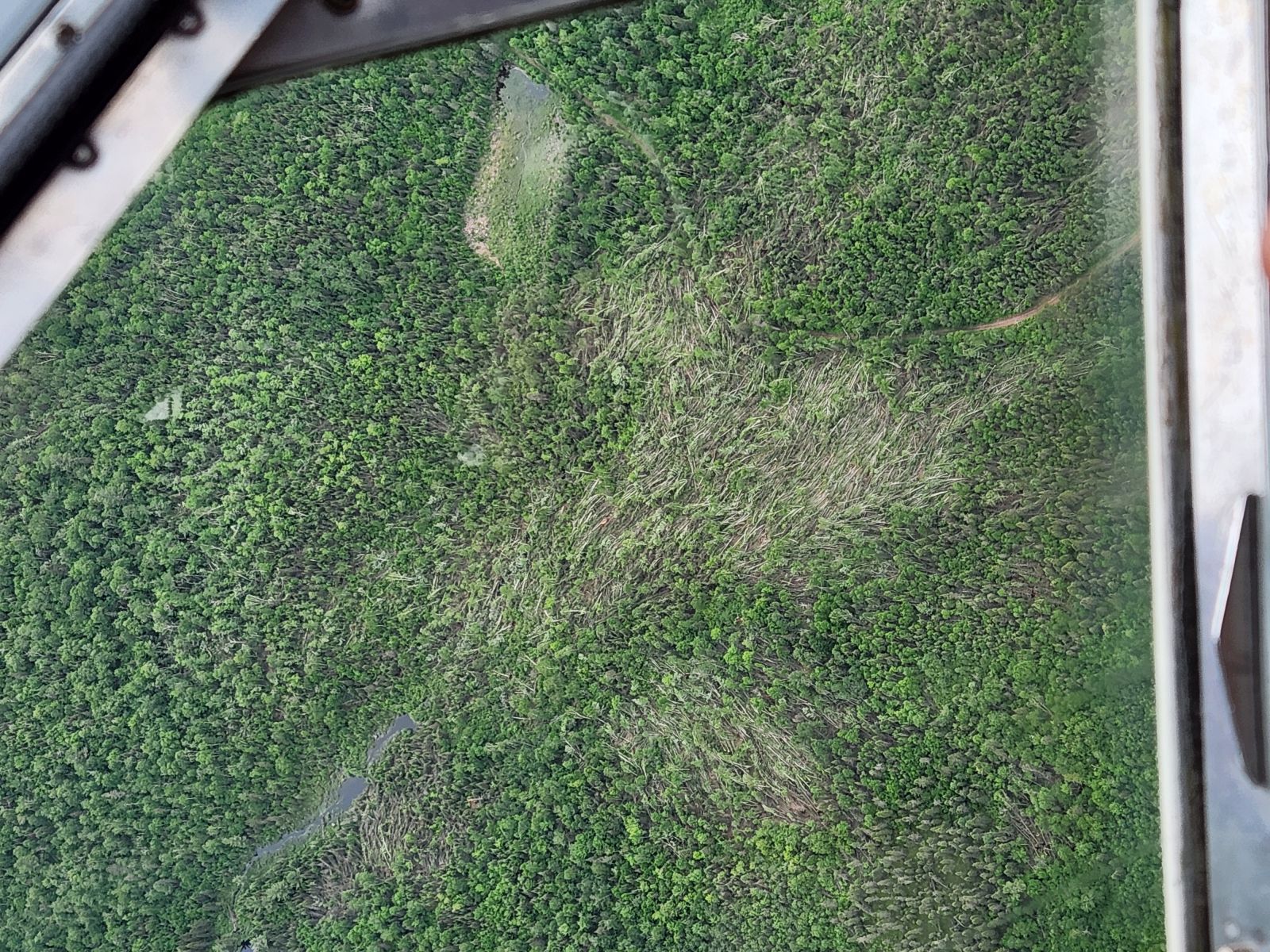
Aerial footage of pocket of wind damage in the Superior National Forest. (Courtesy of Superior National Forest, via Flickr) |
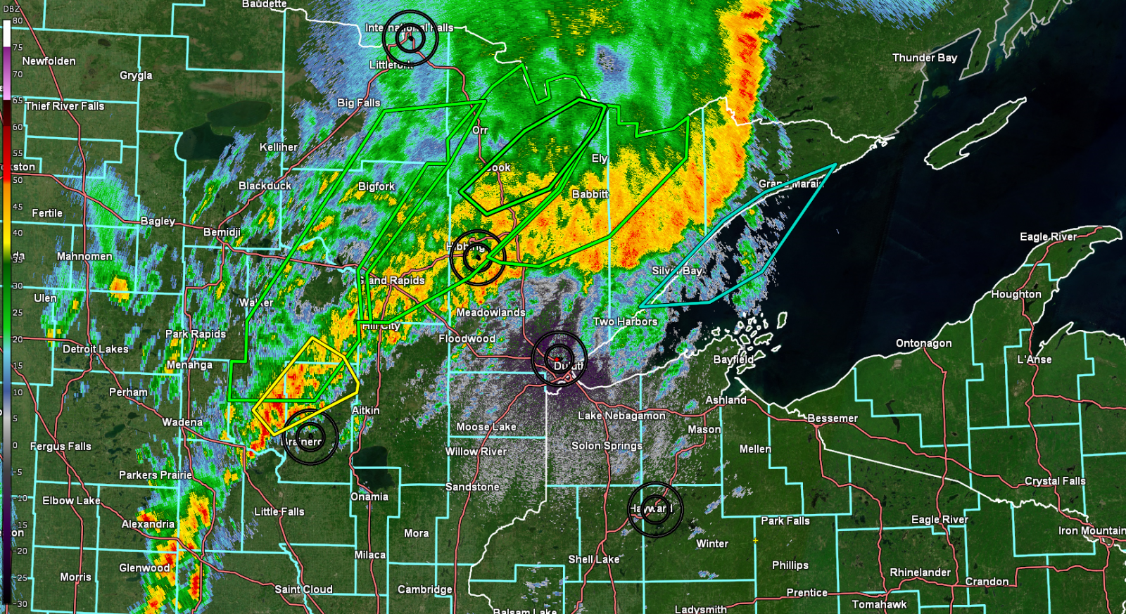
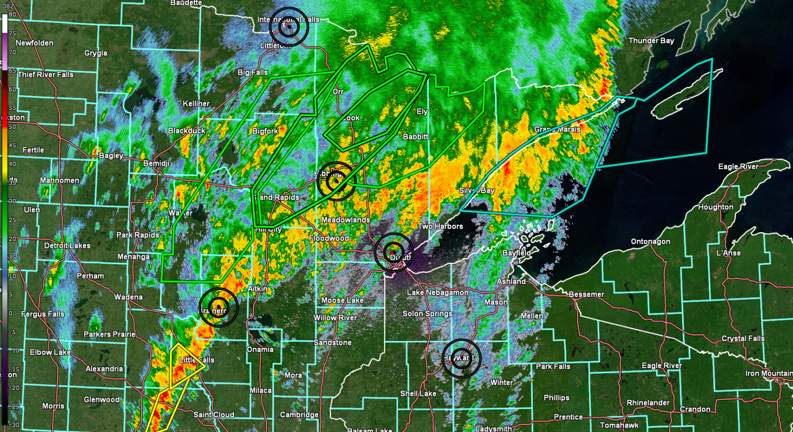
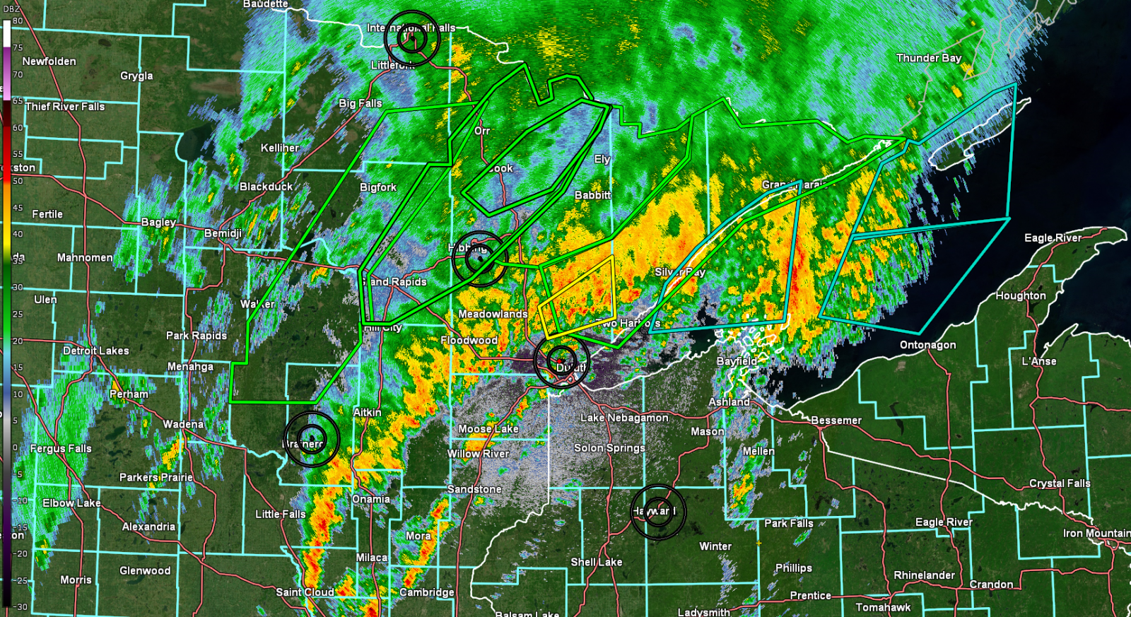
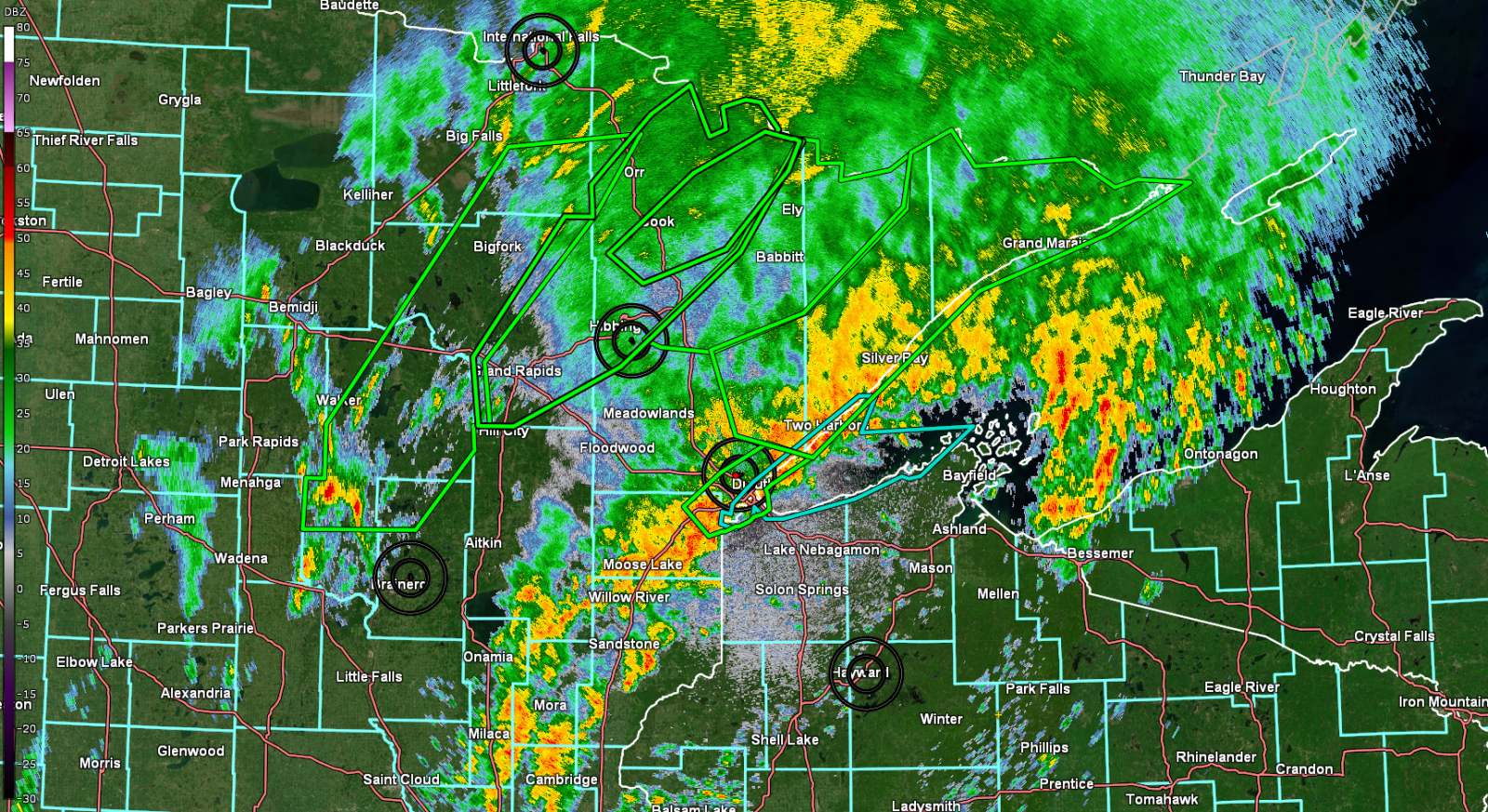
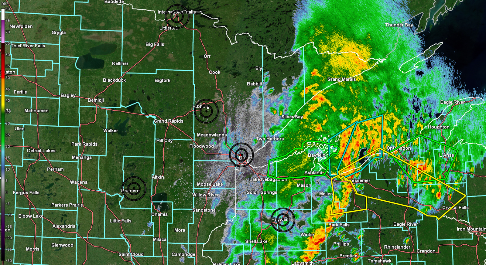
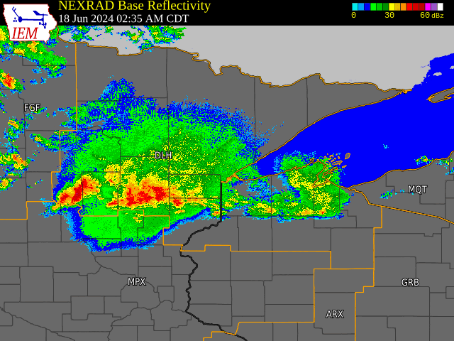
Radar and Products Issued
Radar
 |
 |
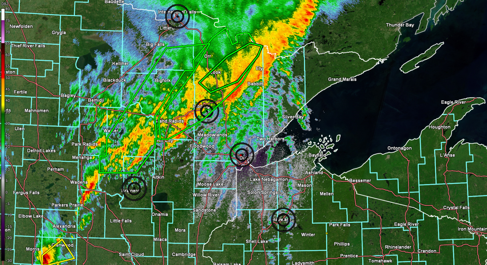 |
 |
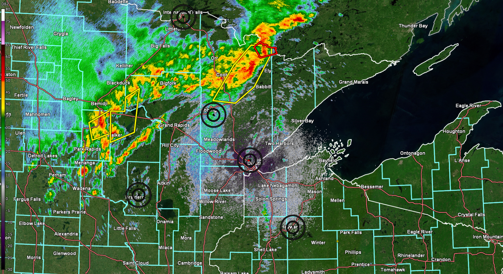
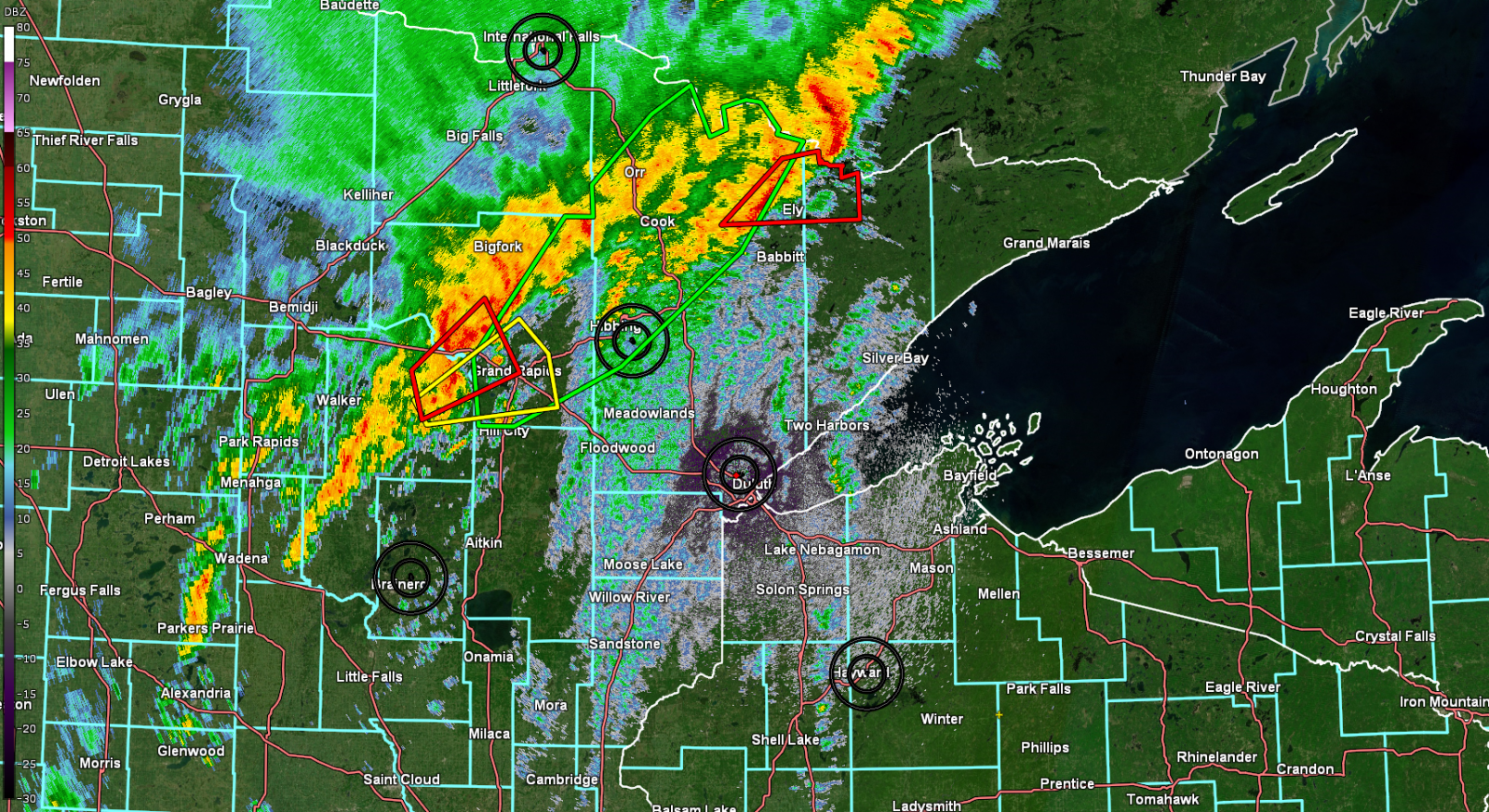
| 2:05 PM CT June 18, 2024, radar reflectivity imagery showing storms and in-effect hazards (Tornado Warnings in red, severe thunderstorms in yellow, flash flood warnings in green) from the KDLH WSR-88D radar 0.2 degree slice. | 3:04 PM CT June 18, 2024, radar reflectivity imagery showing storms and in-effect hazards (Tornado Warnings in red, severe thunderstorms in yellow, flash flood warnings in green) from the KDLH WSR-88D radar 0.2 degree slice. | 4:01 PM CT June 18, 2024, radar reflectivity imagery showing storms and in-effect hazards (Severe thunderstorms in yellow, flash flood warnings in green) from the KDLH WSR-88D radar 0.2 degree slice. | 5:05 PM CT June 18, 2024, radar reflectivity imagery showing storms and in-effect hazards (Severe thunderstorms in yellow, flash flood warnings in green, Special Marine Warning in teal) from the KDLH WSR-88D radar 0.2 degree slice. |
 |
 |
 |
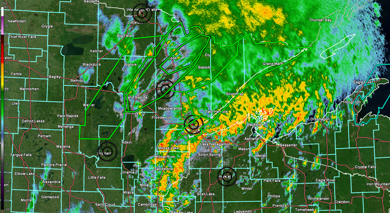 |
| 6:04 PM CT June 18, 2024, radar reflectivity imagery showing storms and in-effect hazards (Flash flood warnings in green and Special Marine Warning in teal) from the KDLH WSR-88D radar 0.2 degree slice. | 7:06 PM CT June 18, 2024, radar reflectivity imagery showing storms and in-effect hazards (Severe thunderstorms in yellow, flash flood warnings in green, Special Marine Warning in teal) from the KDLH WSR-88D radar 0.2 degree slice. | 8:02 PM CT June 18, 2024, radar reflectivity imagery showing storms and in-effect hazards (Flash flood warnings in green and Special Marine Warning in teal) from the KDLH WSR-88D radar 0.2 degree slice. | 9:03 PM CT June 18, 2024, radar reflectivity imagery showing storms and in-effect hazards (Flash flood warnings in green) from the KDLH WSR-88D radar 0.2 degree slice. |
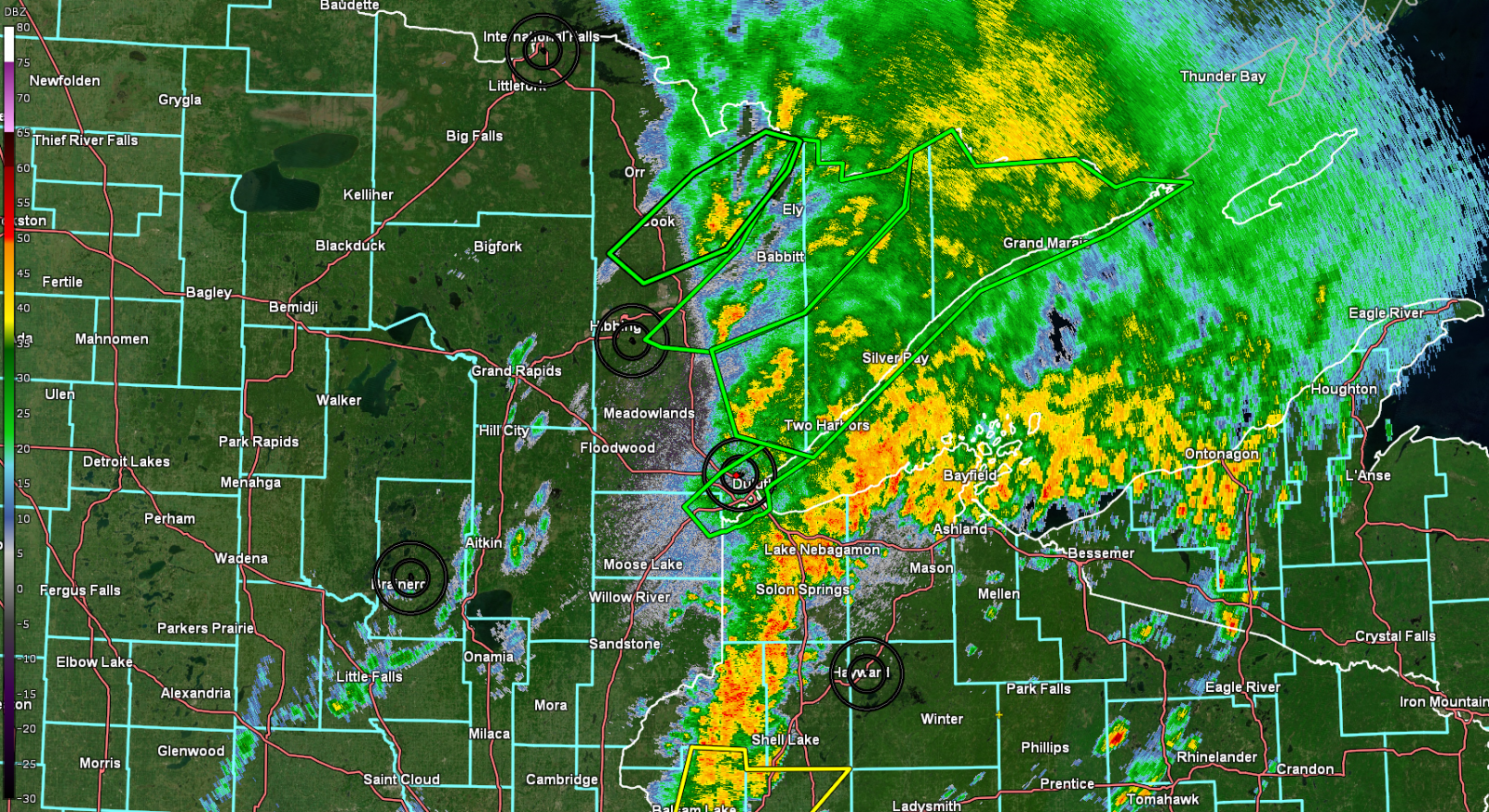 |
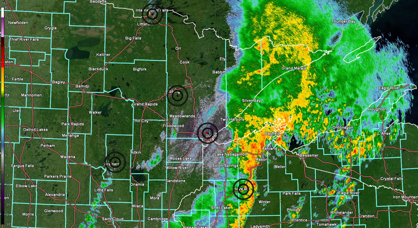 |
 |
 |
| 10:04 PM CT June 18, 2024, radar reflectivity imagery showing storms and in-effect hazards (Flash flood warnings in green) from the KDLH WSR-88D radar 0.2 degree slice. | 11:02 PM CT June 18, 2024, radar reflectivity imagery showing storms from the KDLH WSR-88D radar 0.2 degree slice. | 12:01 AM CT June 19, 2024, radar reflectivity imagery showing storms and in-effect hazards (Severe thunderstorms in yellow, flash flood warnings in green, Special Marine Warning in teal) from the KDLH WSR-88D radar 0.2 degree slice. | Loop of radar reflectivity from early Tuesday, June 18th, morning through early Wednesday, June 19th. Severe thunderstorm, flash flood, and tornado warnings plotted in real time. |
Products Issued
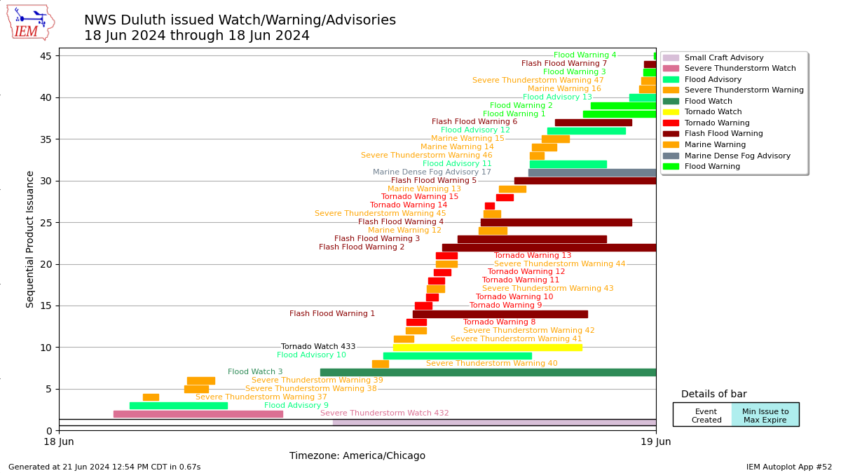 |
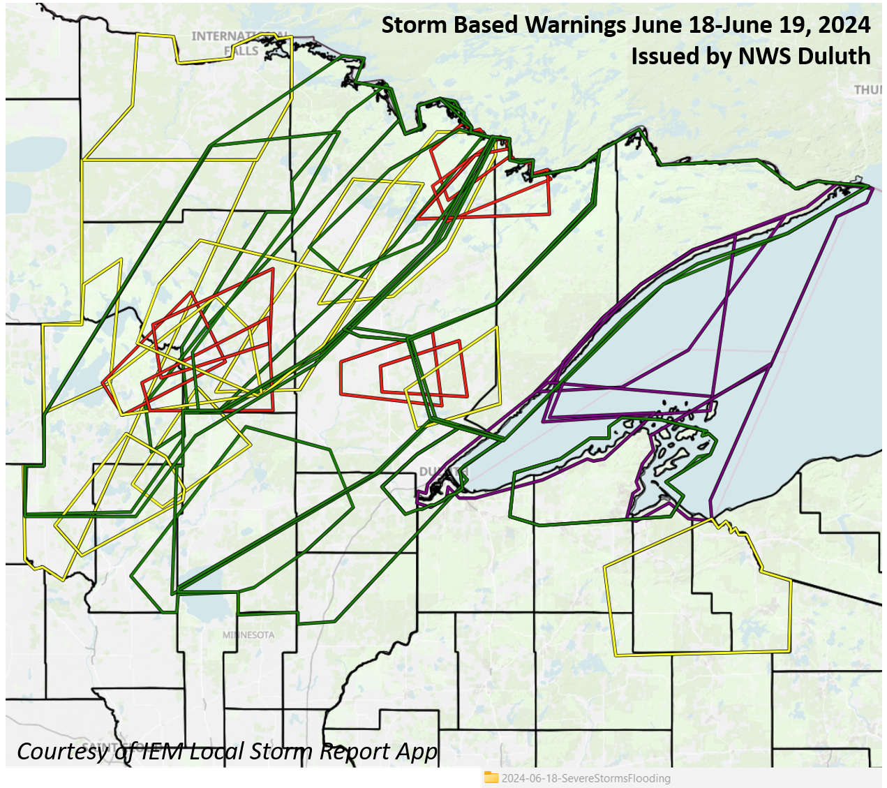 |
 |
|
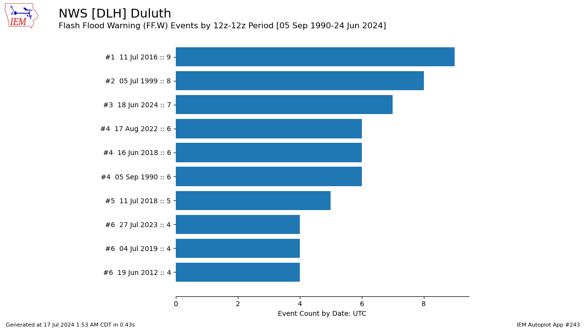
| Timeline of Watch, Warning and Advisory products issued for both severe thunderstorms (Severe Thunderstorm and Tornado Warnings and Special Weather Statements) and flooding (flash and areal flooding) on June 18, 2024. | Map of storm based warnings (Severe Thunderstorm, Flash Flood, Tornado, and Special Marine) issued by NWS Duluth June 18 - June 19, 2024 | Top 10 days for most flash flood warnings in the period 12z-12z (7am to 7am during the summer). This event ranks as the 3rd highest number of flash flood warnings issued by NWS Duluth, for the period beginning in 1990. |
Storm Reports
Flooding and Flash Flooding Reports for Tuesday, June 18 and the early morning hours of Wednesday, June 19, 2024
| Report Time (Local Time) |
County | Location | State | Event Type | Mag. | Source | Remark |
| 2024/06/18 23:00 | Bayfield | Bayfield | WI | FLASH FLOOD | Law Enforcement | Flooding and road washouts in the city of Bayfield. | |
| 2024/06/19 00:00 | Bayfield | Red Cliff | WI | FLASH FLOOD | Law Enforcement | Flooding at State Highway 13 and Blueberry Road. | |
| 2024/06/18 18:28 | Cass | 4 WSW Longville | MN | FLASH FLOOD | Public | Water over road near Tims Auto Repair. Water is halfway up car tires near edge of flooded road. | |
| 2024/06/18 14:30 | Cass | 1 S Brevik | MN | TSTM WND DMG | Emergency Mngr | Several trees snapped. One a large pine at least several feet in diameter snapped near the ground. Time estimated from radar. | |
| 2024/06/18 14:50 | Cass | 3 NE Brevik | MN | TSTM WND DMG | Trained Spotter | Trained spotter reports widespread tree damage, large white pine branches tossed, and power out. Location estimated. | |
| 2024/06/18 20:30 | Cook | 4 ENE Lutsen | MN | FLASH FLOOD | Public | Video shared via social media of flash flooding affecting Highway 61 east of Lutsen, with Highway 61 flooded in multiple locations. Time estimated. | |
| 2024/06/18 20:43 | Cook | 3 NE Tofte | MN | FLASH FLOOD | Public | A small creek flowing between two houses outside of its banks, flowing downhill. | |
| 2024/06/18 12:54 | Itasca | 1 S Nashwauk | MN | FLASH FLOOD | Public | Report from mPING. One or more of following... river or creek overflowing, cropland, yard, or basement Flooding. | |
| 2024/06/18 15:30 | Itasca | 1 S Grand Rapids | MN | FLASH FLOOD | Public | Video of water over the road. Looks like 3 to 6 inches over 2nd Ave. SE. | |
| 2024/06/18 17:25 | Itasca | 6 SSE Marcell | MN | FLASH FLOOD | Dept of Highways | Per MNDOT. flooding on road between county highway 28 and Forest Road 2373. | |
| 2024/06/18 18:53 | Itasca | Coleraine | MN | FLASH FLOOD | Public | Report from mPING. One or more of following... river or creek overflowing, cropland, yard, or basement Flooding. | |
| 2024/06/18 19:49 | Itasca | 3 SE Marcell | MN | FLASH FLOOD | Other Federal | Per MNDOT report. Flooding between Polaris Road and North Star Road, about 15 miles west of Bigfork on Hwy 38. | |
| 2024/06/18 12:21 | Itasca | 1 SW La Prairie | MN | HAIL | 0.75 | Public | Report from mPING. |
| 2024/06/18 12:36 | Itasca | 5 S Grand Rapids | MN | HAIL | 1.25 | Trained Spotter | Report via social media with photo. |
| 2024/06/18 12:47 | Itasca | 5 S Grand Rapids | MN | HAIL | 1.25 | Public | Report from mPING. |
| 2024/06/18 15:45 | Itasca | Calumet | MN | HAIL | 1 | Broadcast Media | Relayed report from viewer with photo. |
| 2024/06/18 07:05 | Itasca | 1 NE Grand Rapids | MN | TSTM WND DMG | Cocorahs | Birch tree snapped off 10 feet above the ground. This likely occurred with the first storm to go thru around 0330 this morning. | |
| 2024/06/18 18:30 | Lake | 4 E Winton | MN | FLASH FLOOD | Public | Report from mPING. One or more of following... river or creek overflowing, cropland, yard, or basement Flooding. | |
| 2024/06/18 19:09 | Lake | 5 NE Little Marais | MN | FLASH FLOOD | Public | Report from mPING: Street/road flooding; Street/road closed; Vehicles stranded. | |
| 2024/06/18 20:25 | Lake | 1 NNW Finland | MN | FLASH FLOOD | Other Federal | Per MNDOT report. Flooding between White Pine Road and Riverside Drive northeast of Finland. | |
| 2024/06/18 21:35 | Lake | 5 NE Silver Bay | MN | FLASH FLOOD | Other Federal | Per MNDOT report. Flooding and debris on roadway on MN Hwy 61 between Outer Drive in Silver Bay and Happy Acres Drive 15 miles south of Grand Marais. | |
| 2024/06/18 17:30 | LSZ141 | 3 ENE Tofte | MN | WATERSPOUT | Public | Webcam and a separate public cell phone video of what is likely a brief waterspout near Tofte on Lake Superior. Time and location estimated. | |
| 2024/06/18 14:32 | St. Louis | Chisholm | MN | FLASH FLOOD | Public | Report from mPING. One or more of following... river or creek overflowing, cropland, yard, or basement Flooding. | |
| 2024/06/18 15:00 | St. Louis | 3 E Side Lake | MN | FLASH FLOOD | Public | Video via social media of 3 to 6 inches quickly flowing down County Road 766. Entire road covered with flowing water. | |
| 2024/06/18 15:29 | St. Louis | 8 NW Tower | MN | FLASH FLOOD | Public | Report via social media with photo of water across County Road 949 at least 6 inches deep. Observer reports an additional 1.5 inches of rain in the last 40 minutes. | |
| 2024/06/18 16:00 | St. Louis | 9 WNW Tower | MN | FLASH FLOOD | Public | Report with photo. 3 to 6 inches of water across County Road 77. | |
| 2024/06/18 16:04 | St. Louis | 7 NW Tower | MN | FLASH FLOOD | Public | Delivery driver reports multiple roads under water, including Nelson and Big Rock Roads. | |
| 2024/06/18 16:11 | St. Louis | 1 SW Ely | MN | FLASH FLOOD | Trained Spotter | Pattison St and 2nd Ave E, Ely MN; street flooding incl. water flowing out of storm drain. | |
| 2024/06/18 16:18 | St. Louis | 1 NNE Cook | MN | FLASH FLOOD | Amateur Radio | Vermillion Dr and County Road 115 under water and washing out. | |
| 2024/06/18 16:20 | St. Louis | Cook | MN | FLASH FLOOD | Amateur Radio | Streets and yards in the city of Cook underwater. Low spots of Highway 24 underwater. Up to 6 to 12 inches of water across roads. | |
| 2024/06/18 16:20 | St. Louis | 3 NNE Cook | MN | FLASH FLOOD | Amateur Radio | Road under water and washing out just south of the golf course. Golf course also under water. | |
| 2024/06/18 16:20 | St. Louis | 7 W Tower | MN | FLASH FLOOD | Trained Spotter | Hwy 1 between Tower and Cook had spots with water across the road and a spot with only one lane opened. There is also a spot on Hwy 22 that has water flowing across it. This spot is deeper. Observer lost power to their vehicle after hitting it. | |
| 2024/06/18 16:50 | St. Louis | 3 WSW Cook | MN | FLASH FLOOD | Public | Report via social media with photo. Roads entirely covered with 6 inches of water. | |
| 2024/06/18 17:05 | St. Louis | Hibbing | MN | FLASH FLOOD | Public | Video from social media. Streets covered completely with at least a foot of water, maybe more in deeper spots. | |
| 2024/06/18 17:10 | St. Louis | 1 NW Chisholm | MN | FLASH FLOOD | Trained Spotter | Significant curb to curb street flooding across Chisholm. | |
| 2024/06/18 17:16 | St. Louis | 1 S Hibbing | MN | FLASH FLOOD | Public | Video from social media. Business Highway 169 covered completely with at least a foot of water, maybe more in deeper spots. Water up to the front steps of some homes. | |
| 2024/06/18 17:21 | St. Louis | 3 SSW Angora | MN | FLASH FLOOD | Dept of Highways | Per MNDOT. flooding on Minnesota Highway 53 at Hannula Road. | |
| 2024/06/18 17:25 | St. Louis | 1 SW Ely | MN | FLASH FLOOD | Public | Photo from social media. East Pattison Road completely under a foot of water. | |
| 2024/06/18 17:40 | St. Louis | 7 SW Shermans Corner | MN | FLASH FLOOD | Public | A few inches of water over residential gravel road. | |
| 2024/06/18 17:42 | St. Louis | 5 E Angora | MN | FLASH FLOOD | Dept of Highways | Per MNDOT. flooding on Minnesota Highway 1 in both directions between Brown Road and County Road 361. | |
| 2024/06/18 17:52 | St. Louis | 2 ENE Angora | MN | FLASH FLOOD | Dept of Highways | Per MNDOT. flooding on Minnesota Highway 1 in both directions. between Sassas Road and Brown Road. | |
| 2024/06/18 17:56 | St. Louis | 7 E Side Lake | MN | FLASH FLOOD | Dept of Highways | Per MNDOT. flooding on Minnesota Highway 73 between Forest Road 272 and Osborn Road. | |
| 2024/06/18 18:00 | St. Louis | 8 WNW Tower | MN | FLASH FLOOD | Public | Report via social media with video. Breezy Point road complete washout. At least 8 feet across. | |
| 2024/06/18 18:27 | St. Louis | 2 SSE Hibbing | MN | FLASH FLOOD | Public | Roads covered in water from church to car wash. | |
| 2024/06/18 18:28 | St. Louis | 1 ESE Gilbert | MN | FLASH FLOOD | Dept of Highways | Highway 135 flooded between MN 37 and Heritage Trail. | |
| 2024/06/18 19:04 | St. Louis | 2 E Mountain Iron | MN | FLASH FLOOD | Public | Water in yard covering driveway and backed up to buildings for a couple houses in this area. | |
| 2024/06/18 19:06 | St. Louis | 2 SSE Hibbing | MN | FLASH FLOOD | Public | Water in resident driveway. Reporter mentioned that water came up to the top of their rain boots. | |
| 2024/06/18 19:18 | St. Louis | 6 SW Tower | MN | FLASH FLOOD | Public | Per MNDOT report. Flooding between Karjala Road and Koski Road. | |
| 2024/06/18 19:24 | St. Louis | Floodwood | MN | FLASH FLOOD | Public | Report from mPING. One or more of following... street or road flooding, street or road closed, vehicles stranded. | |
| 2024/06/18 19:34 | St. Louis | Celina | MN | FLASH FLOOD | Public | Per MNDOT report. Flooding between MN Hwy 65 and US Hwy 53 on MN Hwy 1. | |
| 2024/06/18 19:48 | St. Louis | 1 ESE Gilbert | MN | FLASH FLOOD | Dept of Highways | Flooding on Minnesota Highway 135 just east of Gilbert. | |
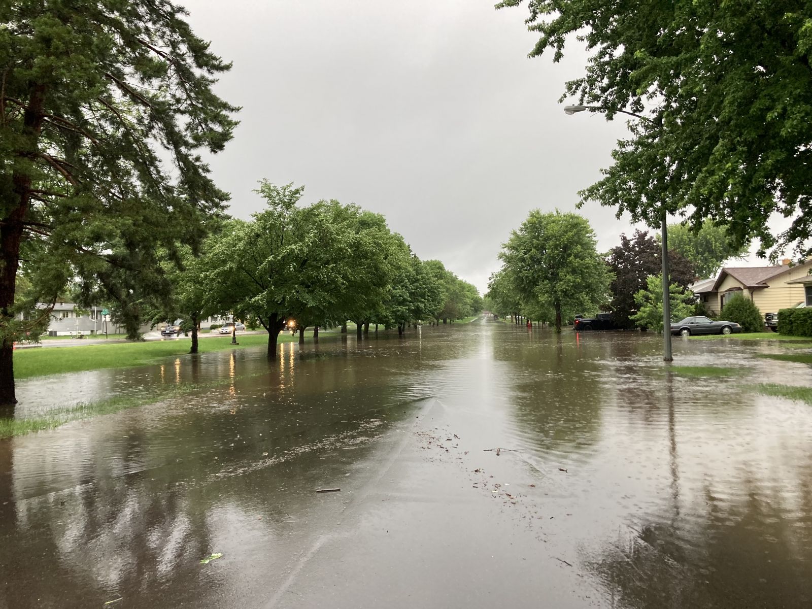
| 2024/06/18 20:15 | St. Louis | 2 NE Duluth | MN | FLASH FLOOD | Public | Public video of flash flood waters flooding a sidewalk close to a home/apartment building and nearby road. Water appears at least 6 inches deep and is flowing fast. Time estimated. | |
| 2024/06/18 20:30 | St. Louis | 1 ENE Duluth | MN | FLASH FLOOD | Public | Social media video shared by news source of flash flooding in the I-35 tunnel. Time estimated. | |
| 2024/06/18 20:45 | St. Louis | 2 NE Duluth | MN | FLASH FLOOD | Dept of Highways | Webcam imagery of flash flooding causing flooding in the I-35 tunnel near 10th Ave E. Time estimated. | |
| 2024/06/18 21:00 | St. Louis | 2 NE Duluth | MN | FLASH FLOOD | Public | News video showing flood waters flowing across a road and yard near Portland Manor on corner of E. 4th street and 9th Ave E. Time estimated. | |
| 2024/06/18 21:02 | St. Louis | 3 S Rice Lake | MN | FLASH FLOOD | Public | Report from mPING. One or more of following... river or creek overflowing, cropland, yard, or basement Flooding. | |
| 2024/06/18 15:25 | St. Louis | 15 N Robinson | MN | FUNNEL CLOUD | Public | Report via social media with photo. Funnel cloud seen looking NW from Moose Lake in the BWCA. Persisted for roughly 2-3 minutes. Time approximate from reporter. | |
| 2024/06/18 13:14 | St. Louis | Chisholm | MN | HAIL | 0.5 | Public | Report from mPING. |
| 2024/06/18 13:34 | St. Louis | 8 NW Tower | MN | HAIL | 0.75 | Public | Report from mPING: Dime (0.75 in.). |
Rain Reports
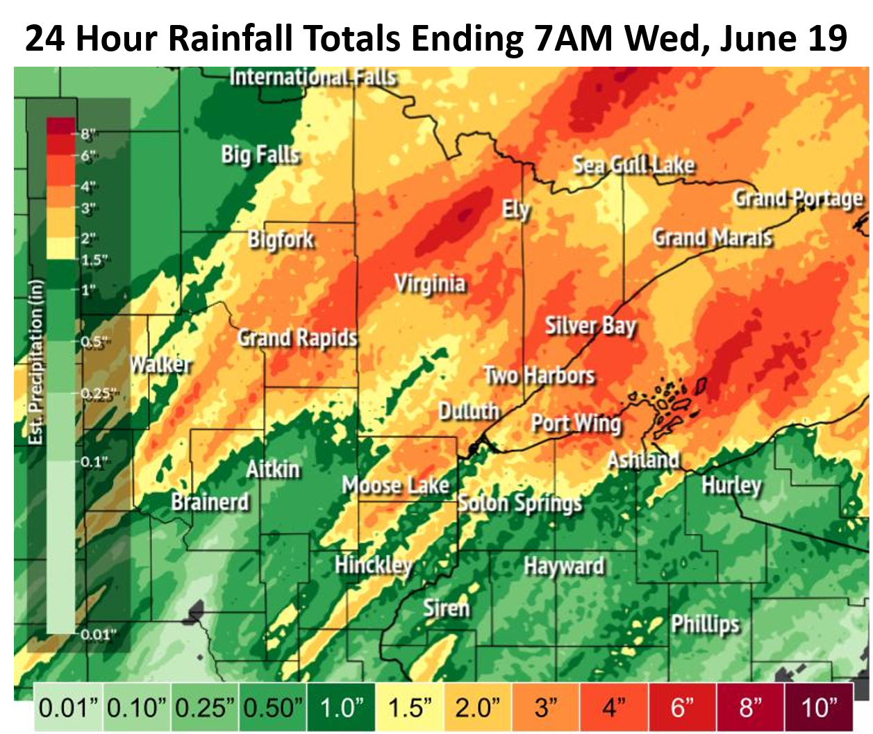
The highest bullseyes of heavy rain saw up to 5-8 inches of rain, with a widespread 3"+ across the Northland. Much of this rain fell in a 6-8 hour period. The heaviest rain was analyzed as 500-1000 year rainfalls, or more. This rain fell on top of already saturated soils from a wet spring and June. Rainfall rates of 2.5"/hour were observed, and rates as high as 3-4"/hour were estimated by radar.
 |
 |
 |
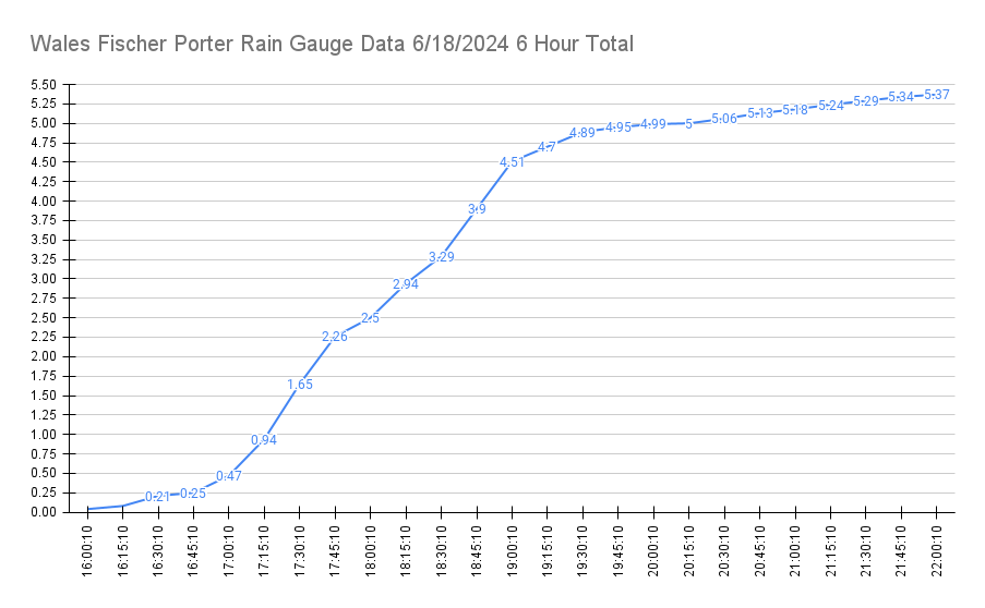 |
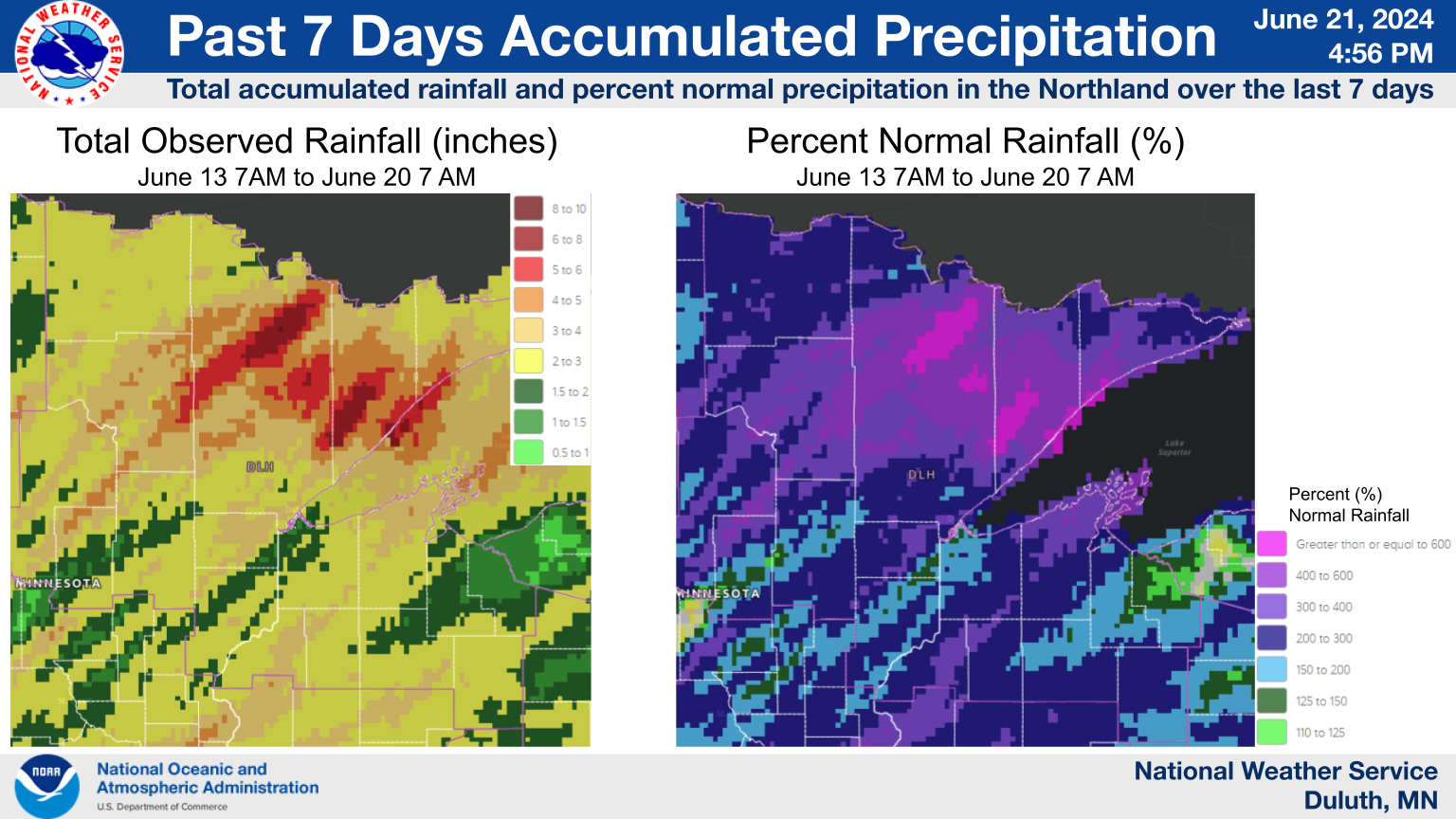
| 6 Hour Recurrence Intervals. 500 to 1000 year rainfalls have a 0.1-0.2% chance of happening in a given year. | 7 Day Rainfall Accumulations and percent of normal | 24 Hour Rainfall totals | 6 hour total rainfall data from a weighing rain gauge near Wales, MN shows how fast rain accumulated in the afternoon/evening of the 18th. |
24 Hour Rainfall Reports for Tuesday, June 18 and the early morning
hours of Wednesday, June 19, 2024
Location                     Amount    Time/Date       Provider

...Minnesota...

...Aitkin County...
Hill City 0.9 N              2.27 in   0700 AM 06/19   COCORAHS

...Carlton County...
Carlton 6.0 SW               2.84 in   0700 AM 06/19   COCORAHS
Cloquet 5.7 SW               2.66 in   0700 AM 06/19   COCORAHS
Cloquet 2.1 ESE              2.64 in   0700 AM 06/19   COCORAHS
Wrenshall                    2.46 in   0800 AM 06/19   UCOOP
Cloquet 3.4 ENE              2.30 in   0700 AM 06/19   COCORAHS
Moose Lake 0.6 SW            2.05 in   0700 AM 06/19   COCORAHS

...Cass County...
Pine River 8.4 N             3.00 in   0700 AM 06/19   COCORAHS
Outing 2.9 ENE               2.92 in   0700 AM 06/19   COCORAHS
Longville 4.5 SW             2.56 in   0800 AM 06/19   COCORAHS
Cass Lake                    2.40 in   0800 AM 06/19   COOP
Remer 11.5 WSW               2.28 in   0800 AM 06/19   COCORAHS
Remer 8.8 SW                 2.07 in   0653 AM 06/19   COCORAHS
Federal Dam 3.8 NNW          2.05 in   0600 AM 06/19   COCORAHS
Federal Dam 0.3 S            2.05 in   0700 AM 06/19   COCORAHS
Walker Community Center      2.01 in   0700 AM 06/19   COOP

...Cook County...
Tofte 4.9 NE                 5.44 in   0700 AM 06/19   COCORAHS
Tofte 2.1 NE                 5.30 in   0700 AM 06/19   COCORAHS
Lutsen 11.8 N                4.05 in   0700 AM 06/19   COCORAHS
Grand Marais 4.4 W           3.21 in   0630 AM 06/19   COCORAHS
Grand Marais 4.4 WSW         2.96 in   0700 AM 06/19   COCORAHS
Grand Marais 0.3 SW          2.90 in   0548 AM 06/19   COCORAHS
Seagull Lake RAWS            2.77 in   0904 AM 06/19   RAWS
Grand Marais 3.8 NNE         2.75 in   0700 AM 06/19   COCORAHS
Grand Marais 2.0 E           2.70 in   0630 AM 06/19   COCORAHS
Grand Marais 22.2 NNW        2.53 in   0800 AM 06/19   COCORAHS
3 E Sea Gull Lake            2.51 in   0700 AM 06/19   COCORAHS
3.7 NE Sea Gull Lake         2.38 in   0700 AM 06/19   COOP
Hovland 2.8 WNW              2.38 in   0700 AM 06/19   COCORAHS
Grand Marais 11.6 ENE        2.37 in   0700 AM 06/19   COCORAHS
Grand Marais 30.5 NW         2.34 in   0800 AM 06/19   COCORAHS
Grand Marais 17.6 NNE        2.10 in   0900 AM 06/19   COCORAHS
Hovland 0.1 NE               2.02 in   0700 AM 06/19   COCORAHS

...Crow Wing County...
Cross Lake Dam               4.38 in   0815 AM 06/19   COOP
Pequot Lakes 1.6 NNE         4.20 in   0843 AM 06/19   COCORAHS
Pequot Lakes 3.2 N           2.56 in   0700 AM 06/19   COCORAHS
Breezy Point 1.2 NE          2.47 in   0700 AM 06/19   COCORAHS
Breezy Point 0.9 WNW         2.34 in   0700 AM 06/19   COCORAHS
Aitkin 8.4 NW                2.31 in   0500 AM 06/19   COCORAHS
Breezy Point 1.0 SW          2.26 in   0700 AM 06/19   COCORAHS
Breezy Point 0.9 W           2.23 in   0705 AM 06/19   COCORAHS
Pequot Lakes 1.5 NW          2.20 in   0700 AM 06/19   COCORAHS

...Itasca County...
Marble 0.6 SSW               7.30 in   0640 AM 06/19   COCORAHS
Keewatin 0.2 SSE             4.54 in   0800 AM 06/19   COCORAHS
Side Lake 2.3 W              4.06 in   0700 AM 06/19   COCORAHS
Cohasset 7.4 S               3.87 in   0800 AM 06/19   COCORAHS
Bovey 3.5 S                  3.85 in   0700 AM 06/19   COCORAHS
Sugar Lake                   3.62 in   0700 AM 06/19   COCORAHS
Grand Rapids 6.2 SSW         3.61 in   0600 AM 06/19   COCORAHS
Grand Rapids 1.5 SSE         3.58 in   0700 AM 06/19   COCORAHS
Deer River 3.7 W             3.55 in   0800 AM 06/19   COCORAHS
Marcell 0.7 NNW              3.49 in   0830 AM 06/19   COCORAHS
Grand Rapids 2.3 SW          3.41 in   0800 AM 06/19   COCORAHS
Grand Rapids 0.7 SSE         3.34 in   0700 AM 06/19   COCORAHS
Coleraine 0.7 S              3.16 in   0700 AM 06/19   COCORAHS
5 S La Prairie               3.11 in   0700 AM 06/19   COCORAHS
Warba 2.2 NNW                3.10 in   0700 AM 06/19   COCORAHS
Grand Rapids 7.4 S           3.04 in   0700 AM 06/19   COCORAHS
Grand Rapids 5.2 SSE         2.82 in   0700 AM 06/19   COCORAHS
Grand Rapids 12 N            2.75 in   0630 AM 06/19   COOP
Grand Rapids 10.5 SE         2.71 in   0530 AM 06/19   COCORAHS
Bovey 13.4 N                 2.63 in   0630 AM 06/19   COCORAHS
Grand Rapids 6.1 N           2.60 in   0700 AM 06/19   COCORAHS
Swan River 3 W               2.60 in   0800 AM 06/19   UCOOP
Grand Rapids 6.1 SSE         2.54 in   0847 AM 06/19   COCORAHS
3.8 S Swan River             2.44 in   0845 AM 06/19   HADS
Cohasset 7.6 NNW             2.31 in   0700 AM 06/19   COCORAHS
Grand Rapids 5.0 N           2.20 in   0700 AM 06/19   COCORAHS

...Lake County...
Two Harbors 19.8 N           7.33 in   0700 AM 06/19   COCORAHS
Silver Bay                   6.02 in   0700 AM 06/19   UCOOP
Isabella RAWS                5.50 in   0904 AM 06/19   RAWS
Wolf Ridge                   5.32 in   0700 AM 06/19   COOP
Tettegouche State Park       5.02 in   0830 AM 06/19   UCOOP
Silver Bay 0.4 W             4.85 in   0653 AM 06/19   COCORAHS
Isabella 12.3 WNW            4.71 in   0700 AM 06/19   COCORAHS
1 NNE Winton                 4.50 in   0530 AM 06/19   Trained Spotter
Silver Bay 0.3 WSW           4.34 in   0800 AM 06/19   COCORAHS
Ely 8.1 SE                   3.70 in   0700 AM 06/19   COCORAHS
Ely 5.8 ENE                  3.02 in   0800 AM 06/19   COCORAHS
Ely 25 E                     2.94 in   0655 AM 06/19   COOP
Two Harbors 8.0 NE           2.91 in   0800 AM 06/19   COCORAHS
Winton 2.3 ENE               2.83 in   0700 AM 06/19   COCORAHS
Two Harbors 12.3 NE          2.74 in   0700 AM 06/19   COCORAHS
Two Harbors 9.7 NNE          2.63 in   0700 AM 06/19   COCORAHS
Two Harbors 10.8 NE          2.63 in   0700 AM 06/19   COCORAHS
Two Harbors 3.6 WNW          2.56 in   0700 AM 06/19   COCORAHS
Two Harbors 4.4 NW           2.42 in   0700 AM 06/19   COCORAHS
7 NNW Two Harbors            2.40 in   0700 AM 06/19   CO-OP Observer
Two Harbors 2.1 NW           2.34 in   0709 AM 06/19   COCORAHS
Two Harbors 2.0 ENE          2.30 in   0700 AM 06/19   COCORAHS

...St. Louis County...
Tower 8.3 NW                 7.60 in   0845 AM 06/19   COCORAHS
Hoyt Lakes 3.1 SSW           6.17 in   0805 AM 06/19   COCORAHS
Chisholm 3.6 NW              5.38 in   0700 AM 06/19   COCORAHS
Hoyt Lakes 3.0 SSW           5.20 in   0600 AM 06/19   COCORAHS
Brimson 2 S                  5.18 in   0700 AM 06/19   COOP
Cloquet River nr Brimson     5.18 in   0845 AM 06/19   HADS
Cook 8NE                     5.10 in   0500 AM 06/19   COOP
Biwabik 2.2 NE               4.96 in   0600 AM 06/19   COCORAHS
Chisholm 0.5 NW              4.91 in   0630 AM 06/19   COCORAHS
Chisholm 0.7 NW              4.72 in   0630 AM 06/19   COCORAHS
Superior Qd No. 2            4.65 in   0839 AM 06/19   RAWS
Chisholm 0.4 WSW             4.63 in   0700 AM 06/19   COCORAHS
Babbitt 4.4 N                4.62 in   0700 AM 06/19   COCORAHS
3.8 S Tower                  4.60 in   0730 AM 06/19   COOP
Aurora 0.6 WSW               4.40 in   0700 AM 06/19   COCORAHS
Ely 6.3 NNW                  4.37 in   0700 AM 06/19   COCORAHS
Side Lake 2.0 SW             4.36 in   0700 AM 06/19   COCORAHS
Embarrass                    4.33 in   0600 AM 06/19   COOP
Ely 6.0 NNW                  4.33 in   0700 AM 06/19   COCORAHS
Biwabik 2.9 NNE              4.29 in   0800 AM 06/19   COCORAHS
Celina 2 E                   4.22 in   0900 AM 06/19   COOP
Cook 6.0 N                   4.20 in   0800 AM 06/19   COCORAHS
Aurora 7.4 S                 4.18 in   0728 AM 06/19   COCORAHS
Embarrass 2.3 NNE            4.15 in   0700 AM 06/19   COCORAHS
Hibbing 11.6 SSW             3.78 in   0700 AM 06/19   COCORAHS
Side Lake 3.4 NW             3.74 in   0700 AM 06/19   COCORAHS
Mountain Iron 2.0 ESE        3.57 in   0700 AM 06/19   COCORAHS
Orr 3 E                      3.42 in   0600 AM 06/19   COOP
Eveleth 5.2 S                3.30 in   0700 AM 06/19   COCORAHS
Virginia 2.2 NW              3.30 in   0800 AM 06/19   COCORAHS
Ely 6.4 SSW                  3.29 in   0800 AM 06/19   COCORAHS
Buhl 0.8 SSW                 3.12 in   0700 AM 06/19   COCORAHS
Hibbing 2.1 NNE              3.11 in   0700 AM 06/19   COCORAHS
1.3 S Buyck                  3.05 in   0845 AM 06/19   HADS
4 S Winton                   3.03 in   0700 AM 06/19   COCORAHS
Ely 1.8 SSW                  2.93 in   0700 AM 06/19   COCORAHS
Cotton 5.7 ESE               2.93 in   0800 AM 06/19   COCORAHS
Duluth 2.0 NNE               2.84 in   0700 AM 06/19   COCORAHS
Duluth 1.9 NNE               2.84 in   0700 AM 06/19   COCORAHS
Duluth 2.0 NNE               2.75 in   0700 AM 06/19   COCORAHS
Aurora 16.8 S                2.75 in   0800 AM 06/19   COCORAHS
11 NE Island Lake            2.73 in   0700 AM 06/19   Trained Spotter
Duluth 1.7 NNE               2.65 in   0700 AM 06/19   COCORAHS
Duluth 3.0 NE                2.63 in   0615 AM 06/19   COCORAHS
Duluth 4.6 NE                2.62 in   0740 AM 06/19   COCORAHS
Duluth 3.3 NNE               2.60 in   0700 AM 06/19   COCORAHS
Canyon 4.6 NNE               2.58 in   0700 AM 06/19   COCORAHS
Duluth 3.6 NE                2.55 in   0700 AM 06/19   COCORAHS
Duluth 2.2 WNW               2.49 in   0700 AM 06/19   COCORAHS
Duluth 12.9 NE               2.48 in   0800 AM 06/19   COCORAHS
Duluth 13.1 NNE              2.47 in   0700 AM 06/19   COCORAHS
Duluth 17.6 NNW              2.45 in   0600 AM 06/19   COCORAHS
Ely                          2.45 in   0743 AM 06/19   Public
Cotton                       2.45 in   0800 AM 06/19   COOP
Duluth 6.0 NE                2.41 in   0550 AM 06/19   COCORAHS
Duluth 4.8 NNE               2.40 in   0635 AM 06/19   COCORAHS
Duluth 7.4 N                 2.33 in   0600 AM 06/19   COCORAHS
Duluth 6.9 NNE               2.33 in   0700 AM 06/19   COCORAHS
Duluth 4.3 NE                2.32 in   0600 AM 06/19   COCORAHS
Duluth 2.7 NE                2.32 in   0700 AM 06/19   COCORAHS
Duluth                       2.31 in   0600 AM 06/19   COCORAHS
5 NNW Knife River            2.30 in   0800 AM 06/19   COCORAHS
Knife River 1.8 N            2.29 in   0520 AM 06/19   COCORAHS
Duluth 5.6 NE                2.28 in   0700 AM 06/19   COCORAHS
Duluth 17.6 NNW              2.27 in   0700 AM 06/19   COCORAHS
Duluth 2.3 NNE               2.22 in   0800 AM 06/19   COCORAHS
Ely 2.2 S                    2.20 in   0700 AM 06/19   COCORAHS
Duluth 6.3 NE                2.20 in   0900 AM 06/19   COCORAHS
NWS Duluth                   2.12 in   0700 AM 06/19   COOP
Duluth 9.6 SW                2.09 in   0600 AM 06/19   COCORAHS
Duluth 15.4 NNW              2.08 in   0700 AM 06/19   COCORAHS
Duluth 1.0 SE                2.04 in   0900 AM 06/19   COCORAHS
Duluth 5.3 NNE               2.03 in   0800 AM 06/19   COCORAHS

...Wisconsin...

...Bayfield County...
3 SSW Cornucopia             4.25 in   0445 AM 06/19   Trained Spotter
Bayfield 2.6 WSW             3.16 in   0700 AM 06/19   COCORAHS
Bayfield 1.2 N               3.12 in   0700 AM 06/19   COCORAHS
4 SSE Herbster               3.10 in   0600 AM 06/19   Trained Spotter
Herbster 2.8 NE              2.95 in   0605 AM 06/19   COCORAHS
Bayfield Fish Hatchery       2.82 in   0800 AM 06/19   COOP
1 E Port Wing                2.78 in   0600 AM 06/19   COCORAHS
Bayfield 1.7 SW              2.47 in   0700 AM 06/19   COCORAHS
Washburn 3.7 NW              2.21 in   0720 AM 06/19   COCORAHS
Environment
Synoptic summary.
 |
 |
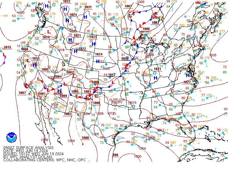 |
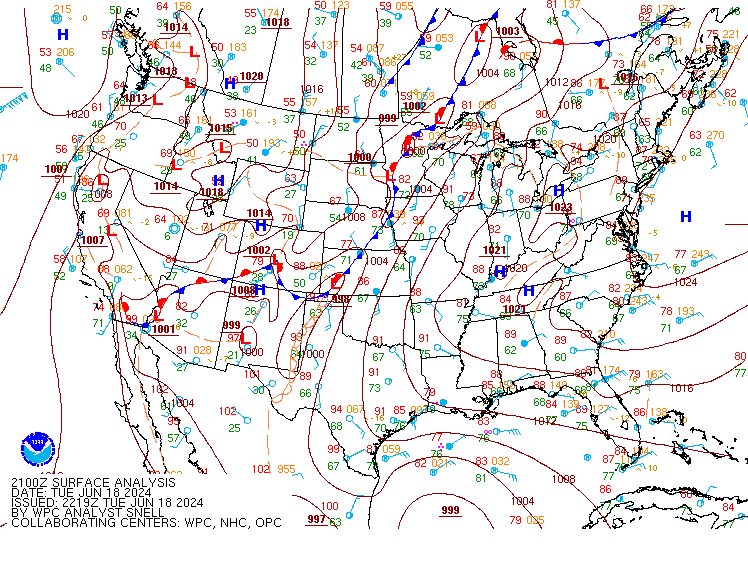
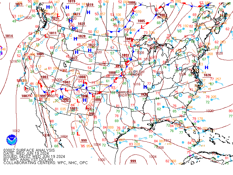
| Figure 1: Surface analysis from June 18, 2024, at 4 PM CT shows a stationary front draped from north to south over Minnesota, with much of the Northland under deep and moist southerly flow in the low-levels of the atmosphere. | Figure 2: 10 PM CT surface analysis shows that stationary front moving eastward to the MN/WI border and into the Arrowhead as a cold front drops southeastward from Manitoba. | Figure 3: 3 AM CT June 19 surface analysis shows that stationary front moving out of the Northland and into north-central Wisconsin as the cold front now in northwest Ontario drops into north-central Minnesota. |
Near-storm environment summary.
.png) |
.png) |
.png) |
| Figure 4: Deep low-level atmospheric southerly flow transported a very moist airmass into the Northland during the daylight hours of June 18, 2024. Seen here on the SPC RAP Mesoanalysis image showing 850 mb moisture transportation and precipitable water values for June 18, 2024, at 4 PM CT. | Figure 5: 7 PM SPC RAP Mesoanalysis showing that deep and very moist airmass can be seen best in eastern Minnesota with precipitable water values of 1.9 to 2.0 inches, with a drier airmass following the cold front to the northwest dropping into northwest Minnesota. | Figure 6: 10 PM SPC RAP Mesoanalysis showing the most moist layer over northwest Wisconsin by late evening hours of Tuesday, June 18, when flash flooding was reported on the Bayfield Peninsula. The much drier airmass now pushes into north-central Minnesota. |
Additional environmental data.
 |
 |
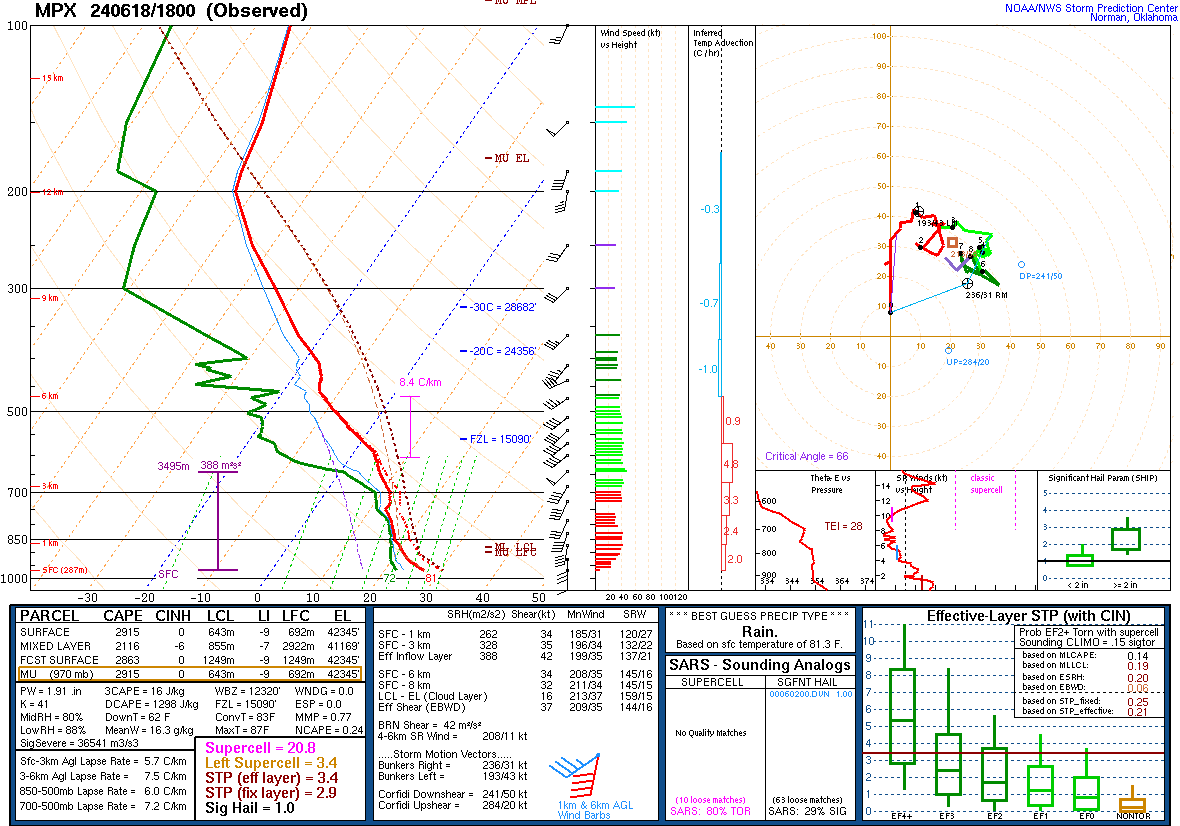 |
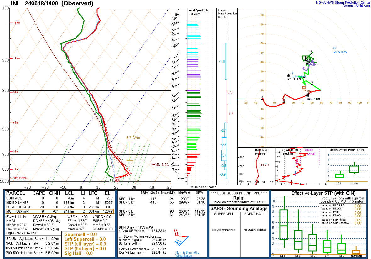
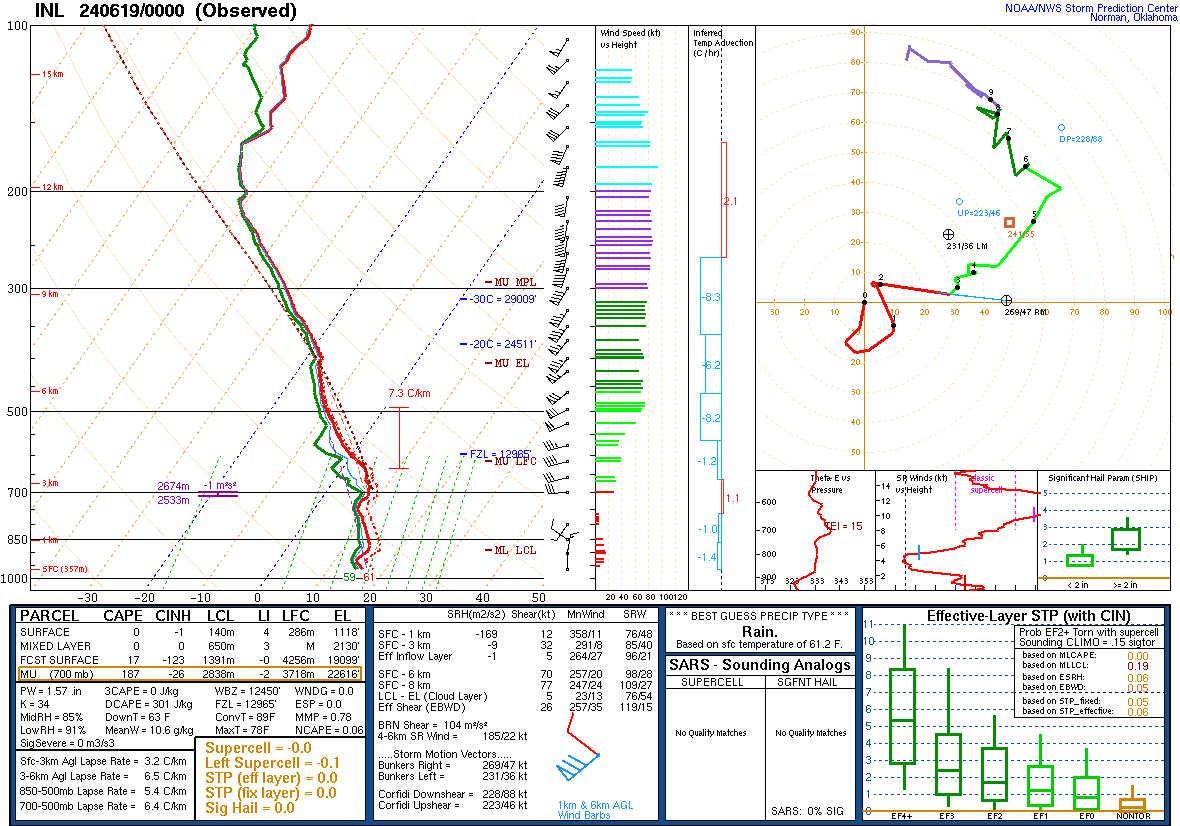
| Figure 7: Observed upper-air sounding from International Falls, Minnesota, at 9 AM CT on Tuesday, June 18, 2024, showing moisture building into the mid-levels of the atmosphere out ahead of the deep southerly flow that sets up in the later daylight hours on Tuesday. | Figure 8: 7 PM June 18 observed upper-air sounding from International Falls, MN, showing the saturated atmosphere at nearly every layer except a dry slot around 700 mb up to about 550 mb. | Figure 9: 1 PM CT June 18 observed upper-air sounding from Chanhassen, MN showing that very deep and moist (observed precipitable water value of 1.91 inches) that eventually worked into the Northland over the next few hours. Of note is also the high DCAPE (1250 J/kg) values supporting damaging wind gusts that occurred within the Arrowhead and Superior National Forest and the Mixed Layer CAPE values around 2000 J/kg and effective inflow SRH of 388 aiding in priming an environment which resulted in 5 Tornado Warnings also being issued for this day. |
 |
 |
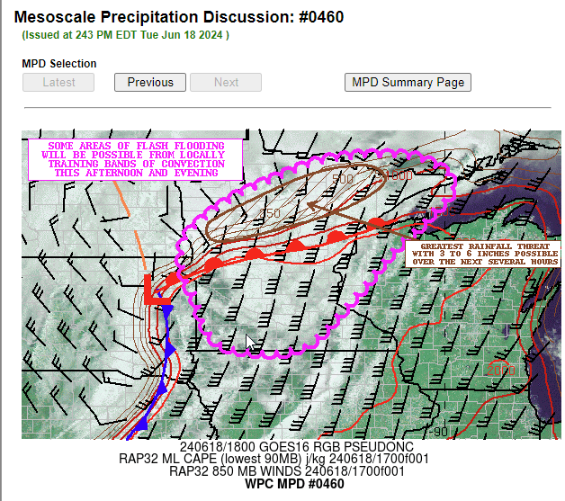
|
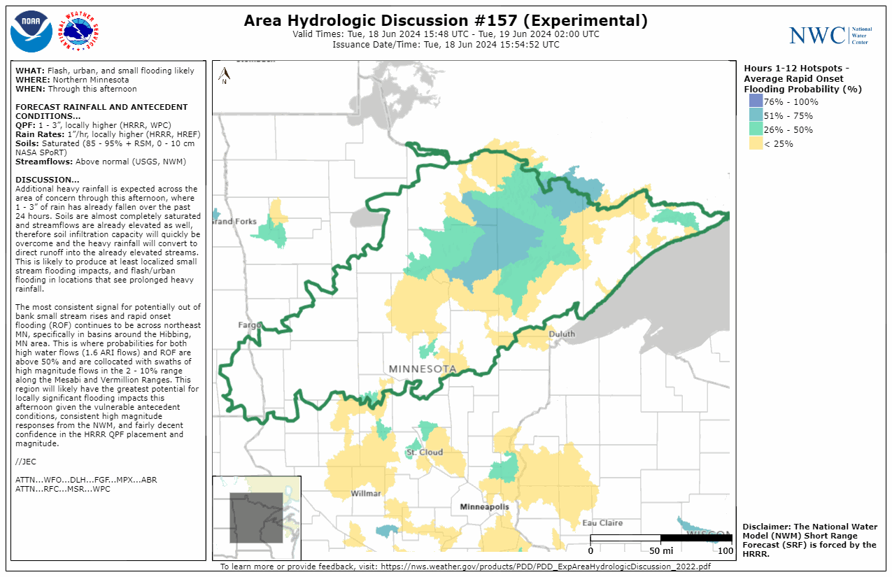
| Figure 10: The Weather Prediction Center in College Park, MD issued a Mesoscale Precipitation Discussion talking about flash flood conditions in the evening of June 18, 2024. | Figure 11: The National Water Center in issued an Area Hydrologic Discussion talking about rapid onset flooding expected from heavy rainfall in the evening of June 18, 2024. |
 |
Media use of NWS Web News Stories is encouraged! Please acknowledge the NWS as the source of any news information accessed from this site. |
|


