November 2024 was a windy month for the North Shore. The strongest wind events occurred on Veterans Day on November 11th, and then again on November 21st. Storm Warnings are issued for Lake Superior when sustained or frequent wind gusts exceed 48 knots, or 55 mph. The storm event on November 11th saw a peak gust of 55 mph at the Bay of Grand Marais, with multiple 45+ mph gusts along the North Shore into the Twin Ports. This occurred behind a strong cold front as deep low pressure moved across southern Ontario. The next storm event occurred on November 21st, as a nearly stationary low over Lake Michigan brought strong northerly winds across Lake Superior. The Bay of Grand Marais gusted to 54 mph, however, even stronger gusts were measured by a ship on Lake Superior just off shore abeam Wolf Ridge with a gust to 70 knots or 81 mph. The higher terrain of the North Shore enhanced the already strong winds, which made these high wind gusts possible near the coast and over the lake.

Low pressure over central Lake Superior and high pressure over far southern Canada kept a tight pressure gradient over the Minnesota Arrowhead on Monday November 11, 2024. This synoptic setup aided in creating very strong winds along the North Shore that moved into the nearshore waters of western Lake Superior and produced gusts to 65 knots over Lake Superior offshore from Gooseberry Falls.
Strong northerly winds occur today, strongest this morning. A Storm Warning is in effect from Grand Portage to Silver Bay with Gale Warnings for most other locations for the morning. #mnwx #wiwx pic.twitter.com/Ai7KLyB6De
— NWS Duluth (@NWSduluth) November 11, 2024
Storm Warning is in effect for Lake Superior from Grand Portage to Two Harbors. A ship observation recently had a wind gust to 65 knots near Gooseberry Falls and there was a gust to 52 knots in Grand Marais near Lake Superior.
— NWS Duluth (@NWSduluth) November 11, 2024
On January 11, low pressure over far northern Minnesota draped an occluded front through central Minnesota, where a secondary low pressure formed along a new warm front that lifted northward over northwest Wisconsin and into the Arrowhead. Lake-effect snow streamers along southeasterly flow over Lake Superior helped produce a widespread of 4 to 8 inches of new snowfall in the Arrowhead. A lake-effect "firehose" snow band sat over southern Lake County in this time period and produced snowfall totals of 15 to 17 inches, along with local amounts up to 10 inches near Grand Portage in the Tip of the Arrowhead. By January 12, as the low pressure moved eastward, there was the expectation for blizzard conditions to form along the South Shore. Strong northeast winds to 45 mph were observed, but snowfall was limited from dry air being pulled southward from Ontario. While the forecast of 8 to 16 inches of South Shore snowfall did not happen, local amounts of 8 to 12 inches were still observed in Bayfield, Ashland and Iron Counties. Sustained northeast winds at 20 to 30 mph gusted to 47 mph at Ashland Airport over a 7 hour time period to create less than 1 mile visibilities.....not quite making the 1/4 mile needed for blizzard conditions.
This next round of snow and wind will be high-impact for some and less so for others. Here's a look at total snowfall expected this afternoon through Saturday. What can you expect for your area? Take a look at the next several posts that break it down by location! #mnwx #wiwx pic.twitter.com/FBmXPDWGyU
— NWS Duluth (@NWSduluth) January 11, 2024

A band of lake effect snowfall that produced high snowfall rates setup over southern Lake County and produced 15-17 inches of snow to the high terrain ridge near Finland. The lake effect "firehose" moved northward over time and weakened in strength which limited snowfall to 4-8 inches near Grand Marais. The firehose re-strengthened in far eastern Cook County over the community of Grand Portage to produce up to 10 inches of new snow by January 12. Maps courtesy of National Operational Hydrologic Remote Sensing Center.

Snowfall along the South Shore was observed to be 4 to 6 inches by January 13th, with local pockets of 8-12 inches in Bayfield, Ashland and Iron Counties. Maps courtesy of National Operational Hydrologic Remote Sensing Center.
New snowfall ranging from 7 to 12 inches fell along the higher terrain of the North Shore above Silver Bay from Sunday afternoon December 8th into Monday December 9th. Persistent onshore winds (or winds blowing from Lake Superior towards land) interacted with the higher terrain of the North Shore (added rising motion) to generate a zone of heavy snowfall north of a slowing moving front. To the south of this front, warmer air at the surface and aloft made for a wintry mix and a mess of rain and snow with much lower snowfall amounts observed. This was a great example of an event where a few degrees of air temperatures makes all the difference in the precipitation type, and how much falls as rain or snow. This difference is exaggerated by Lake Superior when it is ice free, where immediate low level coastal areas remain warmer and receive less snow and more rain, and higher elevations with slightly cooler temperatures end up with more snow.
Snowfall totals were highly variable from Sunday afternoon into Monday morning. Some areas of the state saw only a few inches, while the greatest amounts were recorded in the upper regions of the North Shore with totals from 7 to 12 inches. pic.twitter.com/abQuFYvldg
— NWS Duluth (@NWSduluth) December 10, 2024
Low pressure located over northern Minnesota the afternoon of July 7th led to the development of scattered showers and isolated thunderstorms over northeastern Minnesota and northwestern Wisconsin. Most of this activity was very shallow in nature and did not producing hail larger than peas or much in terms of wind gusts. One shower produced a waterspout over Lake Vermilion shortly before 2:30 PM CDT. Waterspouts and funnel clouds were possible across the region due to favorable atmospheric conditions in the vicinity of the low pressure center over the region. The waterspout developed to the northwest of Echo Point and west of Ely Island on eastern Lake Vermilion. Based on radar and video of the waterspout, it moved slowly to the north-northeast before dissipating near Spider Island. It may have passed near or over Spider Island. It also passed through the vicinity of Taylor and Stonich islands. No damage reports have been received from these islands which do have structures on them. Based on photos and videos, the waterspout was about 30 yards wide and was on the water for about 2 miles. No fatalities or injuries have been reported.
A well documented waterspout was observed this afternoon on Lake Vermilion. Here is our preliminary survey along with some photos and videos. Thanks to everyone that shared their photos, videos and information with us! https://t.co/1fh3ljAq5W pic.twitter.com/BkCptUKnV2
— NWS Duluth (@NWSduluth) July 8, 2024
While the summer started out very wet in June 2024, beginning in July and lasting into mid-October 2024 a very dry and warm pattern persisted. Average temperatures on a given day in this late summer to early fall time period were 2 to 6 degrees F above normal. In this same period, precipitation deficits were leaving all areas behind normal rainfall amounts by 2 to 8 inches. As the warm temperatures lasted into the first half of October, Moderate Drought conditions were upgraded to Severe Drought. September 2024 ranked #3 for MN and #8 in WI for the driest Septembers on record.

Precipitation for the months of July - September 2024 ranged from 2 to 8 inches below normal. The least amount of precipitation compared to normal was observed along the South Shore and in the Arrowhead. The Borderlands of far north-central Minnesota were the lone place that saw slightly above normal precipitation amounts in this late summer to early fall time period. Image courtesy of Midwest Regional Climate Center.

Temperatures in northwest Wisconsin from July - September 2024 were 1 to 4 degrees F above normal, while those in northeast Minnesota were 2 to 6 degrees F above normal. Image courtesy of Midwest Regional Climate Center.
It has been a very dry fall across the Northland so far. Drought has expanded with Moderate Drought prevailing. For some, it has been more than a month since they saw their last 0.25" or more of rain. pic.twitter.com/MtfJSj6hl4
— NWS Duluth (@NWSduluth) October 6, 2024
Since Severe Drought (D2) has again been introduced into the Northland as of this week, catch up on the latest drought information at the following link: https://t.co/dKNgEVQaps #MNwx #WIwx pic.twitter.com/E7FEMkXBM3
— NWS Duluth (@NWSduluth) October 11, 2024
October was a dry and warm month. Out of 130 years of records, MN saw it's 6th warmest and 25th driest Oct. WI observed its 12th warmest and 34th driest Oct. While below normal for precip, this was better than September which ranked 3rd driest in MN and 8th driest in WI. pic.twitter.com/TlxLCpTn14
— NWS Duluth (@NWSduluth) November 9, 2024
After a historically warm and dry winter in 2023-2024, the potential for Spring wildfires was high due to a lack of snowpack for much of the winter. This lack of snowpack caused fine fuels (such as tallgrasses) in the area to remain standing up and "fluffy". While winter is the dry season in the Northland, snow still helps provide additional moisture to the area. With that minimal winter snowfall, moderate drought conditions expanded by the end of March. NWS Duluth worked closely with land management agencies and local emergency management officials in Spring 2024 to message the elevated fire potential. In April, NWS Duluth issued Red Flag Warnings to highlight critical fire weather conditions. In addition to Red Flag Warnings, NWS Duluth also issued numerous Special Weather Statements over the Spring fire season to highlight near-critical fire weather conditions.

Snowfall amounts for the winter 2023 - 2024 ending March 1, 2024 were 10-50% of normal across the entire region. The Twin Ports of MN/WI stateline and spots along the South Shore observed the least amount of snowfall compared to normal. Image courtesy of Midwest Regional Climate Center.
Near-critical fire weather conditions are expected Tuesday afternoon for much of east-central and northeast MN as well as northwest WI due to low relative humidity, warm temperatures, and gusty winds. #mnwx #wiwx pic.twitter.com/HTgSWkdR0Q
— NWS Duluth (@NWSduluth) March 11, 2024
A cold front moved through north-central Minnesota in the late afternoon hours on Thursday, September 19, 2024. Out ahead of the cold front in northeast Minnesota, discrete severe thunderstorms began to form in far northeast Minnesota along the US Hwy 53 corridor around 4 PM CT. The first Severe Thunderstorm Warning was issued at 4:15 PM for parts of far northeast St. Louis County and northwest Lake County as the severe storm moved northeastward around 30 mph. By 4:55 PM, conditions within a different severe supercell thunderstorm warranted the first Tornado Warning of the evening to be issued for central St. Louis County around the communities of Cotton and Canyon, MN. Between 5 and 5:30 PM that evening, multiple additional Severe Thunderstorm and Tornado Warnings were issued along and east of US Hwy 53 and along the I-35 corridor into east-central Minnesota. The cold front continued to move eastward through the early evening hours on the 19th, with storms beginning to enter Douglas and Burnett Counties in northwest Wisconsin towards 6 PM as funnel clouds were reported by law enforcement and trained weather spotters. Hail up to 1.5 inches in diameter was reported from the strongest thunderstorms, but in very localized reports. As the air mass began to cool and stabilized in the mid-evening hours, the threat for additional tornadoes began to wane and the strongest thunderstorms were limited to the Twin Ports and across northwest Wisconsin. As the cold front entered northwest Wisconsin by late evening, activity subsided to only showers and general thunderstorms with no additional impacts reported overnight. In total, eight Tornado Warnings, nine Severe Thunderstorms Warnings and two Special Marine Warnings were issued for this severe weather event. The Cotton/Canyon Tornado is the only confirmed tornado from this severe weather event. While funnel clouds were reported with several other storms, there is currently no evidence that any of the other storms produced a tornado that reached the ground and produced damage.
For more information about this tornado, please visit this webpage.
Preliminary Damage Survey Results from 9/19/2024 Storms: A tornado has been confirmed near Canyon/Cotton, MN. It has been rated as an EF-1 with estimated peak wind speeds around 105 mph. Please continue to send us pics/videos, whether from Cotton or elsewhere. Thanks! #mnwx pic.twitter.com/7W5NwQp8Kn
— NWS Duluth (@NWSduluth) September 20, 2024
A strong winter storm moved into the area Sunday morning, March 24th in north-central Minnesota and spread snow northeastward. The heaviest snow fell Sunday night into mid-day Monday. Localized blizzard conditions were observed over the North Shore Sunday evening through Monday afternoon. Warm air aloft brought a wintry mix of rain, freezing rain, and snow Monday and Monday night. The mixed precipitation mainly affected northwest Wisconsin and the Interstate 35 corridor. The snowfall wrapped up Tuesday afternoon and evening on March 26th.
For more information about this storm, visit this webpage.
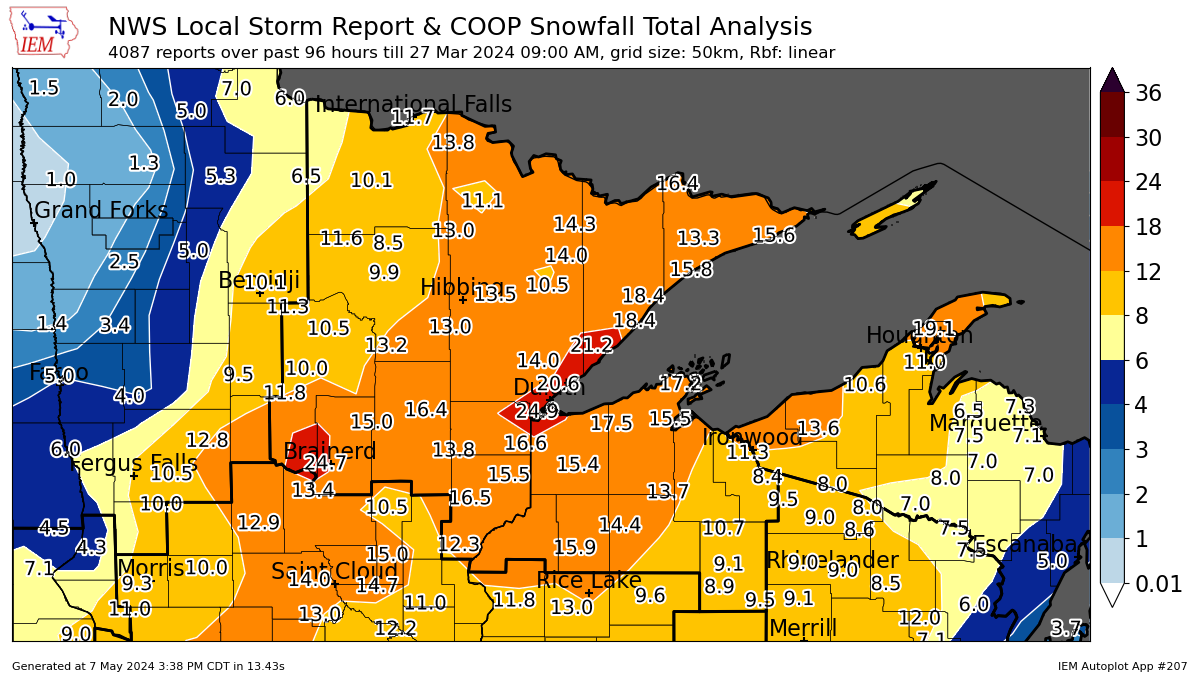
A three day snowfall was the one widespread notable winter event from the 2023 - 2024 winter. Widespread 8 - 16 inches of snowfall were observed. There were local observed snowfall amounts from Duluth to Silver Bay and east of Brainerd between 18 and 24 inches. Image courtesy of Iowa State Environmental Mesonet.
Numerous severe thunderstorms moved across north-central and northeast Minnesota on the evening of Wednesday, June 12, 2024, producing large hail to the size of baseballs, isolated thunderstorm wind damage, and several tornadoes. Two distinct supercellular storms produced five tornadoes (rated EF-0 and EF-2)
across portions of Crow Wing, Aitkin, and Carlton counties between roughly 6:15 PM and 7:30 PM. The supercell that tracked through Crow Wing and Aitkin County produced four separate tornadoes, first on/near Upper Whitefish Lake across to Clamshell Lake, or west of Crosslake, where a wide, sharp path of damage was found. This tornado dissipated, with a second tornado forming south of Wolford, west of Rabbit Lake (north of Crosby). This second tornado appeared to have a mainly continuous path of damage from near Wolford to Rabbit Lake to Cedar Lake to Prescott Lake. There may have been a break in this tornado as it traveled across the Crow Wing State Forest, but a combination of storm chaser and spotter video as well as ground surveys seemed to indicate a mainly consistent path of damage. A third tornado near the northern portion of Hammal Lake and continued east-southeast through Hanging Kettle Lake and Ripple Lake, where it destroyed a three-season cabin and boat house, toppled an 85 foot tall antenna tower, and uprooted and snapped numerous trees. This supercell then later produced a weak, wispy tornado with no known damage near Glen, MN, with the particular length of this tornado unknown due to limited access in this area. While this supercell was ongoing, a separate supercell briefly produced a weak tornado in northwest Carlton County where mainly minor tree damage (large branches, a few trees snapped) was observed north of Wright, MN. No injuries or fatalities were reported, and NWS Duluth had a Tornado Warning in effect for these storms for the duration of time they produced tornadoes.
For more information about this severe weather outbreak, visit this webpage.
An update was made to the tornado survey results from June 12, 2024. The total tornado count was increased to 6 tornadoes, which included: Two EF-2, two EF-1, and two EF-0 tornadoes in portions of central/east-central MN and the MN Arrowhead. #mnwx pic.twitter.com/YgbdBNVZQB
— NWS Duluth (@NWSduluth) August 9, 2024
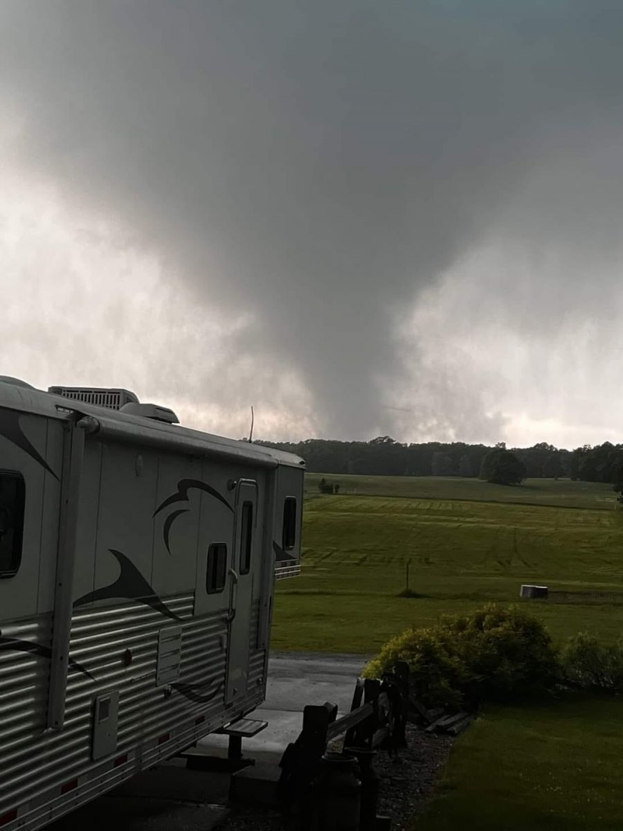
A view of the Wolford to Rabbit Lake to Cedar Lake to Prescott Lake Tornado from near Highway 210 and County Road 32 west of Aitkin. This view is looking west between Rabbit lake and Cedar Lake. Photo courtesy of Adam Schneider.
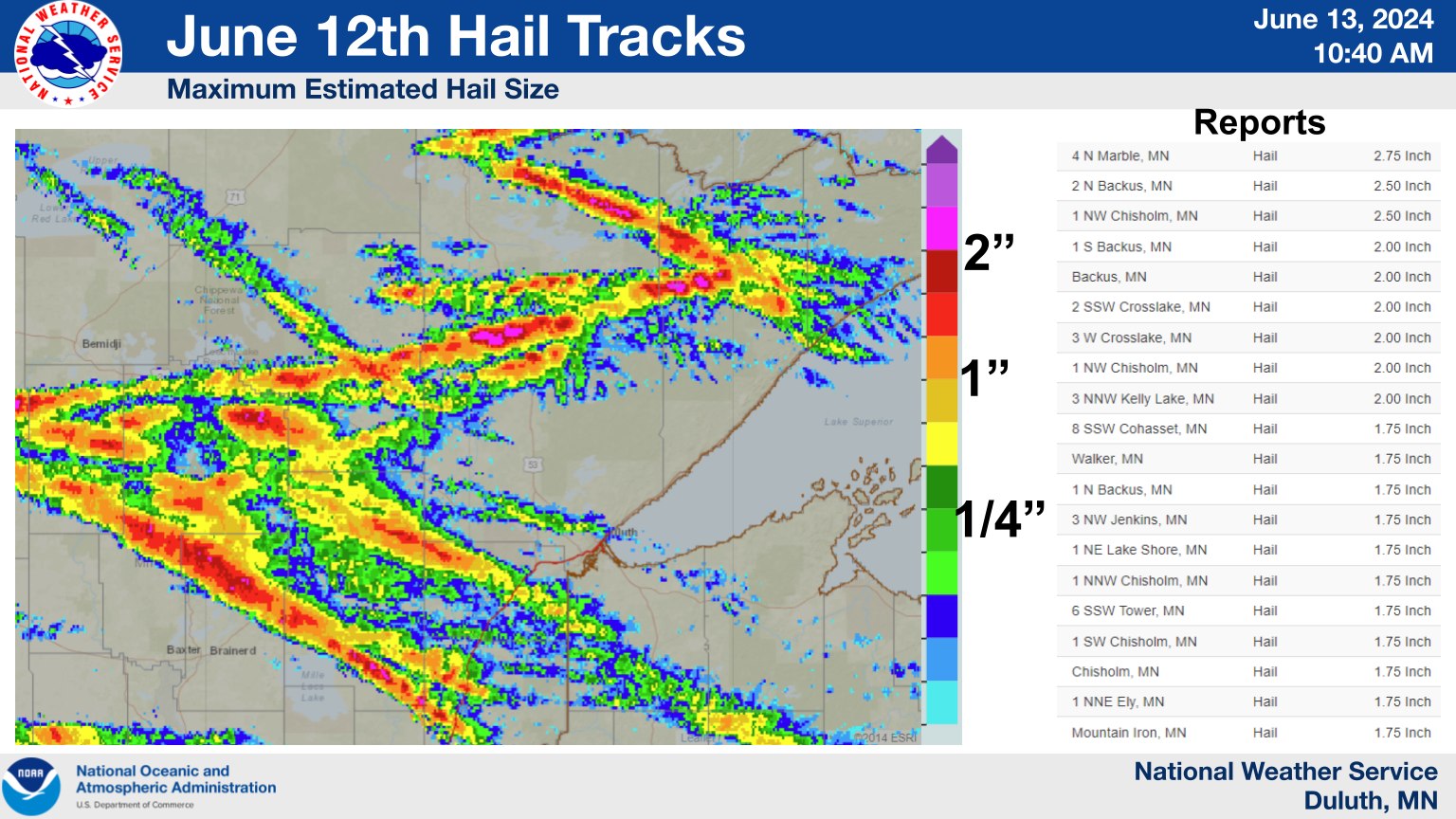
Maximum Radar Estimated Hail (MESH) tracks from supercells which dropped anywhere from hail the size of a quarter to nearly a baseball in the late afternoon to early evening overnight hours of Wednesday, June 12, 2024.
On Tuesday, June 18, 2024, a stationary surface front, in conjunction with an anomalously moist airmass, resulted in widespread flash flooding over the Northland. NWS Duluth issued seven Flash Flood Warnings (across much of NE MN and the Bayfield Peninsula), three of which were upgraded to include a considerable tag for life threatening flash flooding. Additionally, severe thunderstorms occurred ahead of the heaviest rainfall, prompting eight Tornado Warnings (near Ely and between Leech Lake and Grand Rapids) and 16 Severe Thunderstorm Warnings. Flash flooding extended from north-central Minnesota to the MN Arrowhead and across Lake Superior to the Bayfield Peninsula. River flooding would continue for weeks after the event, and high water in the Rainy River Basin headwaters would eventually lead to minor flooding after another round of heavy rain in early July. Furthermore, significant tree blowdowns occurred in the Superior National Forest due to damaging wind gusts associated with the storms.
For more information about this event, visit this webpage.
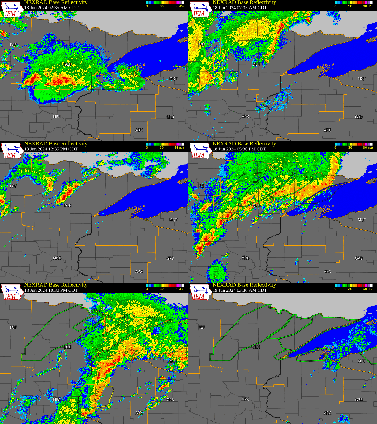
Radar imagery from June 18 at 4:00 AM to June 19 at 4:00 AM centered over northeastern Minnesota and northwestern Wisconsin. Imagery includes warning polygons for severe weather, flooding, and marine over Lake Superior. Image courtesy of Iowa State Environmental Mesonet.
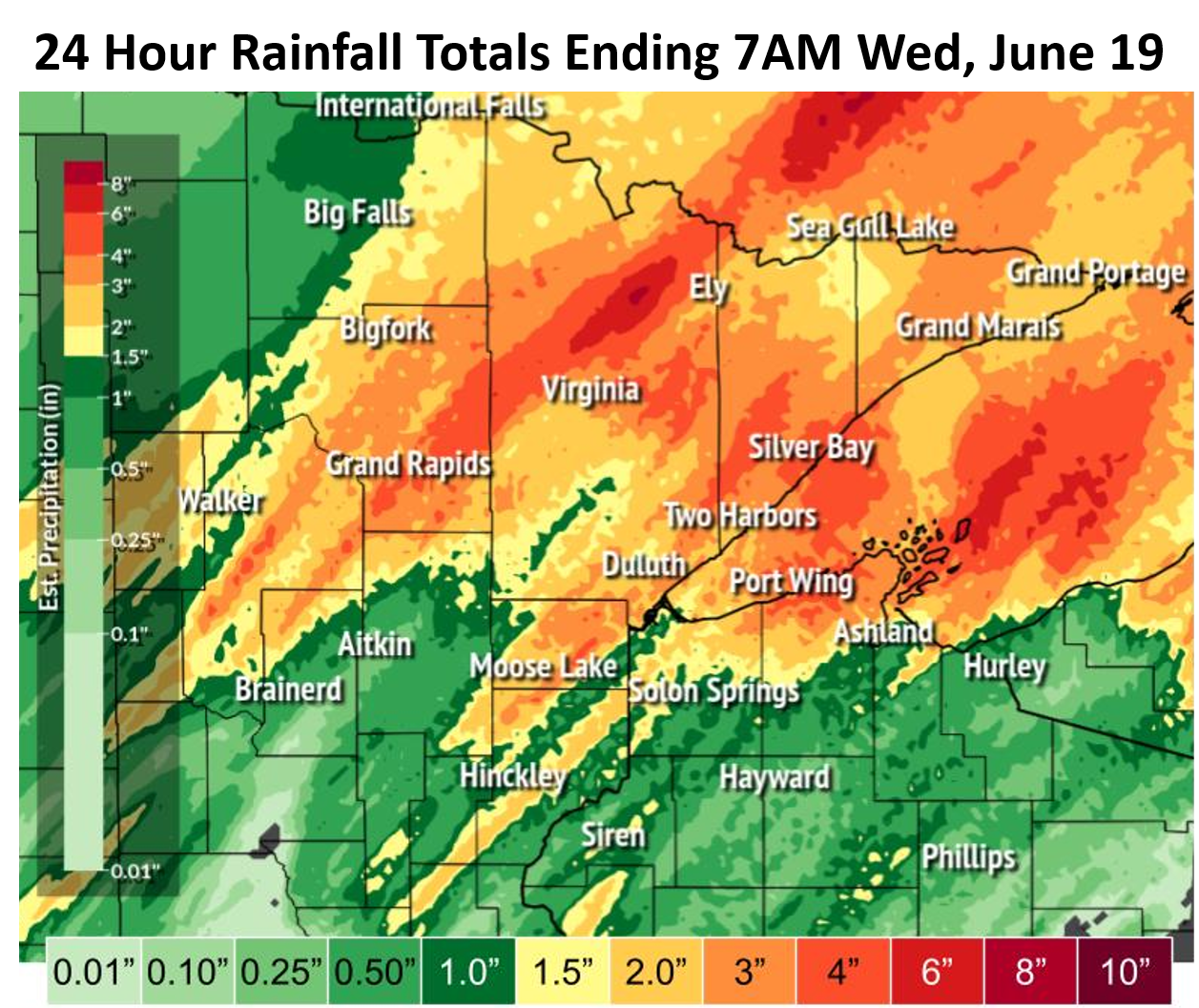
Rainfall totals ending in the morning of the 19th. Much of this fell in 8 hours or less in the afternoon and evening of June 18th.
Major flooding in downtown Cook, MN from the Littlefork River, the day after flash flooding occurred across the region. Photo courtesy of St. Louis County Emergency Management.
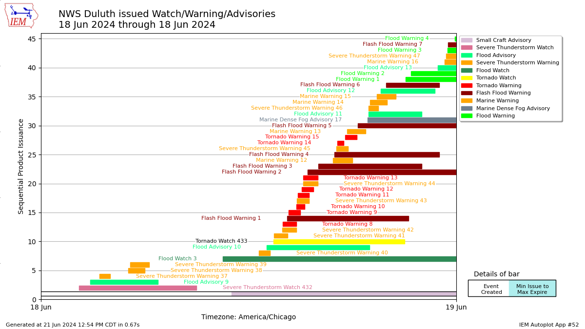
Timeline of Watch, Warning, and Advisory products issued for both severe thunderstorms and flooding on June 18, 2024. Image courtesy of Iowa State Environmental Mesonet.
 |
Media use of NWS Web News Stories is encouraged! Please acknowledge the NWS as the source of any news information accessed from this site. |
 |