|
Summary:
During the early morning hours of Friday, August 9th, 2024, the remnants of once-Hurricane Debby moved into PA from the south. The surface low passed over the central mountains of the state during the daylight hours. While the previously strong surface winds had died down to less than tropical storm force by that time, the storm produced torrential downpours and flooding and one tornado.
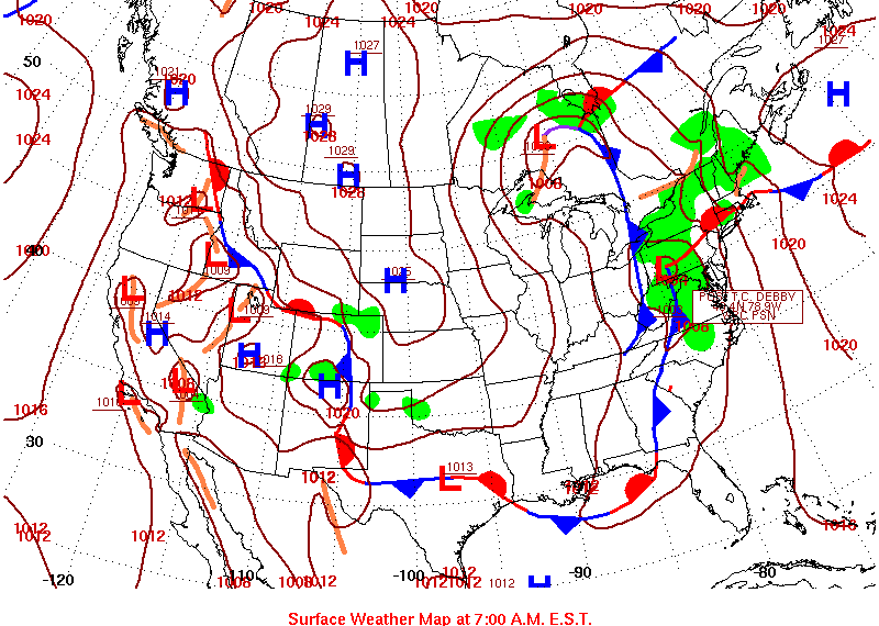
Surface Map 8 AM EDT 09 Aug 2024
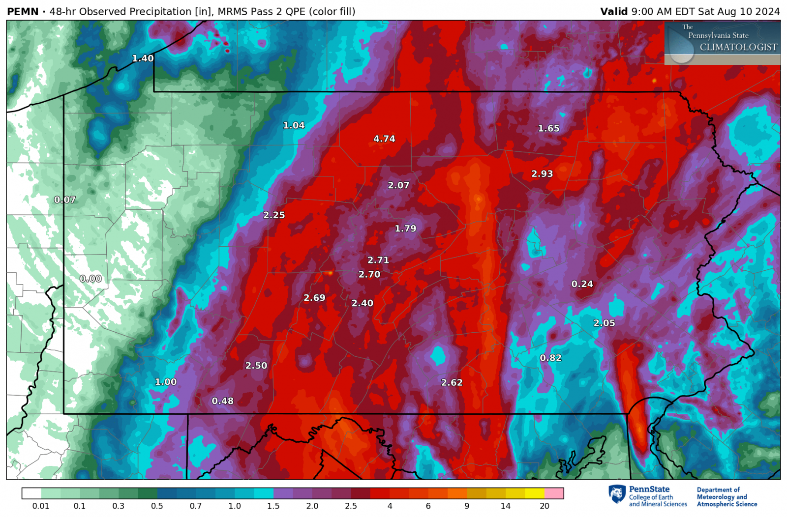
Rainfall:
Narrow bands of rain set up over parts of the area and produced more than 6 inches of rain in spots. Much of the region received between 2 and 4 inches of rainfall.
Flooding:
The most damaging flooding occurred in the mountains of far northern PA, along the Cowanesque River, in Westfield, Tioga County.
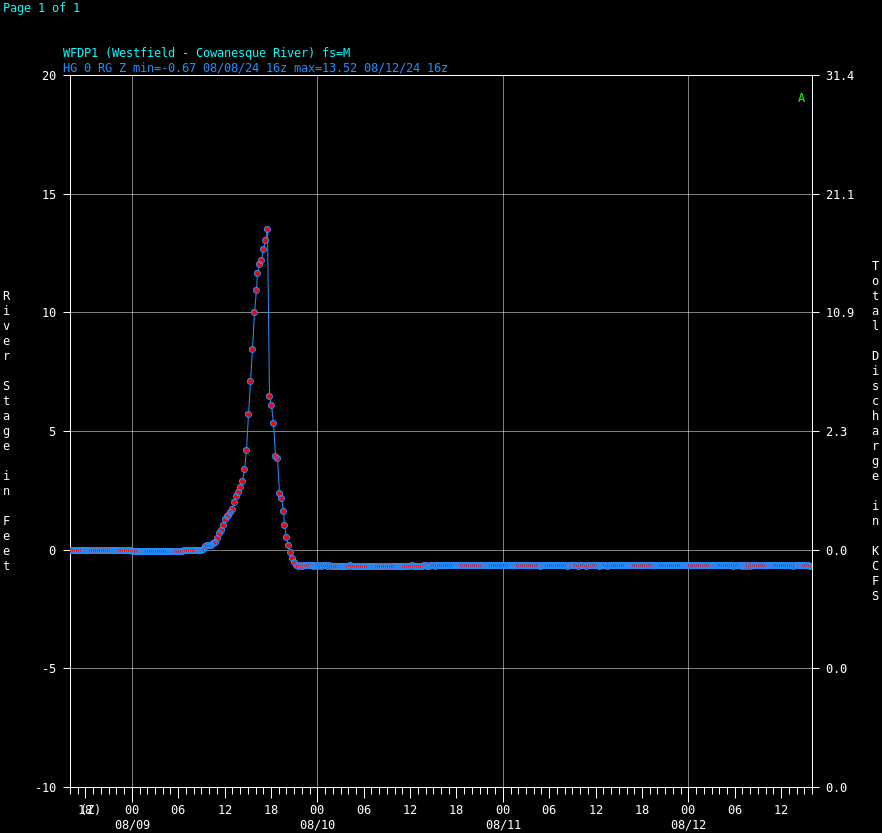
Cowanesque River at Westfield
Other locations across the region flooded, especially the smaller creeks and streams. Many of the larger rivers rose more-slowly and did not hit flood stages. (download for full size images)
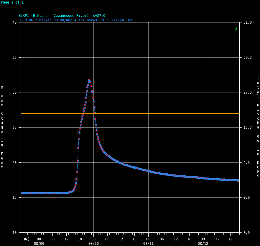
Cowanesque River at Elkland |
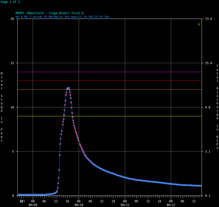
Tioga River at Mansfield |
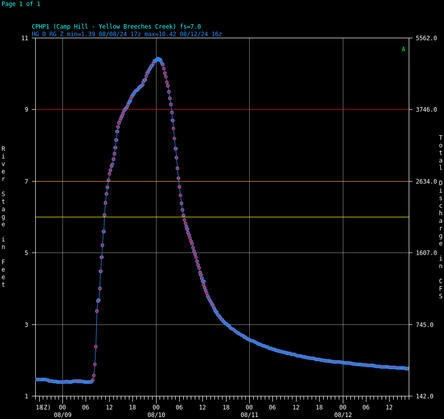
Yellow Breeches Creek at Camp Hill |
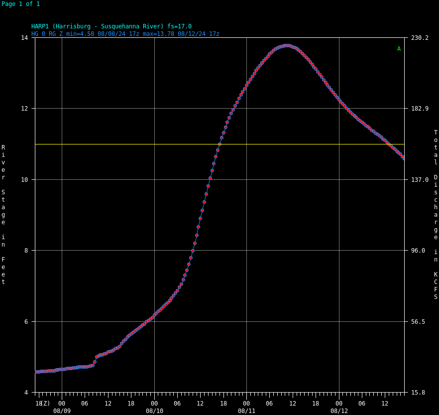
Susquehanna River at Harrisburg |
The Norfolk Southern rail line north of Harrisburg (Millersburg, PA) was closed for some time due to flooding damage, as well.
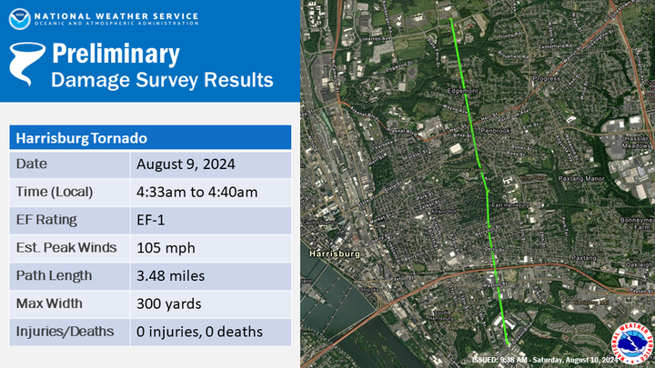
Tornado:
One tornado occurred in Central PA during the storm. The tornado's peak winds are estimated to be just above 100 MPH (EF1 strength). It occurred in the Harrisburg metro area before dawn. See the map and further information below. While some sporadic wind damage occurred elsewhere across Central PA, the tornado was the place of most-concentrated damage. It looks like it is the just second tornado in Harrisburg city limits since 1950. The last was an EF1 on April 30, 1994. Another EF1 came near city limits on May 11, 1996 just northeast of Arsenal Boulevard.
Public Information Statement
National Weather Service State College PA
941 PM EDT Fri Aug 9 2024


...NWS Damage Survey for August 9, 2024 Tornado Event...

.Harrisburg Tornado...

Rating:                 EF1
Estimated Peak Wind:    105 mph
Path Length /statute/:  3.48 miles
Path Width /maximum/:   300 yards
Fatalities:             0
Injuries:               0

Start Date:             08/09/2024
Start Time:             04:33 AM EDT
Start Location:         2 NW Steelton / Dauphin County / PA
Start Lat/Lon:          40.2457 / -76.8473

End Date:               08/09/2024
End Time:               04:40 AM EDT
End Location:           1 W Progress / Dauphin County / PA
End Lat/Lon:            40.2952 / -76.8586

Survey Summary:
Post Tropical Depression Debby produced a tornado in Dauphin
County in the early morning on Friday August 9th. The tornado
began along Gibson Avenue where it blew in a set of overhead doors
at a warehouse on the corner of Bobali Drive. As the tornado moved
north, it produced sporadic tree damage before causing significant
damage to the roof of Brethren in Christ Church on Derry Street. A
house on Berryhill Street had its roof partially blown off and
several trees were uprooted in its vicinity. Additional tree
damage occured in the 2200-2300 blocks of Central, Kensington,
McCleaster, and Swatara Streets as the tornado continued its
treck northward.

Some of the most significant damage from the tornado occured in
Bellevue Park where a few dozen trees were uprooted or snapped
off. A couple houses sustained significant roof and structural
damage as a result of trees falling on them in the vicinity of
Midland Rd, Bellevue Rd, and Pentwater Rd. The tornado then
crossed Market Street, producing sporadic tree damage on the
property of the Civil War Museum and northward to East Harrisburg
Cemetery on Herr Street, where multiple trees were uprooted. The
tornado continued northward into Susquehanna Township, producing
sporadic damage along a continuous track. The last observable
damage along the tornado's path occurred north of Elmerton Avenue
near the entrance to Pennsylvania State Police Headquarters.

NWS State College would like to thank Bob Stout and the Dauphin
County Office of Emergency Management for their support and
coordination as we worked together to complete the damage survey.

EF Scale: The Enhanced Fujita Scale classifies tornadoes into the
following categories:

EF0.....65 to 85 mph
EF1.....86 to 110 mph
EF2.....111 to 135 mph
EF3.....136 to 165 mph
EF4.....166 to 200 mph
EF5.....>200 mph

NOTE:
The information in this statement is preliminary and subject to
change pending final review of the event and publication in
NWS Storm Data.
|
|


 Send Us a Report