Overview
|
A high-impact, multi-hazard storm system impacted much of the United States in the days leading up to the Christmas Holiday which resulted in extreme cold, high winds, and hazardous conditions from blowing and drifting snow. Actual temperatures fell from as high as 40 degrees Thursday night ahead of the cold front to near 0 or even sub-zero by Friday morning, resulting in any rain remaining on the ground immediately freezing (i.e. "Flash Freeze"). Wind chills across the region bottomed out as low as -30°F to -35°F on Dec 23 (Friday and Friday night) while winds gusted as high as hurricane-force (74 mph) at one point along the Lake Erie shoreline. The extreme cold continued through the Christmas weekend, with persistent sub-zero wind chills and gusty winds. Although snow amounts were nothing out of the ordinary, ranging from generally 2 to 4 inches across the area, the gusty winds and the fluffy, dry nature of the snow allowed for efficient blowing and drifting, resulting in greatly-reduced visibility at times, especially on Dec 23 (Friday morning and afternoon). The blowing snow also resulted in blizzard conditions across parts of northern Ohio and northwestern PA, including in Cleveland and Erie. This was the first Blizzard Warning the WFO CLE office has issued in nearly 10 years. |
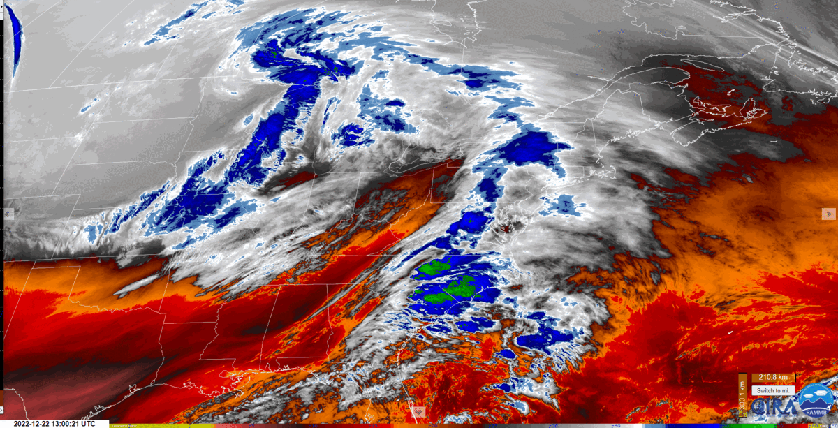 Low-level water vapor loop from Thursday, Dec 22 7 AM through Sunday, Dec 25 7 AM. |
Photos & Video
 |
 |
 |
 |
| Photo of the exposed lake floor as a result of extremely low water levels across the western basin of Lake Erie. (Barry Koehler) |
Photo of the exposed lake floor with Perry Monument in the background as a result of extremely low water levels across the western basin of Lake Erie. (Barry Koehler) |
Photo of Miller Ferries resting on the Lake floor as a result of the extremely low water levels on the western basin of Lake Erie. (Miller Ferries) |
Photo of freezing spray from Euclid Beach. (Laura Victoria) |
 |
 |
 |
.jpg) |
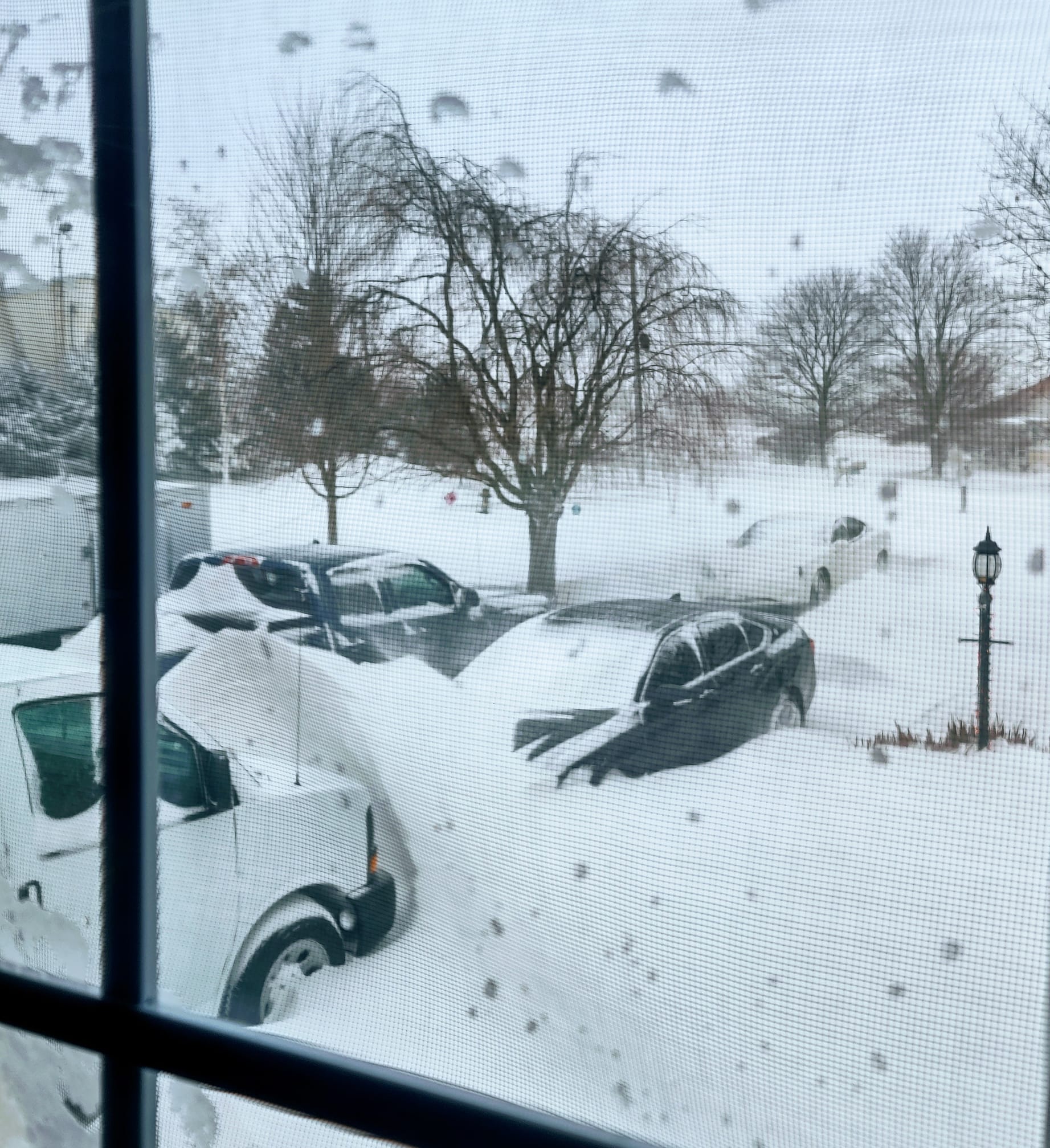
| Whiteout conditions near New Washington, Crawford County, OH. (Anthony Haga) |
Whiteout conditions in the Cleveland area. (Kurt Voelkel) |
Photo of large snow drifts in Avery, OH. (Tony Lewis) |
Photo of plowed drifts in Shelby, OH. (Wendy Rodenbaugh) |
 |
 |
 |
 |
| Downed pine tree from strong winds in Kirtland, OH. (Chad Wacha) | Photo of ambulance on West 25th Street in Cleveland, OH. The back was covered in ice. (CARE-1975) | Photo of snow drifts in Ashtabula, OH. (Erin Buckley Arsulic) | Photo of blowing snow across the Edison Bridge in Marblehead, OH. (Denise Richmond Mcmanamon) |
 |
 |
 |
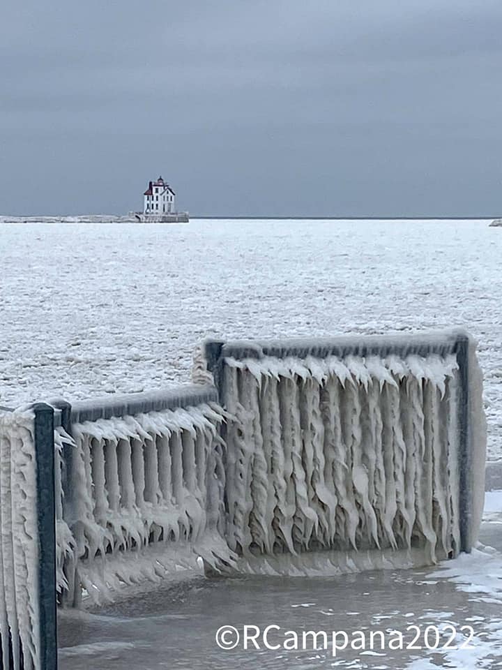 |
| Shoreline debris and high waves at Freeport Beach in North East, PA. (Kimberly Russell) | Snow drifts among 8' poly houses at Cottage Gardens in Perry, OH. (Nick Hayes) | Photo shows ice forming at Wildwood Marina in Cleveland, OH. (Laura Victoria) | Photo of Lorain Lighthouse off of Mile Long Pier in Lorain, OH and the ice accumulation on the pier. (Robert Campana) |
Radar
 |
| Radar loop from early Friday morning through Friday afternoon (Dec 23, 2022). |
Surface Observations
 |
 |
 |
 |
| Visibility and wind gust observations from Wayne County airport. Gray shading indicates periods of blizzard like conditions. | Visibility and wind gust observations from Burke Lakefront airport. Blue shading indicates 3 or more hours of blizzard conditions. | Visibility and wind gust observations from Akron Canton airport. Blue shading indicates 3 or more hours of blizzard conditions. | Visibility and wind gust observations from Cleveland Hopkins airport. Blue shading indicates 3 or more hours of blizzard conditions. |
 |
 |
 |
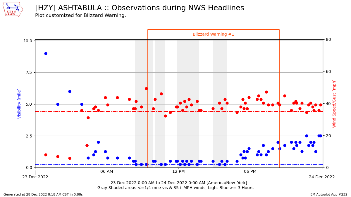 |
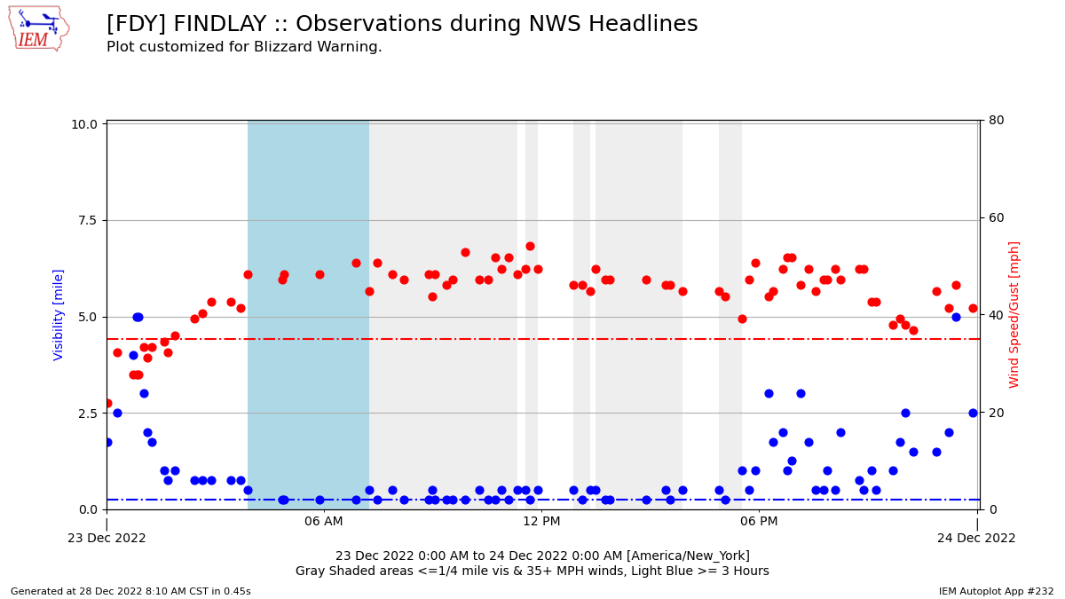
| Visibility and wind gust observations from Erie airport. Blue shading indicates 3 or more hours of blizzard conditions. | Visibility and wind gust observations from Findlay airport. Blue shading indicates 3 or more hours of blizzard conditions. | Visibility and wind gust observations from Meadville airport. Gray shading indicates periods of blizzard like conditions. | Visibility and wind gust observations from Ashtabula County airport. Gray shading indicates periods of blizzard like conditions. |
 |
 |
 |
 |
| Visibility and wind gust observations from Lost Nation airport in Willoughby. Blue shading indicates 3 or more hours of blizzard conditions. | Visibility and wind gust observations from Lorain County airport. Blue shading indicates 3 or more hours of blizzard conditions. | Visibility and wind gust observations from Mansfield airport. Gray shading indicates periods of blizzard like conditions. | Visibility and wind gust observations from Marion County airport. Gray shading indicates periods of blizzard like conditions. Note that observations stopped during the early morning hours of December 23rd. |
 |
 |
 |
 |
| Visibility and wind gust observations from Port Clinton airport. Blue shading indicates 3 or more hours of blizzard conditions. | Visibility and wind gust observations from Toledo Executive airport. Gray shading indicates periods of blizzard like conditions. | Visibility and wind gust observations from Toledo Express airport. Gray shading indicates periods of blizzard like conditions. | Visibility and wind gust observations from Youngstown-Warren airport. Blue shading indicates 3 or more hours of blizzard conditions. |
Storm Reports
 |
| NOHRSC 72-hour snowfall analysis from Thursday, Dec 22 7 AM through Sunday, Dec 25 7 AM. |
***These totals do not include any additional lake effect snow the
area received the night of December 24th into December 25th. ***

Public Information Statement
Spotter Reports
National Weather Service Cleveland OH
1143 AM EST Sat Dec 24 2022

The following are observations taken from the storm that has been
affecting our region since Thursday night. Appreciation is extended
to highway departments, cooperative observers, Skywarn spotters, and
media for these reports. This summary also is available on our home
page at weather.gov/cleveland

********************STORM TOTAL SNOWFALL********************

LOCATION                TOTAL      TIME/DATE  COMMENTS
                     SNOWFALL       MEASURED
                     (inches)

OHIO

...Ashland County...
  3 WSW Hayesville        2.0   800 AM 12/23  Trained Spotter
  4 SW Ashland            1.0   700 AM 12/23  CoCoRaHS

...Ashtabula County...
  2 ESE Monroe Center     6.0   600 PM 12/23  Trained Spotter
  3 E South Madison       4.3   750 PM 12/23  Trained Spotter
  Edgewood                3.8   715 AM 12/24  Trained Spotter
  3 W Ashtabula           3.0   700 PM 12/23  Trained Spotter
  SE Ashtabula            3.0   700 AM 12/23  CoCoRaHS
  2 N Cherry Valley       3.0   733 PM 12/23  Trained Spotter
  2 ESE Pierpont          3.0   846 AM 12/23  Trained Spotter
  3 ENE Trumbull          2.0   800 AM 12/23  Trained Spotter
  2 S Harpersfield        2.0   904 AM 12/23  Trained Spotter
  1 WSW Conneaut          1.5   543 PM 12/23  Trained Spotter
  1 ESE Ashtabula         1.2  1020 AM 12/23  Trained Spotter
  2 NNW Cherry Valley     1.0   745 AM 12/23  Trained Spotter
  1 E Orwell              0.2   700 AM 12/24  Trained Spotter

...Crawford County...
  3 WSW Tiro              3.0   631 PM 12/23  Trained Spotter

...Cuyahoga County...
  1 W Shaker Heights      5.0   930 PM 12/23  Trained Spotter
  1 ENE Lyndhurst         5.0   853 AM 12/23  Trained Spotter
  1 NNE Seven Hills       5.0   800 AM 12/24  CoCoRaHS
  ESE South Euclid        4.9  1030 AM 12/23  CoCoRaHS
  Highland Heights        4.5   930 AM 12/23  Trained Spotter
  2 NNW Parma             4.4   800 AM 12/24  CoCoRaHS
  1 W Chagrin Falls       4.4   915 AM 12/23  Trained Spotter
  1 NNE North Royalton    4.0   700 AM 12/23  Trained Spotter
  2 SW Cleveland-Tremo    4.0   800 AM 12/23  Trained Spotter
  1 SSW Westlake          3.6   800 AM 12/24  CoCoRaHS
  1 SE Strongsville       3.5   800 AM 12/24  CoCoRaHS
  1 SSW Lakewood          3.5   700 AM 12/23  CoCoRaHS
  Westlake                3.4   800 PM 12/23  Trained Spotter
  2 SSW Rocky River       3.1   800 AM 12/23  CoCoRaHS
  1 ESE Broadview Heig    2.3   640 PM 12/23  Trained Spotter
  2 NE Euclid             2.0   840 AM 12/23  Trained Spotter
  1 WSW Cleveland Heig    1.8   700 PM 12/23  Trained Spotter
  Seven Hills             0.8   700 PM 12/23  Trained Spotter

...Erie County...
  Huron                   3.0   630 PM 12/23  Trained Spotter
  N Berlin Heights        2.5   700 AM 12/23  CoCoRaHS
  6 SW Vermilion          1.5   700 AM 12/23  CoCoRaHS
  ENE Milan               1.2   800 AM 12/23  CoCoRaHS
  2 NNE Castalia          1.0   630 AM 12/24  CoCoRaHS
  3 ESE Huron             0.7   800 AM 12/23  CoCoRaHS

...Geauga County...
  2 W South Thompson      6.5   700 AM 12/24  Trained Spotter
  2 W Burton              4.0   930 AM 12/24  Trained Spotter
  3 SW Chardon            4.0   730 PM 12/23  Trained Spotter
  3 WSW Auburn Corners    3.3   900 AM 12/24  Trained Spotter
  1 S Montville           2.0   800 AM 12/23  Trained Spotter
  1 SSE Montville         2.0   800 AM 12/23  CoCoRaHS
  1 E Chardon             1.5   800 AM 12/23  Co-Op Observer
  1 NE Middlefield        0.2   800 AM 12/23  CoCoRaHS

...Hancock County...
  WSW Findlay             2.3   700 AM 12/24  CoCoRaHS

...Holmes County...
  4 E Killbuck            0.3   815 AM 12/23  Trained Spotter

...Huron County...
  3 NW New London         3.7   600 AM 12/24  Trained Spotter

...Knox County...
  WNW Mount Vernon        2.0   800 AM 12/24  CoCoRaHS
  4 NNW Fredericktown     1.2   700 AM 12/23  CoCoRaHS
  2 SE Centerburg         0.4   800 AM 12/23  Co-Op Observer

...Lake County...
  North Madison           5.3   727 AM 12/24  Trained Spotter
  1 SSE Mentor            5.3   700 PM 12/23  Trained Spotter
  3 SW Willoughby         4.8   700 AM 12/24  CoCoRaHS
  1 SE Concord            4.7   726 AM 12/24  Trained Spotter
  Willowick               4.0   800 AM 12/23  Trained Spotter
  2 SSW Mentor-On-the-    4.0   700 PM 12/23  Trained Spotter
  1 E Mentor              4.0   826 AM 12/23  Trained Spotter
  1 NW Concord            4.0   900 AM 12/23  Trained Spotter
  2 WNW Concord           3.5   920 PM 12/23  Trained Spotter
  2 ESE Mentor            3.4  1000 AM 12/23  Trained Spotter
  1 N Madison             3.0   800 PM 12/23  Trained Spotter
  1 NNE Kirtland Hills    2.5   720 PM 12/23  Trained Spotter
  1 WSW Madison           2.0   700 AM 12/23  Trained Spotter
  1 SSE Wickliffe         2.0   745 AM 12/23  Trained Spotter

...Lorain County...
  1 ENE Oberlin           3.7   740 AM 12/24  Trained Spotter
  3 NE North Ridgevill    3.5   700 AM 12/24  CoCoRaHS
  Elyria                  3.1   430 AM 12/24  Trained Spotter
  1 S Oberlin             3.0   800 AM 12/23  Co-Op Observer
  6 SW Wellington         2.5   800 AM 12/23  CoCoRaHS
  SE Elyria               2.3   430 AM 12/24  CoCoRaHS
  2 NE North Ridgevill    2.2  1009 AM 12/23  Trained Spotter
  1 NW Avon               2.0   700 AM 12/23  CoCoRaHS

...Lucas County...
  7 NNE Swanton           4.5   700 AM 12/24  CoCoRaHS
  2 NNE Waterville        2.5   900 AM 12/24  CoCoRaHS
  3 SSW Oregon            2.0   800 AM 12/24  CoCoRaHS
  3 ESE Toledo            2.0   303 AM 12/24  CoCoRaHS
  3 N Holland             0.9   800 PM 12/23  Trained Spotter

...Mahoning County...
  1 NW Austintown         2.6   910 AM 12/23  Trained Spotter
  Canfield                2.5   900 AM 12/24  Trained Spotter
  1 N Canfield            2.5   845 AM 12/24  CoCoRaHS
  1 NNW Canfield          1.5   900 AM 12/23  Trained Spotter
  2 NW Youngstown         0.5  1130 AM 12/23  Trained Spotter

...Marion County...
  Marion                  2.5   700 PM 12/23  Trained Spotter
  4 SSE Marion            1.0   700 AM 12/23  CoCoRaHS

...Medina County...
  1 ENE Medina            3.8   730 AM 12/24  CoCoRaHS
  1 NE Brunswick          3.6   700 AM 12/23  CoCoRaHS
  1 ENE Brunswick         3.6   700 PM 12/23  Trained Spotter
  2 ESE Hinckley          3.0   630 PM 12/23  Trained Spotter
  5 WNW Wadsworth         2.8   500 AM 12/24  CoCoRaHS
  2 SSE Sharon Center     2.6   700 PM 12/23  Trained Spotter
  2 E Spencer             1.9   815 AM 12/24  CoCoRaHS
  2 E Homerville            T   915 AM 12/24  Trained Spotter

...Morrow County...
  5 ESE Mount Gilead      0.5   600 AM 12/24  CoCoRaHS

...Ottawa County...
  3 N Gypsum              2.0  1000 AM 12/23  Trained Spotter

...Portage County...
  Hiram                   3.0   900 AM 12/24  Trained Spotter
  N Hiram                 3.0   700 AM 12/24  CoCoRaHS
  1 NNW Mantua            3.0   800 AM 12/24  CoCoRaHS
  1 W Kent                2.5  1030 AM 12/23  Trained Spotter
  4 NE Kent               2.5   800 AM 12/23  CoCoRaHS
  1 ENE Mogadore          2.0   656 AM 12/23  Trained Spotter
  3 S Ravenna             1.5   700 AM 12/24  CoCoRaHS
  2 NW Rootstown          1.0   909 AM 12/23  Trained Spotter
  2 NW Streetsboro        0.8   715 AM 12/23  CoCoRaHS
  1 W Craig Beach         0.7   700 AM 12/24  Co-Op Observer
  2 W Kent                0.5   700 AM 12/24  CoCoRaHS

...Richland County...
  1 NNE Shelby            6.0   900 AM 12/24  Trained Spotter
  7 ENE Mansfield         4.0   800 AM 12/24  CoCoRaHS
  1 ENE Lexington         3.5   700 AM 12/24  CoCoRaHS
  1 W Mansfield           3.0   945 AM 12/24  Trained Spotter
  1 NW Lexington          2.5   800 AM 12/24  CoCoRaHS
  5 NW Mifflin            2.1   730 PM 12/23  Trained Spotter
  5 WSW Mansfield         2.0  1100 AM 12/23  CoCoRaHS

...Seneca County...
  4 S Old Fort            2.0   515 PM 12/23  Trained Spotter
  2 NNW Mexico            1.0   900 AM 12/23  Trained Spotter

...Stark County...
  1 NE Canton             3.0   947 AM 12/23  Trained Spotter
  3 NW Waynesburg         2.9   548 PM 12/23  Trained Spotter
  4 S Alliance            1.0   756 AM 12/23  Trained Spotter
  4 W North Canton        1.0   800 AM 12/23  Trained Spotter

...Summit County...
  1 NNE Bath              4.9   700 PM 12/23  Trained Spotter
  Reminderville           4.5  1000 AM 12/24  Trained Spotter
  1 N Bath                4.1   700 AM 12/24  Trained Spotter
  3 SSW Barberton         4.0   800 AM 12/24  Trained Spotter
  1 NW Tallmadge          3.7   800 PM 12/23  Trained Spotter
  1 SE Sagamore Hills     3.3   830 AM 12/23  Trained Spotter
  1 SW Munroe Falls       3.0   700 AM 12/24  Co-Op Observer
  1 ESE Cuyahoga Falls    1.6   700 AM 12/23  CoCoRaHS
  2 SE Cuyahoga Falls     1.5   830 AM 12/23  Trained Spotter
  1 NNE Tallmadge         1.4   116 PM 12/23  CoCoRaHS

...Trumbull County...
  1 N Newton Falls        4.0   700 AM 12/24  CoCoRaHS
  1 WNW Newton Falls      4.0   700 AM 12/24  Trained Spotter
  3 SE Gustavus           2.6   700 PM 12/23  Trained Spotter
  Cortland                2.6   530 PM 12/23  Trained Spotter
  Mosquito Creek Lake     0.8   700 AM 12/24  Co-Op Observer

...Wayne County...
  3 ENE Doylestown        2.0   700 AM 12/23  Trained Spotter
  2 SW Kidron             1.0   700 AM 12/23  Trained Spotter

...Wood County...
  2 WSW Perrysburg        2.0   500 AM 12/24  CoCoRaHS
  2 WSW Pemberville       2.0   530 PM 12/23  Trained Spotter
  2 E Bowling Green       1.2  1200 AM 12/24  Co-Op Observer

...Wyandot County...
  4 NW Harpster           2.5   800 AM 12/23  Trained Spotter

PENNSYLVANIA

...Crawford County...
  6 E Atlantic            4.2   830 PM 12/23  Trained Spotter
  3 WNW Springboro        4.2   700 AM 12/24  Co-Op Observer
  1 NNE Meadville         3.5   420 PM 12/23  Trained Spotter
  1 S Meadville           3.4   902 AM 12/23  Trained Spotter
  1 WNW Conneaut Lake     2.4   700 AM 12/24  CoCoRaHS
  3 SE Townville          2.1   730 PM 12/23  Trained Spotter
  3 NE Cochranton         1.3   730 AM 12/24  Trained Spotter
  7 NW Meadville          0.1   700 AM 12/23  CoCoRaHS

...Erie County...
  2 ESE North East        8.8   700 AM 12/24  Trained Spotter
  2 NW Edinboro           4.0   500 AM 12/24  Trained Spotter
  2 W Avonia              3.2   720 PM 12/23  Trained Spotter
  2 SSW Corry             2.0   900 AM 12/23  Trained Spotter
  2 E Edinboro            1.7   800 AM 12/24  Trained Spotter
  2 ESE Erie              1.0   700 AM 12/24  Trained Spotter
  1 NNW Corry             0.5   730 AM 12/23  CoCoRaHS
  2 WSW Erie              0.3   530 PM 12/23  Trained Spotter
  1 WNW North East        0.1   800 AM 12/23  CoCoRaHS
Public Information Statement
National Weather Service Cleveland OH
1215 PM EST Sat Dec 24 2022

...MINIMUM WIND CHILL REPORTS...

Location                     WC Temp.  Time/Date       Lat/Lon

...Ohio...

...Ashland County...
Ashland                      -41 F     1135 AM 12/23   40.86N/82.32W
Ashland                      -32 F     1129 AM 12/23   40.83N/82.38W
Perrysville                  -30 F     1059 AM 12/23   40.65N/82.31W

...Ashtabula County...
Ashtabula                    -29 F     0535 PM 12/23   41.78N/80.70W
1 E Geneva-on-the-Lake       -22 F     0345 PM 12/23   41.86N/80.92W
Ashtabula                    -22 F     0640 PM 12/23   41.78N/80.82W
Harpersfield                 -21 F     0730 PM 12/23   41.73N/80.99W

...Crawford County...
Crestline                    -23 F     0636 PM 12/23   40.79N/82.75W

...Cuyahoga County...
1 W Linndale                 -34 F     1115 AM 12/23   41.45N/81.79W
1 NNW Cleveland              -34 F     1230 PM 12/23   41.50N/81.69W
Cleveland                    -34 F     1151 AM 12/23   41.42N/81.85W
Shaker Heights               -33 F     1222 PM 12/23   41.47N/81.52W
1 SSE Rocky River            -33 F     0125 PM 12/23   41.46N/81.85W
Parma                        -32 F     0250 PM 12/23   41.37N/81.70W
Clevlnd Cuyahoga             -32 F     1245 PM 12/23   41.57N/81.47W
Fairview High School         -31 F     0600 PM 12/23   41.44N/81.86W
University Heights           -31 F     0235 PM 12/23   41.49N/81.53W
Parma                        -30 F     0815 PM 12/23   41.37N/81.71W
Cleveland                    -30 F     1153 AM 12/23   41.52N/81.68W
Brook Park                   -29 F     1232 PM 12/23   41.39N/81.79W
Solon                        -28 F     1011 AM 12/23   41.38N/81.47W
1 NNE Cleveland              -27 F     1155 AM 12/23   41.50N/81.67W
1 ENE Westlake               -24 F     1230 PM 12/23   41.46N/81.91W
Shaker Heights               -22 F     0109 PM 12/23   41.48N/81.52W
Cleveland                    -22 F     0559 PM 12/23   41.44N/81.82W
Olmsted Falls                -22 F     1045 AM 12/23   41.36N/81.92W
Middleburg Heights           -22 F     0245 PM 12/23   41.35N/81.80W
Lakewood                     -21 F     1145 AM 12/23   41.48N/81.80W
Cleveland                    -21 F     0635 PM 12/23   41.44N/81.73W
Stongsville                  -20 F     1146 AM 12/23   41.33N/81.81W

...Erie County...
Sandusky                     -31 F     1200 PM 12/23   41.38N/82.64W
Sandusky                     -30 F     1148 AM 12/23   41.44N/82.64W
Vermilion                    -25 F     0105 PM 12/23   41.42N/82.37W
Huron                        -23 F     0745 PM 12/23   41.38N/82.46W

...Geauga County...
Munson Twp                   -33 F     0145 PM 12/23   41.51N/81.18W
Bainbridge                   -30 F     1215 PM 12/23   41.39N/81.39W
Chardon                      -29 F     0148 PM 12/23   41.50N/81.24W
NOVELTY                      -28 F     0317 PM 12/23   41.50N/81.34W
Auburn                       -27 F     1230 PM 12/23   41.36N/81.27W
Auburn Township              -26 F     0805 PM 12/23   41.39N/81.24W
Thompson Twp                 -22 F     0905 PM 12/23   41.69N/81.09W

...Hancock County...
Arcadia                      -42 F     1015 AM 12/23   41.12N/83.52W
Findlay                      -38 F     1045 AM 12/23   41.04N/83.55W
Jenera                       -36 F     0915 AM 12/23   40.94N/83.75W
Findlay                      -36 F     0953 AM 12/23   41.02N/83.67W
Van Buren                    -34 F     1005 AM 12/23   41.14N/83.65W

...Holmes County...
Holmes County Airport        -34 F     1155 AM 12/23   40.54N/81.96W

...Huron County...
Bellevue                     -36 F     0305 PM 12/23   41.24N/82.77W
New London                   -29 F     1101 AM 12/23   41.09N/82.44W
North Fairfield              -28 F     0340 PM 12/23   41.12N/82.62W

...Knox County...
Mt Vernon Knox               -35 F     0955 AM 12/23   40.33N/82.53W
Centerburg                   -33 F     0932 AM 12/23   40.30N/82.64W

...Lake County...
Wickliffe                    -33 F     1209 PM 12/23   41.60N/81.48W
Mentor                       -33 F     1240 PM 12/23   41.70N/81.34W
Fairport, OH                 -33 F     0230 PM 12/23   41.76N/81.28W
Willoughby                   -31 F     0155 PM 12/23   41.67N/81.37W
Mentor                       -29 F     0225 PM 12/23   41.67N/81.33W
Mentor                       -25 F     0240 PM 12/23   41.73N/81.31W
Mentor                       -25 F     0835 PM 12/23   41.64N/81.31W
Kirtland                     -22 F     0347 PM 12/23   41.61N/81.33W
Mentor                       -21 F     0800 PM 12/23   41.72N/81.35W
WICKLIFFE                    -20 F     0239 PM 12/23   41.60N/81.47W

...Lorain County...
Kipton                       -34 F     1020 AM 12/23   41.24N/82.29W
Lorain                       -34 F     1115 AM 12/23   41.49N/82.12W
Avon                         -32 F     1056 AM 12/23   41.44N/82.05W
Lorain Elyria                -32 F     1253 PM 12/23   41.35N/82.18W
Wellington                   -29 F     0115 PM 12/23   41.16N/82.19W
Elyria                       -26 F     0317 PM 12/23   41.38N/82.10W
Avon Lake                    -24 F     0139 PM 12/23   41.50N/82.05W
Avon                         -23 F     1100 AM 12/23   41.45N/82.03W
Lorain                       -23 F     1059 AM 12/23   41.47N/82.19W
AVON LAKE                    -23 F     0220 PM 12/23   41.49N/81.99W
Amherst                      -22 F     1045 AM 12/23   41.39N/82.28W

...Lucas County...
2 SSE Ottawa Hills           -36 F     1055 AM 12/23   41.63N/83.63W
1 NNE Ottawa Hills           -31 F     0945 AM 12/23   41.69N/83.63W
2 E Toledo                   -31 F     1100 AM 12/23   41.65N/83.53W
Toledo                       -29 F     1032 AM 12/23   41.58N/83.80W
Toledo, OH                   -29 F     1112 AM 12/23   41.69N/83.47W
2 NNE Toledo                 -28 F     1250 PM 12/23   41.70N/83.56W
1.5 W Ottawa Hills (WEATHERS -24 F     1200 PM 12/23   41.67N/83.67W
Maumee                       -24 F     1149 AM 12/23   41.60N/83.71W
Curtice                      -23 F     1110 PM 12/23   41.66N/83.25W
Waterville                   -21 F     0120 PM 12/23   41.46N/83.82W

...Mahoning County...
Youngstown                   -25 F     0550 PM 12/23   41.10N/80.65W
New Middletown               -24 F     0257 PM 12/23   40.97N/80.55W
Youngstown                   -20 F     0228 PM 12/23   41.05N/80.69W

...Marion County...
Marion                       -36 F     0900 AM 12/23   40.58N/83.07W
Marion                       -26 F     1145 AM 12/23   40.57N/83.11W

...Medina County...
1 W Brunswick                -38 F     1200 PM 12/23   41.25N/81.84W
Brunswick                    -36 F     0136 PM 12/23   41.23N/81.82W
Homerville                   -33 F     1135 AM 12/23   41.02N/82.10W
Valley City                  -31 F     1235 PM 12/23   41.21N/81.89W
Seville                      -27 F     1245 PM 12/23   41.03N/81.83W
3 N Rittman                  -26 F     1205 PM 12/23   41.02N/81.79W
Hinckley                     -25 F     0130 PM 12/23   41.23N/81.77W
Medina                       -25 F     1045 AM 12/23   41.14N/81.85W
Seville                      -22 F     1110 AM 12/23   41.00N/81.82W
Brunswick                    -22 F     1046 AM 12/23   41.25N/81.81W
Sharon Township              -22 F     1045 AM 12/23   41.08N/81.75W
Medina                       -20 F     0528 PM 12/23   41.17N/81.84W

...Morrow County...
6 SSE Galion                 -37 F     0940 AM 12/23   40.64N/82.76W
Marengo                      -28 F     1033 AM 12/23   40.39N/82.84W

...Ottawa County...
MARTIN                       -37 F     1139 AM 12/23   41.57N/83.33W
Port Clinton                 -36 F     1215 PM 12/23   41.52N/82.87W
Port Clinton                 -28 F     1030 AM 12/23   41.52N/82.99W
Port Clinton                 -28 F     1003 AM 12/23   41.51N/82.92W
Danbury Twp                  -26 F     1130 AM 12/23   41.53N/82.78W

...Portage County...
4 N Ravenna                  -30 F     0535 PM 12/23   41.22N/81.25W
Rootstown                    -29 F     0639 PM 12/23   41.10N/81.27W
3 SE Brimfield               -24 F     0510 PM 12/23   41.06N/81.31W
Ravenna                      -24 F     0125 PM 12/23   41.16N/81.28W

...Richland County...
Mansfield                    -36 F     1252 PM 12/23   40.82N/82.52W
Shelby                       -32 F     0126 PM 12/23   40.89N/82.66W
Shiloh                       -32 F     1128 AM 12/23   40.89N/82.46W
Mansfield                    -31 F     1106 AM 12/23   40.77N/82.52W

...Sandusky County...
Sandusky County Regional Air -37 F     0955 AM 12/23   41.30N/83.04W
Fremont                      -33 F     1100 AM 12/23   41.36N/83.12W
Fremont                      -32 F     1100 AM 12/23   41.40N/83.22W

...Seneca County...
1.9 W Tiffin (WEATHERSTEM)   -27 F     0700 AM 12/23   41.11N/83.21W
Tiffin                       -20 F     1015 AM 12/23   41.12N/83.17W

...Stark County...
Louisville                   -35 F     0245 PM 12/23   40.83N/81.24W
Canal Fulton                 -32 F     0115 PM 12/23   40.88N/81.53W
Hartville                    -29 F     0425 PM 12/23   40.98N/81.36W
Massillon                    -27 F     1000 PM 12/23   40.85N/81.51W
Canton                       -22 F     0325 PM 12/23   40.84N/81.45W

...Summit County...
Copley                       -31 F     0305 PM 12/23   41.07N/81.66W
Akron-Canton Regional Arpt   -31 F     0151 PM 12/23   40.92N/81.45W
Akron                        -30 F     0204 PM 12/23   41.08N/81.52W
Akron Fulton International A -30 F     0154 PM 12/23   41.03N/81.47W
Lakemore                     -30 F     0100 PM 12/23   41.02N/81.43W
Reminderville                -29 F     0247 PM 12/23   41.35N/81.39W
2 SSW Northfield             -28 F     1200 PM 12/23   41.31N/81.54W
Fairlawn                     -28 F     1220 PM 12/23   41.12N/81.60W
Cuyahoga Falls               -28 F     0430 PM 12/23   41.14N/81.52W
2 N Montrose-Ghent           -27 F     0200 PM 12/23   41.19N/81.64W
Twinsburg                    -27 F     0230 PM 12/23   41.30N/81.46W
Tallmadge                    -27 F     0240 PM 12/23   41.11N/81.41W
Tallmadge                    -26 F     0115 PM 12/23   41.12N/81.44W
Barberton                    -23 F     1235 PM 12/23   40.99N/81.58W
Fairlawn                     -22 F     0250 PM 12/23   41.13N/81.60W

...Trumbull County...
Youngstown                   -31 F     0551 PM 12/23   41.25N/80.67W
Newton Falls                 -30 F     0209 PM 12/23   41.20N/80.97W
Cortland                     -30 F     0159 PM 12/23   41.31N/80.74W

...Wayne County...
Dalton                       -37 F     1100 AM 12/23   40.80N/81.67W
Wooster                      -36 F     1219 PM 12/23   40.87N/81.88W
1 SSW Wooster                -33 F     1225 PM 12/23   40.80N/81.94W

...Wood County...
Lemoyne                      -36 F     1046 AM 12/23   41.49N/83.47W
1 WNW Tontogany              -32 F     1110 AM 12/23   41.43N/83.78W
Toledo                       -32 F     1053 AM 12/23   41.57N/83.48W
Perrysburg                   -29 F     1018 AM 12/23   41.55N/83.64W
Bowling Green                -29 F     1100 AM 12/23   41.37N/83.65W
Perrysburg                   -21 F     0435 PM 12/23   41.52N/83.64W

...Wyandot County...
3 NW Upper Sandusky          -34 F     1004 AM 12/23   40.88N/83.32W

...Pennsylvania...

...Crawford County...
SR-77 @ Green Hill           -32 F     0510 PM 12/23   41.71N/79.98W
Meadville                    -32 F     0501 PM 12/23   41.63N/80.22W
Sr-77 @ Green Hill           -32 F     0510 PM 12/23   41.71N/79.98W
Geneseo                      -31 F     0759 AM 12/23   41.73N/80.13W
Saegertown                   -28 F     0645 PM 12/23   41.70N/80.20W
2.9 SW Linesville (WEATHERST -23 F     0640 PM 12/23   41.62N/80.45W
Cochranton                   -22 F     1026 PM 12/23   41.52N/80.05W

...Erie County...
Edinboro                     -33 F     0700 PM 12/23   41.93N/80.13W
Erie                         -29 F     0251 PM 12/23   42.08N/80.18W
I-90 near Clark Rd Overpass  -26 F     0535 PM 12/23   42.13N/79.94W
Erie                         -26 F     0135 PM 12/23   41.88N/80.08W
I-90 Near Clark Rd Overpass  -26 F     0535 PM 12/23   42.13N/79.94W
Erie                         -26 F     0200 AM 12/24   42.23N/79.86W
I-90 E/B @ MM 1 / Exit 3 Wel -22 F     0505 PM 12/23   41.94N/80.50W
East Springfield             -22 F     0745 PM 12/23   41.96N/80.40W
I-90 E B @ Mm 1  Exit 3 Welc -22 F     0505 PM 12/23   41.94N/80.50W

...Ohio...

...Maritime Stations...
Cleveland, OH                -28 F     0936 AM 12/23   41.54N/81.64W
Conneaut Light               -25 F     0634 PM 12/23   41.98N/80.56W
&&

Observations are collected from a variety of sources with varying
equipment and exposures. We thank all volunteer weather observers
for their dedication. Not all data listed are considered official.
Public Information Statement
National Weather Service Cleveland OH
1210 PM EST Sat Dec 24 2022

...HIGHEST WIND REPORTS...

Location                     Speed     Time/Date       Lat/Lon

...Ohio...

...Ashland County...
Ashland                      40 MPH    0149 PM 12/23   40.83N/82.38W
Ashland                      35 MPH    0135 PM 12/23   40.86N/82.32W

...Ashtabula County...
Ashtabula                    51 MPH    0641 AM 12/23   41.78N/80.70W
Harpersfield                 40 MPH    0816 AM 12/23   41.73N/80.99W

...Cuyahoga County...
Parma                        65 MPH    0220 PM 12/23   41.37N/81.70W
Cleveland                    55 MPH    0836 AM 12/23   41.52N/81.68W
Shaker Heights               54 MPH    0224 PM 12/23   41.47N/81.52W
Cleveland                    52 MPH    1104 AM 12/23   41.42N/81.85W
Clevlnd Cuyahoga             49 MPH    0645 PM 12/23   41.57N/81.47W
Fairview High School         47 MPH    1000 AM 12/23   41.44N/81.86W
Brook Park                   45 MPH    0157 PM 12/23   41.39N/81.79W
Solon                        36 MPH    0541 AM 12/23   41.38N/81.47W
Stongsville                  36 MPH    0916 AM 12/24   41.33N/81.81W
Middleburg Heights           35 MPH    0345 PM 12/23   41.35N/81.80W

...Erie County...
Sandusky                     51 MPH    1128 AM 12/24   41.44N/82.64W
Sandusky                     37 MPH    0940 AM 12/24   41.38N/82.64W

...Geauga County...
Auburn                       42 MPH    1220 AM 12/24   41.36N/81.27W
Chardon                      39 MPH    0258 PM 12/23   41.50N/81.24W

...Hancock County...
Arcadia                      68 MPH    0905 AM 12/23   41.12N/83.52W
Findlay                      55 MPH    0433 PM 12/23   41.02N/83.67W
Jenera                       49 MPH    0435 AM 12/23   40.94N/83.75W
Findlay                      42 MPH    1045 AM 12/23   41.04N/83.55W

...Holmes County...
Holmes County Airport        48 MPH    0555 AM 12/23   40.54N/81.96W

...Huron County...
Bellevue                     48 MPH    0300 PM 12/23   41.24N/82.77W
New London                   35 MPH    0245 PM 12/23   41.09N/82.44W

...Knox County...
Mt Vernon Knox               43 MPH    0455 AM 12/23   40.33N/82.53W
Centerburg                   39 MPH    0942 AM 12/23   40.30N/82.64W

...Lake County...
Fairport, OH                 74 MPH    0548 PM 12/23   41.76N/81.28W
Wickliffe                    57 MPH    0159 PM 12/23   41.60N/81.48W
Willoughby                   51 MPH    0915 AM 12/23   41.67N/81.37W
Eastlake                     42 MPH    0615 AM 12/23   41.68N/81.42W
Mentor                       39 MPH    0415 PM 12/23   41.70N/81.34W
Mentor                       38 MPH    0925 AM 12/23   41.69N/81.37W
WICKLIFFE                    38 MPH    0610 PM 12/23   41.60N/81.47W
Mentor                       36 MPH    0555 AM 12/23   41.72N/81.35W
Mentor                       35 MPH    0540 AM 12/23   41.67N/81.33W

...Lorain County...
Lorain Elyria                54 MPH    0226 PM 12/23   41.35N/82.18W
AVON LAKE                    50 MPH    0910 PM 12/23   41.49N/81.99W
Lorain                       49 MPH    0514 AM 12/23   41.47N/82.19W
Kipton                       45 MPH    1220 PM 12/23   41.24N/82.29W
Elyria                       44 MPH    0852 AM 12/24   41.38N/82.10W
Wellington                   43 MPH    0845 AM 12/23   41.16N/82.19W
Avon Lake                    40 MPH    1129 AM 12/24   41.50N/82.05W
Avon                         40 MPH    1056 AM 12/23   41.44N/82.05W
Lorain                       36 MPH    0600 AM 12/23   41.49N/82.12W

...Lucas County...
Toledo                       52 MPH    0944 AM 12/23   41.58N/83.80W
Toledo, OH                   47 MPH    0748 PM 12/23   41.69N/83.47W
Maumee                       38 MPH    1036 AM 12/23   41.60N/83.71W

...Mahoning County...
Youngstown                   37 MPH    1030 AM 12/23   41.10N/80.65W

...Marion County...
Marion                       35 MPH    0905 AM 12/23   40.58N/83.07W

...Medina County...
Homerville                   50 MPH    0135 PM 12/23   41.02N/82.10W
Brunswick                    49 MPH    0136 PM 12/23   41.23N/81.82W
Seville                      38 MPH    0535 AM 12/23   41.03N/81.83W
Medina                       38 MPH    1045 AM 12/23   41.14N/81.85W
Hinckley                     35 MPH    0115 AM 12/24   41.23N/81.77W

...Ottawa County...
9 NE Port Clinton            66 MPH    0400 PM 12/23   41.63N/82.84W
Port Clinton                 62 MPH    1035 AM 12/23   41.52N/82.87W
MARTIN                       57 MPH    0250 PM 12/23   41.57N/83.33W
4 WNW Port Clinton           57 MPH    0730 PM 12/23   41.55N/83.02W
Port Clinton                 48 MPH    1000 AM 12/23   41.52N/82.99W
Port Clinton                 45 MPH    0917 PM 12/23   41.51N/82.92W
Danbury Twp                  40 MPH    0200 PM 12/23   41.53N/82.78W

...Portage County...
Rootstown                    43 MPH    1037 AM 12/24   41.10N/81.27W
4 N Ravenna                  43 MPH    1015 PM 12/23   41.22N/81.25W

...Richland County...
Mansfield                    47 MPH    1034 AM 12/23   40.82N/82.52W
Shelby                       40 MPH    0406 PM 12/23   40.89N/82.66W

...Sandusky County...
Sandusky County Regional Air 58 MPH    0155 PM 12/23   41.30N/83.04W
Fremont                      48 MPH    1130 AM 12/23   41.36N/83.12W
Fremont                      45 MPH    0100 PM 12/23   41.40N/83.22W

...Seneca County...
1.9 W Tiffin (WEATHERSTEM)   43 MPH    0700 AM 12/23   41.11N/83.21W

...Stark County...
Canal Fulton                 44 MPH    0555 PM 12/23   40.88N/81.53W
Massillon                    35 MPH    0341 PM 12/23   40.85N/81.51W

...Summit County...
Akron Fulton International A 51 MPH    0527 AM 12/23   41.03N/81.47W
Akron-Canton Regional Arpt   49 MPH    0628 AM 12/23   40.92N/81.45W
Barberton                    42 MPH    1217 PM 12/23   40.99N/81.58W
Hudson                       41 MPH    0230 PM 12/23   41.26N/81.42W
Tallmadge                    39 MPH    0825 PM 12/23   41.12N/81.44W
Fairlawn                     35 MPH    0500 PM 12/23   41.13N/81.60W

...Trumbull County...
Cortland                     55 MPH    0109 PM 12/23   41.31N/80.74W
Youngstown                   51 MPH    0232 PM 12/23   41.25N/80.67W
Newton Falls                 45 MPH    0614 PM 12/23   41.20N/80.97W

...Wayne County...
Wooster                      51 MPH    1050 AM 12/23   40.87N/81.88W
Dalton                       39 MPH    1100 AM 12/23   40.80N/81.67W

...Wood County...
Toledo                       56 MPH    0717 AM 12/23   41.57N/83.48W
Lemoyne                      52 MPH    0156 PM 12/23   41.49N/83.47W
Perrysburg                   45 MPH    0428 PM 12/23   41.55N/83.64W
1 WNW Tontogany              45 MPH    0830 PM 12/23   41.43N/83.78W

...Pennsylvania...

...Crawford County...
SR-77 @ Green Hill           46 MPH    0150 PM 12/23   41.71N/79.98W
Sr-77 @ Green Hill           46 MPH    0150 PM 12/23   41.71N/79.98W
Saegertown                   44 MPH    0115 PM 12/23   41.70N/80.20W
Meadville                    44 MPH    0712 AM 12/23   41.63N/80.22W
Springboro 3 WNW             40 MPH    0700 AM 12/23   41.82N/80.43W

...Erie County...
Erie                         55 MPH    0131 PM 12/23   42.08N/80.18W
3 NE North East              48 MPH    0430 PM 12/23   42.26N/79.79W
I-90 near Clark Rd Overpass  46 MPH    0450 PM 12/23   42.13N/79.94W
I-90 Near Clark Rd Overpass  46 MPH    0450 PM 12/23   42.13N/79.94W
I-90 E/B @ MM 1 / Exit 3 Wel 40 MPH    0720 AM 12/23   41.94N/80.50W
I-90 E B @ Mm 1  Exit 3 Welc 40 MPH    0720 AM 12/23   41.94N/80.50W
Erie                         37 MPH    0415 PM 12/23   42.08N/80.14W
Erie                         36 MPH    0738 AM 12/23   42.07N/80.16W
Erie                         36 MPH    0200 AM 12/24   42.23N/79.86W
East Springfield             35 MPH    0745 PM 12/23   41.96N/80.40W

...Ohio...

...Maritime Stations...
2 NNE Sandusky               72 MPH    0454 PM 12/23   41.49N/82.70W
Conneaut Light               71 MPH    0729 AM 12/23   41.98N/80.56W
8 ENE Oregon                 68 MPH    0110 PM 12/23   41.70N/83.26W
Vermilion                    62 MPH    0818 AM 12/23   41.43N/82.36W
1 W Geneva-on-the-Lake       60 MPH    0630 AM 12/23   41.86N/80.97W
Huron                        53 MPH    0800 PM 12/23   41.40N/82.55W
Cleveland - Edgewater        52 MPH    0914 AM 12/23   41.50N/81.73W
Cleveland, OH                51 MPH    0936 AM 12/23   41.54N/81.64W
2 N Ashtabula                43 MPH    0700 AM 12/23   41.92N/80.80W

...Pennsylvania...
3 NNW Erie                   51 MPH    0754 AM 12/23   42.17N/80.10W
2 NE Avonia                  46 MPH    0700 AM 12/23   42.08N/80.24W
Additional...
PNS of 4-day storm total from the NWS BUF office
Environment
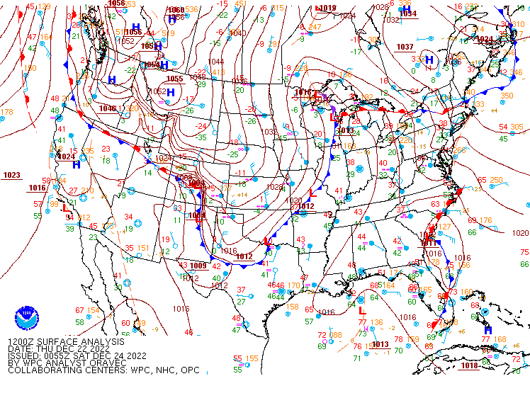 |
 |
 |
 |
| Figure 1: WPC surface analysis from Dec 22, 2022 7 AM through Dec 25, 2022 7 AM. | Figure 2: 300 mb analysis from Dec 22, 2022 7 AM through Dec 25, 2022 7 AM. | Figure 3: 500 mb analysis from Dec 22, 2022 7 AM through Dec 25, 2022 7 AM. | Figure 4: 850 mb analysis from Dec 22, 2022 7 AM through Dec 25, 2022 7 AM. |
 |
 |
.png) |
| Figure 5: 2-hour pressure change analysis (rises & falls) from Dec 22, 2022 7 PM through Dec 23, 2022 7 AM. | Figure 6: 3-hour temperature change analysis (increases in red, decreases in red) from Dec 22, 2022 7 PM through Dec 23, 2022 7 AM. | Temperature time series for KCLE, showing the dramatic drop in ambient temperatures Thursday night into Friday morning behind a strong cold front. Temperatures fell from as high as 43F around 1 AM to as low as -4F at noon. |
Water Levels
 |
 |
 |
| Toledo water level graph during the course of the event. Note that the observed water levels dropped as low as 7 to 8 feet below the low water datum. This broke the record for the lowest water measured at this site by 1.35 feet. The previously record was set on 30 January 2008. | Marblehead water level graph during the course of the event. Note that the observed water levels dropped as low as 3 to 4 feet below low water datum. | Buffalo water level graph during the course of the event. Note that the observed water levels rose to as high as 10 to 11 feet above low water datum, resulting in extensive coastal flooding along the shoreline of Lake Erie. |
 |
Media use of NWS Web News Stories is encouraged! Please acknowledge the NWS as the source of any news information accessed from this site. |
|

