June 16, 2019 Tornadoes
Overview
Three tornadoes occurred on June 16, 2019 through a 2-hour time period starting at ~1900 UTC (3 PM EDT), ending 2100 UTC (5 PM EDT). These tornadoes originated from the same parent storm, which tracked east-southeast over northeast Ohio through the afternoon. Two tornado warnings were issued during the event. At 1800 UTC (2 PM EDT), a stationary front was extended west to east across central Ohio as a weak upper level shortwave tracked east along Lake Erie. A storm initiated off the tail end of this shortwave and began to intensify just east of Cleveland as it interacted with a northward moving boundary from the stationary front. There was enough instability with MLCAPE greater than 500 J/kg and the interaction of this boundary allowed for the local shear to increase, leading to rotation towards the southern edge of the storm. Rotation continued to tighten until a brief, EF-1 tornado with maximum winds of 90 mph occurred around 3:23 PM EDT in Cuyahoga County near Glenwillow, lasting 5 minutes and tracking for 2 miles. A brief tornado debris signature (TDS) was observed in the correlation coefficient product before rotation weakened. As the storm continued east-southeast, it cycled and rotation tightened once again and produced an EF-1 tornado with maximum winds of 100 mph which began at 4:11 PM EDT in Portage County near Southington, and continued for 13.41 miles into Trumbull County before lifting near Warren at 4:34 PM EDT. Another larger, TDS signature was observed in the correlation coefficient product. Finally, as the storm continued east-southeast, it produced another EF-1 tornado at 4:44 PM EDT with maximum winds of 95 mph. The tornado tracked for about 6 miles through Trumbull County, starting east of Vienna, and lifting in West Hill at 4:51 PM EDT. Extensive tree and power line damage was surveyed across the damage paths, along with several damaged roofs to homes and businesses, and destroyed outbuildings.
Mesoanalysis
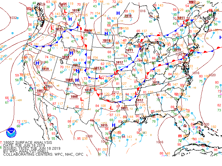
Weather Prediction Center (WPC) surface analysis at 18 UTC ( 2 PM EDT) on June 16, 2019
Storm Prediction Center (SPC) Day 1 Severe Weather Outlook for June 16, 2019, issued at 1630 UTC (12:30 PM)

Storm Prediction Center (SPC) severe weather storm reports for June 16, 2019, which includes the 3 tornadoes in northeast Ohio

All model images below are from the 12Z run of the HRRR for the 19Z hour (3 PM EDT)
Top left is simulated composite reflectivity. Top right is MUCAPE. Middle left is 0-1 km shear. Middle right is 0-6 km shear. Bottom left is 0-1 km SRH. Bottom right is 0-3 km SRH.


Radar
Radar Loop starting 1900 UTC (3 PM EDT) and ending 2100 UTC (5 PM EDT) on June 16, 2019.
Top left: Reflectivity; Top right: Base Velocity; Bottom left: NROT, or a way to measure rotation; Bottom right: Correlation Coefficient

Photos of Storm Damage


Tornado Information
Tornado 1 Public Information Statement (Cuyahoga)
000
NOUS41 KCLE 171433
PNSCLE
OHZ013-171845-

Public Information Statement
National Weather Service Cleveland OH
1033 AM EDT Mon Jun 17 2019

..NWS DAMAGE SURVEY FOR June 16, 2019 TORNADO EVENT...

.Cuyahoga County Tornado.

Start Location...1 WSW Glenwillow in Cuyahoga County OH
End Location...1 ESE Glenwillow in Cuyahoga County OH
Date...06/16/2019
Estimated Time...03:23 PM EDT
Maximum EF-Scale Rating...EF1
Estimated Maximum Wind Speed...90 mph
Maximum Path Width...150.0 yards
Path Length...2.04 miles
Beginning Lat/Lon...41.358 / -81.4967
Ending Lat/Lon...41.3539 / -81.4579
* Fatalities...0
* Injuries...0

...Summary...
A brief, weak tornado touched down just east of the intersection
of I-271 and I-480 near Oakwood at 3:23 PM EDT on June 16, 2019.
The tornado uprooted/snapped several trees in the area.  The
tornado traveled east for 2 miles before lifting near Glenwillow
at 3:28 PM EDT.

EF Scale: The Enhanced Fujita Scale classifies tornadoes into the
following categories:

EF0...Weak......65 to 85 mph
EF1...Weak......86 to 110 mph
EF2...Strong....111 to 135 mph
EF3...Strong....136 to 165 mph
EF4...Violent...166 to 200 mph
EF5...Violent...>200 mph

* The information in this statement is preliminary and subject to
change pending final review of the event and publication in NWS
Storm Data.

$$
Tornado 2 Public Information (Portage and Trumbull)
000
NOUS41 KCLE 171741
PNSCLE
OHZ013-172145-

Public Information Statement
National Weather Service Cleveland OH
141 PM EDT Mon Jun 17 2019


...NWS DAMAGE SURVEY FOR June 16, 2019 TORNADO EVENT...

.Trumbull County Tornado...

Start Location...3 N Windham in Portage County OH
End Location...1 WSW Howland Center in Trumbull County OH
Date...06/16/2019
Estimated Time...04:11 PM EDT
Maximum EF-Scale Rating...EF1
Estimated Maximum Wind Speed...100 mph
Maximum Path Width...250.0 yards
Path Length...13.41 miles
Beginning Lat/Lon...41.2823 / -81.0226
Ending Lat/Lon...41.2493 / -80.773
* Fatalities...0
* Injuries...0

...Summary...
A weak tornado touched down in far northeast Portage County
southwest of Southington.  The tornado briefly tracked northeast
before turning to the east-southeast. The tornado destroyed
several outbuildings and produced extensive tree damage,
epically about a mile south of Southington. The tornado had an
intermittent path across northern Warren before lifting near the
Trumbull Country Club.

EF Scale: The Enhanced Fujita Scale classifies tornadoes into the
following categories:

EF0...Weak......65 to 85 mph
EF1...Weak......86 to 110 mph
EF2...Strong....111 to 135 mph
EF3...Strong....136 to 165 mph
EF4...Violent...166 to 200 mph
EF5...Violent...>200 mph

* The information in this statement is preliminary and subject to
change pending final review of the event and publication in NWS
Storm Data.

$$
Tornado 3 Public Information Statement (Trumbull)
000
NOUS41 KCLE 171956
PNSCLE
OHZ013-180000-

Public Information Statement
National Weather Service Cleveland OH
356 PM EDT Mon Jun 17 2019


...NWS DAMAGE SURVEY FOR June 16, 2019 TORNADO EVENT...

. EasternTrumbull County Tornado...

Start Location...2 ESE Vienna in Trumbull County OH
End Location...West Hill in Trumbull County OH
Date...06/16/2019
Estimated Time...04:44 PM EDT
Maximum EF-Scale Rating...EF1
Estimated Maximum Wind Speed...95 mph
Maximum Path Width...250.0 yards
Path Length...5.97 miles
Beginning Lat/Lon...41.238 / -80.6365
Ending Lat/Lon...41.2278 / -80.5227
* Fatalities...0
* Injuries...0

...Summary...
NWS storm survey found damage indicative of an EF-1 tornado with
maximum winds of 95 mph and width of 250 yards.  The tornado
touched down east of Vienna and just north of St Rt 82, tracked
east across Brookfield, and lifted in West Hill.  The tornado
produced extensive tree damage across its path.

EF Scale: The Enhanced Fujita Scale classifies tornadoes into the
following categories:

EF0...Weak......65 to 85 mph
EF1...Weak......86 to 110 mph
EF2...Strong....111 to 135 mph
EF3...Strong....136 to 165 mph
EF4...Violent...166 to 200 mph
EF5...Violent...>200 mph

* The information in this statement is preliminary and subject to
change pending final review of the event and publication in NWS
Storm Data.

$$

