After a mild December 2011, northern Ohio and northwest Pennsylvania waited for winter. Even though precipitation was above normal in December 2011, most of it fell as rain. Most areas, even in the snowbelt, had recorded only a few inches of snow by the start of the new year. Several lake effect events did take place in January. The most notable lake effect storm occurred on January 13th-15th when the primary snowbelt received one to two feet of snow. Outside of the few lake effect snow storms, there were virtually no significant snow storms during the 2011-2012 winter. The snow that fell was light and melted within a few days since the cold snaps were short. Many locations ended the winter season (Dec-Feb) in the top ten of warmest winters on record.
Temperatures soared in March with over a week of consecutive days above 70 degrees. There were even days that topped 80. This put the month nearly 14 degrees above normal. The month shattered the previous monthly average temperature records by 2-3 degrees. There was one severe thunderstorm event that occurred during that warm stretch. On March 15th large-hail producing thunderstorms moved across northern Ohio. Some of the hail was as large golf balls.
The warm and dry spring of 2012 became the hot and dry summer of 2012. Temperatures in June and July were well above normal, with monthly temperatures in July averaging 4 to 5 degrees above normal. High temperatures reached 90 or above on dozens of days. The mercury topped 90 degrees 28 times at Cleveland and 32 times at Toledo. At Toledo, the temperature soared above 100 degrees 4 times! Other locations in northern Ohio and northwest Pennsylvania got close to 100 or exceeded 100 at least once or twice. There was little relief at night, with many nights seeing low temperatures barely dropping into the 70s, especially in July. The lack of rain compounded the summer stress. Rainfall was below normal in most areas from April through July. The combination of heat and drought left many farmers with parched soil. The drought in parts of northern Ohio was the worst since 1988, especially across parts of northwest Ohio. Rainfall in September and October was much above normal but was too little too late for many of the farmers.
The months of May through June were the busiest months for severe weather. Severe thunderstorms were reported on nine days during the month of May. The busiest days were May 7th and May 29th. On the 7th, a warm front lifted north across the region causing showers and thunderstorms to develop. A strong cold front moved across the region on the 29th. Strong winds and hail as large as golf balls were reported. A downburst caused extensive damage south of Youngstown in Mahoning County. A lot of large hail was reported across Erie and Crawford Counties of Northwest Pennsylvania. Many vehicles and some buildings were damaged.


The most memorable event of the summer was the Derecho that took place on June 29th. An intense line of thunderstorms or Derecho developed over northern Indiana during the middle of the afternoon and then raced southeast across the central portion of Ohio. Widespread damage was reported from Findlay to Marion to Mount Vernon. Further south, central Ohio including the Columbus area was devastated . As many as one million people lost power during this event. An 84 mph wind gust was measured in Findlay. It took nearly a week for power to be fully restored. After exiting Ohio, the Derecho continued to the Mid-Atlantic states killing 22 people and causing billions of dollars in damage. Only three other days during the month of June had severe weather and these occurred during the second half of the month.

July picked back up again with severe weather reported on nine days. Hail as large as baseballs fell on the 1st. A downburst moved off of Lake Erie and across Catawba Island in Ottawa County to near Norwalk in Huron County. Significant tree and house damage was reported. More damaging hail and winds were reported on the July 4th holiday. Evening fireworks shows were rained out in many areas. The warm and humid airmass in place over region led to vivid and memorable lightning displays during the evening hours.
The severe season began to wind down, as it usually does for the months of August and September. A few thunderstorms occurred during the month of August along with the only tornado of the season. The tornado occurred near Girard in southern Trumbull County on the 5th. The tornado was classified as an EF0 and had an intermittent damage path of around four miles. There was minor damage to a few homes and vehicles.
Waterspouts were observed on Lake Erie on a few occasions during the months of August and September. With very warm lake temperatures and a few "cool" spells the set-up was there for waterspouts. These months were the first in a while where we were near or slightly below normal. Typically the best time for waterspouts is September into October as we begin to have winter-like rounds of cold air moving over Lake Erie.


photos courtesy of USCG
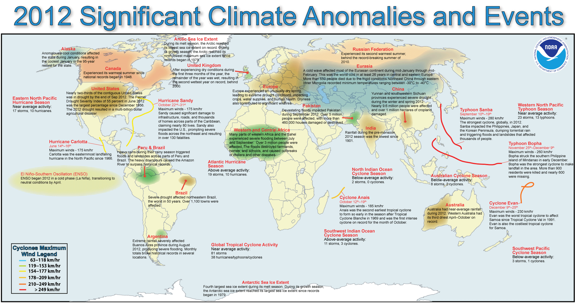
While all eyes were on the east coast as the remnants of Hurricane Sandy were impacting New York, New Jersey, and Pennsylvania on October 29th-31st, locally this storm impacted the south shore of Lake Erie. Considerable damage was reported just inland of the lake from Toledo to near Erie, Pennsylvania. The damage was most concentrated in the Cleveland area where over a quarter million people lost power for up to a week. Interstate 90 on the city’s east side had to be closed because of waves up to 19 feet crashing on the road surface. Over 100 boats were sunk or destroyed by the pounding waves. Tree damage was significant. Peak wind gusts of just under 70 mph were reported. Some sources had damage estimates from the storm approaching 100 million dollars. Rainfall from the remnants interacted with a frontal boundary that was stalled across the area. The rainfall led to flooding along area rivers. The Cuyahoga River reached into major flood status. The Huron, Vermilion, Chagrin, and Black Rivers reached into minor and moderate flood status. Along the Cuyahoga River the worst flooding occurred in the Valley View area where many roads were blocked and basements inundated. With the winds forcing large waves on Lake Erie and a rise in water level along the southern shore, rivers were not draining as efficiently. The combination of lake-induced flooding and river flooding from rainfall resulted in flooding in the towns of Willoughby and Vermilion, where homes near the mouth of the rivers were inundated.
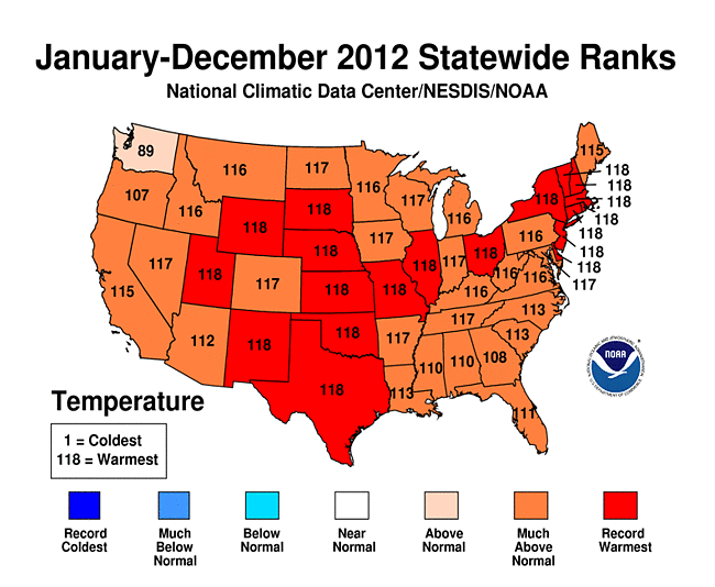
2012 was the warmest year on record for Cleveland and Akron, OH. Also, Mansfield tied for the 2nd warmest year on record, Erie, PA had the 2nd warmest, Toledo had its 4th warmest, and Youngstown had its 6th warmest.
| Cleveland | ||||||||||||||
|---|---|---|---|---|---|---|---|---|---|---|---|---|---|---|
| # | Year | Jan | Feb | Mar | Apr | May | Jun | Jul | Aug | Sep | Oct | Nov | Dec | Annual |
| 1 | 2012 | 32.5 | 34.9 | 51.4 | 48.8 | 65 | 71.4 | 78 | 72.2 | 62.8 | 53 | 40.3 | 37.8 | 54 |
|
Departure from Normal |
4.4 | 4.4 | 13.0 | -1.0 | 5.2 | 2.2 | 4.5 | 0.2 | -2.2 | -0.8 | -3.6 | 5.4 | 4.0 | |
Cleveland was 4.0ºF above normal for the year and a half degree warmer than the previously warmest year (1998).
| Akron | ||||||||||||||
|---|---|---|---|---|---|---|---|---|---|---|---|---|---|---|
| # | Year | Jan | Feb | Mar | Apr | May | Jun | Jul | Aug | Sep | Oct | Nov | Dec | Annual |
| 1 | 2012 | 31.6 | 33.8 | 51.1 | 49.2 | 66.5 | 70.6 | 77.5 | 71.4 | 62.8 | 52.5 | 39.5 | 37.3 | 53.7 |
|
Departure from Normal |
5.5 | 4.8 | 13.5 | 0.0 | 7.6 | 2.7 | 5.5 | 0.9 | -0.3 | 0.8 | -2.0 | 6.9 | 3.8 | |
Akron was 3.8ºF above normal for the year and one-tenth of a degree warmer than the previously warmest year (1887).
The state of Ohio as a whole ended up with the warmest year on record. For Pennsylvania, 2012 landed in 3rd place. The entire country had temperatures that were above normal. In 2012, the contiguous United States (CONUS) average annual temperature of 55.3°F was 3.2°F above the 20th century average, and was the warmest year in the 1895-2012 period of record for the nation. The 2012 annual temperature was 1.0°F warmer than the previous record warm year of 1998.
Here's a summary of the records set in 2012:
|
|
||||||||||||||||||||||||||||||||||||||||||||||||||||||||||||||||||||||||||||||||||||||||||||||||||||||||||||||||||||||||||||||||||||||||||||||||||||||||||||||||||||||||||||||||||||||||||||||||||||||||||||||||||||||||||||||||||||||||||||||||||||||||||||||||||||||||||||||||||||||||||||||||
|
|
||||||||||||||||||||||||||||||||||||||||||||||||||||||||||||||||||||||||||||||||||||||||||||||||||||||||||||||||||||||||||||||||||||||||||||||||||||||||||||||||||||||||||||||||||||||||||||||||||||||||||||||||||||||||||||||||||||||||||||||||||||||||||||||||||||||||||||||||||||||||||||||||
|
|
||||||||||||||||||||||||||||||||||||||||||||||||||||||||||||||||||||||||||||||||||||||||||||||||||||||||||||||||||||||||||||||||||||||||||||||||||||||||||||||||||||||||||||||||||||||||||||||||||||||||||||||||||||||||||||||||||||||||||||||||||||||||||||||||||||||||||||||||||||||||||||||||

A text description of the 2011-2012 Season Snowfall can be found here. Seasonal snowfall totals that contributed to this map can be found here.
A number of monthly temperature and precipitation records occurred across our climate sites this year.
All of these monthly statistics for our climate stations can be found year round by going to the following link and selecting your station. Data each month are updated within a week if data for the previous month made the "top ten."
NWS Cleveland Unique Local Climate Data
Records that encompass yearly totals such as the wettest/driest/snowiest years on record are again located on our Unique Local Climate Data page.
View our growing local weather events page highlighted below.
Local Weather Events & Local Interest Features Page
The publication, StormData, can be found with the National Climate Data Center.
Significant Global Climate Extremes and Anomalies 2012
NCDC 2012 Preliminary Annual Global Climate Report
NCDC 2012 Preliminary United States Significant Weather and Climate Events
NCDC 2012 Preliminary State of the Climate - U.S. Summary
Preliminary data is updated in mid-January to reflect end of the year weather. The full analysis will be out in spring.
All data are considered preliminary. The National Climate Data Center finalizes and stores the official record of all of our weather data.
Period of record are as follows:
Records data back to 1873 for Erie
1897 for Youngstown
1887 for Canton-Akron
1871 for Cleveland
1873 for Toledo
1916 for Mansfield

