
A strengthening storm system over the Upper Great Lakes will bring moderate to heavy snow to the Upper Peninsula of Michigan through Tuesday morning. Ahead of this system, strong to severe storms may develop over the Ohio Valley, portions of the Appalachians, and the Mid Atlantic Monday. Read More >
NOAA Weather Radio is a service of the National Oceanic and Atmospheric Administration (NOAA) of the U.S. Department of Commerce. NOAA Weather Radio is a nationwide network of government-operated radio stations designed to provide the public with a constant source of up-to-date weather information. It provides continuous broadcasts of the latest weather information from local National Weather Service offices. Weather messages are repeated every 4 to 6 minutes, and are routinely updated every 1 to 3 hours or more frequently in rapidly changing local weather. The service operates 24 hours daily. The regular broadcasts are specifically tailored to weather information needs of the people within the service area of the transmitter. For example, in addition to general weather information, stations in coastal areas provide information of interest to mariners.
Each station broadcasts local weather forecasts from a nearby National Weather Service office and, when necessary, sends out alerts to warn the public of potentially life-threatening conditions. Most new NOAA Weather Radios are equipped with a tone alarm, or a special alerting feature (known as S.A.M.E.) which can be programmed to let you know immediately when the National Weather Service issues a warning for your specific area. When a warning is issued coded information is broadcast interrupting routine broadcasting. These codes activate tone- and SAME-alert radios in the affected areas. By receiving these warnings immediately, the public can seek safety and protect themselves and those around them. New codes allow NOAA Weather Radio to be used to alert the public to other hazards or emergency situations such as oil spills or chemical releases. This will eventually allow NOAA Weather Radio to be a source for both weather and non-weather emergency alerts.
Under a January 1975 White House policy statement, NOAA Weather Radio was designated the sole government-operated radio system to provide direct warnings into private homes for both natural disasters and nuclear attack. This concept is being expanded to include warnings for all hazardous conditions that pose a threat to life and safety, both at a local and national level.
NOAA Weather Radio currently broadcasts from over 800 FM transmitters on seven frequencies in the VHF band, ranging from 162.400 to 162.550 megahertz (MHz) in fifty states, Puerto Rico, the Virgin Islands, Guam, and Saipan. These frequencies are outside the normal AM or FM broadcast bands.
Special radios that receive only NOAA Weather Radio, both with and without the tone alert feature, are available from several manufacturers. The radios can usually be found at most department and electronics stores and online at electronics web merchants. In addition, other manufacturers are including NOAA Weather Radio as a special feature on an increasing number of receivers: NOAA Weather Radio capability is currently available on some automobile, aircraft, marine, citizens band, and standard AM/FM radios, as well as communications receivers, transceivers, scanners, and cable TV. See NOAA Weather Radio Receiver Information if you are thinking of buying one. The page contains a list of manufacturers and recall info on a few radios.
By nature and by design, NOAA Weather Radio coverage is typically limited to an area within 40 miles of the transmitter. The quality of what is heard is dictated by the distance from the transmitter, local terrain, and the quality and location of the receiver. In general, those on flat terrain or at sea, using a high quality receiver, can expect reliable reception far beyond 40 miles. Those living in cities surrounded by large buildings, and those in mountain valleys, with standard receivers may experience little or no reception at considerably less than 40 miles. If possible, a receiver should be tested in the location where it will be used prior to purchase.
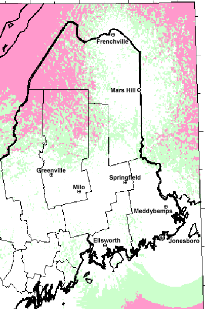
The Caribou Weather Forecast Office operates 8 NOAA Weather Radio transmitters across northern and Downeast Maine. Here's a list:
| Location | Frequency | Call Sign | Power |
|---|---|---|---|
| Ellsworth, Hancock Co. | 162.400 MHz | KEC-93 | 1000 watts |
| Frenchville, Aroostook Co. | 162.475 MHz | KHB-55 | 300 watts |
| Greenville, Piscataquis Co. | 162.425 MHz | WNG-542 | 300 watts |
| Jonesboro, Washington Co. (marine specific) |
162.450 MHz | WNG-543 |
1000 watts |
| Mars Hill, Aroostook Co. | 162.525 MHz | WXM-77 | 100 watts |
| Meddybemps, Washington Co. | 162.425 MHz | WHC-47 | 300 watts |
| Milo, Piscataquis Co. | 162.550 MHz | KHB-54 | 1000 watts |
| Springfield, Penobscot Co. | 162.500 MHz | WXN-28 | 1000 watts |
Jonesboro's primary programming is dedicated to marine forecasts, observations, and warnings for the intended use of both commercial and recreational mariners. In addition, severe weather warnings for Washington and Hancock counties will be aired on this station.
The newer NOAA Weather Radio receivers require that you input special codes so the receiver will sound an alarm when it receives a severe weather SAME alert for a specific county. The SAME codes are the Federal Information Processing Standards (FIPS) codes for each county with a zero prefixed. Here is a list of these codes for each of the counties for which the Caribou office forecasts.
| County | SAME Code |
|---|---|
| Aroostook | 023003 |
| Hancock | 023009 |
| Penobscot | 023019 |
| Piscataquis | 023021 |
| Somerset | 023025 |
| Washington | 023029 |
Here is a map showing NOAA Weather Radio coverage in our area. Find your location then check the color.
More information can be found at the National Weather Service NOAA Weather Radio page. Specifically, good info can be found about our weekly NOAA Weather Radio Alarm Tests.


 Coastal Flood