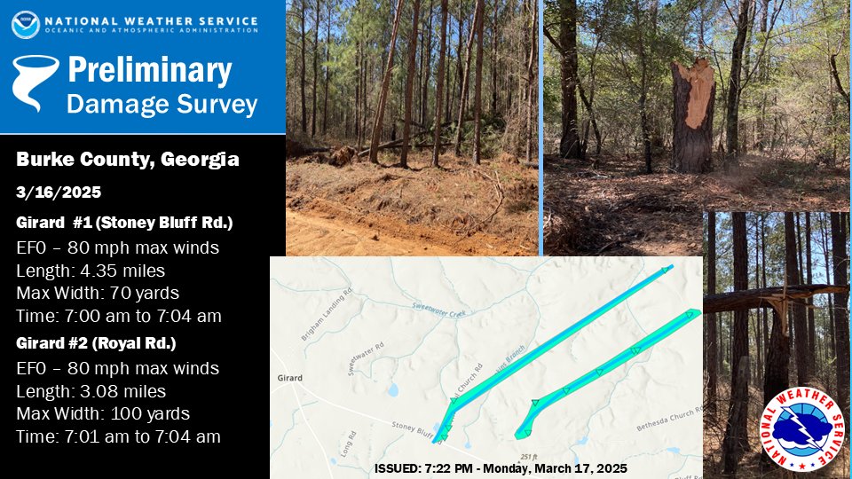
...NWS Damage Survey for 03/16/25 Tornado Event...

...Girard, GA EF-0 Tornado in Burke County (Stoney Bluff Road)...

Rating:                 EF0
Estimated Peak Wind:    80 mph
Path Length /statute/:  4.35 miles
Path Width /maximum/:   75 yards
Fatalities:             0
Injuries:               0

Start Date:             03/16/2025
Start Time:             07:00 AM EDT
Start Location:         2 ESE Girard / Burke County / GA
Start Lat/Lon:          33.0275 / -81.6767

End Date:               03/16/2025
End Time:               07:04 AM EDT
End Location:           5 WSW Millett / Burke County / GA
End Lat/Lon:            33.0646 / -81.617

Survey Summary:
A National Weather Service storm survey determined that one of
two close proximity EF-0 tornadoes touched down east of Girard,
GA with peak wind speeds of 80 mph.

The northernmost tornado began near the intersection of Stoney
Bluff Road and Thankful Church Road where it snapped several pine
trees. The tornado then continued northeast into an inaccessible
heavily wooded area, before snapping additional pine trees along
River Road. Given a lack of access, this tornado is assumed to
have dissipated just prior to reaching the Savannah River.
...Girard, GA EF-0 Tornado in Burke County (Royal Road)...

Rating:                 EF0
Estimated Peak Wind:    80 mph
Path Length /statute/:  3.08 miles
Path Width /maximum/:   100 yards
Fatalities:             0
Injuries:               0

Start Date:             03/16/2025
Start Time:             07:01 AM EDT
Start Location:         3 E Girard / Burke County / GA
Start Lat/Lon:          33.0295 / -81.6556

End Date:               03/16/2025
End Time:               07:04 AM EDT
End Location:           5 WSW Millett / Burke County / GA
End Lat/Lon:            33.0546 / -81.6121

Survey Summary:
A National Weather Service storm survey determined that one of
two close proximity EF-0 tornadoes touched down east of Girard,
GA with peak wind speeds of 80 mph.

The southernmost of these two tornadoes began along Royal Road
just north of Stoney Bluff Road causing minor tree damage. Moving
northeast, the tornado caused shingle damage to a residence
followed by additional tree damage along Royal Road. Given a lack
of access, this tornado is assumed to have dissipated just prior
to reaching the Savannah River.
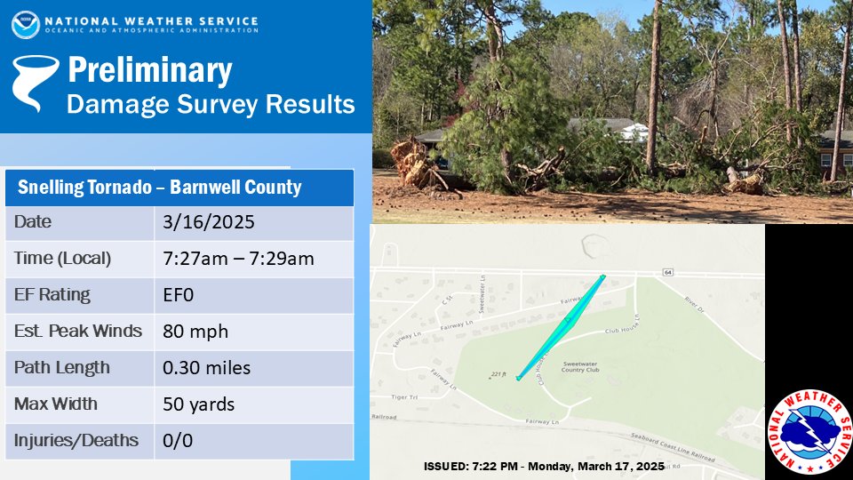
...Snelling, SC EF-0 Tornado in Barnwell County...

Rating:                 EF0
Estimated Peak Wind:    80 mph
Path Length /statute/:  0.30 miles
Path Width /maximum/:   50 yards
Fatalities:             0
Injuries:               0

Start Date:             03/16/2025
Start Time:             07:27 AM EDT
Start Location:         2 E Snelling / Barnwell County / SC
Start Lat/Lon:          33.2371 / -81.4194

End Date:               03/16/2025
End Time:               07:29 AM EDT
End Location:           2 E Snelling / Barnwell County / SC
End Lat/Lon:            33.2407 / -81.4164

Survey Summary:
A National Weather Service storm survey determined that an EF-
0 tornado touched down between Snelling and Barnwell, SC with
peak winds of 80 mph.

The short-lived tornado began in the Sweetwater Country Club,
between Fairway Lane and Club House Lane, and moved to the
northeast. The tornado uprooted at least 5 large pine trees and
snapped several large branches before dissipating around Dunbarton
Blvd.
...Chapin-Lake Murray, SC EF-1 Tornado in Lexington County...

Rating:                 EF1
Estimated Peak Wind:    90 mph
Path Length /statute/:  5.83 miles
Path Width /maximum/:   125 yards
Fatalities:             0
Injuries:               0

Start Date:             03/16/2025
Start Time:             07:38 AM EDT
Start Location:         6 S Chapin / Lexington County / SC
Start Lat/Lon:          34.0751 / -81.3858

End Date:               03/16/2025
End Time:               07:48 AM EDT
End Location:           2 W Lake Murray Of Richland / Lexington County / SC
End Lat/Lon:            34.1274 / -81.308

Survey Summary:
A National Weather Service storm survey team determined that a
tornado formed over Lake Murray near Dreher Island before causing
high end EF-0 to low end EF-1 tree damage near Lake Estate Dr in Chapin.
The tornado then continued northeast causing EF-0 and low end EF-1
tree damage over the Timberlake community. The tornado then moved
toward Isle of Pines Rd where the most concentrated EF-1 damage
was found before re-entering the lake, turning more east northeast.
It caused more EF0 tree damage from Indian Cove Rd to Wessinger Rd,
dissipating before reaching Indian Fork Rd.