Overview
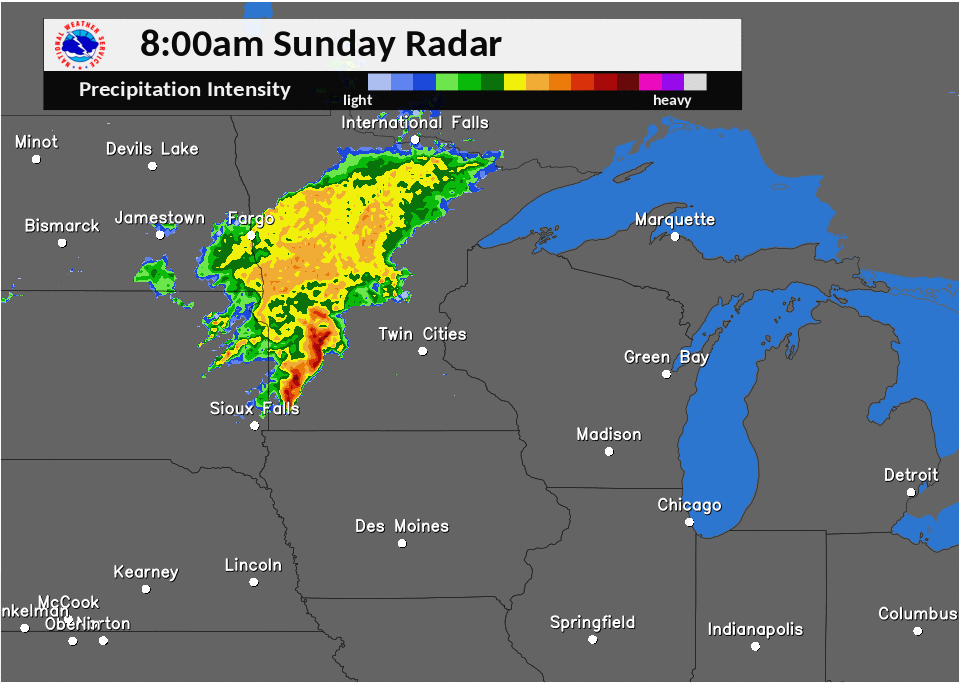
A line of severe thunderstorms impacted northern Michigan during the afternoon of Sunday, June 11th, 2017. Interesting to note, the line of thunderstorms originally developed during the morning hours of June 11th across eastern South Dakota before racing eastward through southern Minnesota, central and northern Wisconsin before crossing the Tip of the Mitt and eastern Upper Michigan.
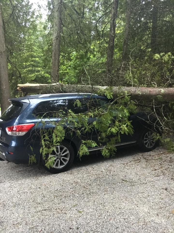
The first severe thunderstorm warning was issued at 3:39 pm with an additional four warnings issued before the last warning expired at 5:48 pm. Wind gusts in excess of 60 mph caused damage to trees, power lines, and outbuildings.
The following loop is Doppler Radar imagery of the event unfolding from 8 am over southwest Minnesota until its arrival in Michigan during the mid-late afternoon hours.
Wind:
The following is a preliminary storm reports map, along with wind damage pictures from Sunday June 11th, 2017. Widespread trees and power lines down were reported across portions of the Tip of the Mitt and eastern Upper Michigan. For more information regarding specific storm reports, click the Storm Reports tab above.

Wind Damage Images
|
|
 |
|
|
| Alvero Fire Hall Courtesy of Adam Price |
9 miles east of Cedarville Courtesy of Karyll Groty Russell |
Black Lake Courtesy of Harry Hopkins |
Mackinac Bridge Courtesy of Mack. Bridge Authority |
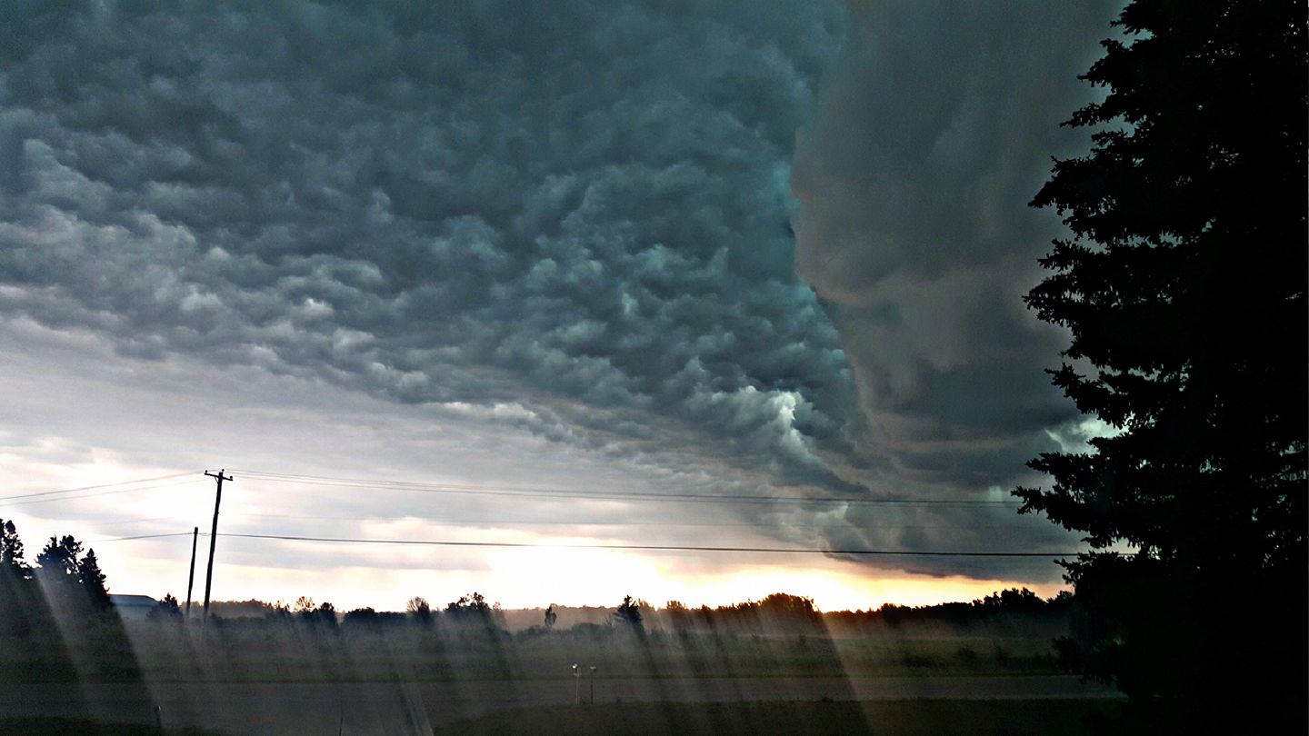
Additional Photos:
The following are a collection of images from Sunday, June 11, 2017 from the Tip of the Mitt and eastern Upper Michigan.
 |
 |
 |
 |
| Shelf cloud over the Mackinac Bridge Courtesy of Paola Catallo-Lieghio |
Shelf cloud over the Mackinac Bridge Courtesy of Lisa Pallagi |
Shelf cloud over Mackinac Island Courtesy of Sarah Prince |
Shelf cloud over The Straits Courtesy of Serena Lake |
 |
 |
 |
 |
| Mackinac Bridge Courtesy of Mack. Bridge Authority |
East of Cedarville, MI Courtesy of Mack Co. Emg Mgmt |
Shelf cloud over Benton Township, MI Courtesy of Kim Ruley |
Cheboygan, MI Courtesy of Megan Price |
Radar:
Gaylord, MI Doppler Radar imagery from 3:30 pm - 5:30 pm June 11, 2017.
Storm Reports

PRELIMINARY LOCAL STORM REPORT...SUMMARY
NATIONAL WEATHER SERVICE GAYLORD MI

..TIME...   ...EVENT...      ...CITY LOCATION...     ...LAT.LON...
..DATE...   ....MAG....      ..COUNTY LOCATION..ST.. ...SOURCE....
            ..REMARKS..

0354 PM     MARINE TSTM WIND 11 SW CORINNE           45.96N 85.86W
06/11/2017  M41 MPH          LMZ341             MI   OTHER FEDERAL

            FROM STATION PNLM4.

0405 PM     TSTM WND DMG     BEAVER ISLAND           45.70N 85.55W
06/11/2017                   CHARLEVOIX         MI   PUBLIC

            A COUPLE TREES DOWN. TIME ESTIMATED.

0431 PM     TSTM WND DMG     3 N MACKINAW CITY       45.82N 84.73W
06/11/2017                   LHZ345             MI   EMERGENCY MNGR

            CAMPER FLIPPED OVER ON MACKINAC BRIDGE. TIME
            ESTIMATED.

0431 PM     TSTM WND GST     1 SW CHARLEVOIX         45.30N 85.27W
06/11/2017  M44 MPH          CHARLEVOIX         MI   AWOS

            AWOS STATION CVX, CHARLEVOIX.

0435 PM     NON-TSTM WND GST 1 WSW IRONTON           45.26N 85.22W
06/11/2017  M46 MPH          CHARLEVOIX         MI   MESONET

            MESONET STATION D7501, IRONTON.

0436 PM     TSTM WND GST     MACKINAW CITY           45.78N 84.73W
06/11/2017  M45 MPH          CHEBOYGAN          MI   BUOY

            BUOY STATION MACM4, MACKINAW CITY.

0436 PM     NON-TSTM WND GST MACKINAW CITY           45.78N 84.73W
06/11/2017  M45 MPH          CHEBOYGAN          MI   BUOY

            BUOY STATION MACM4, MACKINAW CITY.

0438 PM     TSTM WND GST     MACKINAC ISLAND         45.86N 84.64W
06/11/2017  M60 MPH          MACKINAC           MI   AWOS

            MEASURED AT KMCD.

0439 PM     TSTM WND GST     1 NW PELLSTON           45.57N 84.80W
06/11/2017  M54 MPH          EMMET              MI   ASOS

            ASOS STATION PLN, PELLSTON RGNL AIRPORT OF
            EMMET COUNTY.

0442 PM     TSTM WND DMG     4 E PELLSTON            45.55N 84.71W
06/11/2017                   CHEBOYGAN          MI   TRAINED SPOTTER

            REPORT OF TREES DOWN. TIME ESTIMATED FROM
            RADAR.

0442 PM     TSTM WND DMG     3 WNW BOYNE CITY        45.21N 85.02W
06/11/2017                   CHARLEVOIX         MI   PUBLIC

            LARGE TREE LIMB DOWN AT WEST ST AND PLEASANT
            AVE. TIME ESTIMATED.

0444 PM     TSTM WND DMG     2 W BRUTUS              45.50N 84.79W
06/11/2017                   EMMET              MI   LAW ENFORCEMENT

            TREES REPORTED DOWN IN MAPLE RIVER TWP.
            REPORT RELAYED FROM LAW ENFORCEMENT.

0447 PM     TSTM WND DMG     2 N HARBOR SPRINGS      45.46N 84.99W
06/11/2017                   EMMET              MI   LAW ENFORCEMENT

            POWER TRANSFORMER ON FIRE. RELAYED FROM LAW
            ENFORCEMENT.

0448 PM     TSTM WND DMG     STUTSMANVILLE           45.50N 85.03W
06/11/2017                   EMMET              MI   LAW ENFORCEMENT

            TREES REPORTED DOWN OVER POWER LINES.
            RELAYED FROM LAW ENFORCEMENT.

0448 PM     TSTM WND DMG     4 SSE ODEN              45.38N 84.80W
06/11/2017                   EMMET              MI   LAW ENFORCEMENT

            TREES ON POWER LINES NEAR THE INTERSECTION
            OF PICKEREL LAKE RD AND SILVER CREEK RD.
            RELAYED BY LAW ENFORCEMENT.

0449 PM     TSTM WND DMG     4 NE BRUTUS             45.53N 84.70W
06/11/2017                   CHEBOYGAN          MI   LAW ENFORCEMENT

            POWER LINES DOWN. RELAYED VIA LAW
            ENFORCEMENT.

0449 PM     TSTM WND DMG     5 N MCCARRON            46.40N 84.27W
06/11/2017                   CHIPPEWA           MI   PUBLIC

            PUBLIC REPORT OF TREES DOWN ACROSS ROAD.
            TIME ESTIMATED.

0455 PM     TSTM WND DMG     2 SSE ALOHA             45.50N 84.45W
06/11/2017                   CHEBOYGAN          MI   FIRE DEPT/RESCUE

            PICTURE RELAYED VIA SOCIAL MEDIA OF ROOF
            DAMAGE AT ALOHA TOWNSHIP FIRE HALL. TIME
            ESTIMATED.

0457 PM     TSTM WND DMG     7 SSW GOETZVILLE        45.99N 84.17W
06/11/2017                   CHIPPEWA           MI   PUBLIC

            LARGE TREE DOWN ON VEHICLE. TIME ESTIMATED.

0458 PM     TSTM WND DMG     5 S MUNUSCONG           46.17N 84.18W
06/11/2017                   CHIPPEWA           MI   PUBLIC

            TREES UPROOTED, CAMPER MOVED, AND SOME
            DAMAGE TO SHINGLES ON S MAPLE POINT RD IN
            PICKFORD. TIME ESTIMATED.

0502 PM     TSTM WND DMG     1 E BLACK LAKE          45.49N 84.26W
06/11/2017                   CHEBOYGAN          MI   LAW ENFORCEMENT

            TREES DOWN AT BLACK LAKE CAMPGROUND. RELAYED
            VIA LAW ENFORCEMENT.

0503 PM     TSTM WND DMG     BLACK LAKE              45.49N 84.28W
06/11/2017                   CHEBOYGAN          MI   PUBLIC

            A COUPLE LARGE TREES DOWN, INCLUDING ONE ON
            A VEHICLE. TIME ESTIMATED.

0503 PM     TSTM WND DMG     RABER                   46.11N 84.09W
06/11/2017                   CHIPPEWA           MI   PUBLIC

            OVER 25 TREES REPORTED DOWN IN RABER. TIME
            ESTIMATED.

0508 PM     TSTM WND DMG     ONAWAY                  45.36N 84.23W
06/11/2017                   PRESQUE ISLE       MI   PUBLIC

            TREE DOWN ACROSS POWER LINES. TIME
            ESTIMATED.

0520 PM     TSTM WND DMG     1 S MILLERSBURG         45.31N 84.06W
06/11/2017                   PRESQUE ISLE       MI   PUBLIC

            PUBLIC REPORT OF TREE ACROSS THE ROAD. TIME
            ESTIMATED.

0535 PM     MARINE TSTM WIND 1 SSW ROGERS CITY       45.41N 83.81W
06/11/2017  M38 MPH          PRESQUE ISLE       MI   AWOS

            AWOS STATION PZQ, ROGERS CITY.

0545 PM     SEICHE           3 NNW PRESQUE ISLE      45.34N 83.50W
06/11/2017                   LHZ347             MI   BROADCAST MEDIA

            DELAYED REPORT. TIME ESTIMATED. REPORT OF
            DEBRIS ON THE BEACH AND WATERLINE ROUGHLY 5
            TO 6 FEET ABOVE NORMAL AT TIMES MOVING
            PIECES OF FURNITURE INLAND.
 |
Media use of NWS Web News Stories is encouraged! Please acknowledge the NWS as the source of any news information accessed from this site. |
|


 Follow us on YouTube