Overview
Heavy rainfall impacted northern Michigan for an approximately 72 hours period beginning on the afternoon of October 22 and ending the morning of October 25. A number of locations in northern Lower Michigan picked up more than 4 inches of rain over the 3 day period...resulting in flooding of some creeks and rivers.
Flooding
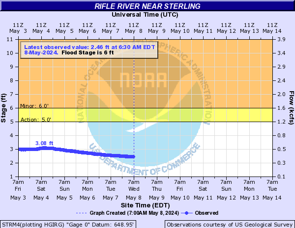
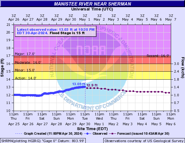
Several river gauge locations exceeded flood stage during this event...including the Manistee River near Sherman (crested at 15.48 feet/Flood stage 15 feet) and the Rifle River near Sterling (crested at 7.70 feet/Flood stage 6 feet). The Thunder Bay River near Bolton in Alpena County also set a new record stage during this event (crested 18.15 feet/Old record 17.70 feet).
Hydrographs
 |
 |
 |
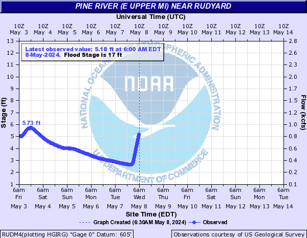 |
| River stage hydrograph: Rifle River near Sterling (Arenac Co) | River stage hydrograph: Manistee River near Sherman (Wexford Co) | River stage hydrograph: Thunder Bay River near Bolton (Alpena Co) | River stage hydrograph: Pine River near Rudyard (Chippewa Co) |
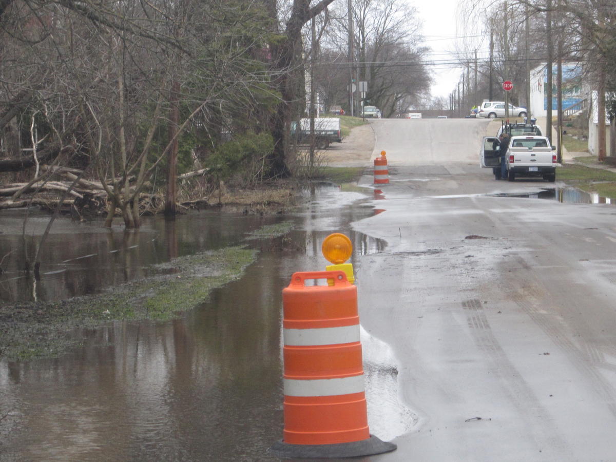
Radar/Photos
| Here is an overview of the rainfall for the seven day period ending Oct 26. Areas of orange indicate more than 4 inches of rainfall...while the red areas indicate more than 5 inches of rain. |
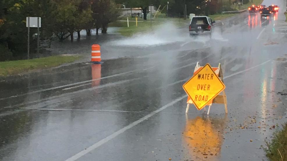
Photos & Video:
Header
 |
 |
 |
| Flooding in Traverse City (UpNorthLive) |
Kid's Creek Overflowing onto Cedar Street in Traverse City (Peter Payette) |
Flooding along North Branch of the Lincoln River (Mason County) |
Rain Reports
...72 hour rainfall totals from 8am Oct 22 until 8am Oct 25...

Location                     Amount     Provider
Meauwataka                   7.00 in
Mancelona                    6.22 in    COCORAHS
2 NE Luzerne                 5.84 in    COCORAHS
Traverse City Munson         5.54 in    COOP
Tippy Dam                    5.25 in    COOP
Mio                          5.21 in    RAWS
Nw Michigan Res Farm         5.16 in    COOP
2 NNW East Jordan            5.15 in    COCORAHS
2 NNW East Jordan            5.14 in    COOP
1 NNW Fife Lake              5.09 in    COOP
Charlevoix                   5.05 in    COOP
1 ENE Wellston               5.00 in    RAWS
2 SE Roscommon               4.99 in    RAWS
Harbor Springs               4.93 in    COCORAHS
4 NW Honor                   4.90 in
3 S Suttons Bay              4.90 in
2 ENE Kingsley               4.83 in    COCORAHS
Petoskey Ncmc                4.82 in    COOP
4 WSW Bates                  4.82 in    COCORAHS
Roscommon County Airport     4.80 in    ASOS
Houghton Lake                4.77 in    COCORAHS
2 W Ellsworth                4.70 in    COCORAHS
2 SSW Hartwick Pines State P 4.64 in    RAWS
1 S Lupton                   4.61 in    COOP
Alger                        4.58 in    RAWS
2 S Indian River             4.51 in    RAWS
Cadillac                     4.50 in    COOP
Petoskey                     4.48 in    CWOP
2 SW Stutsmanville           4.46 in    COCORAHS
1 WNW Waters                 4.45 in    GOES
9 SSW Gaylord                4.43 in    COOP
Glennie 2se                  4.38 in    COOP
Ironton                      4.37 in    COCORAHS
Lovells                      4.35 in    COCORAHS
Exp Farm                     4.35 in    COOP
Beulah 7ssw                  4.32 in    COOP
Clear Lake State Park        4.32 in    RAWS
5 W Waters                   4.29 in    COCORAHS
1 NNE Clarion                4.22 in    CWOP
Cherry Capital Airport       4.20 in    ASOS
1 W Gaylord                  4.20 in    COCORAHS
Gaylord                      4.20 in    COOP
2 W Lewiston                 4.15 in    CWOP
Gladwin                      4.14 in    COOP
Manistee County-blacker Airp 4.08 in    AWOS
1 SE Barton City             4.08 in    RAWS
Rogers City                  4.02 in    COCORAHS
2 SSE Gaylord                4.00 in    CWOP
Saint Ignace                 3.81 in    COCORAHS
Mancelona                    3.81 in    CWOP
1 WSW Gaylord                3.65 in    NONFEDAWOS
Otsego County Airport        3.65 in    ASOS
Rogers City                  3.65 in    CWOP
Detour Village               3.64 in    COOP
1 SSW Grawn                  3.55 in    CWOP
Sault Ste Marie              3.53 in    ASOS
Phelps Collins Field         3.52 in    ASOS
Sault Ste Marie              3.51 in    COOP
Pellston Rgnl Airport Of Emm 3.51 in    ASOS
1 WNW Waters                 3.28 in    CWOP
4 SSE Standish               3.27 in    COOP
4 W Raco                     3.26 in    RAWS
Moran                        3.26 in    COOP
4 NNE National City          3.22 in    COCORAHS
Cheboygan                    3.09 in    COOP
Kincheloe                    3.08 in    RAWS
4 S Sid Town                 3.05 in    RAWS
12 WNW Leland                3.02 in    RAWS
1 E Trout Lake               2.99 in    RAWS
Ironton                      2.99 in    CWOP
Mackinac Island              2.85 in    AWOS
2 E Oden                     2.81 in    CWOP
Hale 5ssw                    2.70 in    COOP
6 E Cheboygan                2.59 in    CWOP
1 WNW Rexton                 2.40 in    RAWS
East Tawas                   2.05 in    CWOP
3 WSW Onekama                2.01 in    CWOP
East Tawas                   1.99 in    COOP
 |
Media use of NWS Web News Stories is encouraged! Please acknowledge the NWS as the source of any news information accessed from this site. |
|


 Follow us on YouTube