Overview
|
A 1010mb surface low slowly tracked over the Great Lakes Thursday night into early Friday October 23rd morning. Abnormally high amounts of atmospheric moisture combined with lift from the low pressure system created a prolonged stretch of moderate to heavy rain from late Thursday afternoon through Friday. The swath of heaviest rain totaling 3.5 to 5 inches fell from near Grand Traverse Bay over to Gaylord. COOP weather stations in both Traverse City and Gaylord received their second highest 24-hour rain totals, of 3.75” and 4.49” respectively. There was a large gradient in rainfall totals across the area, with some areas near Saginaw Bay receiving less than a tenth of an inch through Friday morning. Many area rivers saw significant rises from this event, with some approaching or breaking long-time records. Once the low pressure system moved off to the east a tightened pressure gradient resulted in northwest winds gusting to 40 mph, leading to minor lakeshore flooding on shores of northwest Lower Michigan. Much colder air rapidly moved in behind the cold front with some lake effect rain/snow showers lingering through Friday night. |
 Radar Loop 2:00 PM Oct 22nd - 8:00 AM Oct 23rd, 2020 |
Flooding:
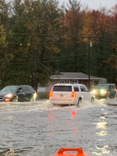
While widespread rain occurred across much of northwest lower Michigan, the worst flooding conditions were in and around Traverse City. Inland lakes, such as Lake Manuka near Gaylord, also experienced flooding thanks to the rain being exacerbated by already high water tables.
 |
|
|
 |
| S. Airport Rd & N. 3 Mile Rd - TVC Courtesy of Grand Traverse 911 |
S. Airport Rd & N. 3 Mile Rd - TVC Courtesy of Record Eagle |
Lake Manuka - Otsego County Courtesy of Keith Berger |
Lake Manuka - Otsego County Courtesy of Keith Berger |
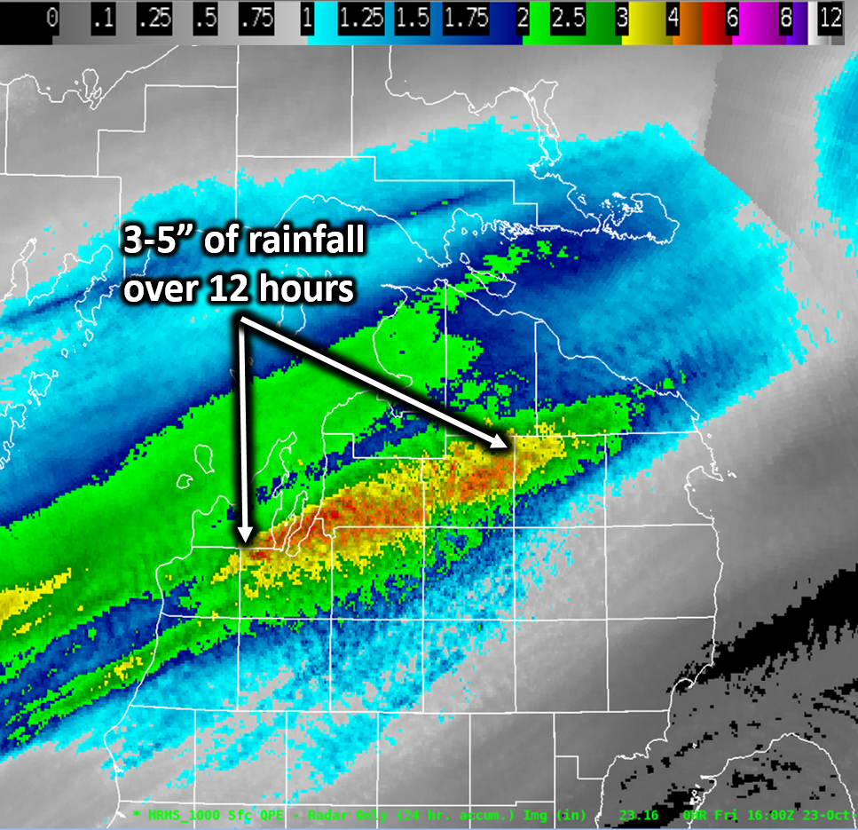
Radar-derived 24-hour total rainfall ending at Noon Friday. The majority of the heaviest rain occurred between 8:00pm Thursday and 8:00am Friday.
River Information
Many rivers across northern Michigan saw a spike in levels in response to the prolonged period of rainfall. The Jordan River near East Jordan and the Pigeon River near Vanderbilt both broke their long-time standing records by more than half a foot. The Jordan River crested at 7.10 feet, exceeding the old record of 6.51 feet set on July 19, 1975. The Pigeon River crested at 7.13 feet, exceeding the old record of 6.49 feet set on August 18, 1995. At the Pigeon River State Forest Campground roads were washed out and campsites were flooded and damaged. Other area rivers saw significant rises, as shown by the flooded dock on the Rapid River near Rapid City.
.png) |
|
.png) |
 |
| Jordan River near East Jordan, MI | Pigeon River near Vanderbilt, MI | Sturgeon River at Wolverine, MI | Platte River at Honor, MI |
 |
 |
 |
 |
| Jordan River Access Site, MI Courtesy of Luke Pennington |
Pigeon River State Forest Campground Courtesy of Anne Pfluecke |
Sturgeon River Campground Wolverine, MI Courtesy of Sherry Northrop |
Flooded Dock on Rapid River, Rapid City Courtesy of Patrick Swift |
Rainfall Reports
...THIS SHOWS THE HIGHEST 48 HOUR RAIN REPORTS, MOSTLY ENDING SATURDAY MORNING. THIS TABLE SHOWS A REPRESENTATION OF AVAILABLE READINGS IN EXCESS OF 2 INCHES FROM ACROSS THE REGION AND IS NOT MEANT TO BE EXHAUSTIVE... LOCATION AMOUNT TIME/DATE PROVIDER GAYLORD 2.2 SSE 5.16 IN 0726 AM 10/24 CWOP LAKE ANN 4.98 IN 0900 AM 10/23 PUBLIC TRAVERSE CITY 4.7 W 4.86 IN 0800 AM 10/24 COCORAHS GAYLORD 1.7 WNW 4.82 IN 0800 AM 10/24 COCORAHS MANCELONA 0.5 ESE 4.57 IN 0800 AM 10/24 COCORAHS TRAVERSE CITY MUNSON 4.35 IN 0609 AM 10/24 COOP GAYLORD 4.1 S 4.33 IN 0700 AM 10/24 COCORAHS ONEKAMA 1.8 NNW 4.11 IN 0700 AM 10/24 COCORAHS ATLANTA 3.91 IN 0708 AM 10/24 RAWS BEULAH 7 SSW 3.60 IN 0800 AM 10/24 COOP THE BEAR 3.58 IN 0708 AM 10/24 RAWS MANCELONA 3.56 IN 0730 AM 10/24 CWOP ROGERS CITY 0.2 WSW 3.02 IN 0800 AM 10/24 COCORAHS KINGSLEY 2.7 ENE 2.89 IN 0745 AM 10/24 COCORAHS HARBOR SPRINGS 0.7 ENE 2.63 IN 0700 AM 10/24 COCORAHS INDIAN RIVER 2.59 IN 0712 AM 10/24 RAWS CHARLEVOIX 2.57 IN 0800 AM 10/24 COOP MACKINAW CITY 1.1 ENE 2.23 IN 0700 AM 10/24 COCORAHS 4 W RACO 2.04 IN 0704 AM 10/24 RAWS TROUT LAKE 2.00 IN 0527 AM 10/24 RAWS |
 |
Media use of NWS Web News Stories is encouraged! Please acknowledge the NWS as the source of any news information accessed from this site. |
|


 Follow us on YouTube