Overview
|
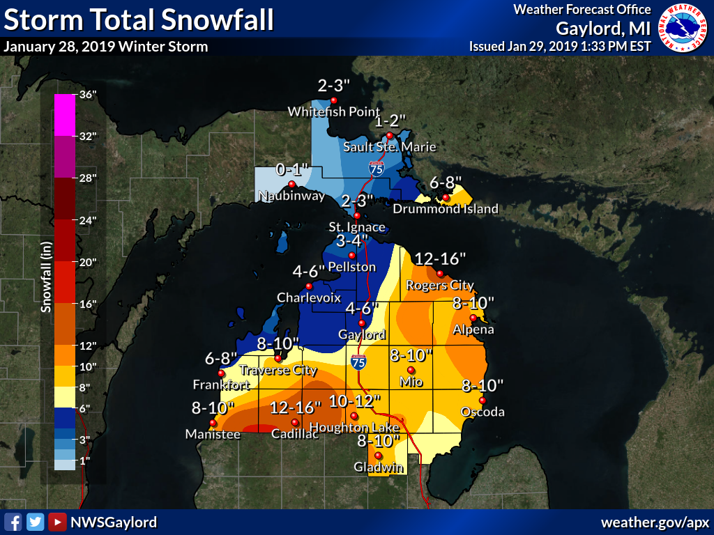
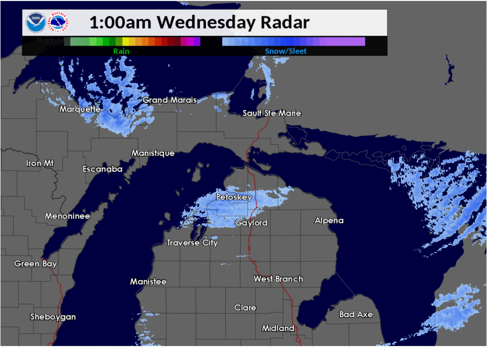
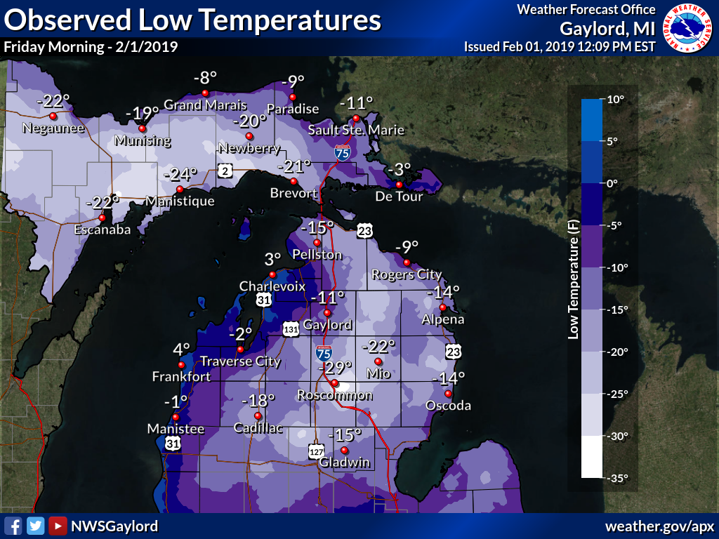
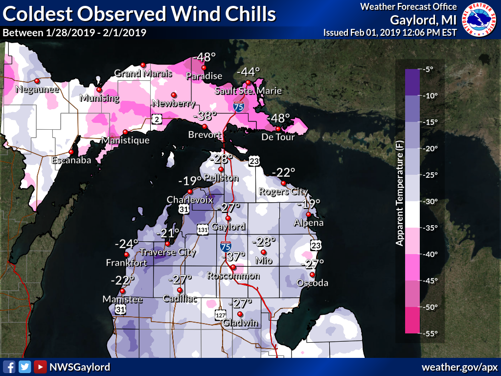
A brutally cold arctic air mass plunged into the Upper Midwest and Great Lakes regions during the last week of January 2019. While temperatures across northern Michigan did not drop as impressively low as in states just off to our west (thanks to the warming influence of the Great Lakes), it was still the coldest stretch of weather the area has seen in nearly four years, since February 2015. Many locations dropped below zero every night for more than a week, and a handful of daily temperature records were broken. Wind chills across northern Michigan generally ranged from 15 to 30 degrees below zero during the worst of the cold, dropping to dangerous levels at times (as cold as -51F in Kinross early Monday morning, January 28). In response to the brutal cold, Michigan's governor declared a state of emergency, which prompted most, if not all, northern Michigan schools to close for several days. State offices and other businesses were also closed at times due to the cold, and the US Postal Service temporarily suspended delivery across Michigan and other states. Sadly, the brutal cold resulted in 2 fatalities in Mackinac County. In addition to the cold, much of northern Michigan dealt with persistent snowfall for most of the week. An Alberta Clipper system brought widespread heavy snow to a large portion of the area on Monday, followed thereafter by robust lake effect snow showers across mainly northwest Lower and eastern Upper Michigan through midweek. Wednesday's gusty winds led to widespread significant blowing and drifting snow, resulting in near-blizzard conditions for some areas with whiteout conditions at times. Numerous accidents occurred as a result. |
 2-meter temperatures (right) and their departure from normal (left): 1/26 - 2/1/2019. 2-meter temperatures (right) and their departure from normal (left): 1/26 - 2/1/2019.Animation courtesy of The Pennsylvania State University Dept. of Meteorology. |
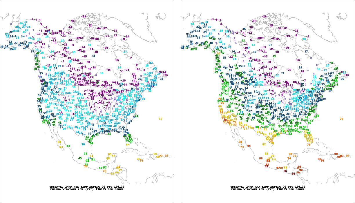 Observed daily minimum (left) and maximum (right) temperatures: 1/25 - 1/31/2019. Animation courtesy of The Pennsylvania State University Dept. of Meteorology. |
 MODIS satellite imagery showing rapid ice development on the Great Lakes: 1/21 - 2/1/2019. Animation courtesy of NASA Worldview. |
 |
 |
 |
 |
 |
Public Information Statement National Weather Service Gaylord MI 408 AM EST Mon Jan 28 2019 ...Coldest Wind Chills This Morning... Note: Only wind chill values of -20 F or colder have been included in this report. Location Temp Time/Date Lat/Lon Kinross - Chippewa County In -51 F 0356 AM 01/28 46.25N/84.47W 11 ESE Goetzville -50 F 0306 AM 01/28 45.99N/83.90W Dafter -46 F 0333 AM 01/28 46.37N/84.43W 4 NW Bay Mills -46 F 0336 AM 01/28 46.48N/84.63W 1 NNW Sault Ste. Marie -45 F 0330 AM 01/28 46.50N/84.37W 3 E Sault Ste. Marie -43 F 0142 AM 01/28 46.49N/84.30W Sault Ste Marie - Municipal -42 F 0355 AM 01/28 46.47N/84.37W 2 NNW Munuscong -42 F 0142 AM 01/28 46.28N/84.21W 3 SE Rudyard -41 F 0202 AM 01/28 46.19N/84.56W Drummond Island -39 F 0356 AM 01/28 46.01N/83.74W Mackinac Island -38 F 0355 AM 01/28 45.87N/84.64W 1 SSE Naubinway -38 F 0210 AM 01/28 46.09N/85.44W 4 W Raco -38 F 0304 AM 01/28 46.36N/84.80W 1 ESE Brevort -36 F 0332 AM 01/28 46.01N/85.01W 1 E Trout Lake -35 F 0327 AM 01/28 46.19N/84.98W 2 WSW Engadine -34 F 1102 PM 01/27 46.10N/85.62W 1 WNW Rexton -33 F 0313 AM 01/28 46.16N/85.27W Cheboygan - Cheboygan County -33 F 1215 AM 01/28 45.65N/84.53W Mackinaw City -32 F 1154 PM 01/27 45.78N/84.73W Kincheloe -31 F 1014 PM 01/27 46.24N/84.51W Oscoda - Wurtsmith AFB -29 F 1155 PM 01/27 44.42N/83.35W 1 S Mackinaw City -28 F 0218 AM 01/28 45.76N/84.73W 2 WNW Elmira -26 F 0329 AM 01/28 45.08N/84.89W 5 WNW Presque Isle -26 F 0132 AM 01/28 45.33N/83.58W Pellston - Rgnl Airport Of E -26 F 1254 AM 01/28 45.57N/84.80W 4 S Sid Town -26 F 0102 AM 01/28 44.38N/83.60W Rogers City - Presque Isle C -25 F 1235 AM 01/28 45.41N/83.81W Alpena - Phelps Collins Fiel -24 F 1154 PM 01/27 45.08N/83.56W Clear Lake State Park -24 F 1208 AM 01/28 45.15N/84.19W Wolverine -24 F 1217 AM 01/28 45.27N/84.59W Harbor Springs - Municipal A -24 F 0356 AM 01/28 45.42N/84.91W Beaver Island -24 F 0335 AM 01/28 45.69N/85.57W 2 SSE West Branch -23 F 0103 AM 01/28 44.25N/84.23W 1 NW Curran -23 F 1017 PM 01/27 44.73N/83.81W 2 WNW Metz -23 F 0300 AM 01/28 45.30N/83.85W 2 SE Roscommon -23 F 0110 AM 01/28 44.47N/84.57W Grayling - Army Airfield -22 F 0358 AM 01/28 44.68N/84.73W Harbor Springs -22 F 0330 AM 01/28 45.44N/84.99W Houghton Lake - Roscommon Co -22 F 1153 PM 01/27 44.35N/84.67W 2 S Indian River -22 F 1212 AM 01/28 45.38N/84.63W Ironton -20 F 0359 AM 01/28 45.26N/85.22W Gaylord - Otsego County Airp -20 F 0353 AM 01/28 45.02N/84.70W 2 SE East Tawas -20 F 0320 AM 01/28 44.26N/83.44W Observations are collected from a variety of sources with varying equipment and exposures. We thank all volunteer weather observers for their dedication. Not all data listed are considered official. $$ |
 |
 |
 |
 |
 |
Public Information Statement National Weather Service Gaylord MI 900 AM EST Tue Jan 29 2019 ...Coldest Wind Chills Monday Evening - Tuesday Morning... Location Temp Time/Date Lat/Lon 11 ESE Goetzville -33 F 0454 PM 01/28 45.99N/83.90W 4 NW Bay Mills -33 F 1018 PM 01/28 46.48N/84.63W Kinross - Chippewa County In -32 F 0450 PM 01/28 46.25N/84.47W Mackinac Island -30 F 0456 PM 01/28 45.87N/84.64W 1 NNW Sault Ste. Marie -30 F 0542 PM 01/28 46.50N/84.37W Dafter -29 F 0433 PM 01/28 46.37N/84.43W Pellston - Rgnl Airport Of E -27 F 0554 AM 01/29 45.57N/84.80W Sault Ste Marie - Municipal -26 F 0555 PM 01/28 46.47N/84.37W 1 S Mackinaw City -26 F 0617 AM 01/29 45.76N/84.73W Beaver Island -26 F 0536 PM 01/28 45.69N/85.57W Drummond Island -25 F 0636 PM 01/28 46.01N/83.74W Wolverine -22 F 0847 AM 01/29 45.27N/84.59W Evergreen Shores -21 F 0502 PM 01/28 45.90N/84.74W Harbor Springs - Municipal A -21 F 0415 AM 01/29 45.42N/84.91W Harbor Springs -20 F 0625 AM 01/29 45.44N/84.99W 1 E Norwood -17 F 0735 PM 01/28 45.24N/85.32W Observations are collected from a variety of sources with varying equipment and exposures. We thank all volunteer weather observers for their dedication. Not all data listed are considered official. $$ |
 |
 |
 |
 |
 |
Public Information Statement National Weather Service Gaylord MI 1033 AM EST Wed Jan 30 2019 ...Coldest Wind Chills Tuesday Night - Wednesday Morning... Location Temp Time/Date Lat/Lon ...Michigan... ...Alcona County... 1 NW Curran -26 F 0747 AM 01/30 44.73N/83.81W 1 SE Barton City -23 F 0246 AM 01/30 44.66N/83.59W ...Alpena County... 1 SSW Alpena -23 F 0840 AM 01/30 45.05N/83.45W 1 SE Lachine -23 F 0633 AM 01/30 45.07N/83.72W Alpena - Phelps Collins Fiel -22 F 0541 AM 01/30 45.08N/83.56W Alpena -19 F 0836 AM 01/30 45.06N/83.43W 1 SW Alpena -15 F 0902 AM 01/30 45.05N/83.45W ...Antrim County... 2 WNW Elmira -22 F 0545 AM 01/30 45.08N/84.89W Mancelona -21 F 0605 AM 01/30 44.90N/85.07W 1 NE Kewadin -17 F 0600 AM 01/30 44.95N/85.36W Bellarie - Antrim County Arp -16 F 0515 AM 01/30 44.99N/85.20W ...Benzie County... Frankfort - Dow Memorial Fie -24 F 0936 AM 01/30 44.63N/86.21W 2 S Benzonia -21 F 0947 AM 01/30 44.59N/86.10W 3 S Empire -19 F 0908 AM 01/30 44.76N/86.06W ...Charlevoix County... Beaver Island -19 F 0936 AM 01/30 45.69N/85.57W Charlevoix - Municipal Arpt -17 F 1015 AM 01/30 45.30N/85.27W Ironton -17 F 0129 AM 01/30 45.26N/85.22W 3 W Bayshore -17 F 0948 AM 01/30 45.36N/85.18W ...Cheboygan County... Mackinaw City -20 F 0224 AM 01/30 45.78N/84.73W Wolverine -18 F 0348 AM 01/30 45.27N/84.59W Cheboygan - Cheboygan County -18 F 0636 AM 01/30 45.65N/84.53W 1 S Mackinaw City -15 F 0302 AM 01/30 45.76N/84.73W ...Chippewa County... Kinross - Chippewa County In -28 F 0556 AM 01/30 46.25N/84.47W 3 E Sault Ste. Marie -28 F 0712 AM 01/30 46.49N/84.30W Dafter -28 F 0648 AM 01/30 46.37N/84.43W 4 NW Bay Mills -28 F 0654 AM 01/30 46.48N/84.63W 1 NNW Sault Ste. Marie -26 F 0706 AM 01/30 46.50N/84.37W Sault Ste Marie - Municipal -23 F 0655 AM 01/30 46.47N/84.37W Drummond Island -21 F 0835 AM 01/30 46.01N/83.74W 3 SE Rudyard -18 F 0717 AM 01/30 46.19N/84.56W 4 W Raco -18 F 0604 AM 01/30 46.36N/84.80W ...Crawford County... Grayling - Army Airfield -29 F 0723 AM 01/30 44.68N/84.73W 3 S Grayling -25 F 0817 AM 01/30 44.61N/84.71W 2 SSW Hartwick Pines State P -21 F 0612 AM 01/30 44.72N/84.71W ...Emmet County... Pellston - Rgnl Airport Of E -19 F 0808 AM 01/30 45.57N/84.80W Petoskey -15 F 1003 AM 01/30 45.36N/84.95W Harbor Springs - Municipal A -15 F 0956 AM 01/30 45.42N/84.91W ...Grand Traverse County... Williamsburg -21 F 0532 AM 01/30 44.77N/85.40W Traverse City - Cherry Capit -20 F 1011 AM 01/30 44.74N/85.58W 3 S Elk Rapids -18 F 0600 AM 01/30 44.84N/85.41W 2 NNE Mapleton -17 F 0600 AM 01/30 44.93N/85.50W ...Iosco County... Oscoda - Wurtsmith AFB -28 F 0915 AM 01/30 44.42N/83.35W 2 SE East Tawas -27 F 0650 AM 01/30 44.26N/83.44W East Tawas -25 F 0516 AM 01/30 44.28N/83.48W 4 S Sid Town -22 F 0802 AM 01/30 44.38N/83.60W 4 W Sid Town -20 F 0802 AM 01/30 44.45N/83.69W ...Kalkaska County... 1 SW Kalkaska -26 F 0602 AM 01/30 44.72N/85.19W 1 WSW Sigma -24 F 0600 AM 01/30 44.66N/85.07W 5 NE Darragh -20 F 0600 AM 01/30 44.83N/84.98W ...Leelanau County... 3 SW Maple City -23 F 0902 AM 01/30 44.81N/85.90W Bingham -21 F 0300 AM 01/30 44.88N/85.68W 6 NE Northport -20 F 1000 AM 01/30 45.21N/85.55W 3 W Peshawbestown -16 F 0300 AM 01/30 45.03N/85.67W 1 W Northport -16 F 0900 AM 01/30 45.14N/85.65W 12 WNW Leland -15 F 0828 AM 01/30 45.12N/85.98W ...Mackinac County... 2 WSW Engadine -24 F 0932 AM 01/30 46.10N/85.62W Mackinac Island -19 F 0816 AM 01/30 45.87N/84.64W 1 ESE Brevort -15 F 0902 AM 01/30 46.01N/85.01W ...Manistee County... Manistee - Blacker Airport -27 F 0356 AM 01/30 44.27N/86.25W 1 SE Manistee -25 F 0932 AM 01/30 44.22N/86.31W 3 WSW Onekama -21 F 0501 AM 01/30 44.35N/86.27W ...Missaukee County... 3 W Vogel Center -31 F 0900 AM 01/30 44.19N/85.13W 4 N Jennings -24 F 0900 AM 01/30 44.40N/85.29W ...Montmorency County... 2 W Lewiston -19 F 0529 AM 01/30 44.89N/84.36W Clear Lake State Park -18 F 0708 AM 01/30 45.15N/84.19W ...Ogemaw County... 2 SSE West Branch -27 F 0832 AM 01/30 44.25N/84.23W ...Oscoda County... Mio -26 F 0800 AM 01/30 44.68N/84.13W ...Otsego County... Gaylord - Otsego County Airp -29 F 0509 AM 01/30 45.02N/84.70W 2 S Elmira -25 F 0600 AM 01/30 45.03N/84.85W 1 WNW Waters -24 F 0614 AM 01/30 44.91N/84.72W ...Presque Isle County... 5 WNW Presque Isle -20 F 0733 AM 01/30 45.33N/83.58W Rogers City - Presque Isle C -18 F 0855 AM 01/30 45.41N/83.81W Rogers City -15 F 0420 AM 01/30 45.42N/83.81W ...Roscommon County... Houghton Lake - Roscommon Co -30 F 0942 AM 01/30 44.35N/84.67W 3 NW Houghton Lake -27 F 0902 AM 01/30 44.33N/84.81W 2 SE Roscommon -26 F 0810 AM 01/30 44.47N/84.57W ...Wexford County... Cadillac - Wexford Count Arp -26 F 0556 AM 01/30 44.28N/85.42W 4 SW Fife Lake -23 F 0702 AM 01/30 44.51N/85.40W 6 ENE Dublin -22 F 0347 AM 01/30 44.22N/85.81W ...Maritime Stations... 11 ESE Goetzville -26 F 0954 AM 01/30 45.99N/83.90W 2 NNW Munuscong -25 F 0806 AM 01/30 46.28N/84.21W 1 SSE Naubinway -18 F 0940 AM 01/30 46.09N/85.44W 5 SW Beaver Island -16 F 0915 AM 01/30 45.63N/85.61W Observations are collected from a variety of sources with varying equipment and exposures. We thank all volunteer weather observers for their dedication. Not all data listed are considered official. $$ |
 |
 |
 |
 |
 |
Public Information Statement National Weather Service Gaylord MI 1019 AM EST Thu Jan 31 2019 ...Coldest Wind Chills Wednesday Night - Thursday Morning... Location Temp Time/Date Lat/Lon ...Michigan... ...Alcona County... 1 NW Curran -22 F 0747 AM 01/31 44.73N/83.81W 1 SE Barton City -20 F 0746 AM 01/31 44.66N/83.59W ...Alpena County... Alpena - Phelps Collins Fiel -19 F 0754 AM 01/31 45.08N/83.56W 1 SSW Alpena -19 F 0900 AM 01/31 45.05N/83.45W 1 SE Lachine -18 F 0902 AM 01/31 45.07N/83.72W ...Antrim County... 2 WNW Elmira -19 F 0629 AM 01/31 45.08N/84.89W Mancelona -18 F 0835 AM 01/31 44.90N/85.07W ...Benzie County... Frankfort - Dow Memorial Fie -21 F 0835 AM 01/31 44.63N/86.21W 2 S Benzonia -18 F 0817 AM 01/31 44.59N/86.10W 3 S Empire -15 F 0708 AM 01/31 44.76N/86.06W ...Charlevoix County... Beaver Island -19 F 0755 AM 01/31 45.69N/85.57W Charlevoix - Municipal Arpt -18 F 0755 AM 01/31 45.30N/85.27W Ironton -18 F 0849 AM 01/31 45.26N/85.22W 3 W Bayshore -17 F 0918 AM 01/31 45.36N/85.18W ...Cheboygan County... Mackinaw City -25 F 0848 AM 01/31 45.78N/84.73W Cheboygan - Cheboygan County -21 F 0755 AM 01/31 45.65N/84.53W Wolverine -18 F 0917 AM 01/31 45.27N/84.59W ...Chippewa County... 3 E Sault Ste. Marie -26 F 0906 AM 01/31 46.49N/84.30W Kinross - Chippewa County In -25 F 0656 AM 01/31 46.25N/84.47W 4 W Raco -25 F 0904 AM 01/31 46.36N/84.80W 1 NNW Sault Ste. Marie -25 F 0918 AM 01/31 46.50N/84.37W Sault Ste Marie - Municipal -23 F 0917 AM 01/31 46.47N/84.37W Drummond Island -23 F 0735 AM 01/31 46.01N/83.74W Dafter -21 F 0733 AM 01/31 46.37N/84.43W 3 SE Rudyard -20 F 0648 AM 01/31 46.19N/84.56W 1 E Trout Lake -20 F 0827 AM 01/31 46.19N/84.98W ...Crawford County... Grayling - Army Airfield -21 F 0558 AM 01/31 44.68N/84.73W 3 S Grayling -19 F 0847 AM 01/31 44.61N/84.71W 2 SSW Hartwick Pines State P -15 F 0612 AM 01/31 44.72N/84.71W ...Emmet County... Pellston - Rgnl Airport Of E -19 F 0954 AM 01/31 45.57N/84.80W Petoskey -16 F 0648 AM 01/31 45.36N/84.95W Harbor Springs -16 F 0745 AM 01/31 45.44N/84.99W Harbor Springs - Municipal A -15 F 0735 AM 01/31 45.42N/84.91W ...Grand Traverse County... Williamsburg -17 F 0802 AM 01/31 44.77N/85.40W Traverse City - Cherry Capit -17 F 0853 AM 01/31 44.74N/85.58W 3 S Elk Rapids -15 F 0900 AM 01/31 44.84N/85.41W ...Iosco County... Oscoda - Wurtsmith AFB -30 F 0835 AM 01/31 44.42N/83.35W 2 SE East Tawas -26 F 0700 AM 01/31 44.26N/83.44W 4 W Sid Town -23 F 0717 AM 01/31 44.45N/83.69W 4 S Sid Town -23 F 0802 AM 01/31 44.38N/83.60W East Tawas -20 F 0412 AM 01/31 44.28N/83.48W ...Kalkaska County... 1 SW Kalkaska -20 F 0832 AM 01/31 44.72N/85.19W 1 WSW Sigma -19 F 0900 AM 01/31 44.66N/85.07W ...Leelanau County... 3 SW Maple City -21 F 0632 AM 01/31 44.81N/85.90W 6 NE Northport -20 F 0920 AM 01/31 45.21N/85.55W Bingham -19 F 0900 AM 01/31 44.88N/85.68W 3 W Peshawbestown -16 F 0900 AM 01/31 45.03N/85.67W 1 W Northport -16 F 0900 AM 01/31 45.14N/85.65W ...Mackinac County... 2 WSW Engadine -33 F 0933 AM 01/31 46.10N/85.62W Mackinac Island -29 F 0636 AM 01/31 45.87N/84.64W 1 WNW Rexton -25 F 0813 AM 01/31 46.16N/85.27W 1 ESE Brevort -24 F 0747 AM 01/31 46.01N/85.01W Evergreen Shores -19 F 0617 AM 01/31 45.90N/84.74W ...Manistee County... Manistee - Blacker Airport -22 F 0456 AM 01/31 44.27N/86.25W 1 SE Manistee -19 F 0917 AM 01/31 44.22N/86.31W 3 WSW Onekama -18 F 0716 AM 01/31 44.35N/86.27W ...Missaukee County... 3 W Vogel Center -25 F 0900 AM 01/31 44.19N/85.13W 4 N Jennings -18 F 0900 PM 01/30 44.40N/85.29W ...Montmorency County... Clear Lake State Park -14 F 0708 AM 01/31 45.15N/84.19W ...Ogemaw County... 3 ESE West Branch -31 F 0755 AM 01/31 44.24N/84.18W 2 SSE West Branch -31 F 0817 AM 01/31 44.25N/84.23W ...Oscoda County... Mio -23 F 0800 AM 01/31 44.68N/84.13W ...Otsego County... Gaylord - Otsego County Airp -23 F 0853 AM 01/31 45.02N/84.70W 2 S Elmira -17 F 0900 AM 01/31 45.03N/84.85W 1 WNW Waters -15 F 0359 AM 01/31 44.91N/84.72W ...Presque Isle County... 5 WNW Presque Isle -16 F 0817 AM 01/31 45.33N/83.58W Rogers City - Presque Isle C -15 F 0915 AM 01/31 45.41N/83.81W ...Roscommon County... 2 SE Roscommon -33 F 0810 AM 01/31 44.47N/84.57W Houghton Lake - Roscommon Co -26 F 0253 AM 01/31 44.35N/84.67W 3 NW Houghton Lake -23 F 0632 AM 01/31 44.33N/84.81W ...Wexford County... Cadillac - Wexford Count Arp -24 F 0736 AM 01/31 44.28N/85.42W 6 ENE Dublin -17 F 0802 AM 01/31 44.22N/85.81W 4 SW Fife Lake -16 F 0747 AM 01/31 44.51N/85.40W ...Maritime Stations... 1 SSE Naubinway -31 F 0740 AM 01/31 46.09N/85.44W 2 NNW Munuscong -26 F 0748 AM 01/31 46.28N/84.21W 11 ESE Goetzville -25 F 0630 AM 01/31 45.99N/83.90W 5 SW Beaver Island -17 F 0845 AM 01/31 45.63N/85.61W Observations are collected from a variety of sources with varying equipment and exposures. We thank all volunteer weather observers for their dedication. Not all data listed are considered official. $$ |
 |
 |
 |
PUBLIC INFORMATION STATEMENT
NATIONAL WEATHER SERVICE GAYLORD MI
900 AM EST FRI FEB 1 2019
...Coldest Wind Chills Thursday Night - Friday Morning... Location Temp Time/Date Lat/Lon ...Michigan... ...Alcona County... 1 SE Barton City -26 F 1246 AM 02/01 44.66N/83.59W 1 NW Curran -20 F 0102 AM 02/01 44.73N/83.81W ...Alpena County... Alpena - Phelps Collins Fiel -25 F 0954 AM 02/01 45.08N/83.56W Alpena -25 F 0806 AM 02/01 45.06N/83.43W 1 SE Lachine -23 F 0832 AM 02/01 45.07N/83.72W 1 SSW Alpena -21 F 0750 AM 02/01 45.05N/83.45W 1 SW Alpena -15 F 0801 AM 02/01 45.05N/83.45W ...Antrim County... 2 WNW Elmira -18 F 1029 PM 01/31 45.08N/84.89W ...Cheboygan County... Cheboygan - Cheboygan County -27 F 0155 AM 02/01 45.65N/84.53W 1 S Mackinaw City -22 F 0317 AM 02/01 45.76N/84.73W Wolverine -20 F 1117 PM 01/31 45.27N/84.59W ...Chippewa County... 3 E Sault Ste. Marie -26 F 0812 AM 02/01 46.49N/84.30W Kinross - Chippewa County In -25 F 0756 AM 02/01 46.25N/84.47W 3 SE Rudyard -25 F 0902 AM 02/01 46.19N/84.56W 4 NW Bay Mills -25 F 0918 AM 02/01 46.48N/84.63W 1 E Trout Lake -25 F 0827 AM 02/01 46.19N/84.98W 4 W Raco -21 F 0504 AM 02/01 46.36N/84.80W Kincheloe -21 F 1214 AM 02/01 46.24N/84.51W Dafter -20 F 0633 AM 02/01 46.37N/84.43W 1 NNW Sault Ste. Marie -20 F 0948 AM 02/01 46.50N/84.37W Sault Ste Marie - Municipal -17 F 1155 PM 01/31 46.47N/84.37W ...Crawford County... Grayling - Army Airfield -30 F 0858 PM 01/31 44.68N/84.73W 3 S Grayling -27 F 0203 AM 02/01 44.61N/84.71W 2 SSW Hartwick Pines State P -16 F 1112 PM 01/31 44.72N/84.71W ...Emmet County... Pellston - Rgnl Airport Of E -26 F 0554 AM 02/01 45.57N/84.80W ...Iosco County... Oscoda - Wurtsmith AFB -29 F 0256 AM 02/01 44.42N/83.35W 4 S Sid Town -26 F 0902 AM 02/01 44.38N/83.60W 4 W Sid Town -24 F 0203 AM 02/01 44.45N/83.69W 2 SE East Tawas -23 F 0450 AM 02/01 44.26N/83.44W East Tawas -17 F 0151 AM 02/01 44.28N/83.48W ...Kalkaska County... 1 SW Kalkaska -25 F 1047 PM 01/31 44.72N/85.19W 5 NE Darragh -16 F 1200 AM 02/01 44.83N/84.98W ...Leelanau County... 3 SW Maple City -18 F 0933 PM 01/31 44.81N/85.90W ...Mackinac County... 2 WSW Engadine -33 F 1247 AM 02/01 46.10N/85.62W 1 ESE Brevort -32 F 0632 AM 02/01 46.01N/85.01W Mackinac Island -23 F 0735 AM 02/01 45.87N/84.64W 1 WNW Rexton -23 F 0813 AM 02/01 46.16N/85.27W Evergreen Shores -20 F 0617 AM 02/01 45.90N/84.74W ...Montmorency County... Clear Lake State Park -23 F 0408 AM 02/01 45.15N/84.19W 2 W Lewiston -22 F 0414 AM 02/01 44.89N/84.36W ...Ogemaw County... 3 ESE West Branch -31 F 0436 AM 02/01 44.24N/84.18W 2 SSE West Branch -21 F 0232 AM 02/01 44.25N/84.23W ...Oscoda County... Mio -26 F 0800 AM 02/01 44.68N/84.13W 1 E Fairview -16 F 0853 AM 02/01 44.71N/84.02W ...Otsego County... Gaylord - Otsego County Airp -23 F 0853 PM 01/31 45.02N/84.70W 2 S Elmira -23 F 0900 PM 01/31 45.03N/84.85W ...Presque Isle County... 5 WNW Presque Isle -30 F 0632 AM 02/01 45.33N/83.58W Rogers City - Presque Isle C -21 F 1156 PM 01/31 45.41N/83.81W 2 WNW Metz -20 F 0800 AM 02/01 45.30N/83.85W Rogers City -18 F 0835 AM 02/01 45.42N/83.81W ...Roscommon County... 2 SE Roscommon -31 F 0210 AM 02/01 44.47N/84.57W Houghton Lake - Roscommon Co -27 F 1153 PM 01/31 44.35N/84.67W 3 NW Houghton Lake -26 F 0217 AM 02/01 44.33N/84.81W ...Wexford County... Cadillac - Wexford Count Arp -19 F 0156 AM 02/01 44.28N/85.42W 4 SW Fife Lake -18 F 1147 PM 01/31 44.51N/85.40W 6 ENE Dublin -18 F 0202 AM 02/01 44.22N/85.81W ...Maritime Stations... 1 SSE Naubinway -32 F 0740 AM 02/01 46.09N/85.44W 2 NNW Munuscong -29 F 0742 AM 02/01 46.28N/84.21W 11 ESE Goetzville -17 F 0954 PM 01/31 45.99N/83.90W Observations are collected from a variety of sources with varying equipment and exposures. We thank all volunteer weather observers for their dedication. Not all data listed are considered official. $$ |
 925 mb heights and temperatures: 1/26 - 2/1/2019. Animation courtesy of Plymouth State University. |
 850 mb heights and temperatures: 1/26 - 2/1/2019. Animation courtesy of Plymouth State University. |
 500 mb heights and temperatures: 1/26 - 2/1/2019. Animation courtesy of Plymouth State University. |
 |
 |
 |
Media use of NWS Web News Stories is encouraged! Please acknowledge the NWS as the source of any news information accessed from this site. |
|


 Follow us on YouTube