Overview
|
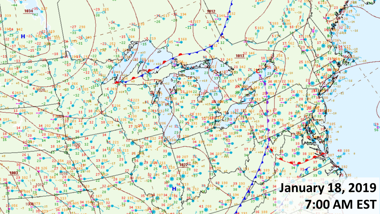
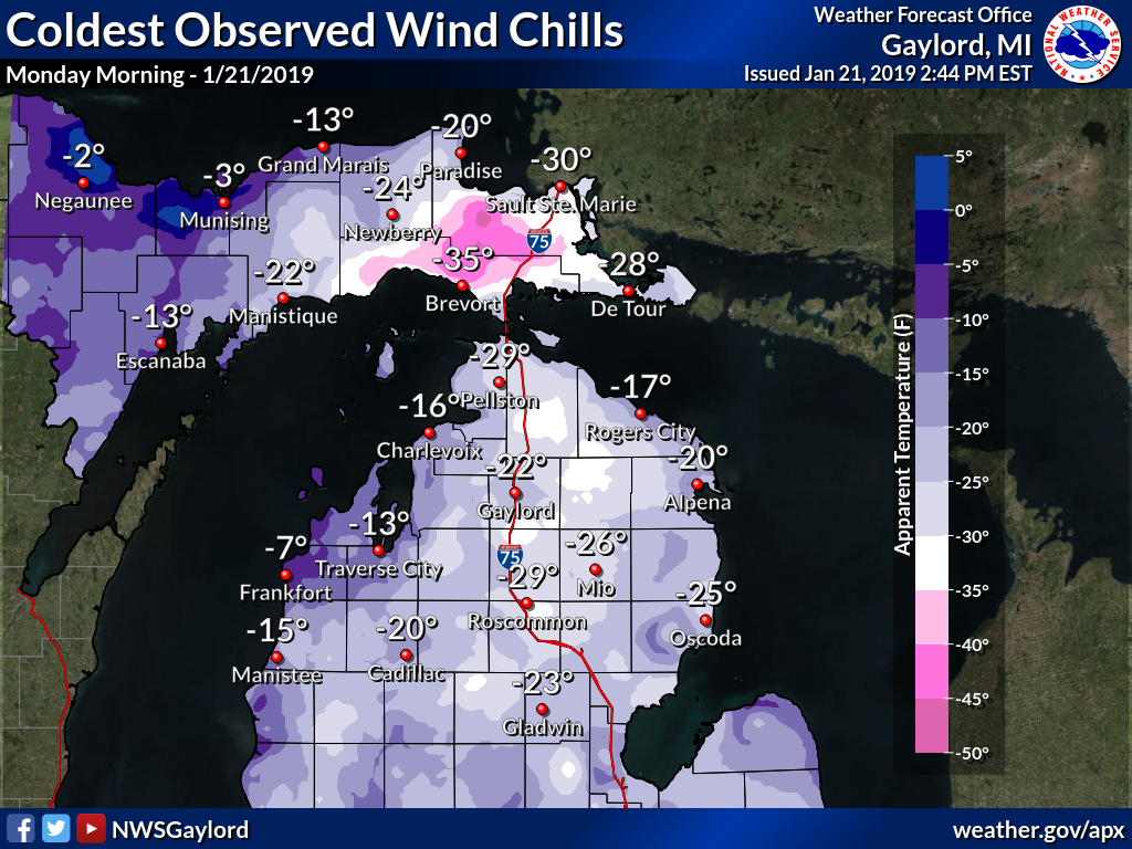
Canadian high pressure and an accompanying Arctic airmass gradually settled over the Upper Great Lakes over the weekend of January 18-21. With such frigid temperatures in place, even light winds were sufficient to produce bitter cold wind chills of 20 to 40 below zero at times for a portion of northern Michigan. The plunge in temperatures led to area rivers quickly icing up with some minor ice jam flooding occurring in spots. Ice formation was also accelerated on the Upper Great Lakes, especially Whitefish Bay and the Straits region. Many schools across northern Michigan were also closed Monday morning due to the dangerously cold conditions. |
 |
 |
 |
PUBLIC INFORMATION STATEMENT
NATIONAL WEATHER SERVICE GAYLORD MI
1100 AM EST SAT JAN 19 2019
...LOW TEMPERATURES SATURDAY MORNING...

Location                     Temp      Time/Date       Lat/Lon

...Michigan...

...Alcona County...
1 NW Curran                    7 F     0918 AM 01/19   44.73N/83.81W

...Alpena County...
1 SE Lachine                   5 F     0833 AM 01/19   45.07N/83.72W
Alpena - Phelps Collins Fiel   7 F     1103 AM 01/19   45.08N/83.56W
5 S Cathro                     7 F     1100 AM 01/19   45.07N/83.57W
Alpena                         8 F     1106 AM 01/19   45.06N/83.43W

...Antrim County...
2 WNW Elmira                   4 F     1059 AM 01/19   45.08N/84.89W
Mancelona                      5 F     0930 AM 01/19   44.90N/85.07W
Eastport                       7 F     0847 AM 01/19   45.11N/85.35W
1 ENE Torch Lake               7 F     0900 AM 01/19   45.08N/85.34W
1 NE Kewadin                   8 F     0900 AM 01/19   44.95N/85.36W

...Benzie County...
Beulah 7ssw                    8 F     0800 AM 01/19   44.53N/86.13W
4 SSW Benzonia                 8 F     0900 AM 01/19   44.56N/86.12W

...Charlevoix County...
Beaver Island                  2 F     0935 AM 01/19   45.69N/85.57W
2 NNW East Jordan              7 F     1030 AM 01/19   45.19N/85.15W
Ironton                        7 F     1113 AM 01/19   45.26N/85.22W
Charlevoix                     8 F     0800 AM 01/19   45.32N/85.27W
3 W Bayshore                   8 F     1002 AM 01/19   45.36N/85.18W

...Cheboygan County...
Mackinaw City                  0 F     0900 AM 01/19   45.78N/84.72W
Wolverine                      4 F     1047 AM 01/19   45.27N/84.59W
6 E Cheboygan                  5 F     1109 AM 01/19   45.66N/84.33W
2 SSW Indian River             5 F     1100 AM 01/19   45.38N/84.63W
Cheboygan                      5 F     1115 AM 01/19   45.65N/84.53W
2 S Indian River               6 F     0812 AM 01/19   45.38N/84.63W

...Chippewa County...
Dafter                       -16 F     0904 AM 01/19   46.37N/84.43W
Sault Ste Marie              -15 F     0800 AM 01/19   46.49N/84.40W
Kinross - Chippewa County In -14 F     0856 AM 01/19   46.25N/84.47W
3 E Sault Ste. Marie         -14 F     0936 AM 01/19   46.49N/84.30W
4 W Raco                     -13 F     0904 AM 01/19   46.36N/84.80W
Kincheloe                    -13 F     0914 AM 01/19   46.24N/84.51W
1 NNW Sault Ste. Marie       -13 F     1000 AM 01/19   46.50N/84.37W
1 E Trout Lake               -13 F     0827 AM 01/19   46.19N/84.98W
Sault Ste. Marie             -12 F     1000 AM 01/19   46.49N/84.36W
4 NW Bay Mills               -11 F     0948 AM 01/19   46.48N/84.63W
Drummond Island               -8 F     1055 AM 01/19   46.01N/83.74W
3 SE Rudyard                  -8 F     1032 AM 01/19   46.19N/84.56W

...Crawford County...
Grayling - Army Airfield       5 F     0958 AM 01/19   44.68N/84.73W
2 SSW Hartwick Pines State P   5 F     0812 AM 01/19   44.72N/84.71W
Grayling                       5 F     1000 AM 01/19   44.66N/84.70W
3 S Grayling                   6 F     1032 AM 01/19   44.61N/84.71W

...Emmet County...
1 NNE Clarion                  4 F     0515 AM 01/19   45.30N/84.90W
Harbor Springs                 5 F     0605 AM 01/19   45.44N/84.99W
Harbor Springs - Municipal A   6 F     0955 AM 01/19   45.42N/84.91W
Pellston - Rgnl Airport Of E   6 F     1054 AM 01/19   45.57N/84.80W
Petoskey Ncmc                  6 F     0800 AM 01/19   45.36N/84.95W

...Grand Traverse County...
1 NNW Fife Lake                5 F     0700 AM 01/19   44.58N/85.35W
1 SSW Grawn                    6 F     0851 AM 01/19   44.64N/85.69W
Williamsburg                   8 F     0917 AM 01/19   44.77N/85.40W
3 S Elk Rapids                 8 F     0900 AM 01/19   44.84N/85.41W

...Kalkaska County...
5 NE Darragh                   4 F     0930 AM 01/19   44.83N/84.98W
1 SW Kalkaska                  6 F     0802 AM 01/19   44.72N/85.19W
1 WSW Sigma                    6 F     0900 AM 01/19   44.66N/85.07W

...Leelanau County...
3 SW Maple City                8 F     0847 AM 01/19   44.81N/85.90W
3 W Peshawbestown              8 F     0900 AM 01/19   45.03N/85.67W
1 W Northport                  8 F     0900 AM 01/19   45.14N/85.65W

...Mackinac County...
1 WNW Rexton                 -11 F     0913 AM 01/19   46.16N/85.27W
2 WSW Engadine               -10 F     0903 AM 01/19   46.10N/85.62W
1 ESE Brevort                 -9 F     0917 AM 01/19   46.01N/85.01W
Moran                         -9 F     0800 AM 01/19   45.99N/84.84W
Evergreen Shores               0 F     1017 AM 01/19   45.90N/84.74W
Mackinac Island                0 F     0835 AM 01/19   45.87N/84.64W

...Manistee County...
Wellston                       8 F     0920 AM 01/19   44.23N/85.96W
2 E Onekama                    8 F     1000 AM 01/19   44.37N/86.16W

...Missaukee County...
4 N Jennings                   6 F     0900 AM 01/19   44.40N/85.29W
3 W Vogel Center               7 F     0600 AM 01/19   44.19N/85.13W

...Montmorency County...
Clear Lake State Park          4 F     0908 AM 01/19   45.15N/84.19W
2 W Lewiston                   4 F     0959 AM 01/19   44.89N/84.36W

...Ogemaw County...
3 WSW Selkirk                  8 F     1000 AM 01/19   44.30N/84.13W
2 SSE West Branch              9 F     0632 AM 01/19   44.25N/84.23W

...Oscoda County...
1 E Fairview                   5 F     0903 AM 01/19   44.71N/84.02W
1 SW Mio                       5 F     1000 AM 01/19   44.65N/84.15W
Mio                            6 F     0900 AM 01/19   44.68N/84.13W

...Otsego County...
Gaylord - Otsego County Airp   3 F     0953 AM 01/19   45.02N/84.70W
Gaylord 9 SSW                  3 F     1045 AM 01/19   44.91N/84.72W
2 S Elmira                     3 F     0900 AM 01/19   45.03N/84.85W
Gaylord                        4 F     0800 AM 01/19   45.03N/84.68W
1 SSE Waters                   4 F     1002 AM 01/19   44.88N/84.69W
9 SSW Gaylord                  7 F     1200 AM 01/19   44.91N/84.72W

...Presque Isle County...
5 WNW Presque Isle             4 F     1032 AM 01/19   45.33N/83.58W
2 WNW Metz                     4 F     1100 AM 01/19   45.30N/83.85W
Rogers City                    5 F     1110 AM 01/19   45.42N/83.81W
Rogers City - Presque Isle C   5 F     1116 AM 01/19   45.41N/83.81W

...Roscommon County...
2 SE Roscommon                 7 F     0910 AM 01/19   44.47N/84.57W
Houghton Lake - Roscommon Co   8 F     1028 AM 01/19   44.35N/84.67W
3 NW Houghton Lake             8 F     0933 AM 01/19   44.33N/84.81W

...Wexford County...
Cadillac - Wexford Count Arp   7 F     0735 AM 01/19   44.28N/85.42W
4 SW Fife Lake                 7 F     0947 AM 01/19   44.51N/85.40W
1 WNW Cadillac                 7 F     0800 AM 01/19   44.26N/85.44W

...Maritime Stations...
24 E Harrisville             -15 F     1000 AM 01/19   44.70N/82.80W
2 NNW Munuscong              -13 F     0954 AM 01/19   46.28N/84.21W
Detour Village                -8 F     0800 AM 01/19   46.02N/83.92W
11 ESE Goetzville             -7 F     1112 AM 01/19   45.99N/83.90W
1 SSE Naubinway               -7 F     0930 AM 01/19   46.09N/85.44W
5 SW Beaver Island             4 F     1015 AM 01/19   45.63N/85.61W

Observations are collected from a variety of sources with varying
equipment and exposures. We thank all volunteer weather observers
for their dedication. Not all data listed are considered official.

$$
|
PUBLIC INFORMATION STATEMENT
NATIONAL WEATHER SERVICE GAYLORD MI
1100 AM EST SAT JAN 19 2019
...COLDEST WIND CHILLS FRIDAY NIGHT - SATURDAY MORNING...

Location                     Temp      Time/Date       Lat/Lon

...Michigan...

...Alcona County...
1 NW Curran                   -6 F     1018 AM 01/19   44.73N/83.81W
1 SE Barton City              -1 F     1046 PM 01/18   44.66N/83.59W

...Alpena County...
Alpena - Phelps Collins Fiel -10 F     1036 AM 01/19   45.08N/83.56W
1 SE Lachine                  -8 F     1048 AM 01/19   45.07N/83.72W
Alpena                        -5 F     1042 AM 01/19   45.06N/83.43W

...Antrim County...
2 WNW Elmira                 -14 F     1044 AM 01/19   45.08N/84.89W
1 NE Kewadin                  -7 F     0900 AM 01/19   44.95N/85.36W
1 ENE Torch Lake              -6 F     0900 AM 01/19   45.08N/85.34W
Bellarie - Antrim County Arp  -5 F     1035 AM 01/19   44.99N/85.20W
Mancelona                     -5 F     1020 AM 01/19   44.90N/85.07W
Eastport                      -4 F     0847 AM 01/19   45.11N/85.35W

...Benzie County...
Frankfort - Dow Memorial Fie  -2 F     0835 AM 01/19   44.63N/86.21W
2 S Benzonia                  -1 F     0617 AM 01/19   44.59N/86.10W
3 S Empire                     0 F     0908 AM 01/19   44.76N/86.06W

...Charlevoix County...
Beaver Island                -12 F     0915 AM 01/19   45.69N/85.57W
Ironton                       -9 F     1039 AM 01/19   45.26N/85.22W
Charlevoix - Municipal Arpt   -7 F     1016 AM 01/19   45.30N/85.27W
2 NNW East Jordan             -6 F     1115 PM 01/18   45.19N/85.15W
3 W Bayshore                  -4 F     1032 PM 01/18   45.36N/85.18W

...Cheboygan County...
Mackinaw City                -16 F     1048 AM 01/19   45.78N/84.73W
1 S Mackinaw City            -13 F     0447 AM 01/19   45.76N/84.73W
Wolverine                    -11 F     1047 AM 01/19   45.27N/84.59W
Cheboygan - Cheboygan County -10 F     1036 AM 01/19   45.65N/84.53W
6 E Cheboygan                 -5 F     0854 AM 01/19   45.66N/84.33W
2 S Indian River              -4 F     1012 AM 01/19   45.38N/84.63W

...Chippewa County...
3 E Sault Ste. Marie         -35 F     0906 AM 01/19   46.49N/84.30W
4 NW Bay Mills               -33 F     0930 AM 01/19   46.48N/84.63W
1 NNW Sault Ste. Marie       -33 F     0812 AM 01/19   46.50N/84.37W
Dafter                       -32 F     1004 AM 01/19   46.37N/84.43W
Kinross - Chippewa County In -31 F     0856 AM 01/19   46.25N/84.47W
Sault Ste Marie - Municipal  -29 F     0855 AM 01/19   46.47N/84.37W
Kincheloe                    -28 F     1014 AM 01/19   46.24N/84.51W
3 SE Rudyard                 -25 F     1032 AM 01/19   46.19N/84.56W
4 W Raco                     -24 F     0904 AM 01/19   46.36N/84.80W
1 E Trout Lake               -22 F     0927 AM 01/19   46.19N/84.98W
Drummond Island              -21 F     0955 AM 01/19   46.01N/83.74W

...Crawford County...
Grayling - Army Airfield     -11 F     0923 AM 01/19   44.68N/84.73W
3 S Grayling                  -5 F     1032 AM 01/19   44.61N/84.71W
2 SSW Hartwick Pines State P  -3 F     0812 AM 01/19   44.72N/84.71W

...Emmet County...
Harbor Springs - Municipal A -10 F     1015 AM 01/19   45.42N/84.91W
Pellston - Rgnl Airport Of E -10 F     0754 AM 01/19   45.57N/84.80W
Harbor Springs                -9 F     1045 AM 01/19   45.44N/84.99W
Petoskey                      -6 F     0948 AM 01/19   45.36N/84.95W

...Grand Traverse County...
1 SSW Grawn                   -4 F     0919 AM 01/19   44.64N/85.69W
Traverse City - Cherry Capit  -4 F     0753 AM 01/19   44.74N/85.58W
Williamsburg                  -3 F     1047 AM 01/19   44.77N/85.40W
2 NNE Mapleton                -2 F     0900 AM 01/19   44.93N/85.50W

...Iosco County...
Oscoda - Wurtsmith AFB        -4 F     0155 AM 01/19   44.42N/83.35W
2 SE East Tawas               -2 F     0310 AM 01/19   44.26N/83.44W
4 W Sid Town                  -1 F     0832 AM 01/19   44.45N/83.69W

...Kalkaska County...
1 SW Kalkaska                 -7 F     1017 AM 01/19   44.72N/85.19W
5 NE Darragh                  -2 F     1016 AM 01/19   44.83N/84.98W
1 WSW Sigma                    0 F     1200 AM 01/19   44.66N/85.07W

...Leelanau County...
6 NE Northport                -8 F     0700 AM 01/19   45.21N/85.55W
3 SW Maple City               -7 F     0847 AM 01/19   44.81N/85.90W
Bingham                       -2 F     0600 AM 01/19   44.88N/85.68W
3 W Peshawbestown              0 F     0900 AM 01/19   45.03N/85.67W
1 W Northport                  0 F     0900 AM 01/19   45.14N/85.65W
12 WNW Leland                  0 F     0728 AM 01/19   45.12N/85.98W

...Mackinac County...
1 ESE Brevort                -25 F     0917 AM 01/19   46.01N/85.01W
1 WNW Rexton                 -23 F     0913 AM 01/19   46.16N/85.27W
2 WSW Engadine               -20 F     0848 AM 01/19   46.10N/85.62W
Mackinac Island              -20 F     0815 AM 01/19   45.87N/84.64W
Evergreen Shores             -16 F     1017 AM 01/19   45.90N/84.74W

...Manistee County...
Manistee - Blacker Airport    -5 F     0956 AM 01/19   44.27N/86.25W
1 SSW Manistee                -4 F     1015 AM 01/19   44.23N/86.34W
3 WSW Onekama                 -2 F     0531 AM 01/19   44.35N/86.27W
1 SE Manistee                 -2 F     0932 AM 01/19   44.22N/86.31W

...Missaukee County...
4 N Jennings                  -5 F     0900 AM 01/19   44.40N/85.29W
3 W Vogel Center              -5 F     0900 AM 01/19   44.19N/85.13W

...Montmorency County...
Clear Lake State Park         -8 F     0908 AM 01/19   45.15N/84.19W
2 W Lewiston                  -2 F     0944 AM 01/19   44.89N/84.36W

...Ogemaw County...
2 SSE West Branch             -6 F     0432 AM 01/19   44.25N/84.23W
3 ESE West Branch             -4 F     0756 AM 01/19   44.24N/84.18W

...Oscoda County...
Mio                           -6 F     1000 AM 01/19   44.68N/84.13W

...Otsego County...
Gaylord - Otsego County Airp -14 F     0953 AM 01/19   45.02N/84.70W
1 WNW Waters                 -10 F     1014 AM 01/19   44.91N/84.72W
2 S Elmira                    -9 F     0900 AM 01/19   45.03N/84.85W

...Presque Isle County...
Rogers City - Presque Isle C -11 F     0955 AM 01/19   45.41N/83.81W
5 WNW Presque Isle           -10 F     1032 AM 01/19   45.33N/83.58W
Rogers City                   -9 F     1031 AM 01/19   45.42N/83.81W
2 WNW Metz                    -7 F     1000 AM 01/19   45.30N/83.85W

...Roscommon County...
Houghton Lake - Roscommon Co  -9 F     0953 AM 01/19   44.35N/84.67W
3 NW Houghton Lake            -8 F     0233 AM 01/19   44.33N/84.81W
2 SE Roscommon                -5 F     1010 AM 01/19   44.47N/84.57W

...Wexford County...
Cadillac - Wexford Count Arp  -7 F     0735 AM 01/19   44.28N/85.42W
4 SW Fife Lake                -5 F     0932 AM 01/19   44.51N/85.40W
6 ENE Dublin                  -3 F     0317 AM 01/19   44.22N/85.81W

...Maritime Stations...
24 E Harrisville             -34 F     0800 AM 01/19   44.70N/82.80W
11 ESE Goetzville            -30 F     1012 AM 01/19   45.99N/83.90W
2 NNW Munuscong              -30 F     1006 AM 01/19   46.28N/84.21W
1 SSE Naubinway              -24 F     0930 AM 01/19   46.09N/85.44W

Observations are collected from a variety of sources with varying
equipment and exposures. We thank all volunteer weather observers
for their dedication. Not all data listed are considered official.

$$
|
 |
 |
PUBLIC INFORMATION STATEMENT
NATIONAL WEATHER SERVICE GAYLORD MI
1100 AM EST SUN JAN 20 2019
...LOW TEMPERATURES SUNDAY MORNING...

Location                     Temp      Time/Date       Lat/Lon

...Michigan...

...Alcona County...
1 SE Barton City              -1 F     0846 AM 01/20   44.66N/83.59W
Glennie 2se                   -1 F     0730 AM 01/20   44.54N/83.70W
1 NW Curran                   -1 F     0817 AM 01/20   44.73N/83.81W

...Alpena County...
Alpena - Phelps Collins Fiel  -1 F     0654 AM 01/20   45.08N/83.56W
1 SE Lachine                   0 F     0817 AM 01/20   45.07N/83.72W
5 S Cathro                     1 F     1100 AM 01/20   45.07N/83.57W
1 SW Alpena                    2 F     1116 AM 01/20   45.05N/83.45W

...Antrim County...
Mancelona                    -20 F     0750 AM 01/20   44.90N/85.07W
2 WNW Elmira                 -13 F     0615 AM 01/20   45.08N/84.89W
Bellarie - Antrim County Arp -11 F     0836 AM 01/20   44.99N/85.20W
Eastport                      -5 F     0247 AM 01/20   45.11N/85.35W
1 ENE Torch Lake              -3 F     0900 AM 01/20   45.08N/85.34W
1 NE Kewadin                  -1 F     0900 AM 01/20   44.95N/85.36W

...Arenac County...
Standish                      -2 F     0800 AM 01/20   43.98N/83.98W

...Benzie County...
4 SSW Benzonia                 0 F     0300 AM 01/20   44.56N/86.12W
2 S Benzonia                   1 F     0317 AM 01/20   44.59N/86.10W

...Charlevoix County...
2 NNW East Jordan            -13 F     0720 AM 01/20   45.19N/85.15W
Beaver Island                -10 F     0136 AM 01/20   45.69N/85.57W
Ironton                       -4 F     0429 AM 01/20   45.26N/85.22W
Charlevoix - Municipal Arpt   -3 F     0216 AM 01/20   45.30N/85.27W
3 W Bayshore                  -3 F     1133 PM 01/19   45.36N/85.18W

...Cheboygan County...
2 S Indian River             -24 F     0712 AM 01/20   45.38N/84.63W
Wolverine                    -14 F     0317 AM 01/20   45.27N/84.59W
Mackinaw City                 -8 F     1000 AM 01/20   45.78N/84.72W
Cheboygan - Cheboygan County  -7 F     0255 AM 01/20   45.65N/84.53W
Mackinaw City                 -6 F     1118 AM 01/20   45.78N/84.73W
Cheboygan                     -5 F     1100 AM 01/20   45.65N/84.47W
6 E Cheboygan                 -1 F     1129 AM 01/20   45.66N/84.33W

...Chippewa County...
Dafter                       -29 F     0434 AM 01/20   46.37N/84.43W
4 W Raco                     -29 F     0404 AM 01/20   46.36N/84.80W
3 SE Rudyard                 -27 F     0817 AM 01/20   46.19N/84.56W
1 E Trout Lake               -27 F     0127 AM 01/20   46.19N/84.98W
Kincheloe                    -25 F     0114 AM 01/20   46.24N/84.51W
Kinross - Chippewa County In -16 F     0656 AM 01/20   46.25N/84.47W
3 E Sault Ste. Marie         -13 F     0412 AM 01/20   46.49N/84.30W
Sault Ste Marie              -13 F     0800 AM 01/20   46.49N/84.40W
Drummond Island              -12 F     0835 AM 01/20   46.01N/83.74W
Sault Ste Marie - Municipal  -11 F     0855 AM 01/20   46.47N/84.37W
4 NW Bay Mills                -9 F     0930 AM 01/20   46.48N/84.63W

...Crawford County...
2 SSW Hartwick Pines State P  -7 F     0412 AM 01/20   44.72N/84.71W
3 S Grayling                  -7 F     0802 AM 01/20   44.61N/84.71W
Grayling - Army Airfield      -6 F     1058 PM 01/19   44.68N/84.73W

...Emmet County...
Pellston - Rgnl Airport Of E -20 F     0654 AM 01/20   45.57N/84.80W
1 NNE Clarion                -14 F     0416 AM 01/20   45.30N/84.90W
Petoskey                     -12 F     0458 AM 01/20   45.36N/84.95W
Harbor Springs               -10 F     0415 AM 01/20   45.44N/84.99W
Petoskey Ncmc                 -7 F     0800 AM 01/20   45.36N/84.95W
Harbor Springs - Municipal A  -6 F     0855 AM 01/20   45.42N/84.91W

...Gladwin County...
Gladwin                       -3 F     0700 AM 01/20   43.98N/84.50W

...Grand Traverse County...
1 SSW Grawn                  -13 F     0249 AM 01/20   44.64N/85.69W
Williamsburg                 -10 F     0302 AM 01/20   44.77N/85.40W
3 S Elk Rapids                -6 F     0300 AM 01/20   44.84N/85.41W
1 NNW Fife Lake               -5 F     0700 AM 01/20   44.58N/85.35W
Traverse City - Cherry Capit  -1 F     0653 AM 01/20   44.74N/85.58W

...Iosco County...
Hale 5ssw                     -1 F     0800 AM 01/20   44.31N/83.83W
4 S Sid Town                  -1 F     0802 AM 01/20   44.38N/83.60W

...Kalkaska County...
1 SW Kalkaska                -19 F     0347 AM 01/20   44.72N/85.19W
Kalkaska 11se                -17 F     0830 AM 01/20   44.59N/85.05W
1 WSW Sigma                  -16 F     1200 AM 01/20   44.66N/85.07W
5 NE Darragh                 -14 F     0845 AM 01/20   44.83N/84.98W

...Leelanau County...
3 W Peshawbestown              1 F     1200 AM 01/20   45.03N/85.67W
3 SW Maple City                2 F     1117 PM 01/19   44.81N/85.90W

...Mackinac County...
1 WNW Rexton                 -24 F     1213 AM 01/20   46.16N/85.27W
2 WSW Engadine               -22 F     1248 AM 01/20   46.10N/85.62W
1 ESE Brevort                -20 F     1232 AM 01/20   46.01N/85.01W
Moran                        -14 F     0800 AM 01/20   45.99N/84.84W
Mackinac Island               -8 F     0935 AM 01/20   45.87N/84.64W
Evergreen Shores              -5 F     0903 AM 01/20   45.90N/84.74W

...Manistee County...
Wellston                      -7 F     0500 AM 01/20   44.23N/85.96W
Wellston                      -7 F     0459 AM 01/20   44.22N/85.94W
2 E Onekama                   -1 F     0300 AM 01/20   44.37N/86.16W
Tippy Dam                     -1 F     0800 AM 01/20   44.26N/85.95W

...Missaukee County...
4 N Jennings                  -9 F     0900 AM 01/20   44.40N/85.29W
3 W Vogel Center              -6 F     0600 AM 01/20   44.19N/85.13W

...Montmorency County...
Clear Lake State Park        -18 F     0408 AM 01/20   45.15N/84.19W
2 W Lewiston                 -10 F     0430 AM 01/20   44.89N/84.36W

...Ogemaw County...
3 WSW Selkirk                 -3 F     0600 AM 01/20   44.30N/84.13W
3 ESE West Branch             -2 F     0715 AM 01/20   44.24N/84.18W
2 SSE West Branch             -2 F     0832 AM 01/20   44.25N/84.23W

...Oscoda County...
1 SW Mio                      -6 F     1200 AM 01/20   44.65N/84.15W
1 E Fairview                  -4 F     0853 AM 01/20   44.71N/84.02W

...Otsego County...
2 S Elmira                   -12 F     0300 AM 01/20   45.03N/84.85W
1 SSE Waters                 -10 F     0317 AM 01/20   44.88N/84.69W
Gaylord 9 SSW                 -7 F     0345 AM 01/20   44.91N/84.72W
Gaylord - Otsego County Airp  -6 F     0649 AM 01/20   45.02N/84.70W
Gaylord                       -5 F     0800 AM 01/20   45.03N/84.68W

...Presque Isle County...
2 WNW Metz                    -1 F     1100 AM 01/20   45.30N/83.85W
Rogers City                    0 F     1055 AM 01/20   45.42N/83.81W

...Roscommon County...
3 NW Houghton Lake            -7 F     0347 AM 01/20   44.33N/84.81W
2 SE Roscommon                -5 F     0810 AM 01/20   44.47N/84.57W
Houghton Lake - Roscommon Co  -3 F     0853 AM 01/20   44.35N/84.67W
2 NW Houghton Lake            -3 F     0600 AM 01/20   44.33N/84.79W

...Wexford County...
4 SW Fife Lake               -14 F     0502 AM 01/20   44.51N/85.40W
6 ENE Dublin                 -10 F     0832 AM 01/20   44.22N/85.81W
Cadillac - Wexford Count Arp  -9 F     0816 AM 01/20   44.28N/85.42W

...Maritime Stations..
2 NNW Munuscong              -18 F     0236 AM 01/20   46.28N/84.21W
11 ESE Goetzville            -11 F     1000 AM 01/20   45.99N/83.90W
Detour Village               -11 F     0800 AM 01/20   46.02N/83.92W
1 SSE Naubinway               -8 F     0830 AM 01/20   46.09N/85.44W
5 SW Beaver Island            -5 F     0116 AM 01/20   45.63N/85.61W

Observations are collected from a variety of sources with varying
equipment and exposures. We thank all volunteer weather observers
for their dedication. Not all data listed are considered official.

$$
|
PUBLIC INFORMATION STATEMENT
NATIONAL WEATHER SERVICE GAYLORD MI
1100 AM EST SUN JAN 20 2019
...COLDEST WIND CHILLS SATURDAY NIGHT - SUNDAY MORNING...

Location                     Temp      Time/Date       Lat/Lon

...Michigan...

...Alcona County...
1 NW Curran                  -17 F     0502 AM 01/20   44.73N/83.81W
1 SE Barton City             -13 F     0646 AM 01/20   44.66N/83.59W

...Alpena County...
Alpena - Phelps Collins Fiel -21 F     1029 AM 01/20   45.08N/83.56W
Alpena                       -17 F     1118 AM 01/20   45.06N/83.43W
1 SE Lachine                 -17 F     1132 AM 01/20   45.07N/83.72W
1 SW Alpena                  -12 F     1131 AM 01/20   45.05N/83.45W

...Antrim County...
2 WNW Elmira                 -22 F     0615 AM 01/20   45.08N/84.89W
Mancelona                    -20 F     0750 AM 01/20   44.90N/85.07W
1 ENE Torch Lake             -17 F     0900 AM 01/20   45.08N/85.34W
1 NE Kewadin                 -17 F     0900 AM 01/20   44.95N/85.36W
Bellarie - Antrim County Arp -13 F     1016 AM 01/20   44.99N/85.20W
Eastport                     -12 F     0848 AM 01/20   45.11N/85.35W

...Benzie County...
2 S Benzonia                  -7 F     0117 AM 01/20   44.59N/86.10W
3 S Empire                    -6 F     0108 AM 01/20   44.76N/86.06W
Frankfort - Dow Memorial Fie  -5 F     0315 AM 01/20   44.63N/86.21W
4 SSW Benzonia                -1 F     0900 PM 01/19   44.56N/86.12W

...Charlevoix County...
Beaver Island                -21 F     1115 AM 01/20   45.69N/85.57W
Ironton                      -18 F     1054 AM 01/20   45.26N/85.22W
3 W Bayshore                 -15 F     1102 AM 01/20   45.36N/85.18W
Charlevoix - Municipal Arpt  -14 F     1116 AM 01/20   45.30N/85.27W
2 NNW East Jordan            -13 F     0720 AM 01/20   45.19N/85.15W

...Cheboygan County...
Mackinaw City                -29 F     1006 AM 01/20   45.78N/84.73W
Wolverine                    -26 F     0202 AM 01/20   45.27N/84.59W
Cheboygan - Cheboygan County -25 F     1035 AM 01/20   45.65N/84.53W
2 S Indian River             -24 F     0712 AM 01/20   45.38N/84.63W
6 E Cheboygan                -12 F     1104 AM 01/20   45.66N/84.33W

...Chippewa County...
Dafter                       -38 F     0719 AM 01/20   46.37N/84.43W
Kincheloe                    -37 F     1214 AM 01/20   46.24N/84.51W
Kinross - Chippewa County In -34 F     0756 AM 01/20   46.25N/84.47W
3 E Sault Ste. Marie         -33 F     0948 AM 01/20   46.49N/84.30W
1 NNW Sault Ste. Marie       -33 F     0954 AM 01/20   46.50N/84.37W
Sault Ste Marie - Municipal  -30 F     0955 AM 01/20   46.47N/84.37W
Drummond Island              -30 F     1056 AM 01/20   46.01N/83.74W
1 E Trout Lake               -30 F     0727 AM 01/20   46.19N/84.98W
4 NW Bay Mills               -29 F     0830 AM 01/20   46.48N/84.63W
4 W Raco                     -29 F     0404 AM 01/20   46.36N/84.80W

...Crawford County...
3 S Grayling                 -20 F     0502 AM 01/20   44.61N/84.71W
Grayling - Army Airfield     -16 F     1058 AM 01/20   44.68N/84.73W
2 SSW Hartwick Pines State P -14 F     0312 AM 01/20   44.72N/84.71W

...Emmet County...
Harbor Springs               -25 F     0330 AM 01/20   45.44N/84.99W
Pellston - Rgnl Airport Of E -24 F     1118 AM 01/20   45.57N/84.80W
Harbor Springs - Municipal A -21 F     1015 AM 01/20   45.42N/84.91W
Petoskey                     -20 F     0853 AM 01/20   45.36N/84.95W
1 NNE Clarion                -14 F     0416 AM 01/20   45.30N/84.90W

...Grand Traverse County...
1 SSW Grawn                  -16 F     0324 AM 01/20   44.64N/85.69W
Williamsburg                 -12 F     1017 AM 01/20   44.77N/85.40W
Traverse City - Cherry Capit -12 F     1053 AM 01/20   44.74N/85.58W
2 NNE Mapleton                -9 F     0900 AM 01/20   44.93N/85.50W
3 S Elk Rapids                -6 F     0300 AM 01/20   44.84N/85.41W

...Iosco County...
Oscoda - Wurtsmith AFB       -17 F     1055 AM 01/20   44.42N/83.35W
2 SE East Tawas              -17 F     0900 AM 01/20   44.26N/83.44W
4 S Sid Town                 -15 F     0802 AM 01/20   44.38N/83.60W
4 W Sid Town                 -13 F     0832 AM 01/20   44.45N/83.69W
East Tawas                    -9 F     0308 AM 01/20   44.28N/83.48W

...Kalkaska County...
1 SW Kalkaska                -30 F     0417 AM 01/20   44.72N/85.19W
1 WSW Sigma                  -16 F     1200 AM 01/20   44.66N/85.07W
5 NE Darragh                 -14 F     0845 AM 01/20   44.83N/84.98W

...Leelanau County...
6 NE Northport               -15 F     1120 AM 01/20   45.21N/85.55W
3 SW Maple City              -15 F     1033 AM 01/20   44.81N/85.90W
1 W Northport                 -7 F     0900 AM 01/20   45.14N/85.65W
Bingham                       -6 F     0900 PM 01/19   44.88N/85.68W
12 WNW Leland                 -6 F     1128 AM 01/20   45.12N/85.98W
3 W Peshawbestown             -5 F     0900 AM 01/20   45.03N/85.67W

...Mackinac County...
2 WSW Engadine               -34 F     1248 AM 01/20   46.10N/85.62W
1 ESE Brevort                -33 F     1247 AM 01/20   46.01N/85.01W
Mackinac Island              -29 F     0856 AM 01/20   45.87N/84.64W
1 WNW Rexton                 -24 F     1213 AM 01/20   46.16N/85.27W
Evergreen Shores             -21 F     1048 AM 01/20   45.90N/84.74W

...Manistee County...
Manistee - Blacker Airport   -16 F     1256 AM 01/20   44.27N/86.25W
1 SE Manistee                 -8 F     1232 AM 01/20   44.22N/86.31W
Wellston                      -7 F     0500 AM 01/20   44.23N/85.96W
1 SSW Manistee                -6 F     0130 AM 01/20   44.23N/86.34W
3 WSW Onekama                 -1 F     0615 AM 01/20   44.35N/86.27W
2 E Onekama                   -1 F     0300 AM 01/20   44.37N/86.16W

...Missaukee County...
3 W Vogel Center             -19 F     0600 AM 01/20   44.19N/85.13W
4 N Jennings                 -16 F     1200 AM 01/20   44.40N/85.29W

...Montmorency County...
Clear Lake State Park        -19 F     1208 AM 01/20   45.15N/84.19W
2 W Lewiston                 -12 F     1130 AM 01/20   44.89N/84.36W

...Ogemaw County...
2 SSE West Branch            -21 F     0947 AM 01/20   44.25N/84.23W
3 ESE West Branch            -16 F     0435 AM 01/20   44.24N/84.18W

...Oscoda County...
Mio                          -13 F     0800 AM 01/20   44.68N/84.13W
1 E Fairview                 -11 F     0553 AM 01/20   44.71N/84.02W

...Otsego County...
1 WNW Waters                 -20 F     0749 AM 01/20   44.91N/84.72W
2 S Elmira                   -20 F     0600 AM 01/20   45.03N/84.85W
Gaylord - Otsego County Airp -19 F     0753 AM 01/20   45.02N/84.70W
1 SSE Waters                 -10 F     0317 AM 01/20   44.88N/84.69W

...Presque Isle County...
Rogers City - Presque Isle C -19 F     1016 AM 01/20   45.41N/83.81W
5 WNW Presque Isle           -18 F     1003 AM 01/20   45.33N/83.58W
2 WNW Metz                   -18 F     1100 AM 01/20   45.30N/83.85W
Rogers City                  -15 F     0947 AM 01/20   45.42N/83.81W

...Roscommon County...
Houghton Lake - Roscommon Co -21 F     0853 AM 01/20   44.35N/84.67W
3 NW Houghton Lake           -19 F     0433 AM 01/20   44.33N/84.81W
2 SE Roscommon               -16 F     0810 AM 01/20   44.47N/84.57W

...Wexford County...
Cadillac - Wexford Count Arp -18 F     0855 AM 01/20   44.28N/85.42W
6 ENE Dublin                 -18 F     0802 AM 01/20   44.22N/85.81W
4 SW Fife Lake               -16 F     1202 AM 01/20   44.51N/85.40W

...Maritime Stations...
11 ESE Goetzville            -37 F     1000 AM 01/20   45.99N/83.90W
2 NNW Munuscong              -32 F     0954 AM 01/20   46.28N/84.21W
1 SSE Naubinway              -28 F     1130 AM 01/20   46.09N/85.44W
31 ESE Harrisville           -26 F     1100 PM 01/19   44.50N/82.70W
5 SW Beaver Island           -11 F     1015 AM 01/20   45.63N/85.61W

Observations are collected from a variety of sources with varying
equipment and exposures. We thank all volunteer weather observers
for their dedication. Not all data listed are considered official.

$$
|
 |
 |
PUBLIC INFORMATION STATEMENT
NATIONAL WEATHER SERVICE GAYLORD MI
805 AM EST MON JAN 21 2019

...LOW TEMPERATURES MONDAY MORNING...

LOCATION                     TEMP      TIME/DATE       LAT/LON

...MICHIGAN...

...ALCONA COUNTY...
1 NW CURRAN                  -10 F     0717 AM 01/21   44.73N/83.81W
1 SE BARTON CITY              -9 F     0646 AM 01/21   44.66N/83.59W

...ALPENA COUNTY...
1 SE LACHINE                  -9 F     0717 AM 01/21   45.07N/83.72W
ALPENA - PHELPS COLLINS FIEL  -6 F     0700 AM 01/21   45.08N/83.56W
1 SW ALPENA                   -5 F     0731 AM 01/21   45.05N/83.45W
5 S CATHRO                    -5 F     0600 AM 01/21   45.07N/83.57W

...ANTRIM COUNTY...
MANCELONA                    -22 F     0745 AM 01/21   44.90N/85.07W
2 WNW ELMIRA                 -20 F     0544 AM 01/21   45.08N/84.89W
BELLARIE - ANTRIM COUNTY ARP -16 F     0735 AM 01/21   44.99N/85.20W
EASTPORT                      -9 F     0702 AM 01/21   45.11N/85.35W
1 ENE TORCH LAKE              -7 F     0600 AM 01/21   45.08N/85.34W
1 NE KEWADIN                  -5 F     0600 AM 01/21   44.95N/85.36W

...ARENAC COUNTY...
STANDISH                     -13 F     0500 AM 01/21   43.98N/83.98W

...BENZIE COUNTY...
FRANKFORT - DOW MEMORIAL FIE  -9 F     0715 AM 01/21   44.63N/86.21W
2 S BENZONIA                  -7 F     0718 AM 01/21   44.59N/86.10W
4 SSW BENZONIA                -3 F     0600 AM 01/21   44.56N/86.12W
3 S EMPIRE                    -3 F     0708 AM 01/21   44.76N/86.06W

...CHARLEVOIX COUNTY...
2 NNW EAST JORDAN            -17 F     0700 AM 01/21   45.19N/85.15W
BEAVER ISLAND                -13 F     0655 AM 01/21   45.69N/85.57W
IRONTON                      -10 F     0738 AM 01/21   45.26N/85.22W
3 W BAYSHORE                  -7 F     0647 AM 01/21   45.36N/85.18W
CHARLEVOIX - MUNICIPAL ARPT   -5 F     0735 AM 01/21   45.30N/85.27W

...CHEBOYGAN COUNTY...
2 S INDIAN RIVER             -25 F     0612 AM 01/21   45.38N/84.63W
WOLVERINE                    -21 F     0717 AM 01/21   45.27N/84.59W
CHEBOYGAN - CHEBOYGAN COUNTY -17 F     0716 AM 01/21   45.65N/84.53W
1 S MACKINAW CITY            -15 F     0532 AM 01/21   45.76N/84.73W
CHEBOYGAN                    -14 F     0500 AM 01/21   45.65N/84.47W
MACKINAW CITY                -10 F     0600 AM 01/21   45.78N/84.72W
6 E CHEBOYGAN                 -8 F     0749 AM 01/21   45.66N/84.33W
2 SSW INDIAN RIVER            -3 F     0600 AM 01/21   45.38N/84.63W

...CHIPPEWA COUNTY...
1 E TROUT LAKE               -30 F     0427 AM 01/21   46.19N/84.98W
4 N RUDYARD                  -28 F     0730 AM 01/21   46.28N/84.62W
DAFTER                       -27 F     0619 AM 01/21   46.37N/84.43W
KINCHELOE                    -27 F     0614 AM 01/21   46.24N/84.51W
4 W RACO                     -26 F     0504 AM 01/21   46.36N/84.80W
3 SE RUDYARD                 -23 F     0533 AM 01/21   46.19N/84.56W
KINROSS - CHIPPEWA COUNTY IN -22 F     0656 AM 01/21   46.25N/84.47W
3 E SAULT STE. MARIE         -22 F     0700 AM 01/21   46.49N/84.30W
SAULT STE MARIE - MUNICIPAL  -16 F     0700 AM 01/21   46.47N/84.37W
DRUMMOND ISLAND              -12 F     0736 AM 01/21   46.01N/83.74W
4 NW BAY MILLS                -8 F     0336 AM 01/21   46.48N/84.63W

...CRAWFORD COUNTY...
GRAYLING - ARMY AIRFIELD     -25 F     0658 AM 01/21   44.68N/84.73W
2 SSW HARTWICK PINES STATE P -22 F     0712 AM 01/21   44.72N/84.71W
GRAYLING                     -21 F     0300 AM 01/21   44.66N/84.70W
3 S GRAYLING                 -13 F     0418 AM 01/21   44.61N/84.71W

...EMMET COUNTY...
PELLSTON - RGNL AIRPORT OF E -22 F     0654 AM 01/21   45.57N/84.80W
1 NNE CLARION                -20 F     0745 AM 01/21   45.30N/84.90W
PETOSKEY                     -16 F     0728 AM 01/21   45.36N/84.95W
HARBOR SPRINGS - MUNICIPAL A -16 F     0735 AM 01/21   45.42N/84.91W

...GLADWIN COUNTY...
GLADWIN                      -10 F     0700 AM 01/21   43.98N/84.50W

...GRAND TRAVERSE COUNTY...
1 SSW GRAWN                  -18 F     0738 AM 01/21   44.64N/85.69W
WILLIAMSBURG                 -13 F     0717 AM 01/21   44.77N/85.40W
3 S ELK RAPIDS                -7 F     0600 AM 01/21   44.84N/85.41W
TRAVERSE CITY MUNSON          -6 F     0603 AM 01/21   44.76N/85.64W
TRAVERSE CITY - CHERRY CAPIT  -4 F     0734 AM 01/21   44.74N/85.58W

...IOSCO COUNTY...
4 W SID TOWN                 -10 F     0717 AM 01/21   44.45N/83.69W
OSCODA - WURTSMITH AFB        -8 F     0735 AM 01/21   44.42N/83.35W
3 W TAWAS CITY                -7 F     0600 AM 01/21   44.28N/83.58W
EAST TAWAS                    -6 F     0711 AM 01/21   44.28N/83.48W
2 SE EAST TAWAS               -6 F     0740 AM 01/21   44.26N/83.44W

...KALKASKA COUNTY...
1 SW KALKASKA                -23 F     0717 AM 01/21   44.72N/85.19W
5 NE DARRAGH                 -22 F     0731 AM 01/21   44.83N/84.98W
1 WSW SIGMA                  -22 F     0600 AM 01/21   44.66N/85.07W

...LEELANAU COUNTY...
3 SW MAPLE CITY               -5 F     0717 AM 01/21   44.81N/85.90W
3 W PESHAWBESTOWN             -3 F     0600 AM 01/21   45.03N/85.67W

...MACKINAC COUNTY...
2 WSW ENGADINE               -27 F     0647 AM 01/21   46.10N/85.62W
1 ESE BREVORT                -26 F     0517 AM 01/21   46.01N/85.01W
1 WNW REXTON                 -25 F     0313 AM 01/21   46.16N/85.27W
EVERGREEN SHORES             -13 F     0647 AM 01/21   45.90N/84.74W
MACKINAC ISLAND              -10 F     0536 AM 01/21   45.87N/84.64W

...MANISTEE COUNTY...
WELLSTON                     -17 F     0740 AM 01/21   44.23N/85.96W
MANISTEE - BLACKER AIRPORT   -11 F     0656 AM 01/21   44.27N/86.25W
2 E ONEKAMA                  -10 F     0700 AM 01/21   44.37N/86.16W
1 SE MANISTEE                 -7 F     0717 AM 01/21   44.22N/86.31W
3 WSW ONEKAMA                 -3 F     0731 AM 01/21   44.35N/86.27W

...MISSAUKEE COUNTY...
4 N JENNINGS                 -16 F     0600 AM 01/21   44.40N/85.29W
3 W VOGEL CENTER             -12 F     0600 AM 01/21   44.19N/85.13W

...MONTMORENCY COUNTY...
CLEAR LAKE STATE PARK        -22 F     0708 AM 01/21   45.15N/84.19W
2 W LEWISTON                 -22 F     0744 AM 01/21   44.89N/84.36W

...OGEMAW COUNTY...
3 ESE WEST BRANCH            -11 F     0716 AM 01/21   44.24N/84.18W
3 WSW SELKIRK                -11 F     0200 AM 01/21   44.30N/84.13W

...OSCODA COUNTY...
1 SW MIO                     -19 F     0200 AM 01/21   44.65N/84.15W
MIO                          -17 F     0600 AM 01/21   44.68N/84.13W
1 E FAIRVIEW                 -16 F     0748 AM 01/21   44.71N/84.02W

...OTSEGO COUNTY...
GAYLORD - OTSEGO COUNTY AIRP -23 F     0653 AM 01/21   45.02N/84.70W
1 SSE WATERS                 -23 F     0717 AM 01/21   44.88N/84.69W
2 SSE GAYLORD                -17 F     0741 AM 01/21   44.99N/84.66W
2 S ELMIRA                   -15 F     0300 AM 01/21   45.03N/84.85W
GAYLORD 9 SSW                -14 F     0420 AM 01/21   44.91N/84.72W
1 WNW WATERS                 -12 F     0414 AM 01/21   44.91N/84.72W

...PRESQUE ISLE COUNTY...
2 WNW METZ                   -10 F     0700 AM 01/21   45.30N/83.85W
ROGERS CITY - PRESQUE ISLE C  -5 F     0736 AM 01/21   45.41N/83.81W

...ROSCOMMON COUNTY...
2 SE ROSCOMMON               -23 F     0710 AM 01/21   44.47N/84.57W
HOUGHTON LAKE - ROSCOMMON CO -14 F     0700 AM 01/21   44.35N/84.67W
2 NW HOUGHTON LAKE           -12 F     0500 AM 01/21   44.33N/84.79W

...WEXFORD COUNTY...
4 SW FIFE LAKE               -21 F     0717 AM 01/21   44.51N/85.40W
CADILLAC - WEXFORD COUNT ARP -19 F     0615 AM 01/21   44.28N/85.42W
1 WNW CADILLAC               -17 F     0600 AM 01/21   44.26N/85.44W
6 ENE DUBLIN                 -14 F     0718 AM 01/21   44.22N/85.81W
CADILLAC 2SW                 -12 F     0730 AM 01/21   44.23N/85.42W

...MARITIME STATIONS...
2 NNW MUNUSCONG              -19 F     0654 AM 01/21   46.28N/84.21W
11 ESE GOETZVILLE            -11 F     0300 AM 01/21   45.99N/83.90W
1 SSE NAUBINWAY              -11 F     0110 AM 01/21   46.09N/85.44W
22 ENE PRESQUE ISLE           -9 F     0300 AM 01/21   45.50N/83.10W
5 SW BEAVER ISLAND            -6 F     0716 AM 01/21   45.63N/85.61W

OBSERVATIONS ARE COLLECTED FROM A VARIETY OF SOURCES WITH VARYING
EQUIPMENT AND EXPOSURES. WE THANK ALL VOLUNTEER WEATHER OBSERVERS
FOR THEIR DEDICATION. NOT ALL DATA LISTED ARE CONSIDERED OFFICIAL.

$$
|
PUBLIC INFORMATION STATEMENT
NATIONAL WEATHER SERVICE GAYLORD MI
811 AM EST MON JAN 21 2019

...COLDEST WIND CHILLS SUNDAY NIGHT - MONDAY MORNING...

LOCATION                     TEMP      TIME/DATE       LAT/LON

...MICHIGAN...

...ALCONA COUNTY...
1 NW CURRAN                  -25 F     0902 PM 01/20   44.73N/83.81W
1 SE BARTON CITY             -21 F     0646 AM 01/21   44.66N/83.59W

...ALPENA COUNTY...
1 SE LACHINE                 -29 F     0732 AM 01/21   45.07N/83.72W
ALPENA - PHELPS COLLINS FIEL -23 F     0754 AM 01/21   45.08N/83.56W
ALPENA                       -19 F     1042 PM 01/20   45.06N/83.43W
1 SW ALPENA                  -14 F     0746 AM 01/21   45.05N/83.45W

...ANTRIM COUNTY...
2 WNW ELMIRA                 -26 F     0329 AM 01/21   45.08N/84.89W
MANCELONA                    -22 F     0800 AM 01/21   44.90N/85.07W
1 ENE TORCH LAKE             -17 F     0600 AM 01/21   45.08N/85.34W
1 NE KEWADIN                 -17 F     0300 AM 01/21   44.95N/85.36W
BELLARIE - ANTRIM COUNTY ARP -16 F     0756 AM 01/21   44.99N/85.20W
EASTPORT                     -12 F     0802 PM 01/20   45.11N/85.35W

...BENZIE COUNTY...
2 S BENZONIA                 -10 F     0747 PM 01/20   44.59N/86.10W
FRANKFORT - DOW MEMORIAL FIE  -9 F     0715 AM 01/21   44.63N/86.21W
3 S EMPIRE                    -7 F     0708 PM 01/20   44.76N/86.06W
4 SSW BENZONIA                -3 F     0600 AM 01/21   44.56N/86.12W

...CHARLEVOIX COUNTY...
IRONTON                      -24 F     0738 AM 01/21   45.26N/85.22W
3 W BAYSHORE                 -20 F     0647 AM 01/21   45.36N/85.18W
CHARLEVOIX - MUNICIPAL ARPT  -17 F     0736 PM 01/20   45.30N/85.27W
2 NNW EAST JORDAN            -16 F     0750 AM 01/21   45.19N/85.15W
BEAVER ISLAND                -14 F     1016 PM 01/20   45.69N/85.57W

...CHEBOYGAN COUNTY...
2 S INDIAN RIVER             -25 F     0612 AM 01/21   45.38N/84.63W
1 S MACKINAW CITY            -25 F     0547 AM 01/21   45.76N/84.73W
CHEBOYGAN - CHEBOYGAN COUNTY -25 F     0355 AM 01/21   45.65N/84.53W
MACKINAW CITY                -24 F     1012 PM 01/20   45.78N/84.73W
6 E CHEBOYGAN                -11 F     1244 AM 01/21   45.66N/84.33W

...CHIPPEWA COUNTY...
3 SE RUDYARD                 -46 F     0333 AM 01/21   46.19N/84.56W
KINROSS - CHIPPEWA COUNTY IN -40 F     0556 AM 01/21   46.25N/84.47W
DAFTER                       -34 F     0349 AM 01/21   46.37N/84.43W
3 E SAULT STE. MARIE         -32 F     0700 AM 01/21   46.49N/84.30W
SAULT STE MARIE - MUNICIPAL  -31 F     0655 AM 01/21   46.47N/84.37W
1 E TROUT LAKE               -30 F     0427 AM 01/21   46.19N/84.98W
KINCHELOE                    -27 F     0614 AM 01/21   46.24N/84.51W
4 W RACO                     -26 F     0504 AM 01/21   46.36N/84.80W
DRUMMOND ISLAND              -25 F     0155 AM 01/21   46.01N/83.74W
4 NW BAY MILLS               -25 F     1154 PM 01/20   46.48N/84.63W

...CRAWFORD COUNTY...
GRAYLING - ARMY AIRFIELD     -26 F     1258 AM 01/21   44.68N/84.73W
3 S GRAYLING                 -26 F     0418 AM 01/21   44.61N/84.71W
2 SSW HARTWICK PINES STATE P -23 F     1112 PM 01/20   44.72N/84.71W

...EMMET COUNTY...
HARBOR SPRINGS               -29 F     0720 AM 01/21   45.44N/84.99W
PELLSTON - RGNL AIRPORT OF E -28 F     1254 AM 01/21   45.57N/84.80W
PETOSKEY                     -27 F     0728 AM 01/21   45.36N/84.95W
HARBOR SPRINGS - MUNICIPAL A -25 F     0616 AM 01/21   45.42N/84.91W
1 NNE CLARION                -20 F     0745 AM 01/21   45.30N/84.90W

...GRAND TRAVERSE COUNTY...
1 SSW GRAWN                  -18 F     0754 AM 01/21   44.64N/85.69W
WILLIAMSBURG                 -15 F     1047 PM 01/20   44.77N/85.40W
TRAVERSE CITY - CHERRY CAPIT -14 F     0153 AM 01/21   44.74N/85.58W
2 NNE MAPLETON               -12 F     0600 PM 01/20   44.93N/85.50W
3 S ELK RAPIDS               -11 F     0900 PM 01/20   44.84N/85.41W

...IOSCO COUNTY...
OSCODA - WURTSMITH AFB       -26 F     0756 AM 01/21   44.42N/83.35W
4 S SID TOWN                 -26 F     0302 AM 01/21   44.38N/83.60W
2 SE EAST TAWAS              -25 F     0640 AM 01/21   44.26N/83.44W
EAST TAWAS                   -23 F     0521 AM 01/21   44.28N/83.48W
4 W SID TOWN                 -23 F     0602 AM 01/21   44.45N/83.69W

...KALKASKA COUNTY...
1 SW KALKASKA                -24 F     0732 AM 01/21   44.72N/85.19W
1 WSW SIGMA                  -23 F     0600 PM 01/20   44.66N/85.07W
5 NE DARRAGH                 -22 F     0746 AM 01/21   44.83N/84.98W

...LEELANAU COUNTY...
3 SW MAPLE CITY              -16 F     0717 AM 01/21   44.81N/85.90W
6 NE NORTHPORT               -15 F     1220 AM 01/21   45.21N/85.55W
1 W NORTHPORT                -12 F     0600 PM 01/20   45.14N/85.65W
BINGHAM                      -11 F     0900 PM 01/20   44.88N/85.68W
3 W PESHAWBESTOWN             -8 F     0900 PM 01/20   45.03N/85.67W
12 WNW LELAND                 -8 F     0828 PM 01/20   45.12N/85.98W

...MACKINAC COUNTY...
1 ESE BREVORT                -38 F     0702 AM 01/21   46.01N/85.01W
2 WSW ENGADINE               -34 F     0402 AM 01/21   46.10N/85.62W
MACKINAC ISLAND              -27 F     0515 AM 01/21   45.87N/84.64W
1 WNW REXTON                 -25 F     0313 AM 01/21   46.16N/85.27W
EVERGREEN SHORES             -22 F     0432 AM 01/21   45.90N/84.74W

...MANISTEE COUNTY...
MANISTEE - BLACKER AIRPORT   -25 F     0756 AM 01/21   44.27N/86.25W
1 SE MANISTEE                -19 F     0732 AM 01/21   44.22N/86.31W
WELLSTON                     -17 F     0755 AM 01/21   44.23N/85.96W
3 WSW ONEKAMA                -13 F     0701 AM 01/21   44.35N/86.27W
2 E ONEKAMA                  -10 F     0700 AM 01/21   44.37N/86.16W
1 SSW MANISTEE                -7 F     1216 AM 01/21   44.23N/86.34W

...MISSAUKEE COUNTY...
3 W VOGEL CENTER             -23 F     0600 AM 01/21   44.19N/85.13W
4 N JENNINGS                 -16 F     0600 AM 01/21   44.40N/85.29W

...MONTMORENCY COUNTY...
CLEAR LAKE STATE PARK        -26 F     0208 AM 01/21   45.15N/84.19W
2 W LEWISTON                 -22 F     0744 AM 01/21   44.89N/84.36W

...OGEMAW COUNTY...
2 SSE WEST BRANCH            -27 F     0147 AM 01/21   44.25N/84.23W
3 ESE WEST BRANCH            -24 F     0735 AM 01/21   44.24N/84.18W

...OSCODA COUNTY...
MIO                          -25 F     0800 PM 01/20   44.68N/84.13W
1 E FAIRVIEW                 -16 F     0758 AM 01/21   44.71N/84.02W

...OTSEGO COUNTY...
GAYLORD - OTSEGO COUNTY AIRP -29 F     0353 AM 01/21   45.02N/84.70W
1 WNW WATERS                 -28 F     0854 PM 01/20   44.91N/84.72W
2 S ELMIRA                   -26 F     1200 AM 01/21   45.03N/84.85W
1 SSE WATERS                 -24 F     0732 AM 01/21   44.88N/84.69W
2 SSE GAYLORD                -17 F     0751 AM 01/21   44.99N/84.66W

...PRESQUE ISLE COUNTY...
2 WNW METZ                   -24 F     0700 AM 01/21   45.30N/83.85W
5 WNW PRESQUE ISLE           -19 F     0918 PM 01/20   45.33N/83.58W
ROGERS CITY - PRESQUE ISLE C -19 F     0736 AM 01/21   45.41N/83.81W

...ROSCOMMON COUNTY...
2 SE ROSCOMMON               -26 F     0310 AM 01/21   44.47N/84.57W
HOUGHTON LAKE - ROSCOMMON CO -25 F     0153 AM 01/21   44.35N/84.67W
3 NW HOUGHTON LAKE           -24 F     0532 AM 01/21   44.33N/84.81W

...WEXFORD COUNTY...
6 ENE DUBLIN                 -25 F     0518 AM 01/21   44.22N/85.81W
4 SW FIFE LAKE               -21 F     0732 AM 01/21   44.51N/85.40W
CADILLAC - WEXFORD COUNT ARP -19 F     0615 AM 01/21   44.28N/85.42W

...MARITIME STATIONS...
2 NNW MUNUSCONG              -32 F     0154 AM 01/21   46.28N/84.21W
11 ESE GOETZVILLE            -29 F     1054 PM 01/20   45.99N/83.90W
22 ENE PRESQUE ISLE          -28 F     0500 AM 01/21   45.50N/83.10W
1 SSE NAUBINWAY              -21 F     0920 PM 01/20   46.09N/85.44W
5 SW BEAVER ISLAND           -13 F     0730 PM 01/20   45.63N/85.61W

OBSERVATIONS ARE COLLECTED FROM A VARIETY OF SOURCES WITH VARYING
EQUIPMENT AND EXPOSURES. WE THANK ALL VOLUNTEER WEATHER OBSERVERS
FOR THEIR DEDICATION. NOT ALL DATA LISTED ARE CONSIDERED OFFICIAL.

$$
|
 |
Media use of NWS Web News Stories is encouraged! Please acknowledge the NWS as the source of any news information accessed from this site. |
|


 Follow us on YouTube