
In the Pacific Northwest into northern California, areas of heavy rain for the coastal ranges and heavy snowfall over the higher elevations of the Cascades are expected into Friday. Dry and windy conditions may produce elevated fire weather conditions in the central and southern High Plains and the Upper Midwest. Windy conditions and scattered rain and snow showers will continue in the Northeast. Read More >
Overview
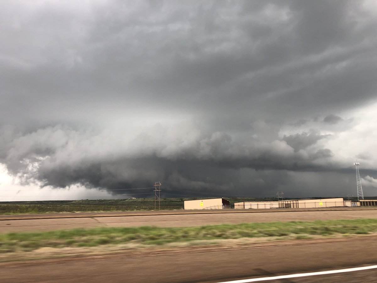
The May 7th severe weather event was, like all sizeable severe weather episodes, the culmination of multiple meteorological factors coming into place at the same time. In the days leading up to the event, rich moisture was brought northward from the Gulf of America, resulting in showers and thunderstorms on both May 5th and May 6th. On May 7th, an upper low moved into the Four Corners, causing a surface area of low pressure to develop across New Mexico. The Panhandles were on the east side of this area of low pressure, setting up winds out of the south and southeast which brought in additional moisture and warmed temperatures through the morning and afternoon hours. This escalation of both temperature and moisture gave the atmosphere increased energy for storms. Furthermore, the approach of the upper low led to an upsurge in wind speeds aloft out of the southwest. The difference between these southwesterly winds aloft and the southeasterly winds at the ground, known as wind shear, escalated through the daytime hours. Finally, a surface front, augmented by cold air rushing out of thunderstorms over Kansas very early Tuesday morning, pushed south into the Panhandles. This front stalled out and retrograded back to the north under the influence of those southeasterly surface winds. This stalled front would provide an additional focus for thunderstorm development.
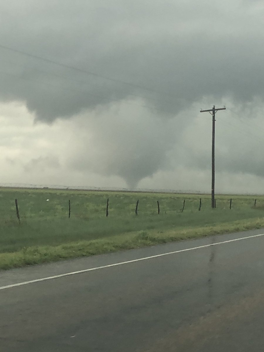
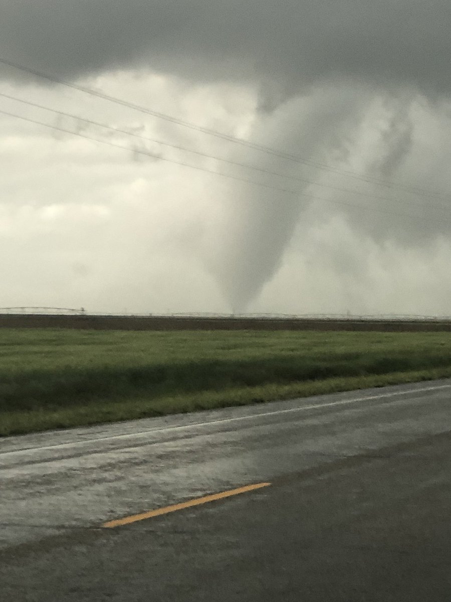
Strong storms began to fire around noon and quickly became severe, with the first severe thunderstorm warning issued at 12:33pm. The first report of severe weather, quarter size hail 5 miles south of Masterson, came in at 1:12pm. Storms began to increase in number after 1:00pm, becoming numerous after 2:00pm. The largest hail reports of the event were received at 2:02pm, when baseball size hail fell near Lake Meredith and Fritch. With wind shear increasing through the afternoon, a few of the storms became tornadic, with the first tornado touching down 9 miles south-southwest of Spearman at 3:42pm. Six subsequent tornadoes occurred, two associated with a particularly nasty supercell that spawned multiple tornadoes along a line from between Plainview and Hart northeast through Alanreed. The bulk of the storms pushed eastward into Oklahoma after 9:30pm, although a couple additional rounds formed behind them, which had a few cells become severe. The last of the thunderstorms shifted into western Oklahoma after 2:00am.
Tornadoes:
7 confirmed tornadoes touched down in the Texas Panhandle on May 7th. At this time, all tornadoes were rated EF0. It is important to note that the Enhanced Fujita scale is a damage scale - if a tornado encounters no sturdy well built structures, a low rating will be issued. Finally, it should be noted that a couple persistent tornado myths, that tornadoes cannot cross river valleys or that tornadoes cannot form in river valleys, were conclusively shown in this event to have no factual basis. The Canadian River Valley tornado formed and traveled entirely within the valley. The Wayside tornado crossed Palo Duro Canyon. If you think your town is protected because it is in a valley, on top of a hill, near a hill, in a small depression, etc., it is not. This, however, is no reason to live in fear - it only takes a few minutes to prepare.
|
Tornado #1 - Southeast of Spearman
Track Map 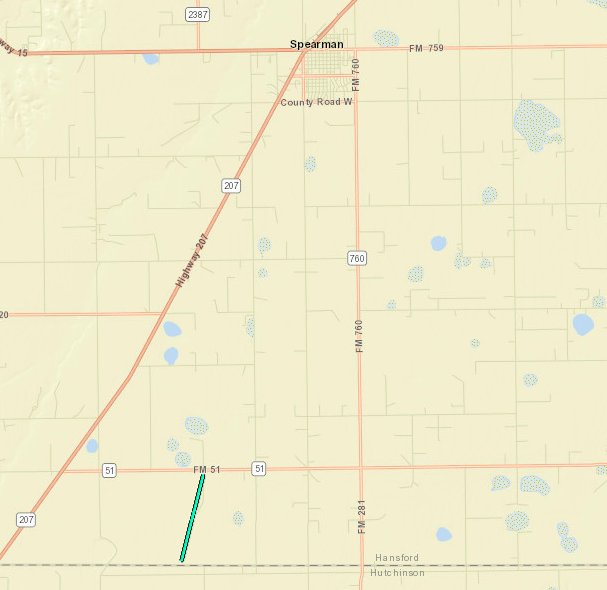  |
||||||||||||||||
|
Tornado #2 - Borger
Track Map - Look Northwest of the Airport 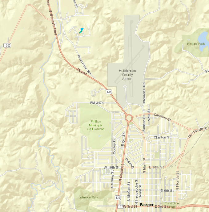 |
||||||||||||||||
|
Tornado #3 - North of Perryton
Track Map 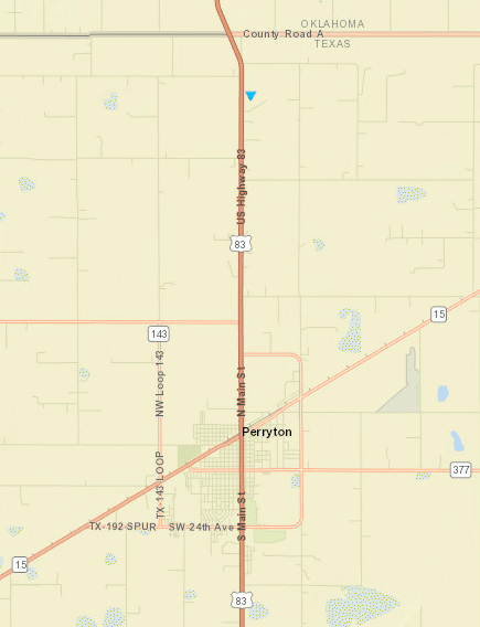 |
||||||||||||||||
|
Tornado #4 - Canadian River Valley
Track Map 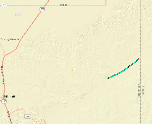 |
||||||||||||||||
|
Tornado #5 - Near Wayside (PRELIMINARY INFORMATION)
Track Map 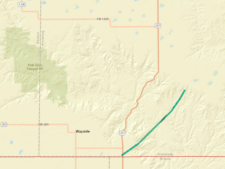 |
||||||||||||||||
|
Tornado #6 - Near Alanreed
Track Map 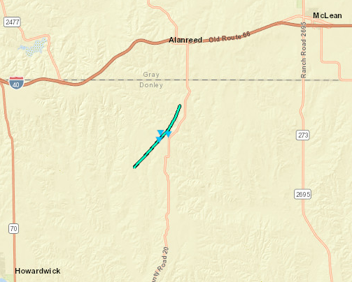 |
||||||||||||||||
|
Tornado #7 - West of Lipscomb
Track Map 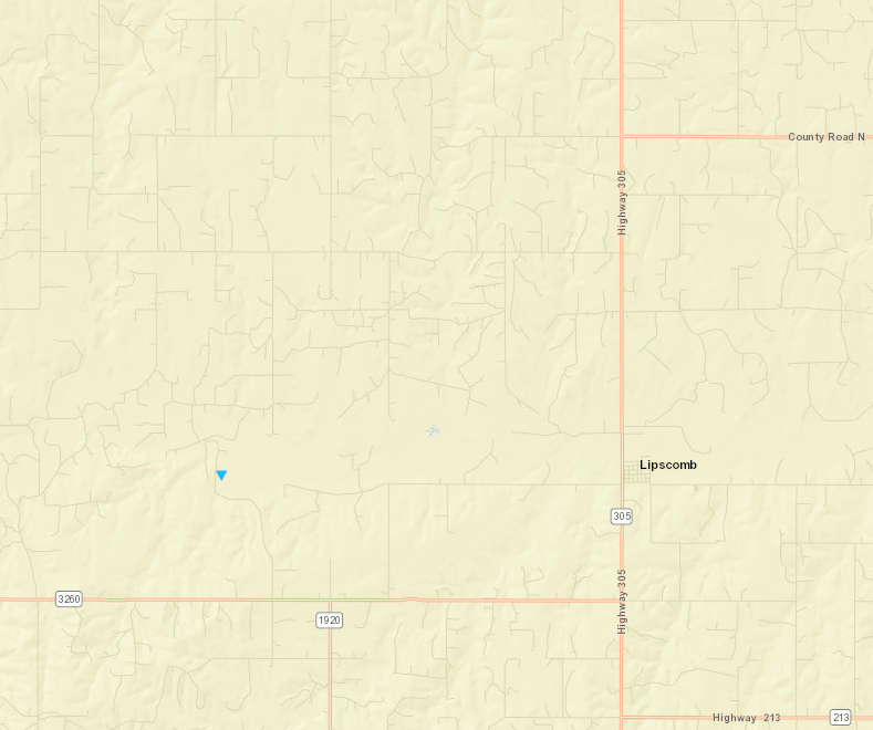 |
||||||||||||||||
The Enhanced Fujita (EF) Scale classifies tornadoes into the following categories:
| EF0 Weak 65-85 mph |
EF1 Moderate 86-110 mph |
EF2 Significant 111-135 mph |
EF3 Severe 136-165 mph |
EF4 Extreme 166-200 mph |
EF5 Catastrophic 200+ mph |
 |
|||||
Satellite
One minute temporal resolution data from GOES-16, fully operational since December 2017, provided forecasters with an additional tool to monitor the progress of the overall weather system that helped kick off this severe weather event, assess the relative strength of storms, and in many cases anticipate which were growing stronger before an increase in strength was fully apparent on radar. GOES-16 has multiple improvements over predecessor satellites that were useful during this event - higher spatial resolution, higher temporal resolution, lightning detection, additional water vapor channels, and additional infrared channels.
| Loop of mid-level water vapor satellite data. Thunderstorm development across the Panhandles and West Texas is apparent. Approximate location of upper low shown. (NASA/NOAA GOES-16) |
| Loop of infrared/visible "sandwich" satellite data with warnings. Image darkens as sun sets due to loss of visible data. (Satellite imagery: NASA/NOAA GOES-16. Warnings from NWS.) |
Photos & Video
Thanks to everyone who shared their photos with us! No guarantees it will end up on this page, but if you have a photo you'd like to share, send it to us on our Facebook page (facebook.com/nwsamarillo), our Twitter page (twitter.com/nwsamarillo), or our email (sr-ama.webmaster@noaa.gov) address.
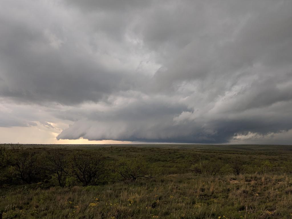 |
| Wall cloud northwest of Amarillo at 4:13pm (Alex Schueth) |
 |
| Tornado southwest of Spearman, Texas (Matt Maynard) |
 |
| Closer view of the tornado southwest of Spearman, Texas (Matt Maynard) |
 |
| Ground scraping wall cloud near Bishop Hills, Texas at 4:06pm (Mike Prendergast) |
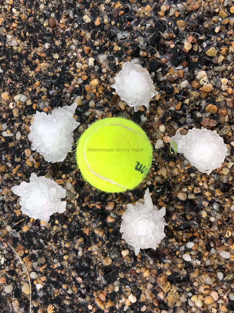 |
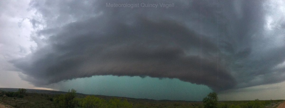
| Golf ball size hail 6 miles northwest of Fritch, Texas at 1:53pm (Quincy Vagell) |
 |
| Mesocyclone near Howardwick, Texas at 7:37pm (Quincy Vagell) |
| Caption (source) |
Radar
| Radar Reflectivity Loop of May 7th, 2019 Severe Weather Event. Image source: Iowa Environmental Mesonet. Radar and warnings from NWS. |
Storm Reports
Reports Map
.JPG) |
| Map of Preliminary Storm Reports Received on May 7th. (Map Source: Iowa Environmental Mesonet. Reports from NWS.) |
Table of Reports
Flash flood, hail, funnel cloud, and wind gust reports are listed here. For details on the tornadoes that occurred, see the 'Tornadoes' tab above.
| Report Time | County | Location | Event Type | Magnitude | Source | Latitude | Longitude | Remarks |
|---|---|---|---|---|---|---|---|---|
| 5/7/19 16:48 | HUTCHINSON | FRITCH | FLASH FLOOD | 0.00 | SOCIAL MEDIA | 35.64 | -101.60 | |
| 5/7/19 17:32 | POTTER | 9 N AMARILLO | FLASH FLOOD | 0.00 | DEPT OF HIGHWAYS | 35.33 | -101.83 | |
| 5/7/19 19:20 | CARSON | 1 W GROOM | FLASH FLOOD | 0.00 | AMATEUR RADIO | 35.20 | -101.12 | |
| 5/7/19 21:08 | POTTER | 1 NNE BUSHLAND | FLASH FLOOD | 0.00 | PUBLIC | 35.21 | -102.06 | STREET/ROAD FLOADING; STREET/ROAD CLOSED; VEHICLES STRANDED |
| 5/7/19 16:01 | POTTER | 1 N BUSHLAND | FUNNEL CLOUD | 0.00 | TRAINED SPOTTER | 35.20 | -102.06 | FUNNEL CLOUD TRYING TO TOUCH GROUND |
| 5/7/19 16:15 | OCHILTREE | 3 NW FARNSWORTH | FUNNEL CLOUD | 0.00 | STORM CHASER | 36.35 | -101.00 | LATE REPORT OF MULTIPLE BRIEF FUNNEL CLOUDS NEAR FARNSWORTH, TX. |
| 5/7/19 18:56 | LIPSCOMB | 7 W LIPSCOMB | FUNNEL CLOUD | 0.00 | STORM CHASER | 36.23 | -100.40 | FUNNEL CLOUD NORTHWEST OF LOCATION AND HALFWAY DOWN |
| 5/7/19 19:18 | LIPSCOMB | 3 SSE FOLLETT | FUNNEL CLOUD | 0.00 | TRAINED SPOTTER | 36.40 | -100.11 | LATE REPORT OF A FUNNEL CLOUD SOUTHEAST OF FOLLETT. CAME DOWN ABOUT HALF WAY TO THE GROUND AND THEN LIFTED. ONLY LASTED A FEW MINUTES |
| 5/7/19 13:12 | POTTER | 5 S MASTERSON | HAIL | 1.00 | TRAINED SPOTTER | 35.56 | -101.96 | |
| 5/7/19 13:36 | MOORE | 1 SSW DUMAS | HAIL | 1.00 | TRAINED SPOTTER | 35.85 | -101.97 | |
| 5/7/19 13:36 | MOORE | DUMAS | HAIL | 1.50 | LAW ENFORCEMENT | 35.86 | -101.96 | |
| 5/7/19 13:39 | MOORE | DUMAS | HAIL | 1.00 | BROADCAST MEDIA | 35.86 | -101.96 | |
| 5/7/19 13:53 | MOORE | 6 NW FRITCH | HAIL | 1.75 | SOCIAL MEDIA | 35.70 | -101.67 | NUMEROUS PING PONG TO GOLFBALL SIZE HAIL |
| 5/7/19 13:59 | MOORE | LAKE MEREDITH | HAIL | 1.75 | EMERGENCY MNGR | 35.65 | -101.66 | |
| 5/7/19 14:02 | HUTCHINSON | FRITCH | HAIL | 2.75 | SOCIAL MEDIA | 35.64 | -101.60 | HAIL BETWEEN GOLFBALL AND BASEBALL SIZE |
| 5/7/19 14:02 | MOORE | LAKE MEREDITH | HAIL | 2.75 | EMERGENCY MNGR | 35.65 | -101.66 | |
| 5/7/19 14:18 | POTTER | 9 SSE MASTERSON | HAIL | 1.00 | STORM CHASER | 35.51 | -101.91 | |
| 5/7/19 14:28 | POTTER | 10 SSE MASTERSON | HAIL | 1.00 | TRAINED SPOTTER | 35.50 | -101.90 | |
| 5/7/19 14:55 | HUTCHINSON | 4 N STINNETT | HAIL | 1.75 | TRAINED SPOTTER | 35.88 | -101.45 | |
| 5/7/19 15:00 | POTTER | VALLEY DE ORO | HAIL | 1.00 | BROADCAST MEDIA | 35.45 | -102.11 | |
| 5/7/19 15:15 | HUTCHINSON | 3 S PRINGLE | HAIL | 1.50 | TRAINED SPOTTER | 35.91 | -101.46 | |
| 5/7/19 15:18 | TEXAS | 1 NNE ADAMS | HAIL | 1.00 | TRAINED SPOTTER | 36.76 | -101.07 | LATE REPORT OF DIME TO QUARTER SIZE HAIL THAT FELL FOR A FEW MINUTES. |
| 5/7/19 15:25 | POTTER | 7 ENE VALLEY DE ORO | HAIL | 1.75 | BROADCAST MEDIA | 35.50 | -101.99 | |
| 5/7/19 15:34 | DEAF SMITH | 8 SSE WILDORADO | HAIL | 1.75 | TRAINED SPOTTER | 35.11 | -102.19 | |
| 5/7/19 15:36 | MOORE | 7 W DUMAS | HAIL | 1.00 | LAW ENFORCEMENT | 35.86 | -102.09 | |
| 5/7/19 15:57 | BEAVER | TURPIN | HAIL | 1.00 | TRAINED SPOTTER | 36.86 | -100.88 | LATE REPORT OF HEAVY RAINFALL AND HAIL UP TO QUARTER SIZE. |
| 5/7/19 15:59 | POTTER | 6 NNE BUSHLAND | HAIL | 2.50 | TRAINED SPOTTER | 35.27 | -102.04 | LATE REPORT OF TENNIS BALL SIZE HAIL ALONG HIGHWAY 1061 NORTH OF BUSHLAND. |
| 5/7/19 15:59 | POTTER | 6 NNE BUSHLAND | HAIL | 2.50 | TRAINED SPOTTER | 35.27 | -102.04 | LATE REPORT OF TENNIS BALL SIZE HAIL ALONG HIGHWAY 1061 NORTH OF BUSHLAND. SEVERAL CARS HAD WINDSHIELDS BUSTED OUT. |
| 5/7/19 16:01 | OCHILTREE | 3 NNW WAKA | HAIL | 1.00 | PUBLIC | 36.32 | -101.06 | LATE REPORT OF HEAVY RAINFALL AND HAIL UP TO QUARTERS. |
| 5/7/19 16:07 | POTTER | 6 NNE BUSHLAND | HAIL | 2.50 | STORM CHASER | 35.27 | -102.03 | |
| 5/7/19 16:15 | HUTCHINSON | FRITCH | HAIL | 0.75 | TRAINED SPOTTER | 35.64 | -101.60 | |
| 5/7/19 16:20 | RANDALL | 2 WNW CANYON | HAIL | 0.75 | NWS EMPLOYEE | 34.99 | -101.95 | |
| 5/7/19 16:23 | HUTCHINSON | FRITCH | HAIL | 1.25 | SOCIAL MEDIA | 35.64 | -101.60 | QUARTER TO HALF DOLLAR SIZE HAIL NEAR FRITCH. |
| 5/7/19 16:28 | HUTCHINSON | 3 NW SANFORD | HAIL | 1.00 | TRAINED SPOTTER | 35.73 | -101.57 | LOTS OF NICKEL TO QUARTER SIZE HAIL |
| 5/7/19 16:37 | RANDALL | 6 N CANYON | HAIL | 1.00 | PUBLIC | 35.06 | -101.92 | |
| 5/7/19 16:37 | RANDALL | 6 SW AMARILLO | HAIL | 1.00 | PUBLIC | 35.14 | -101.89 | |
| 5/7/19 16:50 | HUTCHINSON | 3 N BORGER | HAIL | 1.75 | TRAINED SPOTTER | 35.71 | -101.41 | LATE REPORT OF GOLF BALL SIZE HAIL. HAIL DAMAGE INCLUDED BROKEN WINDOWS, DENTED CARS, FENCE DAMAGE AND ROOF DAMAGE. |
| 5/7/19 17:11 | POTTER | 6 N BUSHLAND | HAIL | 1.25 | SOCIAL MEDIA | 35.28 | -102.05 | |
| 5/7/19 17:44 | HUTCHINSON | 4 WSW BORGER | HAIL | 0.75 | TRAINED SPOTTER | 35.63 | -101.46 | LATE REPORT OF DIME SIZE HAIL. |
| 5/7/19 18:04 | WHEELER | 1 ENE BRISCOE | HAIL | 1.00 | PUBLIC | 35.59 | -100.27 | LATE REPORT OF QUARTER SIZE HAIL. |
| 5/7/19 18:20 | ARMSTRONG | 6 E WAYSIDE | HAIL | 1.75 | TRAINED SPOTTER | 34.79 | -101.44 | |
| 5/7/19 18:30 | ARMSTRONG | 6 E WAYSIDE | HAIL | 1.75 | TRAINED SPOTTER | 34.79 | -101.44 | |
| 5/7/19 18:41 | LIPSCOMB | 3 ESE LIPSCOMB | HAIL | 1.25 | TRAINED SPOTTER | 36.22 | -100.22 | LATE REPORT OF HALF DOLLAR SIZE HAIL. |
| 5/7/19 19:42 | WHEELER | 1 N SHAMROCK | HAIL | 1.00 | PUBLIC | 35.23 | -100.25 | |
| 5/7/19 20:52 | POTTER | AMARILLO | HAIL | 0.88 | SOCIAL MEDIA | 35.20 | -101.82 | PENNY SIZE HAIL WITH A FEW NICKELS OFF OF GEM LAKE ROAD IN AMARILLO. |
| 5/7/19 20:53 | POTTER | 5 WNW AMARILLO | HAIL | 1.00 | TRAINED SPOTTER | 35.23 | -101.90 | |
| 5/7/19 20:03 | GRAY | 4 W MCLEAN | TSTM WND GST | 60.00 | TRAINED SPOTTER | 35.23 | -100.67 |
Rain Reports
On top of generating severe weather, the storms on May 7th were prolific rain producers, with amounts of up to 6 inches of rainfall falling. Highest amounts were seen northwest of Lake Meredith and across eastern Wheeler and Collingsworth Counties. Additionally, a few locations recorded flash flooding. See the 'Storm Reports' tab above for more information on flash flooding.
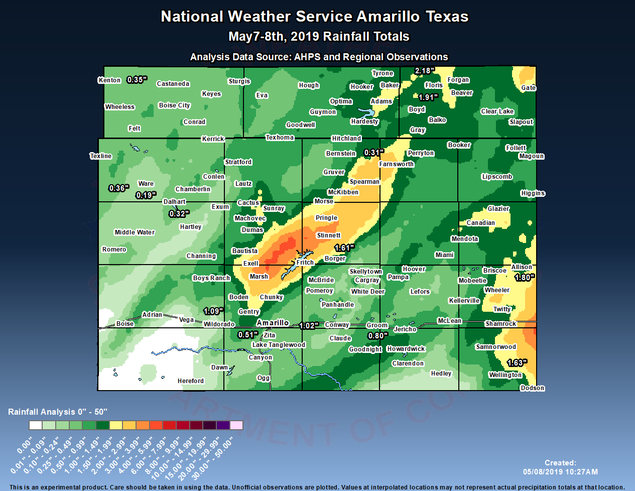 |
| Estimated rainfall using a combination of point rainfall report and AHPS radar-based estimates. (Rainfall data: NWS. Map made using GAZPACHO.) |
 |
Media use of NWS Web News Stories is encouraged! Please acknowledge the NWS as the source of any news information accessed from this site. |
|

