National Weather Service United States Department of Commerce

Snow Across the Great Lakes, Central Appalachians, and Northeast; Unsettled Weather in the West

Light to moderate snow will continue into Saturday over the Great Lakes, Central Appalachians, and Northeast. This weekend into next week, a series of atmospheric rivers will bring gusty winds, periods of heavy rain, and mountain snow to northern California and the Pacific Northwest. Colder temperatures are in store for the weekend from the Great Lakes to East Coast. Read More >

Click a location below for detailed forecast.

Last Map Update: Sat, Dec 21, 2024 at 9:10:40 am CST

There are no watches, warnings, or advisories at this time.

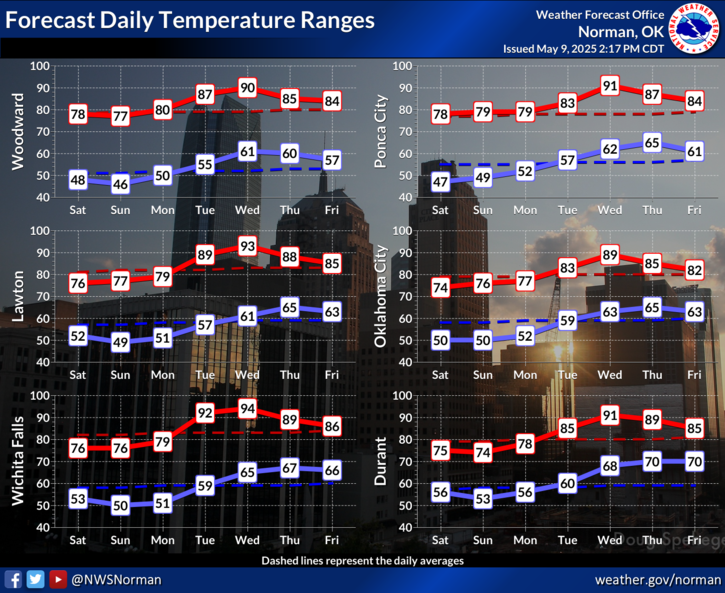
Warmer normal temperatures are expected on Saturday as winds transition from the south.
Our next weather system will be coming through late Monday into Tuesday bringing a cold front through. Rain chances will be generally near and east of the I-35 corridor with a few storms possible across southeast Oklahoma. A cooler milder air mass will come in behind the cold front resulting in colder Tuesday night into Christmas morning after which temperatures will be rapidly warming.
Unseasonable warmth and dry conditions are expected on Christmas Day across the area.
Dry weather is expected through the weekend before chances for showers and storms arrive after sunset on Monday (mainly near and east of I-35.

 Current Weather Observations...
Location Time
(CST)
Weather Vsby.
(SM)
Temp.
(ºF)
Dewpt.
(ºF)
Hum.
(%)
Wind
(mph)
Wind Chill / Heat Index
(ºF)
Pres.
(in)
Oklahoma City, OK08:52Clear10312166SSE 922 [WC]30.37
Norman, OK08:45Clear10301963SE 722 [WC]30.36
Stillwater, OK08:53Clear10302065ESE 921 [WC]30.41
Lawton, OK08:53Clear10312475SSE 823 [WC]30.37
Wichita Falls, TX08:52Clear10312475SE 723 [WC]30.38
Ponca City, OK08:53Clear10302065ESE 722 [WC]30.42
Enid, OK08:55Clear10292068ESE 1019 [WC]30.35
Alva, OK08:35Lightning Observed10211992NE 811 [WC]30.37
Woodward, OK08:30Clear10231779SE 516 [WC]30.34
Gage, OK08:53Clear10251977SSE 3-30.31
Watonga, OK08:35Clear10262075NE 917 [WC]30.39
Clinton, OK08:53Clear10312268SSE 1022 [WC]30.31
Weatherford, OK08:55Clear10302167SE 623 [WC]30.34
Altus, OK08:55Clear10332469SE 1721 [WC]30.33
Frederick, OK08:53Clear10322472SE 1222 [WC]30.33
Ardmore, OK08:50Clear10302686CALM-30.43
Ada, OK08:55Clear10322474SE 725 [WC]30.39

Local Weather History For December 21st...
In 2013, a significant winter storm affected Oklahoma and western
north Texas from December 20th to the 22nd. This storm brought
significant amounts of ice to much of central and southwest Oklahoma,
while dumping up to six inches of snow across northwest Oklahoma. Up
to three-quarters of an inch of ice accumulated over Canadian and
Caddo counties, around Fort Cobb and El Reno. The rest of central and
southwest Oklahoma, and adjacent parts of north Texas, saw between
one-quarter and one-half inch. The ice brought down numerous tree
limbs and resulted in brief power disruptions. The highest snow
totals were seen around Laverne, Rosston, and Buffalo.

Text Product Selector (Selected product opens in current window)
Weather Observations Area Forecast Discussion Air Quality Forecasts Hydrology Information Frequently Asked Questions Social Media
Observations Discussion Air Quality Hydrology FAQ Social Media
 
Submit a Storm Report Graphical Weather Forecasts Aviation Weather Forecasts Climate Data Storm Data Weather Radio Information
Storm Reports Gridded Forecast Aviation Climate Storm Data Weather Radio  
 
Satellite Information Hourly Weather Forecast Fire Weather Information Past Weather Events StormReady Skywarn/Storm Spotters
Satellite Hourly Forecast Fire Weather Past Events StormReady Storm Spotters