| April 3, 2015 Severe Storms & Williamson County Tornado |
 |
| Overview |
| After an unusual lack of thunderstorms and severe weather across Middle Tennessee during the first three months of 2015, a widespread severe weather event affected the Mid State during the afternoon and evening hours on Friday, April 3, 2015. A broken line of severe thunderstorms developed along a cold front across western Tennessee, which then moved across Middle Tennessee before exiting the region before midnight. These storms brought widespread damaging straight-line winds to the southeast half of Middle Tennessee, along with several reports of large hail up to 1 inch in diameter. In addition, one EF0 tornado briefly touched down in Williamson County west of Franklin. |
| Reports & Outlooks | |||
| SPC Storm Reports | SPC Event Archive | Local Storm Reports | |
| EF0 Williamson County Tornado | |
| Counties: | Williamson |
| Time: | 522-530 PM |
| Wind Speed Estimate: | 80 MPH |
| Damage Path Length: | 5.6 miles |
| Damage Path Width: | 75 yards |
| Description: A small EF0 tornado intermittently touched down in the Kingfield community of western Williamson County, then moved eastward north of Leipers Fork before lifting west of Franklin. A carport was blown down a hillside on Hargrove Road, and a couple of homes and outbuildings received minor roof damage on Wilkins Branch Road. A few trees were blown down along Old Highway 96 and in the hills south of Parker Branch Road. The worst damage occurred near the intersection of Parker Branch Road and Old Hillsboro Road, where two homes had considerable roof damage and numerous trees were snapped and uprooted. A few more trees were blown down on Boxley Valley Road, McMillan Road, and Boxley View Lane before the tornado lifted. |
|
NWS Storm Survey Photos:     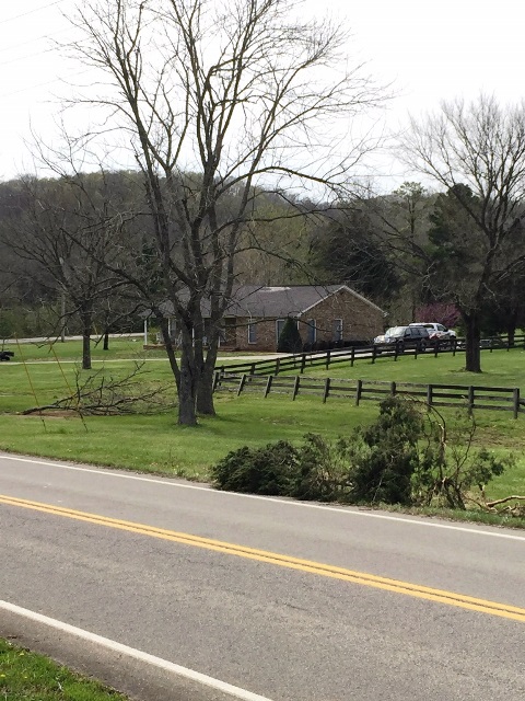                |
|
TBNA Radar Storm Relative Velocity Loop: |
|
| McMinnville Downburst | |
| Counties: | Cannon/Warren/Van Buren |
| Time: | 630-700 PM |
| Wind Speed Estimate: | 60-80 MPH |
| Description: The supercell thunderstorm that spawned the earlier tornado in Williamson County turned into a bow echo and produced a large downburst that affected much of Cannon, Warren, and Van Buren counties with widespread 60 to 80 mph winds. The worst damage was reported on the north and northeast sides of McMinnville, where a warehouse building was destroyed and roof blown off a vet clinic on Sparta Highway, and numerous trees and power lines blown down. |
|
OHX Radar (GR2Analyst) Reflectivity/Base Velocity Loop: |
|


 Follow us on YouTube