National Weather Service United States Department of Commerce
April 27-28, 2013 Flash Flooding & Severe Weather

Rainfall Map


Overview
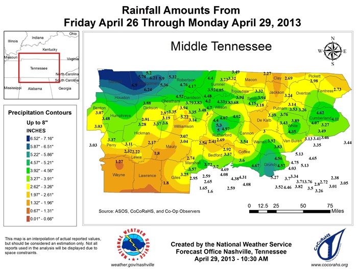
Numerous showers and thunderstorms developed across Middle Tennessee early on April 27 and continued into the afternoon hours as a weak warm frontal boundary was draped across the region. Some flooding was reported in the Nashville metro area. Additional showers and thunderstorms formed later in the day on April 27 and continued into April 28. Training thunderstorms caused widespread flash flooding. The worst flash flooding was across Houston, Stewart, and Montgomery counties where many homes and businesses were flooded, numerous roads were washed out, and several people were rescued from the flood waters. Several reports of wind damage and large hail were also received. Total damage from the flash flooding alone was estimated at over 15 million dollars.


Reports & Outlooks
HPC QPF Local Storm Reports Public Information Statements SPC Storm Reports


Stewart County Flash Flood
Time: 4/27/2013 at 700 pm to 4/28/2013 at 400am
Fatalities: 0
Injuries 1

Damage:

Repeated development of thunderstorms across Stewart County resulted in 5 to 7 inches of rain falling during the evening hours on April 17. Disastrous flash flooding resulted from the heavy rainfall, with numerous roadways washed out or underwater, dozens of homes flooded, and five water rescues of people in vehicles. The worst flooding occurred in the Indian Mound and Carlisle communities, where 20 people were trapped by flood waters. One man suffered minor injuries after driving off a washed out section of Leatherwood Road, with his car falling ten feet down into a ravine. Other flooded and washed out roadways across Stewart County included Taylor's Chapel Road, Rorie Hollow, North Cross Creek Road, Big Rock Road, Joiner Hollow Road, Robertson Hill Road, Wildlife Road, Norris Handcock Road, Centerpoint Road, Indian Mound Road, and Highway 49. In total, 25 homes were reported destroyed, 25 homes suffered major damage, and 20 homes had minor damage. Total damage was estimated around 10 million dollars.

Photos (courtesy of Tennessee Emergency Management Agency):

Road Out Road Out Aerial View of Road Out Home Damage River flooding


Houston County Flash Flood
Time: 4/27/2013 at 800 pm to 4/28/2013 at 300 am
Fatalities: 0
Injuries 0

Damage:

Repeated development of thunderstorms across Houston County resulted in 5 to 7 inches of rain falling during the evening hours on April 27. Major flash flooding resulted from the heavy rainfall, with several homes and businesses damaged along with numerous roadways flooded. A house off Midway Drive was significantly damaged by the flood. Erin First Baptist Church, Houston County Middle School, and Sudden Service were some of the non-residential buildings that flooded. Fourteen residents were evacuated from the Oak Brook Retirement Home. Roads that were flooded, closed, or suffered flood damage in Erin included Main Street, Mobley Lane, Mitchell Road, Spring Street, Metcalf Drive, Front Street, Denmark Road, Hill Street Bridge, Tank Hill Road, Maple Street, Highway 149 and Highway 147. Other roadways across the county that were flooded or received flood damage included Highway 147 in McKinnon, Dancer Branch Road, Herman Clark Road, Moore Branch Road, and Kaiser Ridge Road. Total damage was estimated around 4 million dollars.


Montgomery County Flash Flood
Time: 4/27/2013 at 800 pm to 4/28/2013 at 400 am
Fatalities: 0
Injuries 0

Damage:

Repeated development of thunderstorms across Montgomery County resulted in 5 to 7 inches of rain falling during the evening hours on April 27 into the early morning hours on April 28. Significant flash flooding resulted from the heavy rainfall, with numerous roadways flooded, impassable, and closed across the county. Flooded roadways included Trenton Road, Highway 76 at Port Royal Road, Madison Street in Clarksville, and many other secondary and low-lying roadways. Over the next several days following the flash flood, a few large sinkholes formed on some roadways, such as Fort Campbell Boulevard in Clarksville, which resulted in additional road closures. Total damage was estimated around 1 million dollars.


Davidson County Flash Flood
Time: 4/27/2013 at 1230 pm to 200 pm
4/27/2013 at 800 pm to 4/28/2013 at 1000 am
Fatalities: 0
Injuries 0

Damage:

Considerable flooding affected the Antioch area of southeast Davidson County on Saturday afternoon April 27 after radar estimates indicated 2 to 3 inches of rain had fallen since midnight. Locations along Mill Creek saw the most substantial flooding, such as Culbertson Road which was impassable due to high water, the Lighthouse Christian Ball Park along Blue Hole Road at I-24, and the old Family Fun Center on Bell Road at I-24.

Moderate rainfall of 1 to 2 inches during the morning of April 27 was followed by heavy thunderstorms that produced an additional 2 to 4 inches of rainfall during the evening and into the early morning hours on April 28. The result was widespread flash flooding of roadways and a few homes across Davidson County, with numerous water rescues from people trapped in vehicles. Several homes flooded along Dry Creek in Goodlettsville on Jannett Avenue at Monticello Avenue. Roadways that were flooded included Bear Hollow Road, Porter Road, Riverside Drive, and Eatons Creek Road near Old Hickory Boulevard.

Flood waters continued to rise in rivers and creeks across southern Davidson County into the morning hours on April 28 after flash flooding that occurred the previous night. The parking lot of the Harpeth Valley Golf Center on Old Hickory Pike in Bellevue was covered by one and a half feet of flood waters from the Harpeth River. Other areas such as locations along Mill Creek in Antioch also continued to see flooding.


Sumner County Flash Flood
Time: 4/27/2013 at 1100 pm to 4/28/2013 at 300 am
Fatalities: 0
Injuries 0

Damage:

Moderate rainfall of 1 to 2 inches during the morning of April 27 was followed by heavy thunderstorms that produced an additional 2 to 4 inches of rainfall during the evening into the early morning hours on April 28. The result was widespread flash flooding of roadways across Sumner County, with numerous water rescues from people trapped in vehicles. Four water rescues on individuals from vehicles took place on Twelve Stones Crossing near Moss Wright Park in Goodlettsville, Saundersville Road at Wessington Place Road in Hendersonville, Newton Lane at Steam Plant Road in Gallatin, and Old Highway 25 at Lackey Street in Castalian Springs. Other roadways that were flooded included roads near Drakes Creek Park in Hendersonville.


Wilson County Flash Flood
Time: 4/27/2013 at 1100 pm to 4/28/2013 at 300 am
Fatalities: 0
Injuries 0

Damage:

Moderate rainfall of 1 to 2 inches during the morning of April 27 was followed by heavy thunderstorms that produced an additional 2 to 4 inches of rainfall during the evening and into the early morning hours on April 28. The result was widespread flash flooding of roadways across Wilson County. Roadways that were flooded and closed in Mount Juliet included Old Lebanon Dirt Road at Kelsey Glen Drive and Nonaville Road, while roadways that were flooded and closed in Lebanon included Lebanon Road at Main Street, Lebanon Road at Maplewood Road, and Coles Ferry Road at Academy Road. Many other roadways throughout the county were also reportedly flooded.


Rutherford County Flash Flood
Time: 4/27/2013 at 1230 pm to 200 pm
4/28/2013 at 1200 am to 400 am
Fatalities: 0
Injuries 0

Damage:

Considerable flooding affected the La Vergne area of northwest Rutherford County on Saturday afternoon April 27 after radar estimates indicated 2 to 3 inches of rain had fallen since midnight. Locations along Mill Creek saw the most substantial flooding, such as Deer Drive where one home was flooded. Other homes on Taylor Drive and Apple Drive had water approach but not flood them.

Moderate rainfall of 1 to 2 inches during the morning of April 27 was followed by heavy thunderstorms that produced an additional 2 to 4 inches of rainfall during the evening and into the early morning hours on April 28. The result was widespread flash flooding of roadways and some homes across Rutherford County. Two homes were flooded and evacuated on Old Nashville Highway at Jefferson Pike in LaVergne, and more homes were flooded and evacuated on Rocky Ford Road at Rocky Fork Almaville Road in Almaville. Roadways were also flooded requiring the evacuation of homes near the I-24 and Highway 840 interchange in Murfreesboro, including Hardwood Drive, Nandina Court, and Camborne Circle.


Williamson County Flash Flood
Time: 4/27/2013 at 1230 pm to 200 pm
4/27/2013 at 1100 pm to 4/28/2013 at 300 am
Fatalities: 0
Injuries 0

Damage:

Considerable flooding affected the Brentwood area of northeast Williamson County on Saturday afternoon April 27 after radar estimates indicated 2 to 3 inches of rain had fallen since midnight. Locations along Owl Creek saw the most substantial flooding, with Waller Road reportedly underwater. Several driveways were also covered by flood waters along Waller Road.

Moderate rainfall of 1 to 2 inches during the morning of April 27 was followed by heavy thunderstorms that produced an additional 2 to 4 inches of rainfall during the evening and into the early morning hours on April 28. The result was widespread flash flooding of roadways across Williamson County. Roadways that were flooded in Franklin included Carothers Road at Williamson Medical Center, Alpha Drive, Lewisburg Pike, Oxford Glen Drive at McEwen Road, Sycamore Road at Liberty Road, and the Breezeway subdivision near Clovercroft Elementary School. Several roadways were also flooded in Nolensville, including Nolensville Road.