
| February 29, 2012 Tornadoes | ||||||||
| # | Counties | Rating | Time (CST) | Length (miles) | Width (yards) | Fatalities | Injuries | |
| 1 | DeKalb/White | EF1 | 1546 | 12.08 | 200 | 1 | 0 | |
| 2 | White | EF0 | 1604 | 2.16 | 50 | 0 | 0 | |
| 3 | Cumberland | EF2 | 1630 | 9.51 | 1000 | 2 | 7 | |
| Reports & Outlooks | |||
| SPC Outlooks | SPC Storm Reports | SPC Event Archive | |
| Public Information Statements | Local Storm Reports | SPC 2012 Killer Tornadoes | |
| Overview | |
| A strong upper level trough of low pressure moved across the Central Plains states on February 28, 2012, then spread eastward into the Ohio and Tennessee Valleys on February 29. An associated intense surface area of low pressure as deep as 987 mb moved northeastward from Colorado and through the Great Lakes, dragging a strong cold front rapidly across the Plains states into Middle Tennessee by the afternoon of the 29th. Scattered thunderstorms that developed ahead of the front produced numerous tornadoes across Kansas, Missouri, Illinois, Indiana, and Kentucky from late afternoon on February 28 through the night into February 29, resulting in several fatalities and dozens of injuries. As the front moved into Middle Tennessee during the afternoon, strong wind shear aloft with winds as high as 170 mph around 35000 feet above the ground, along with unusually warm temperatures in the upper 60s and lower 70s at the surface, combined to produce additional scattered showers and thunderstorms. Although these thunderstorms remained weak west of the I-65 corridor, the combination of strong wind shear and moderate instability led to some of the thunderstorms becoming supercells east of I-65 to the Cumberland Plateau region, resulting in 4 tornadoes and several reports of large hail and wind damage. The tornadoes combined caused millions of dollars in damage, 3 fatalities, and 7 injuries in the Mid State. |
| EF1 DeKalb/White County Tornado | |
| Counties: | DeKalb/White |
| Time: | 3:26 PM CST |
| EF Scale: | EF1 |
| Wind Speed Estimate: | 95 MPH |
| Damage Path Length: | 12.08 Miles |
| Damage Path Width: | 200 Yards |
| Start Point: | 35.97/-85.85 |
| End Point: | 36.02/-85.59 |
| Fatalities: | 1 |
| Injuries | 0 |
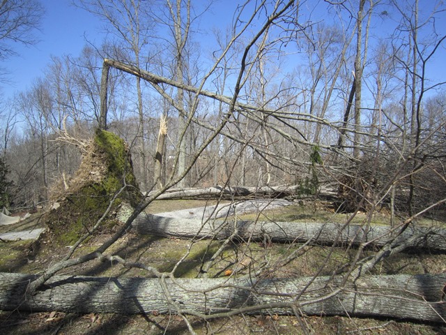
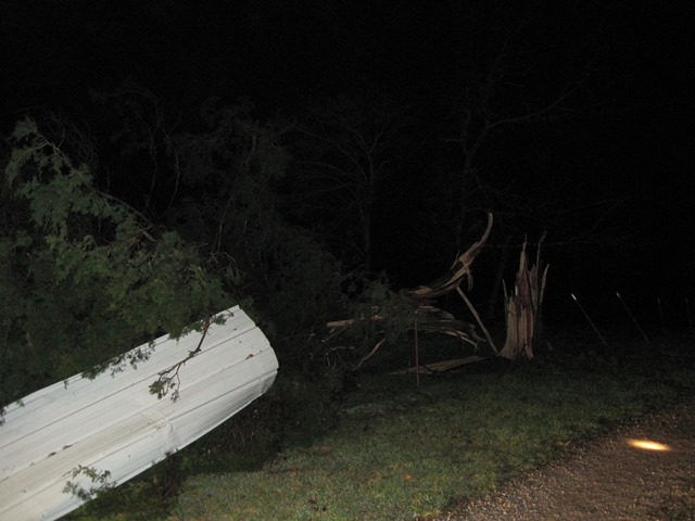
| Storm Data: An EF1 tornado with maximum wind speeds around 95 mph touched down about 1 mile northwest of Smithville along Highway 83, then tracked rapidly east-northeast across Center Hill Lake before ending in western White County about 7 miles northwest of Sparta. A barn was damaged near the beginning of the path, with sheet metal blown across fields and into power lines. Scattered trees were snapped or uprooted and some minor damage to homes occurred on the north side of Smithville as the tornado traveled generally along and just south of Highway 83 and Smithville Highway. A small warehouse-type building was destroyed at Smithville Highway and Pine Grove Road with debris thrown northward into fields. The roof of a barn was blown off and a few homes suffered minor roof damage at Holiday Haven Road and Scott Acres Road. The tornado increased in intensity as it moved along Alpine Drive, with hundreds of trees snapped or uprooted. One home on stilts was knocked down a hillside and destroyed, resulting in one fatality. The EF1 tornado moved out of DeKalb County into White County near Twilight Lane. A mobile home was damaged and a church steeple was blown off along Browntown Road near Wildcat Road, and two nearby outbuildings suffered roof damage. The roof of a barn was blown off southwest of the Browntown Road and Austin Road intersection, with debris blown for nearly one quarter mile across fields. A nearby home suffered minor roof damage. The tornado lifted just prior to reaching Austin Road. |
|
|
DeKalb County NWS Storm Survey Photos: |
|
White County NWS Storm Survey Photos:        |
|
| EF0 White County Tornado | |
| Counties: | White |
| Time: | 4:04 PM CST |
| EF Scale: | EF0 |
| Wind Speed Estimate: | 85 MPH |
| Damage Path Length: | 2.16 Miles |
| Damage Path Width: | 50 Yards |
| Start Point: | 36.02/-85.53 |
| End Point: | 36.03/-85.49 |
| Fatalities: | 0 |
| Injuries | 0 |
| Storm Data: An EF0 tornado with maximum wind speeds around 85 mph touched down near the Macedonia community northwest of Sparta, then moved rapidly eastward across Highway 111 before ending east of Walnut Grove Road. A home and barn suffered roof damage on Linville Road, and several trees were snapped or uprooted along the path. |
|
|
White County Photos (courtesy of White County Emergency Management): |
|
| EF2 Cumberland County Tornado | |
| Counties: | Cumberland |
| Time: | 4:30 PM CST |
| EF Scale: | EF2 |
| Wind Speed Estimate: | 125 MPH |
| Damage Path Length: | 9.51 Miles |
| Damage Path Width: | 1000 Yards |
| Start Point: | 36.09/-85.11 |
| End Point: | 36.13/-84.95 |
| Fatalities: | 2 |
| Injuries | 7 |
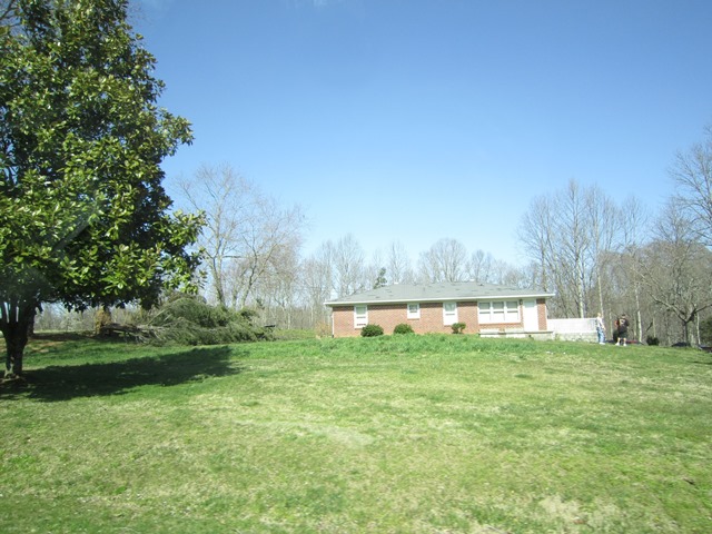
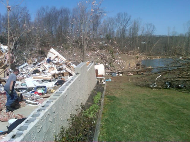
| Storm Data: An EF2 tornado with maximum wind speeds around 125 mph touched down along Castro-Pugh Road just north of Plateau Road in northern Cumberland County. Intermittent damage continued to the east-northeast for approximately 1 mile before the damage became continuous along Clear Creek Road. Hundreds of trees were uprooted and snapped and a home suffered roof damage in this area. The tornado continued east-northeast and reached EF2 intensity in the Rinnie community along Highway 127. A brick home slid off its foundation and was completely destroyed, killing one woman, and another nearby home lost its entire roof. A double wide mobile home along Hollow Road was also completely destroyed, killing another woman, with debris tossed hundreds of yards. At least a thousand trees were uprooted or snapped around this location. With the addition of new aerial imagery made available in Spring, 2013 the path has been extended over 3 additional miles and the path width widened to over 1/2 mile. There is clear evidence of tornadic damage extending well east beyond the original path ending point. |
|
|
Cumberland County NWS Storm Survey Photos: |
|


 Follow us on YouTube