
| Tornado Statistics | ||||||||
| # | Counties | Rating | Time (CST) | Length (miles) | Width (yards) | Fatalities | Injuries | |
| 1 | Dickson | EF1 | 0956 | 1.60 | 20 | 0 | 0 | |
| 2 | Lawrence/Giles | EF3 | 1102 | 17.10 | 100 | 0 | 1 | |
| 3 | Marshall | EF0 | 1140 | 0.10 | 10 | 0 | 0 | |
| 4 | Bedford | EF2 | 1211 | 8.77 | 200 | 0 | 0 | |
| 5 | Coffee | EF0 | 1230 | 0.18 | 20 | 0 | 0 | |
| 6 | Warren | EF1 | 1242 | 14.96 | 250 | 0 | 0 | |
| 7 | White | EF1 | 1320 | 1.75 | 800 | 0 | 0 | |
| Reports & Outlooks | |||
| SPC Storm Reports | SPC Day 1 Outlook | SPC Event Archive | Public Information Statements |
| EF1 Dickson County Tornado | |
| Counties: | Dickson |
| Time: | 9:56 AM CST |
| EF Scale: | EF0 |
| Damage Path Length: | 1.60 miles |
| Damage Path Width: | 20 yards |
| Fatalities: | 0 |
| Injuries | 0 |
| Damage: STORM DATA: EF1 tornado flattened two barns, trees were snapped and uprooted, and outbuilding was destroyed. A 6 feet by 10 feet section of vinyl siding came off a house. Damage was in the Jones Creek Road and Rock Church Road areas. SHAMBURGER (2015): The time path of this tornado was adjusted based on radar data and the narrative in Storm Data. |
|
| EF3 Lawrence/Giles County Tornado | ||
| Counties: | Lawrence/Giles | |
| Time: | 11:02 AM CST | |
| EF Scale: | EF3 | |
| Damage Path Length: | 17.10 miles | |
| Damage Path Width: | 100 yards | |
| Fatalities: | 0 | |
| Injuries: | 1 | |
| Damage: STORM DATA (Lawrence County): Many homes had roof damage especially on Coffee McGee Rd. An outbuilding was damaged on Crawfish Rd. Trees and utility poles were down along U.S. Highway 64 or Waynesboro Highway. Trees were down in Mt. Ararat Cemetery. The worst damage was a downed TVA electrical transmission tower east of U.S. Highway 43 on Hagan Rd. Metal debris was flung up and got stuck about a hundred feet above the ground in an electrical transmission tower. Numerous trees were snapped and uprooted. A newspaper article stated 56 homes had damage, with 12 homes being complete losses, which were mainly mobile homes. There was one minor injury. STORM DATA (Giles County): A low end EF3 tornado hit northwest Giles County near Liberty Hill. This was part of the same storm complex that hit Lawrence County. Numerous trees were snapped and uprooted. Many homes had roof damage. The hardest hit area was along Rhea Branch Rd. One residential home was completely leveled. Major damage occurred to the back of the Liberty Hill Baptist Church. A newspaper article stated that 8 homes were completely destroyed, and 30 other homes had serious damage. SHAMBURGER (2015): NCDC and Storm Data erroneously list the F3 tornado in Lawrence County and the F3 tornado in Giles County as separate tornadoes, when radar data and the damage path on Google Earth imagery clearly indicates they were the same tornado. Therefore, these two segments were combined in this entry. with the time, path length, and location of this tornado corrected based on radar data, the narratives in Storm Data, and the damage path on Google Earth aerial imagery. |
||
NWS Storm Survey Photos:                                             |
||
| EF0 Marshall County Tornado | |
| Counties: | Marshall |
| Time: | 11:40 AM CST |
| EF Scale: | EF0 |
| Damage Path Length: | 0.10 miles |
| Damage Path Width: | 10 yards |
| Fatalities: | 0 |
| Injuries | 0 |
| Damage: STORM DATA: A helicopter crew reported a tornado at the intersection of Highway 373 and Interstate 65. A NWS employee reported just a few trees were down. SHAMBURGER (2015): The location of this tornado was adjusted based on the narrative in Storm Data. In addition, the highway name intersecting with I-65 is incorrectly labeled in NCDC and Storm Data as Highway 343, which is in east Tennessee, instead of Highway 373, which is in Marshall County. |
|
| EF2 Bedford County Tornado | |
| Counties: | Bedford |
| Time: | 12:11 PM CST |
| EF Scale: | EF2 |
| Damage Path Length: | 8.77 miles |
| Damage Path Width: | 200 yards |
| Fatalities: | 0 |
| Injuries | 0 |
| Damage: STORM DATA: A low end EF2 tornado leveled 2 barns, took part of a roof and the back walls of a residential home at 2309 Fairfield Pike. Trees were snapped and uprooted. Other homes had roof damage. Utility poles were bent along the path of the tornado. SHAMBURGER (2015): NCDC incorrectly lists the time and location of this tornado, which was corrected based on radar data, the narrative in Storm Data, and Google Earth aerial imagery. In addition, the path length of the tornado was increased based on radar data and Google Earth aerial imagery. |
|
| EF0 Coffee County Tornado | |
| Counties: | Coffee |
| Time: | 12:30 PM CST |
| EF Scale: | EF0 |
| Damage Path Length: | 0.18 miles |
| Damage Path Width: | 20 yards |
| Fatalities: | 0 |
| Injuries | 0 |
| Damage: STORM DATA: An EF0 tornado struck northwest Coffee County. A tractor trailer truck was blown on its side as it was heading westbound on Interstate 24 and at mile marker 99. |
|
| EF1 Warren County Tornado | |
| Counties: | Warren |
| Time: | 12:42 PM CST |
| EF Scale: | EF1 |
| Damage Path Length: | 14.96 miles |
| Damage Path Width: | 250 yards |
| Fatalities: | 0 |
| Injuries | 0 |
| Damage: STORM DATA: The tornado damaged dozens of homes, including a few with major damage. The tornado demolished at least 2 barns. Trees were snapped and uprooted. A newspaper article stated that 3 homes were completely destroyed, 5 homes were severely damaged, and 50 to 60 homes had some damage. |
|
NWS Storm Survey Photos:     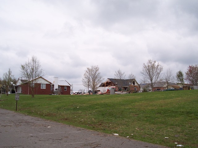       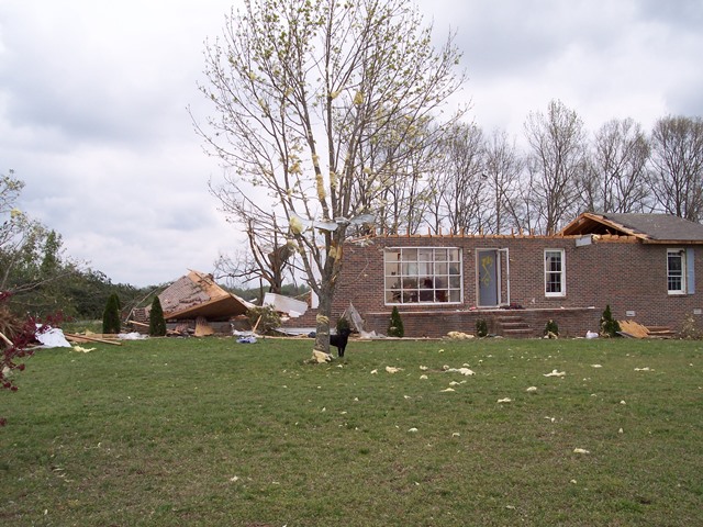           |
|
| EF1 White County Tornado | |
| Counties: | White |
| Time: | 1:20 PM CST |
| EF Scale: | EF1 |
| Damage Path Length: | 1.75 miles |
| Damage Path Width: | 800 yards |
| Fatalities: | 0 |
| Injuries | 0 |
| Damage: STORM DATA: Some homes were damaged. A power pole was snapped. One mobile home had roof torn off. Trees were snapped and uprooted. SHAMBURGER (2015): No NWS storm survey was conducted for this tornado. The 800 yard width of this tornado as listed in NCDC and Storm Data seems very unlikely for such a short track tornado, and is likely erroneous. Radar data also suggests only a brief small tornado touchdown occurred in this area. |
|


 Follow us on YouTube