
| Tornado Statistics | ||||||||
| # | Counties | Rating | Time (CST) | Length (miles) | Width (yards) | Fatalities | Injuries | |
| 1 | Hickman | F1 | 0136 | 10.80 | 100 | 0 | 0 | |
| 2 | Hickman/Williamson | F3 | 0156 | 19.70 | 700 | 0 | 1 | |
| 3 | Davidson/Wilson | F1 | 0207 | 15.30 | 200 | 0 | 0 | |
| 4 | Sumner | F1 | 0219 | 10.00 | 200 | 0 | 0 | |
| 5 | Williamson | F1 | 0228 | 1.35 | 200 | 0 | 0 | |
| 6 | Rutherford | F3 | 0245 | 8.63 | 400 | 0 | 0 | |
| 7 | Cumberland | F1 | 0419 | 1.30 | 75 | 0 | 0 | |
| Reports & Outlooks | |||
| SPC Storm Reports | SPC Day 1 Outlook | SPC Event Archive | Public Information Statement |
| F1 Hickman County Tornado | |
| Counties: | Hickman |
| Time: | 1:36 AM CST |
| EF Scale: | F1 |
| Damage Path Length: | 10.80 miles |
| Damage Path Width: | 100 yards |
| Fatalities: | 0 |
| Injuries | 0 |
| Damage: STORM DATA: Numerous trees were blown down from Sullivan Road, Defeated Creek and Easley's Bend Rd. There was a path of downed trees that stretched for 2 miles in the Trace Creek area to Easley's Bend. 22 trees were down in the Easley bend area alone. 2 homes received significant damage, mainly roof damage. "I"-beams that form a foundation in a mobile home were bent. SHAMBURGER (2015): No NWS storm survey was conducted for this damage. NCDC and Storm Data officially list this event in Hickman County as thunderstorm wind damage, even though this damage was originally reported as a tornado per SPC storm reports. However, radar data and aerial imagery from Google Earth clearly indicate this damage was caused by a QLCS tornado, and this tornado has been added to the NWS Nashville database. The time, path length, path width, and F-scale rating were all estimated based on radar data and the narrative in Storm Data. This EF1 tornado is estimated to have touched down just northeast of the Smithfield Road and Whitson Bend Road intersection, then tracked just south of due east through the Easley Bend area, across Highway 961, Defeated Creek Road, Highway 100, then lifting near Morgan Creek Road. Google Earth aerial imagery indicates the EF1 damage was in the first few miles of the track, with intermittent EF0 damage along the remainder of the tornado track. |
|
| F3 Hickman/Williamson County Tornado | ||
| Counties: | Hickman/Williamson | |
| Time: | 1:56 AM CST | |
| EF Scale: | F3 | |
| Damage Path Length: | 19.70 miles | |
| Damage Path Width: | 700 yards | |
| Fatalities: | 0 | |
| Injuries: | 1 | |
| Radar: | OHX BR/BV/SRV/SW Radar Loop | |
| Damage: STORM DATA: 43 homes were damaged and 3 homes were destroyed in Williamson County by the tornado. 28 units in the Executive House condominium complex in Franklin had to be evacuated after the roof was torn away. Crews worked Sunday to free people trapped inside their homes by fallen trees on Big East Fork Rd. Most of the damage to homes was roof damage and trees falling on houses. An 84-year-old grandmother was rescued from a demolished 3-story home at 1933 Old Hillsoboro Rd. She received a fractured pelvic bone. SHAMBURGER (2016): Only a limited NWS Storm Survey was conducted for this tornado. However, NCDC and Storm Data erroneously list the path of this tornado at just 1 mile long, when even the path as described in the Storm Data narrative would be over 5 miles long. Radar data and the damage path on Google Earth aerial imagery clearly indicate this major, long-track tornado began in far eastern Hickman County before moving eastward across western Williamson County, crossing Highway 46, Liberty Road, Deer Ridge Road, Sleepy Hollow Road, Caney Fork Road, Old Highway 96, and Walter King Road. The tornado appeared to reach peak intensity as it moved across Big East Fork Road, Natchez Trace Parkway, Waddell Hollow Road, and Old Hillsboro Road where thousands of trees were blown down. The tornado gradually weakened and narrowed in size as it moved into Franklin and passed over Highway 96, Old Charlotte Pike, Del Rio Pike, and Hillsboro Road before lifting west of Franklin Road just to the northeast of downtown Franklin. The time, location, path length, and path width of this tornado were significantly corrected based on radar data, the narrative in Storm Data, and Google Earth satellite imagery. |
||
Photos:         |
||
| F1 Davidson/Wilson County Tornado | |
| Counties: | Davidson/Wilson |
| Time: | 2:07 AM CST |
| EF Scale: | F1 |
| Damage Path Length: | 15.30 miles |
| Damage Path Width: | 200 yards |
| Fatalities: | 0 |
| Injuries | 0 |
| Damage: STORM DATA (Davidson County): There was damage to the roofs of homes and businesses. Several businesses had their signs damaged as well. The Davidson County tornado started about 5.3 miles northeast of downtown Nashville near Riverwood Drive. The tornado crossed the Cumberland River and affected the Opryland area and dissipated around Bonnameade Road or about 8.9 miles east northeast of downtown Nashville. STORM DATA (Wilson County): This was part of the same storm complex that struck Davidson County. This tornado travelled down Lebanon Pike. Many trees were blown down. A car wash was demolished. There was damage to roofs and business signs. Mt. Juliet does not have any tornado sirens, but 3 sirens have been ordered. SHAMBURGER (2015): Radar data clearly indicates the tornadoes listed separately in Davidson and Wilson Counties were actually the same tornado, and the two have been combined in this entry. The time, location, and path length were all corrected and estimated based on radar data, which indicates the tornado touched down southwest of the Hart Road and Ellington Parkway interchange in east Nashville, then moved eastward for around 15 miles before lifting near Lebanon Pike and Benders Ferry Road in Mount Juliet. |
|
Photos:      |
|
| F1 Sumner County Tornado | |
| Counties: | Sumner |
| Time: | 2:19 AM CST |
| EF Scale: | F1 |
| Damage Path Length: | 10.00 miles |
| Damage Path Width: | 200 yards |
| Fatalities: | 0 |
| Injuries | 0 |
| Damage: STORM DATA: Many trees were blown down along with considerable roof damage to homes. 147 houses and 18 mobile homes were damaged along with 2 businesses. A 36-foot RV parked behind a duplex on Connie Drive was turned upside down. Other areas that were hit hard were on Nicholas Lane, Lock 4 Road, Woodvale Subdivision, Drivers Lane and Peach Valley Road. SHAMBURGER (2015): NCDC and Storm Data incorrectly list the time, path length, and location of this tornado, which was corrected based on radar data and the narrative in Storm Data. |
|
| F1 Williamson County Tornado | |
| Counties: | Williamson |
| Time: | 2:28 AM CST |
| EF Scale: | F1 |
| Damage Path Length: | 1.35 miles |
| Damage Path Width: | 200 yards |
| Fatalities: | 0 |
| Injuries | 0 |
| Damage: STORM DATA: Trees were snapped and uprooted at intersection of Burke Hollow Road and Clovercroft Road. SHAMBURGER (2015): NCDC and Storm Data incorrectly list the time, location, and path length of this tornado, which were corrected based on radar data and the damage path on Google Earth aerial imagery. |
|
| F3 Rutherford County Tornado | |
| Counties: | Rutherford |
| Time: | 2:45 AM CST |
| EF Scale: | F3 |
| Damage Path Length: | 6.13 miles |
| Damage Path Width: | 400 yards |
| Fatalities: | 0 |
| Injuries | 0 |
| Damage: STORM DATA: At least 18 homes were destroyed and dozens more were damaged from the tornado. There was considerable damage at the Roanoke Subdivision. The old Bethel Missionary Baptist Church, located on Holly Grove Road which is just northeast of Walter Hill, will have to be torn down because of the tornado damage. The church has been at that location for more than 100 years. SHAMBURGER (2016): NCDC and Storm Data erroneously list the path of this tornado at just one mile, when even the description in Storm Data itself would be nearly 2 miles. Radar data, Google Earth satellite imagery, and reports from the Tennessean newspaper all clearly indicates that this major tornado began near the East Fork of the Stones River just south of Mt. Ayre Way, then tracked eastward across Highway 266, Roanoke Drive just north of Randolph Street, Dandelion Drive, Big Oak Drive in Walterhill where several homes were severely damaged and some even leveled. The tornado continued eastward across Highway 231 south of Juniper Drive before striking the Bethel Baptist Church on Holly Grove Road, which was also heavily damaged. Radar data and limited Google Earth satellite imagery both show the tornado continued eastward but weakened, lifting north of Lascassas to the west of Cainsville Pike, for a total path length around 6 miles. The time, path length, and location of this tornado have been corrected and estimated from a combination of radar data, Google Earth satellite imagery, Tennessean newspaper reports, and Storm Data. |
|
Photos:     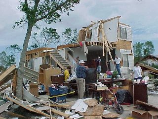    |
|
| F1 Cumberland County Tornado | |
| Counties: | Cumberland |
| Time: | 4:19 AM CST |
| EF Scale: | F1 |
| Damage Path Length: | 1.30 miles |
| Damage Path Width: | 75 yards |
| Fatalities: | 0 |
| Injuries | 0 |
| Damage: STORM DATA: Newspaper story about numerous downed trees in the southern part of the city. A shed was destroyed on Highland Dr. There were 16 homes damaged, and 21 power poles were broken. A large red oak tree fell and cut a home in half on Lantana Rd. Also, a large oak tree fell on a Jeep pickup on Mimosa Dr. The South Cumberland Elementary School had broken windows, damage to the roof, and one portable classroom was a total loss. SHAMBURGER (2015): No NWS storm survey was conducted for this damage. Although this event was originally included in NCDC and Storm Data as thunderstorm wind damage, radar data clearly indicates this event was a brief QLCS tornado, and this tornado has been added to the NWS Nashville database. The time, path length, path width, and F-scale rating were all estimated based on the narratives from the Crossville newspaper and Storm Data, radar data, and limited aerial imagery from Google Earth. |
|


 Follow us on YouTube