
| Tornado Statistics | ||||||||
| # | Counties | Rating | Time (CST) | Length (miles) | Width (yards) | Fatalities | Injuries | |
| 1 | Montgomery/Robertson | F1 | 0050 | 6.00 | 400 | 2 | 0 | |
| 2 | Robertson/Sumner | F2 | 0148 | 5.19 | 900 | 0 | 6 | |
| 3 | Coffee | F1 | 1732 | 4.10 | 50 | 0 | 0 | |
| 4 | Bedford/Coffee | F2 | 1845 | 13.10 | 500 | 2 | 27 | |
| 5 | Cumberland | F1 | 1901 | 3.40 | 400 | 0 | 0 | |
| 6 | Van Buren | F2 | 2010 | 2.90 | 100 | 0 | 0 | |
| 7 | Cumberland | F0 | 2035 | 0.10 | 20 | 0 | 0 | |
| 8 | Cumberland | F3 | 2134 | 12.20 | 900 | 4 | 18 | |
| Reports & Outlooks | |||
| SPC Storm Reports | SPC Day 1 Outlook | SPC Event Archive | Public Information Statements |
| F1 Montgomery/Robertson County Tornado | |
| Counties: | Montgomery/Robertson |
| Time: | 12:50 AM CST |
| EF Scale: | F1 |
| Damage Path Length: | 6.00 miles |
| Damage Path Width: | 400 yards |
| Fatalities: | 2 |
| Injuries | 0 |
| Damage: STORM DATA: The husband, Dennis Tooby and his wife, Karen Tooby, were killed when their mobile home was blown off its foundation at the 3400 block of Port Royal Rd. Mr. Tooby was a Australian national and a welder. Mrs. Tooby taught first grade at Hazelwood Elementary School in Clarksville. Two mobile homes were lifted off their foundation and hurled across the road. The tornado damaged 60 homes and one public building. Most of the damages were minor. SHAMBURGER (2015): NCDC and Storm Data erroneously list the path length, location, and time of this tornado, which were corrected based on radar data and a damage map created by NWS Nashville. In addition, NCDC and Storm Data incorrectly list a previous brief tornado in Montgomery County as separate from this tornado, when radar data and the damage map from NWS Nashville clearly indicate it was part of this tornado, and both have been combined in this entry. Finally, NCDC and Storm Data incorrectly list a brief tornado southwest of Adams in Robertson County as separate from this tornado, when radar data and the damage map from NWS Nashville clearly indicate it was also part of this tornado, and both have been combined in this entry. |
|
|
Port Royal, TN photos: |
|
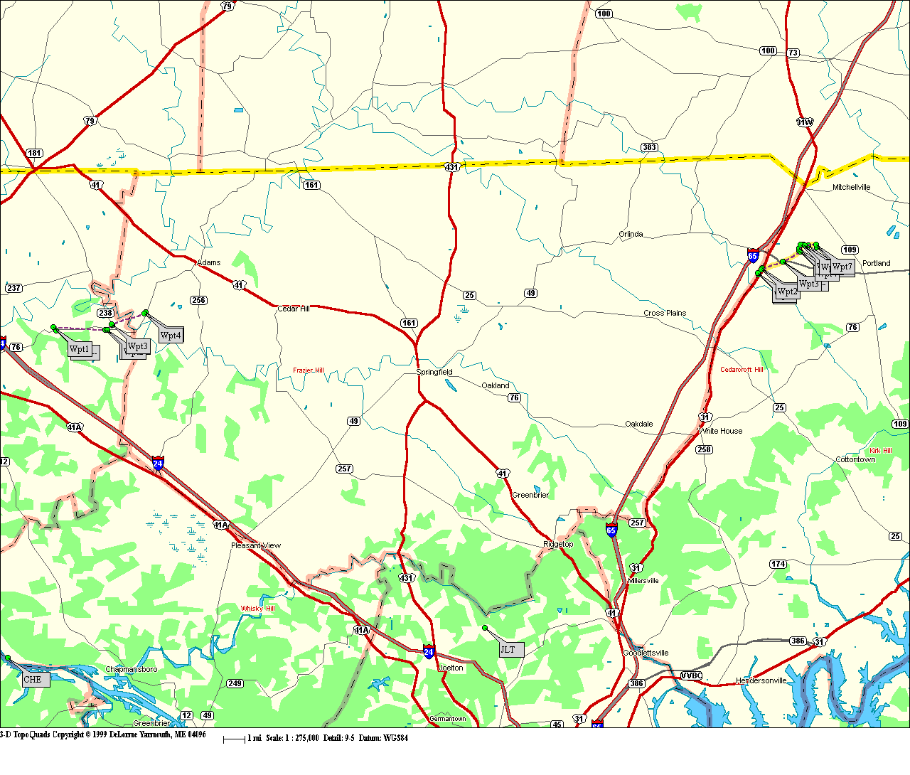
| F2 Robertson/Sumner County Tornado | ||
| Counties: | Robertson/Sumner | |
| Time: | 1:48 AM CST | |
| EF Scale: | F2 | |
| Damage Path Length: | 5.19 Miles | |
| Damage Path Width: | 900 yards | |
| Fatalities: | 0 | |
| Injuries: | 6 | |
| Damage: STORM DATA: One person was hospitalized due to injuries from the tornado. The other 5 people were treated and released for their injuries. 7 homes were destroyed, 15 homes had major damage and 14 had minor damage. 5 mobile homes were destroyed, 3 with major damage and 2 with minor damage. One business was destroyed and 3 other businesses were damaged. Several goats and cattle were killed. The heaviest damage was at 404 Glen Haven Rd. 2 mobile homes were destroyed and blown off their foundation. 18 outbuildings, 16 barns and 2 churches were damaged. A Chrysler Cirrus LX sedan was flipped and pushed 20 feet. A Ford Ranger truck flipped and rolled 90 feet. A 6 inch by 6 inch board was hurled through the roof of a modular home. Kirby Building Services located at 124 Kirby Road in the industrial park area, sustained 50 percent damage according to the Portland Fire Dept. SHAMBURGER (2015): NCDC and Storm Data incorrectly list the time, path length, and location of this tornado, which were corrected based on radar data, Google Earth aerial imagery, and the narrative in Storm Data. In addition, even though a map of the damage path by NWS Nashville shows this tornado began in Robertson County, that county is not officially included in NCDC or Storm Data. Robertson County was added to this entry, with the tornado estimated to have touched down near I-65, then moved east-northeast across Highway 31, Highway 52, and Highway 109 before lifting north of Kirby Drive. |
||
|
Portland, TN photos: |
||
| F1 Coffee County Tornado | |
| Counties: | Coffee |
| Time: | 5:32 PM CST |
| EF Scale: | F1 |
| Damage Path Length: | 4.10 miles |
| Damage Path Width: | 50 yards |
| Fatalities: | 0 |
| Injuries | 0 |
| Damage: STORM DATA: Trees were blown down and uprooted. SHAMBURGER (2015): NCDC lists the incorrect time and location for this tornado, which were corrected based on radar data. |
|
| F2 Bedford/Coffee County Tornado | |
| Counties: | Bedford/Coffee |
| Time: | 6:45 PM CST |
| EF Scale: | F2 |
| Damage Path Length: | 13.10 miles |
| Damage Path Width: | 500 yards |
| Fatalities: | 2 |
| Injuries | 27 |
| Damage: STORM DATA: An F2 tornado struck near Bugscuffle and caused very minor injuries. A second floor was torn off 2 late model frame houses. Several houses had roofs stripped and a couple of barns were demolished. TEMA reported 5 homes destroyed, 6 damaged, one mobile home destroyed and a TVA 500 KV tower was destroyed. This tornado went into Coffee county, where it killed 2 people and injured 24 others. The 2 people were inside their mobile home when the tornado struck. The mobile home was in the New Union Heights subdivision, off state Highway 53 north of Manchester. The boy was moved from his mobile home to the Hillcrest Baptist Church. He died in the church at 705 PM CST. A relative of the boy, a 43-year-old male, was also killed. He was impaled on the upright lid of a washing machine. In total, 24 homes were destroyed, 51 other homes were damaged. 9 mobile homes were destroyed and 5 were damaged. 14 outbuildings also were damaged. The tornado also blew down a tree and a light pole at 3737 Woodbury Highway at mile marker 9 on Woodbury Highway. Also, two fully loaded tracker trailer trucks were blown over on I-24 near Busy Corner or mile marker 105. One truck was in the east bound lane and the other tracker trailer truck in the west bound lane of I-24. SHAMBURGER (2015): This tornado was the worst to strike Coffee County since 1854. NCDC and Storm Data incorrectly list this tornado twice in Coffee County, and the erroneous second entry has been removed. In addition, NCDC and Storm Data erroneously list the time and location of this tornado, which were corrected based on radar data and Google Earth aerial imagery. |
|
|
Coffee County, TN photos: Photo #1: Tractor trailer overturned by tornado in Coffee County on I-24. Photo #2: Remains of a home in Coffee County after tornado Photo #3: Home demolished in Coffee County from a strong F2 tornado Photo #4: Original map of tornado path     |
|
| F1 Cumberland County Tornado | |
| Counties: | Cumberland |
| Time: | 7:01 PM CST |
| EF Scale: | F1 |
| Damage Path Length: | 3.40 miles |
| Damage Path Width: | 400 yards |
| Fatalities: | 0 |
| Injuries | 0 |
| Damage: STORM DATA: A tornado blew a tracter trailer truck on its side at the Crab Orchard interchange at I-40. This storm complex went on into Morgan county and spawned a tornado. SHAMBURGER (2015): NCDC and Storm Data incorrectly list the time and location of this tornado, which were corrected based on radar data. |
|
| F2 Van Buren County Tornado | |
| Counties: | Van Buren |
| Time: | 8:10 PM CST |
| EF Scale: | F2 |
| Damage Path Length: | 2.90 miles |
| Damage Path Width: | 20 yards |
| Fatalities: | 0 |
| Injuries | 0 |
| Damage: STORM DATA: EMA reported a frame house was demolished at intersection of Highway 111 and Highway 30. SHAMBURGER (2015): NCDC and Storm Data incorrectly list the path of this tornado, which was corrected based on radar data and Google Earth aerial imagery. The aerial imagery from Google Earth indicates several trees were blown down along a narrow path across the south and east sides of Spencer, from Old Dunlap Road to Hale Road to Sherwood Drive. |
|
| F0 Cumberland County Tornado | |
| Counties: | Cumberland |
| Time: | 8:35 PM CST |
| EF Scale: | F0 |
| Damage Path Length: | 0.10 miles |
| Damage Path Width: | 20 yards |
| Fatalities: | 0 |
| Injuries | 0 |
| Damage: STORM DATA: Law enforcement reported a tornado. No damage reported. |
|
| F3 Cumberland County Tornado | |
| Counties: | Cumberland |
| Time: | 9:34 PM CST |
| EF Scale: | F3 |
| Damage Path Length: | 12.20 miles |
| Damage Path Width: | 900 yards |
| Fatalities: | 4 |
| Injuries | 18 |
|
Damage: |
|
| Cumberland County, TN photos: Photo #1: House damaged from tornado in Cumberland County Photo #2: Debris from aftermath of the Cumberland County tornado Photo #3: Vehicle totaled by Cumberland County tornado    |
|
| Other Photos | |||
Greg Bearden, storm spotter in Maury County, provided the following photographs of storms that passed near his area on Sunday afternoon:    |
|||


 Follow us on YouTube