
| Overview | |||
| An historic tornado outbreak of at least 13 tornadoes struck Middle Tennessee on April 16, 1998. Many of these tornadoes were strong or violent and tracked long distances, killing 4 people and injuring nearly 100 people, while causing hundreds of millions of dollars in damage. The most infamous tornado during the outbreak struck downtown Nashville, blowing out numerous windows in skycrapers and causing the collapse of some older buildings. Other notable tornadoes included three violent tornadoes in southern Middle Tennessee that reached F4 to F5 intensity, and an F3 tornado in Pickett County that damaged or destroyed hundreds of homes and businesses. Wilson County was struck by 4 different tornadoes during the event. This tornado outbreak was unusual in several respects. First, the event lasted nearly the entire day, with the first round of severe weather beginning very early (around 4 AM CST), and the second and more significant round of severe thunderstorms and tornadoes occurring during the afternoon and evening. Second, synoptic features with this outbreak were not noticeably intense, with a relatively weak low level jet stream of only 35 to 45 mph at 850 mb (around 5000 feet above the ground), and a weak area of surface low pressure around 1000-1005 mb located well to the north across the Great Lakes. Upper air soundings at Nashville also were not noticeably impressive, with the 18Z sounding showing veered low level winds and only modest convective available potential energy (CAPE) around 1000 J/Kg. However, a large wind maximum at 500 mb (around 20,000 feet above the ground) of 80 to 90 mph extended from Texas into the Tennessee Valley region, which provided considerable lift for severe thunderstorms to develop throughout the day. Due to several errors apparent in official Storm Data records for this historic event, a reanalysis was undertaken in 2013 by NWS Nashville lead forecaster Sam Shamburger using radar data, NWS research and documentation, spotter reports, aerial damage surveys, and Google Earth high resolution satellite imagery. Based on this information, several updates were made to the times, paths, and damage information for these tornadoes. Some of the longer track tornadoes were also determined to be separate tornadoes, and a final total of 13 tornadoes is listed below. However, a few other tornadoes may have also touched down across Middle Tennessee, as suggested by radar imagery. |
|||
| Tornado Statistics | ||||||||
| # | Counties | Rating | Time | Path | Width | Fatalities | Injuries | |
| 1 | Dickson | F3 | 0605 | 2.0 | 1300 | 0 | 5 | |
| 2 | Montgomery/Robertson | F3 | 0914 | 12.5 | 400 | 0 | 0 | |
| 3 | Humphreys | F0 | 1009 | 0.5 | 100 | 0 | 0 | |
| 4 | Macon | F2 | 1108 | 3.0 | 800 | 0 | 0 | |
| 5 | Cheatham | F0 | 1414 | 0.5 | 100 | 0 | 0 | |
| 6 | Davidson/Wilson | F3 | 1426 | 28.0 | 1320 | 1 | 60 | |
| 7 | Wilson/Trousdale | F1 | 1505 | 15.9 | 880 | 0 | 0 | |
| 8 | Hardin/Wayne | F4 | 1550 | 30.1 | 1760 | 3 | 6 | |
| 9 | Wilson | F2 | 1556 | 9.6 | 880 | 0 | 0 | |
| 10 | Wayne/Lawrence | F5 | 1630 | 20 | 1760 | 0 | 21 | |
| 11 | Davidson/Wilson | F1 | 1627 | 5.4 | 200 | 0 | 0 | |
| 12 | Pickett | F3 | 1635 | 8.6 | 880 | 0 | 4 | |
| 13 | Lawrence/Giles/Maury | F4 | 1700 | 20 | 1320 | 0 | 9 | |
| Upper Air Analysis from Plymouth State University & University of Wyoming | ||||||||
| Date/Time | 00Z April 16 1998 | 12Z April 16 1998 | 18Z April 16 1998 | 00Z April 17 1998 | 12Z April 17 1998 | |||
| 300 MB Heights | 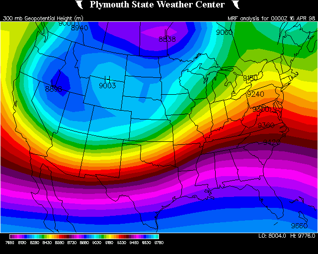 |
 |
N/A | |
|
|||
| 500 MB Winds |  |
 |
N/A |  |
 |
|||
| 850 MB Winds |  |
 |
N/A |  |
 |
|||
| 1000 MB Heights |  |
 |
N/A |  |
 |
|||
| Soundings | |
 |
 |
 |
 |
|||
| Research & Reports | |||
| NWS Nashville Summary of Storm Surveys of April 16, 1998 - Page 1 / Page 2 | |||
| Aerial Surveys by Tim Troutman, NWS & Tim Marshall, Haag Engineering - Page 1 / Page 2 | |||
| The Forgotten F5 | |||
| NWS Nashville Operations by Forecaster Bobby Boyd | |||
| Comparison of Radar Velocity Signatures to Tornado Damage | |||
| Tennessee State Library and Archives | |||
| April 1998 Storm Data | |||
| Radar Imagery | |
| OHX 0.5° Base Reflectivity Loop (State view) |  |
| OHX 0.5° Base Reflectivity Loop (Nashville Metro) | |
| OHX 1.5° Base Velocity Loop (State view) | |
| OHX 1.5° Base Velocity Loop (Nashville Metro) | |
| Photos | |||
| Nashville Tornado Photos by Derek Edwards | |||

| Dickson County Tornado | ||||||||||
| # | Rating | Time | Length | Width | Fatalities | Injuries | Damage | |||
| 1 | F3 | 0605 | 2.0 mi | 1300 yds | 0 | 5 | $500,000 | |||
|
(From April 1998 Storm Data) The tornado destroyed or damaged 35 homes, destroyed 7 mobile homes, uprooted trees and demolished cars along a 2 mile path on Nails Creek Road. The Dickson Convention Center/Flea Port USA, on TN Route 46 South, lost a wall and part of a roof. (2013 Reanalysis) Based on radar data, the time of the tornado was changed to 0605 CST. |
||||||||||
   |
||||||||||
| Montgomery/Robertson County Tornado | ||||||||||
| # | Rating | Time | Length | Width | Fatalities | Injuries | Damage | |||
| 2 | F3 | 0914 | 12.5 mi | 1300 yds | 0 | 0 | $410,000 | |||
|
(From April 1998 Storm Data) Many trees and power lines were blown down at Port Royal and Sandlerville Road. Homes were damaged. A TVA transmission line tower fell. The tornado moved into Robertson County, where part of a roof was blown off the Jo Byrns School in Adams. Many trees fell on homes. (2013 Reanalysis) Based on radar data, the time of the tornado was changed to 0914 CST, with the path increased to 12.5 miles. |
||||||||||
   |
||||||||||
| Humphreys County Tornado | ||||||||||
| # | Rating | Time | Length | Width | Fatalities | Injuries | Damage | |||
| 3 | F0 | 1009 | 0.5 mi | 100 yds | 0 | 0 | $0 | |||
|
(From April 1998 Storm Data) Spotter reported a tornado on I-40 between mile marker 145 and 146. (2013 Reanalysis) Based on radar data, the time of the tornado was changed to 1009 CST. |
||||||||||
   |
||||||||||
| Macon County Tornado | ||||||||||
| # | Rating | Time | Length | Width | Fatalities | Injuries | Damage | |||
| 4 | F2 | 1109 | 3.0 mi | 800 yds | 0 | 0 | $5,000 | |||
|
(From April 1998 Storm Data) Many trees and power lines were blown down. A roof was damaged to a house and also a barn on White Springs Road from large tree branches. (2013 Reanalysis) Based on radar data, the time of the tornado was changed to 1109 CST. The location of the tornado in Storm Data was also corrected from the Willette area, which is in far southeastern Macon County, to the White Springs Road area, which is in northwestern Macon County. Little documentation exists on this tornado, and the F2 rating based on the limited damage reports and radar data is almost certainly too high. |
||||||||||
   |
||||||||||
| Cheatham County Tornado | ||||||||||
| # | Rating | Time | Length | Width | Fatalities | Injuries | Damage | |||
| 5 | F0 | 1414 | 0.5 mi | 100 yds | 0 | 0 | $0 | |||
|
(From April 1998 Storm Data) No information was given on this tornado. (2013 Reanalysis) Based on radar data, the beginning time of the tornado was corrected to 1414 CST. This tornado was originally reported as touching down west of Ashland City, but no mesocyclones passed through that area. At some point the location of this tornado was moved to Pegram, but no reason was given. Radar analysis indicates this may have been a false tornado report. |
||||||||||
   |
||||||||||
| Davidson/Wilson County Tornado | ||||||||||
| # | Rating | Time | Length | Width | Fatalities | Injuries | Damage | |||
| 6 | F3 | 1426 | 28.0 mi | 1320 yds | 1 | 60 | $100,000,000 | |||
|
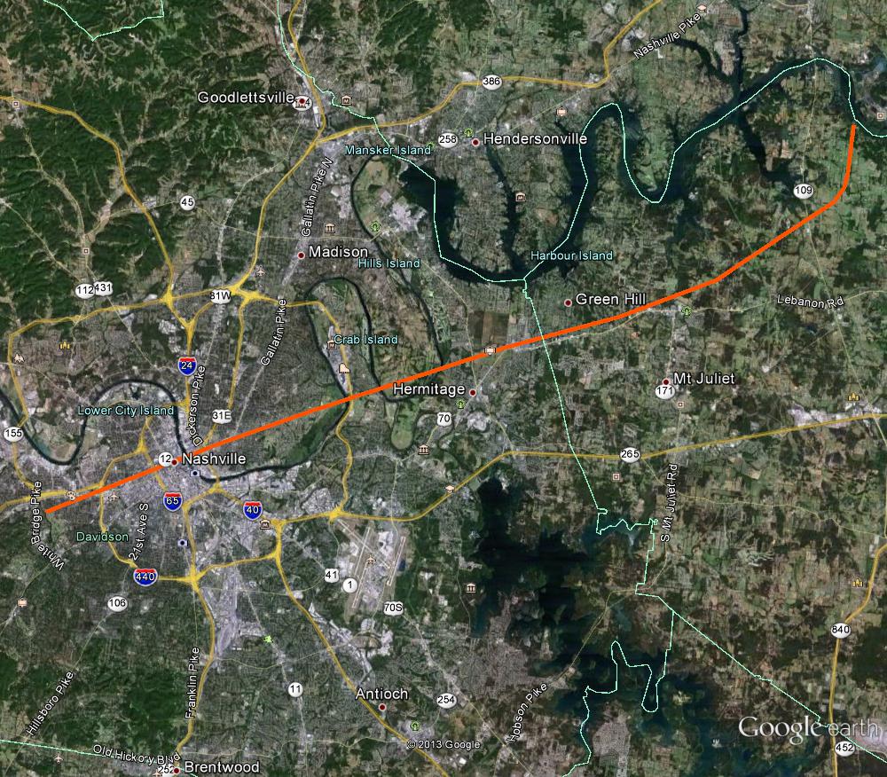
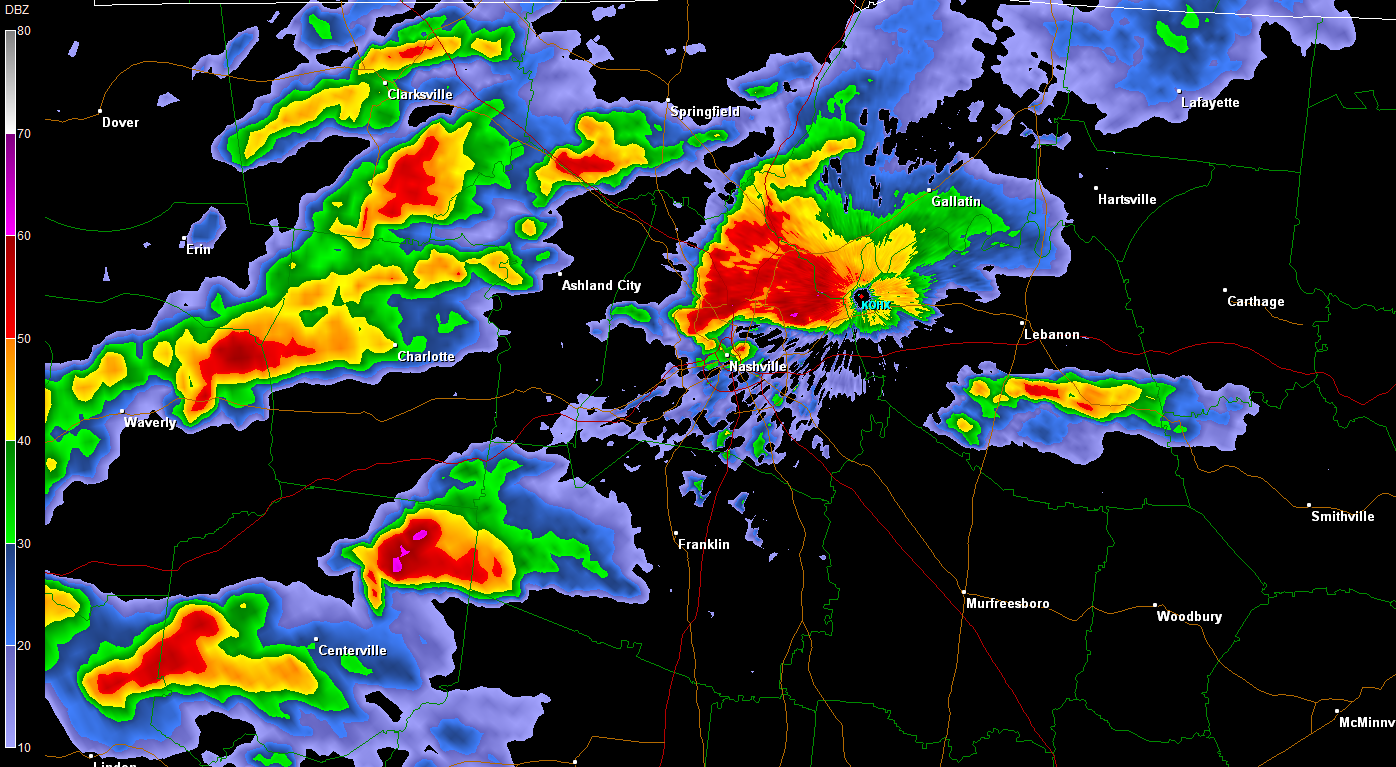
(From April 1998 Storm Data) This Nashville tornado on April 16, 1998 took a very similar path to another F3 tornado that occurred on March 14, 1933, which killed 11 people in Nashville. The tornado touched down at 330 PM one mile west of Charlotte Pike and I-440. A tree fell on an ROTC student at Centennial Park. He was attending an ROTC picnic. He died later on May 4 from his injuries. The tornado went through downtown Nashville at 340 PM and on toward East Nashville, Donelson and Hermitage. The tornado blew out many windows on office buildings. The Nations Bank Office Towers were one of the hardest hit buildings in Nashville. Tennessee Performance Arts Center (TPAC) and the Tennessee Towers sustained damage. TPAC had over 100 windows blown out. NOAA Weather Radio broadcasts from the Tennessee Towers and was off the air for about 24 hours. 30 private airplanes were damaged at Cornelia Fort Airport. Estimated damage to the airplanes was 3 million dollars. 35 buildings in downtown Nashville were "red tagged", meaning these buildings were structurally unsound. Many signs in Davidson county were blown down or severely damaged. The tornado blew down 3 out of 10 construction cranes on the construction site of the Tennessee Oiler's Football Stadium near the Cumberland River. The tornado continued east and hit the residential section of East Nashville. At least 300 homes were damaged in East Nashville. Many homes lost a good part of their roofs, trees were uprooted, telephone poles were knocked down. St. Ann's Episcopal Church, which is well over 100 years old, received major damage. Uprooted trees, damaged roofs to many homes was the story across Donelson and Hermitage. Numerous windows were blown out from the Gaylord Building in Donelson. About half the trees, that is over a thousand trees, were blown down at Andrew Jackson's home, The Hermitage. The Hermitage is a 600 acre estate of the former President. Some of those trees were well over 200 years old, and a few of those trees that were destroyed were planted by Andrew Jackson himself. Mayor Phil Bredesen closed downtown Nashville of Friday, April 17. Many workers had an unscheduled holiday. The downtown area was reopened Monday, April 20. This gave time for cleanup crews to remove broken glass and repair downed power lines. Nashville Electric Service said 75,000 customers were without power. The tornado moved into Wilson County, and was seen moving from west to east about a mile south of the NWS office. The tornado caused many trees to be uprooted, power lines were knocked down, signs damaged or blown down, and there was roof damage to homes. The Mt. Juliet Little League field was littered with aluminum and lumber blown from Marvin's Lumber Yard. Part of a roof was taken off First Bank in Mt. Juliet. (2013 Reanalysis) Based on radar data, the beginning time of the tornado was changed to 1426 CST. Radar data also clearly indicates this tornado turned northward and occluded just east of Highway 109 in Wilson County, and then dissipated near the Cumberland River never entering Trousdale County. As this occurred, radar shows a new tornado touched down further to the east. Therefore the path length was corrected to 28 miles. Most NWS personnel today would rate this as an EF2 tornado, not F3. Photos 1-3: Map of the Nashville tornado path and radar imagery of the parent supercell. |
||||||||||
   |
||||||||||
   |
||||||||||
   |
||||||||||
| Wilson/Trousdale County Tornado | ||||||||||
| # | Rating | Time | Length | Width | Fatalities | Injuries | Damage | |||
| 7 | F1 | 1505 | 15.9 mi | 200 yds | 0 | 0 | $1,000,000 | |||
|
(From April 1998 Storm Data) Trees were blown down in rural areas. (2013 Reanalysis) This tornado was originally included as part of the Downtown Nashville tornado, but is clearly a separate tornado based on radar data. The beginning time and location of the tornado was added as 1505 CST near Cairo Bend Road northwest of Lebanon, with the tornado dissipating near or just over the southern Trousdale County border. The path length was added as 15.9 miles based on radar data, with the path width estimated. Estimates from radar base velocity wind speeds would put this tornado in the F1 range. |
||||||||||
   |
||||||||||
| Hardin/Wayne County Tornado | ||||||||||
| # | Rating | Time | Length | Width | Fatalities | Injuries | Damage | |||
| 8 | F4 | 1550 | 30.1 mi | 1760 yds | 3 | 6 | $4,000,000 | |||
|
(From April 1998 Storm Data) The tornado killed 3 people in Wayne county. 2 females, their ages 75 and 57, were killed in a modular home on Lay Creek Rd . Another female, age 69, was killed on Lay Creek Road in a wooden frame home. The tornado left nothing but the foundation. A lumber yard was destroyed. Many trees were down in the path of the tornado. Many houses and mobile homes were destroyed. 34 homes were completely destroyed, 14 homes had major damage and 22 had minor damage.. (2013 Reanalysis) This tornado was included in Storm Data as part of a single very long track F5 tornado that extended across Hardin, Wayne, Lawrence, Giles, and Maury counties. However, all NWS documentation, aerial storm surveys, spotter reports, and Google Earth aerial imagery indicate this long track was clearly three separate violent tornadoes, each with a well-defined occlusion and break in the damage path. This very large and violent tornado was the first of the three tornadoes, and began around 5 miles southeast of Savannah before lifting near the Natchez Trace Parkway in eastern Lawrence County. The path length was added as 30.1 miles based on Google Earth imagery, which also showed tens of thousands of trees blown down along a nearly 1 mile width swath. Some NWS personnel today might rate this as an EF5 tornado, based on the severity of the damage in Wayne County. Official Storm Data records erroneously do not include the Hardin County portion of the path of this tornado. |
||||||||||
   |
||||||||||
   |
||||||||||
| Wilson County Tornado | ||||||||||
| # | Rating | Time | Length | Width | Fatalities | Injuries | Damage | |||
| 9 | F2 | 1556 | 9.6 mi | 880 yds | 0 | 0 | $3,000,000 | |||
|
(From April 1998 Storm Data) This tornado travelled just south of Lebanon Pike and did damage to homes and businesses in West Lebanon. The TRW plant received some damage on HWY 70 Bypass. Trees were uprooted and homes sustained roof damage. There was extensive agricultural losses. Approximately $60,000 worth of fencing was destroyed or damaged. 20 hogs were killed. Farmers lost 26 outbuildings, and 21 vehicles were damaged. (2013 Reanalysis) This tornado was originally listed as beginning in Davidson County, but radar data clearly indicates the tornado began just east of Belinda City south of Interstate 40 around 1556 CST. The tornado then moved northeast across the west and north sides of Lebanon before dissipating. The path length was changed to 9.6 miles based on radar data. |
||||||||||
   |
||||||||||
| Wayne/Lawrence County Tornado | ||||||||||
| # | Rating | Time | Length | Width | Fatalities | Injuries | Damage | |||
| 10 | F5 | 1630 | 19.3 mi | 1760 yds | 0 | 21 | $4,000,000 | |||
|
(From April 1998 Storm Data) Many fine homes, some even brick, were completely leveled. Trees were uprooted or blown down, power lines were down, 75 utility poles were blown down around the county. People who were at their homes went to the basement, or in a closet, or in a bathroom. A tree was debarked by the flying debris. A 200 yard wide path of pasture land had grass pulled out. Clumps of dirt was pulled up from the ground. Several livestock were killed. (2013 Reanalysis) This tornado was originally included in Storm Data as part of a single very long track F5 tornado that extended across Hardin, Wayne, Lawrence, Giles, and Maury counties. However, all NWS documentation, aerial surveys, spotter reports, and Google Earth aerial imagery indicate this long track was clearly three separate violent tornadoes, each with a well-defined occlusion and break in the damage path. This was the second large and violent tornado, and began in far eastern Wayne County before moving northeast across Lawrence County to the north of Deerfield and south of Summertown before ending northeast of Ethridge. The beginning time and path length were added as 1630 CST and 19.3 miles based on radar data, damage reports and Google Earth imagery. |
||||||||||
    |
||||||||||
.jpg) .jpg) .jpg) .jpg) |
||||||||||
.jpg) .jpg) .jpg) .jpg) |
||||||||||
.jpg) .jpg) .jpg) .jpg) |
||||||||||
| Davidson/Wilson County Tornado #2 | ||||||||||
| # | Rating | Time | Length | Width | Fatalities | Injuries | Damage | |||
| 11 | F1 | 1627 | 9.8 mi | 200 yds | 0 | 0 | $100,000 | |||
|
(From April 1998 Storm Data) Trees were blown down. There was some damage to homes from fallen trees. This tornado was not as strong as the first. It started between downtown and Nashville International Airport and continued into Wilson county. (2013 Reanalysis) This tornado was originally included in Storm Data as part of the Lebanon tornado at 1556 CST. However, radar data indicates this tornado clearly began much further to the northwest in the Donelson/Hermitage area, then moved eastward and crossed the path of the Downtown Nashville tornado in the Hermitage/Mount Juliet area. This tornado can also be considered as the second tornado in Nashville this day. A third Nashville tornado was also included in the downtown area in Storm Data, but all NWS documentation indicates that was a duplicate of the first Downtown Nashville tornado. No documentation exists in damage reports warranting a rating over F1, and radar data indicates wind speeds in the F0 to possibly F1 range. The beginning time, path length, and path width were estimated based on radar data. |
||||||||||
   |
||||||||||
| Pickett County Tornado | ||||||||||
| # | Rating | Time | Length | Width | Fatalities | Injuries | Damage | |||
| 12 | F3 | 1635 | 8.6 mi | 880 yds | 0 | 4 | $11,000,000 | |||
|
(From April 1998 Storm Data) 40 homes and 22 mobile homes were destroyed from this tornado. 95% of the trees were destroyed in the path of the tornado. 45 utility poles were blown down. 100 barns were destroyed, 2 green houses were heavily damaged, and there was damage to fences and pasture land. There were 4 people injured, but they were treated and released. (2013 Reanalysis) This tornado was very well-documented by Pickett County Emergency Management, and the map below was recreated from the original TEMA report. |
||||||||||
   |
||||||||||
| Lawrence/Giles/Maury County Tornado | ||||||||||
| # | Rating | Time | Length | Width | Fatalities | Injuries | Damage | |||
| 13 | F4 | 1700 | 18.7 mi | 1320 yds | 0 | 9 | $5,000,000 | |||
|
(From April 1998 Storm Data) The most extensive damage was north of Yokley. There were downed trees and power lines, a ruptured gas tank, cars overturned, and homes damaged. 5 homes and 8 mobile homes were destroyed in Giles county. The heaviest damage in Maury County was in the Culleoka-Tice Town area. An 18 wheeler was blown over. Many homes were damaged, trees and power lines were down. Several trailers were destroyed or damaged. (2013 Reanalysis) This tornado was originally included in Storm Data as part of the very long track F5 tornado that extended across Hardin, Wayne, Lawrence, Giles, and Maury counties. However, all NWS documentation, aerial surveys, spotter reports, and Google Earth aerial imagery indicate this long track was clearly three separate violent tornadoes, each with a well-defined occlusion and break in the damage path. This large and violent tornado was the third of these three tornadoes, and began in far eastern Lawrence County before moving northeast across far northwestern Giles County to the north of Yokley before ending east of Culleoka in Maury County to the west of I-65. The beginning time and path length were estimated based on radar data, damage reports and Google Earth imagery. |
||||||||||
   |
||||||||||


 Follow us on YouTube